

Piako River
Encyclopedia
Firth of Thames
The Firth of Thames is a large bay located in the north of the North Island of New Zealand. It is the firth of the rivers Waihou and Piako, the former of which was formerly named the Thames River, and the town of Thames lies on its southeastern coast....
on the North Island
North Island
The North Island is one of the two main islands of New Zealand, separated from the much less populous South Island by Cook Strait. The island is in area, making it the world's 14th-largest island...
of New Zealand
New Zealand
New Zealand is an island country in the south-western Pacific Ocean comprising two main landmasses and numerous smaller islands. The country is situated some east of Australia across the Tasman Sea, and roughly south of the Pacific island nations of New Caledonia, Fiji, and Tonga...
. Together with the Waihou River
Waihou River
thumb|The Waihou River near [[Putaruru]]The Waihou River is located in the northern North Island of New Zealand. Its former name, Thames River, was bestowed by Captain James Cook....
, it is one of the two main rivers systems which drains the Hauraki Plains
Hauraki Plains
The Hauraki Plains are a geographical feature and non-administrative area located in the northern North Island of New Zealand, at the lower end of the Thames Valley...
. It is the dominant river system in the Matamata-Piako District
Matamata-Piako District
The Matamata-Piako District is a local government area in the Waikato region of New Zealand. It lies to the east of the city of Hamilton.The district encompasses the southern end of the Hauraki Plains and much of the Thames Valley, and is bounded in the east by the Kaimai Range...
, and on its journey it passes through the towns of Morrinsville
Morrinsville
Morrinsville is a town in the Waikato region of New Zealand's North Island. The land for the town and surrounding farmland was purchased from Wirimu Tamehana,the king maker prior to the NZ land wars of the 1860s. The land then was very swampy...
and Ngatea
Ngatea
Ngatea is a small town on the Hauraki Plains in the North Island of New Zealand. It is located 18 kilometres southwest of Thames and 70 kilometres southeast of Auckland. Ngatea lies on the Piako River, eight kilometres south of its outflow into the Firth of Thames.Ngatea is the 'service centre' for...
.
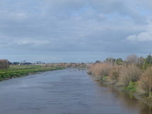
The Piako River has an annual mean flow of 17 m3 s−1 (at Paeroa-Tahuna Road), with a total catchment area of approximately 1,440 km2. The river system is approximately 100 km in length, aligned in a north-south direction and occupies much of the central and western Hauraki Plains (or more broadly, the Thames Valley), extending from Hinuera in the south before discharging into the Firth of Thames in the north, five kilometres west of Thames
Thames, New Zealand
Thames is a town at the southwestern end of the Coromandel Peninsula in New Zealand's North Island. It is located on the Firth of Thames close to the mouth of the Waihou River. The town is the seat of the Thames-Coromandel District Council....
.
The Piako River has two major stems: the main stem arises in the northern slopes of the Te Miro-Tahuroa hills, descending as two distinct tributaries – the Piakonui and the Piakoiti Streams. These streams, together with the Toenepi Stream, converge just south of Kereone. On the boundary of Morrinsville
Morrinsville
Morrinsville is a town in the Waikato region of New Zealand's North Island. The land for the town and surrounding farmland was purchased from Wirimu Tamehana,the king maker prior to the NZ land wars of the 1860s. The land then was very swampy...
, the Waitakaruru Stream, which drains the northwestern Te Miro-Tahuroa Hills, converges with the Piako River. As it progresses north, the Piako River is feed by small streams draining the eastern slopes of the Maungakawa Hills.
The second main stem is that of the Waitoa River
Waitoa River
The Waitoa River is a major river of the Waikato Region of New Zealand's North Island. It flows initially northeast from its origins at Piarere , before veering north through the Hinurea Flats to pass to the west of Matamata and Waharoa before running through the settlement of Waitoa and reaching...
, which starts near Piarere. The Waitoa River catchment drains the Hinuera Flats and broad southern Hauraki Plains, before converging with the Piako River in the large wetland known as the Kopuatai Peat Dome
Kopuatai Peat Dome
The Kopuatai Peat Dome is a wetland on the Hauraki Plains in New Zealand.The 10,201 ha wetland was listed under the Ramsar Convention in 1989 as a Wetland of International Importance...
, northeast of Tahuna. The Upper Piako River catchment also drains the eastern aspects of the Hapuakohe Range through small tributaries.
The river system is highly modified by intensive dairy farming and associated industry. Given this, the Toenepi Stream - a small sub-catchment of the Piako River - has been extensively used to research the impact of intensive farming on water quality.
Since the 1930s, considerable flood protection measures have been undertaken on the Piako River and surrounding catchment, especially mainly north of Paeroa-Tahuna Road and the Kopuatai Peat Dome. The scheme includes river management works, river diversions and channel enlargement, ponding systems, floodway improvements, stopbanks, floodgates and pumps.
The scheme works includes the following:
- Main river and tributary channel enlargement and clearing work,
- 170 km of stopbanks,
- 59 floodgates and
- 32 pump stations
The scheme provides the following levels of service:
- 100 yr protection from tidal flooding with 0.5m freeboard,
- 50 year protection from Piako River flooding with 0.3m freeboard
Piako River Bridge (Ngatea)
The original Piako River Bridge was built in NgateaNgatea
Ngatea is a small town on the Hauraki Plains in the North Island of New Zealand. It is located 18 kilometres southwest of Thames and 70 kilometres southeast of Auckland. Ngatea lies on the Piako River, eight kilometres south of its outflow into the Firth of Thames.Ngatea is the 'service centre' for...
and opened in 1917. In the earliest days all transport or access to and from the land was either by sea, river or canal, but with the first roads being developed, it was essential that a bridge be built over the Piako River so it could become a main route between Auckland and Tauranga. Considerable work has gone into restoring the banks of the river, as in winter it is the direct cause of flooding through the low-lying Hauraki Plains