

Coromandel Range
Encyclopedia
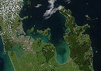
Coromandel Peninsula
The Coromandel Peninsula lies in the North Island of New Zealand. It is part of the Waikato Region and Thames-Coromandel District and extends 85 kilometres north from the western end of the Bay of Plenty, forming a natural barrier to protect the Hauraki Gulf and the Firth of Thames in the west...
in the North Island
North Island
The North Island is one of the two main islands of New Zealand, separated from the much less populous South Island by Cook Strait. The island is in area, making it the world's 14th-largest island...
of New Zealand
New Zealand
New Zealand is an island country in the south-western Pacific Ocean comprising two main landmasses and numerous smaller islands. The country is situated some east of Australia across the Tasman Sea, and roughly south of the Pacific island nations of New Caledonia, Fiji, and Tonga...
. It is located 60 kilometres east of the city of Auckland
Auckland
The Auckland metropolitan area , in the North Island of New Zealand, is the largest and most populous urban area in the country with residents, percent of the country's population. Auckland also has the largest Polynesian population of any city in the world...
, and runs north-south for approximately 85 kilometres. The highest point in the range is Mount Moehau (892 metres), at the northern end of the peninsula within the Moehau Range
Moehau Range
The Moehau Range is the northernmost range on the Coromandel Peninsula, extending from the settlement of Colville northwards to the tip of the peninsula. Mt Moehau is the highest point of the range, at 892m above sea level.-Physical Geography:...
. There are numerous peaks over 600 metres in height.
The range is one of several that form a spine running through the northern North Island. To the south of the Coromandel Range, separated by the winding Karangahake Gorge
Karangahake Gorge
The Karangahake Gorge lies between the Coromandel and Kaimai ranges, at the southern end of the Coromandel Peninsula in New Zealand's North Island. A sharply winding canyon, it was formed by the Ohinemuri River. State Highway 2 passes through this gorge between the towns of Paeroa, Waikino and Waihi...
, the spine continues with the Kaimai Range.
The large island of Great Barrier
Great Barrier Island
Great Barrier Island is a large island of New Zealand, situated to the north-east of central Auckland in the outer Hauraki Gulf. With an area of it is the fourth-largest island of New Zealand's main chain of islands, with its highest point, Mount Hobson, rising...
, at the entrance to the Hauraki Gulf
Hauraki Gulf
The Hauraki Gulf is a coastal feature of the North Island of New Zealand. It has a total area of 4000 km², and lies between the Auckland Region, the Hauraki Plains, the Coromandel Peninsula and Great Barrier Island...
due north of the Coromandel Peninsula, can be thought of as a northern continuation of this spine.