
Greensand Way
Encyclopedia
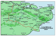
The Greensand Way is long distance walk of 108 miles (173.8 km) in southeast England, from Haslemere
in Surrey to Hamstreet
in Kent. It follows the Greensand Ridge
along the Surrey Hills
and Chart Hills. The route is mostly rural
, passing through woods
, and alongside fruit orchard
s and hop
farm
s in Kent and links with the Stour Valley Walk
near Pluckley
in Kent. The trail was opened on 15th June 1980.
On Ordnance Survey
Explorer map 145, a spur - also labelled Greensand Way - is shown from Thursley to Farnham
. This is not a standard part of the path.
Much of the land is designated an Area of Outstanding Natural Beauty
. The stretch from Hindhead to Leith Hill has formed part of the Surrey Hills AONB since 1958. The Sevenoaks Ridge, from the Surrey-Kent border to Borough Green, is included in the Kent Downs AONB.
 Places passed along the trail include: Hindhead
, Thursley
, Wormley, Hambledon
, Hascombe
, Shamley Green
, Holmbury St Mary
, Wotton
, Westcott
, Dorking
, Brockham
, Betchworth
, Earlswood, South Nutfield
, Bletchingley
, Tandridge
, Broadham Green, Limpsfield
, Crockham Hill
, Toys Hill
, Ide Hill
, Sevenoaks Weald
, Knole Park, Shipbourne
, Dunk's Green, West Peckham
, Nettlestead Green
, Yalding
, Linton
, Sutton Valence
, Egerton
, Pluckley
, Little Chart
, Hothfield
, Kingsnorth
and finally Hamstreet
.
Haslemere
Haslemere is a town in Surrey, England, close to the border with both Hampshire and West Sussex. The major road between London and Portsmouth, the A3, lies to the west, and a branch of the River Wey to the south. Haslemere is approximately south-west of Guildford.Haslemere is surrounded by hills,...
in Surrey to Hamstreet
Hamstreet
Hamstreet is a village in Kent, in South East England.The village is located some 6 miles south of Ashford on the A2070, the main road between Ashford and Hastings...
in Kent. It follows the Greensand Ridge
Greensand Ridge
The Greensand Ridge is an extensive, prominent, often heavily wooded, sandstone escarpment and range of hills in south-east England. It runs in a horseshoe shape around the Weald of Surrey, Sussex and Kent. It reaches its highest elevation, , at Leith Hill in Surrey—the second highest point...
along the Surrey Hills
Surrey Hills AONB
The Surrey Hills is a Area of Outstanding Natural Beauty , located in Surrey, England. The AONB was designated in 1958 and covers one quarter of the county of Surrey...
and Chart Hills. The route is mostly rural
Rural
Rural areas or the country or countryside are areas that are not urbanized, though when large areas are described, country towns and smaller cities will be included. They have a low population density, and typically much of the land is devoted to agriculture...
, passing through woods
Woodland
Ecologically, a woodland is a low-density forest forming open habitats with plenty of sunlight and limited shade. Woodlands may support an understory of shrubs and herbaceous plants including grasses. Woodland may form a transition to shrubland under drier conditions or during early stages of...
, and alongside fruit orchard
Orchard
An orchard is an intentional planting of trees or shrubs that is maintained for food production. Orchards comprise fruit or nut-producing trees which are grown for commercial production. Orchards are also sometimes a feature of large gardens, where they serve an aesthetic as well as a productive...
s and hop
Hop (plant)
Humulus, Hop, is a small genus of flowering plants native to temperate regions of the Northern Hemisphere. The female flowers of H. lupulus are known as hops, and are used as a culinary flavoring and stabilizer, especially in the brewing of beer...
farm
Farm
A farm is an area of land, or, for aquaculture, lake, river or sea, including various structures, devoted primarily to the practice of producing and managing food , fibres and, increasingly, fuel. It is the basic production facility in food production. Farms may be owned and operated by a single...
s in Kent and links with the Stour Valley Walk
Stour Valley Walk
The Stour Valley Walk is a recreational walking route that follows the River Stour, through the Low Weald and Kent Downs, from its source at Lenham to its estuary at Pegwell Bay....
near Pluckley
Pluckley
Pluckley is a village and civil parish in the Ashford District of Kent, United Kingdom. It is located close to the North Downs, and is approximately 5 miles west of Ashford...
in Kent. The trail was opened on 15th June 1980.
On Ordnance Survey
Ordnance Survey
Ordnance Survey , an executive agency and non-ministerial government department of the Government of the United Kingdom, is the national mapping agency for Great Britain, producing maps of Great Britain , and one of the world's largest producers of maps.The name reflects its creation together with...
Explorer map 145, a spur - also labelled Greensand Way - is shown from Thursley to Farnham
Farnham
Farnham is a town in Surrey, England, within the Borough of Waverley. The town is situated some 42 miles southwest of London in the extreme west of Surrey, adjacent to the border with Hampshire...
. This is not a standard part of the path.
Much of the land is designated an Area of Outstanding Natural Beauty
Area of Outstanding Natural Beauty
An Area of Outstanding Natural Beauty is an area of countryside considered to have significant landscape value in England, Wales or Northern Ireland, that has been specially designated by the Countryside Agency on behalf of the United Kingdom government; the Countryside Council for Wales on...
. The stretch from Hindhead to Leith Hill has formed part of the Surrey Hills AONB since 1958. The Sevenoaks Ridge, from the Surrey-Kent border to Borough Green, is included in the Kent Downs AONB.
Places en route
Hindhead
Hindhead is a village in Surrey, England, about 11 miles south-west of Guildford. Neighbouring settlements include Haslemere, Grayshott and Beacon Hill. Hindhead is the highest village in Surrey...
, Thursley
Thursley
Thursley is a small village in Surrey. It lies just west of the A3 running between Milford and Hindhead. Neighbouring villages include Rushmoor, Bowlhead Green and Brook. Thursley is in south-west Surrey, in south-east England...
, Wormley, Hambledon
Hambledon, Surrey
Hambledon is a small and scattered village in Surrey, south of Guildford. It is tucked away amongst fields and woodland between Witley and Chiddingfold....
, Hascombe
Hascombe
Hascombe is a village in Surrey, England. It contains a cluster of cottages and country estates, St Peter's church, the village green and The White Horse pub, all nestling between wooded hillsides in Surrey, England....
, Shamley Green
Shamley Green
Shamley Green is a small village in the county of Surrey, England. Neighbouring villages include Wonersh, Chilworth, Farncombe and Bramley. Nearby railway stations include Chilworth railway station and Farncombe railway station . Although Shalford Station is in fact closer as the route to...
, Holmbury St Mary
Holmbury St Mary
Holmbury St. Mary is a village near Abinger in the Mole Valley district of Surrey, England located within the Hurtwood, the largest area of common land in Surrey. Nearby to the south is Holmbury Hill, which at is the fourth highest point in Surrey. The village itself is named after the hill and...
, Wotton
Wotton, Surrey
Wotton is a small village located on the A25 between Guildford in the west and Dorking in the east. Neighbouring villages include: the Abingers of Abinger Common, Sutton Abinger, and Abinger Hammer; Friday Street and Westcott...
, Westcott
Westcott, Surrey
Westcott is a village situated on the A25 between Dorking and Guildford in Surrey, England. Neighbouring villages include Friday Street, Wotton, Abinger Common and Abinger Hammer. It was the nearest village for the John Evelyn's Wotton Estate, and was well known by the diarist in the mid to late...
, Dorking
Dorking
Dorking is a historic market town at the foot of the North Downs approximately south of London, in Surrey, England.- History and development :...
, Brockham
Brockham
Brockham is a village in the Mole Valley district of Surrey, England. 'Broc-ham' is so called from the Anglo Saxon meaning 'river meadow by the brook' and is first recorded in 1241. It is often mistakenly believed that there is an association with badgers but this is a modern affectation from the...
, Betchworth
Betchworth
Betchworth is a village and civil parish in the Mole Valley district of Surrey, England. The village lies on the north bank of the River Mole, off the A25 road, about three miles east of Dorking and three miles west of Reigate. The village lay within the Reigate hundred.It was home to the now...
, Earlswood, South Nutfield
Nutfield
Nutfield can refer to:*Nutfield, Victoria, suburb of Melbourne, Victoria, Australia*Nutfield, Surrey in Surrey, England*Nutfield, New Hampshire, the colonial township from which the modern places of Londonderry, Derry, Windham and parts of Salem, Hudson, and the city of Manchester were formed....
, Bletchingley
Bletchingley
Bletchingley is a village in Surrey, England. It is on the A25 road to the east of Redhill and to the west of Godstone.-History:The village lay within the Anglo-Saxon administrative division of Tandridge hundred....
, Tandridge
Tandridge, Surrey
Tandridge is a village and civil parish in Surrey, England. It is located between Oxted and Godstone.The village lay within the Anglo-Saxon administrative division of Tandridge hundred....
, Broadham Green, Limpsfield
Limpsfield
Limpsfield is a village and parish in the east of the county of Surrey, England near Oxted at the foot of the North Downs. It lies between the A25 to the south and the M25 motorway to the north, near the Clackett Lane service station...
, Crockham Hill
Crockham Hill
Crockham Hill is a village in the Sevenoaks district of Kent, England. It is about south of Westerham, and Chartwell is nearby.The village street is on the line of a Roman road, the London to Lewes Way....
, Toys Hill
Toys Hill
Toys Hill is a hamlet in Brasted civil parish in the Sevenoaks district of Kent, England. It lies to the south of Brasted Chart, also in the parish. The hamlet is situated on the scarp slope of the Greensand Ridge, a high escarpment formed of Lower Greensand sandstone immediately north of the Weald...
, Ide Hill
Ide Hill
Ide Hill is a village within the civil parish of Sundridge with Ide Hill, in the Sevenoaks District of Kent, England. It stands on one of the highest points of the sandstone ridge about five miles south-west of Sevenoaks. Its name first appears on record in 1250 as Edythehelle. It is an eponymic...
, Sevenoaks Weald
Sevenoaks Weald
Sevenoaks Weald is a village and civil parish in the Sevenoaks District of Kent, England. The parish is located on the Weald, immediately south of Sevenoaks town, with the village of Sevenoaks Weald at its centre. It was formed in 1894 from part of the ancient parish of Sevenoaks.The village was...
, Knole Park, Shipbourne
Shipbourne
Shipbourne lies in the English county of Kent, in an undulating landscape traversed by the small streams of the River Bourne, set in a clay vale at the foot of the wooded Sevenoaks Greensand Ridge....
, Dunk's Green, West Peckham
West Peckham
West Peckham is a village in the local government district of Tonbridge and Malling in Kent, England. The River Bourne flows through the extreme west of the parish, and formerly powered a paper mill and corn mill . The Wateringbury Stream rises in the parish...
, Nettlestead Green
Nettlestead Green
Nettlestead Green, like its near neighbour Nettlestead lies in the Medway valley SW of Maidstone in Kent.It has its own church, character village 17th century pub and a plant nursery . The Post Office recently closed...
, Yalding
Yalding
Yalding is a village and part of Yalding civil parish in the Maidstone District of Kent, England.The village is situated six miles south-west of Maidstone at a point where the Rivers Teise and Beult join the River Medway....
, Linton
Linton, Kent
Linton is a village and civil parish in the Maidstone District of Kent, England. The parish is located on the southward slope of the Greensand ridge, south of Maidstone on the A229 Hastings road....
, Sutton Valence
Sutton Valence
Sutton Valence is a village some five miles SE of Maidstone, Kent, England on the Greensand Ridge overlooking the Vale of Kent and Weald. One of the main landmarks in the village is , of which only the ruins of the 12th century keep remain, under the ownership of English Heritage, open any...
, Egerton
Egerton, Kent
Egerton is a village and civil parish in the Ashford District of Kent, England. The village is located on the Greensand Ridge 9 miles north of Ashford. The parish is a scattered rural one; the settlement of Stonebridge Green, adjacent to Egerton, is also in the parish.The 13th century parish...
, Pluckley
Pluckley
Pluckley is a village and civil parish in the Ashford District of Kent, United Kingdom. It is located close to the North Downs, and is approximately 5 miles west of Ashford...
, Little Chart
Little Chart
Little Chart is a civil parish and small village to the north-east of Ashford in Kent, South East England. The parish has an area of , and a population of 239. Within the parish boundaries are two hamlets: Little Chart Forstal ; and Rooting Street...
, Hothfield
Hothfield
Hothfield is a village and civil parish in the Ashford District of Kent, England and is located north-west of Ashford town.The village is located to the south of the A20 road. To the north west is Hothfield Common, 58 hectares of heathland and lowland valley bogs: a nature reserve managed by...
, Kingsnorth
Kingsnorth
Kingsnorth is a village and civil parish near Ashford in Kent, England.-Features:The Greensand Way, a long distance footpath stretching from Haslemere in Surrey to Hamstreet in Kent, passes through the parish on the final stretch....
and finally Hamstreet
Hamstreet
Hamstreet is a village in Kent, in South East England.The village is located some 6 miles south of Ashford on the A2070, the main road between Ashford and Hastings...
.