

River Rother (Western)
Encyclopedia
Hampshire
Hampshire is a county on the southern coast of England in the United Kingdom. The county town of Hampshire is Winchester, a historic cathedral city that was once the capital of England. Hampshire is notable for housing the original birthplaces of the Royal Navy, British Army, and Royal Air Force...
to Stopham in West Sussex
West Sussex
West Sussex is a county in the south of England, bordering onto East Sussex , Hampshire and Surrey. The county of Sussex has been divided into East and West since the 12th century, and obtained separate county councils in 1888, but it remained a single ceremonial county until 1974 and the coming...
, where it joins the River Arun
River Arun
The Arun is a river in the English county of West Sussex. Its source is a series of small streams in the St Leonard's Forest area, to the east of Horsham...
. It should not be confused with the River Rother
River Rother (Eastern)
The River Rother , at 35 miles , is a river flowing through both East Sussex and Kent, England. Its source is near Rotherfield , and its mouth is on Rye Bay, part of the English Channel....
, in East Sussex
East Sussex
East Sussex is a county in South East England. It is bordered by the counties of Kent, Surrey and West Sussex, and to the south by the English Channel.-History:...
.
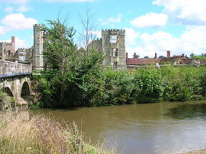
The river's lower section, below Midhurst
Midhurst
Midhurst is a market town and civil parish in the Chichester district of West Sussex, England, with a population of 4,889 in 2001. The town is situated on the River Rother and is home to the ruin of the Tudor Cowdray House and the stately Victorian Cowdray Park...
, was made navigable by the construction of the Western Rother Navigation which was part navigation and part canal, in 1794. The Rother Navigation rose 86 feet (26.2 m) from Stopham to Midhurst by a series of eight locks. A branch connected it to Petworth
Petworth
Petworth is a small town and civil parish in the Chichester District of West Sussex, England. It is located at the junction of the A272 east-west road from Heathfield to Winchester and the A283 Milford to Shoreham-by-Sea road. Some twelve miles to the south west of Petworth along the A285 road...
by the short Petworth Canal
Petworth Canal
The Petworth Canal was one of Britain's shorter lasting canals, opened in 1795 and dismantled in 1826. On completion of the Rother Navigation the Earl of Egremont used his estate workforce to build the 1¼ mile long canal from just upstream of the Shopham Cut to Haslingbourne, with two locks, each...
, 1.25 miles (2 km) long with two locks before terminating at Haslingbourne to the south of the town. The navigation was closed to trade in 1888, being formally abandoned in 1936.
The river is partially fed by springs in the scarp
Escarpment
An escarpment is a steep slope or long cliff that occurs from erosion or faulting and separates two relatively level areas of differing elevations.-Description and variants:...
slope of the chalk
Chalk
Chalk is a soft, white, porous sedimentary rock, a form of limestone composed of the mineral calcite. Calcite is calcium carbonate or CaCO3. It forms under reasonably deep marine conditions from the gradual accumulation of minute calcite plates shed from micro-organisms called coccolithophores....
strata of the South Downs
South Downs
The South Downs is a range of chalk hills that extends for about across the south-eastern coastal counties of England from the Itchen Valley of Hampshire in the west to Beachy Head, near Eastbourne, East Sussex, in the east. It is bounded on its northern side by a steep escarpment, from whose...
which flow at a constant volume and temperature throughout the year. This gives a more stable summer flow than is found in the upper reaches of the River Arun
River Arun
The Arun is a river in the English county of West Sussex. Its source is a series of small streams in the St Leonard's Forest area, to the east of Horsham...
, which drains more clay
Clay
Clay is a general term including many combinations of one or more clay minerals with traces of metal oxides and organic matter. Geologic clay deposits are mostly composed of phyllosilicate minerals containing variable amounts of water trapped in the mineral structure.- Formation :Clay minerals...
soils. This steady flow powered several watermills along the river. The flour mill at Coultershaw, south of Petworth
Petworth
Petworth is a small town and civil parish in the Chichester District of West Sussex, England. It is located at the junction of the A272 east-west road from Heathfield to Winchester and the A283 Milford to Shoreham-by-Sea road. Some twelve miles to the south west of Petworth along the A285 road...
continued in operation until the 1960s, still partially water powered and collecting imported bread wheat from nearby Petworth railway station, which was then still open for goods only.
Etymology
The river takes its name from Rotherbridge, not the other way round. Rotherbridge is derived from the Anglo-Saxon Redrebruge, meaning cattle bridge, which was also the name of the SaxonAnglo-Saxons
Anglo-Saxon is a term used by historians to designate the Germanic tribes who invaded and settled the south and east of Great Britain beginning in the early 5th century AD, and the period from their creation of the English nation to the Norman conquest. The Anglo-Saxon Era denotes the period of...
Hundred or administrative group of parishes. Before this the river was known as the Scir.
See also
- R H Goodsall, The Arun and Western Rother
- P A L Vine, London's Lost Route to Midhurst The Earl of Egremont's Navigation