
Gerlachov Peak
Encyclopedia
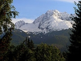
Gerlachovský štít is the highest peak in the High Tatras
, in Slovakia
, and in the whole 1500 km (932.1 mi) long Carpathian
mountain chain, as well as in northern and eastern Central Europe.
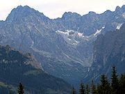
Usually listed at 2,655 metres AMSL (8,711 ft), its exact elevation is actually 0.6 metres (2 ft) lower. The pyramidal shape of the massif is marked by a huge cirque
. Despite its relatively low elevation, the about 2,000 m vertical rise from the valley floor makes Gerlachovský štít soar. Mistaken for an average mountain in the rugged High Tatras
range in the more distant past, it has since played a symbolic role in the eyes of the rulers and populations of several Central European nations, to the point that between the 19th and mid-20th century, it had four different names with six name reversals. It managed to be the highest mountain of the Kingdom of Hungary
, and of the countries of Czechoslovakia
and Slovakia
within the span of only about two decades of the 20th century.
Gerlachovský štít shares its geology and ecology with the rest of the High Tatras
, but provides a worthwhile environment for biologists as the highest ground anywhere in Europe north of the parallel linking approximately Munich
, Salzburg, and Vienna
. The mountain used to be particularly treasured as the loftiest point to climb to by Czechs, eastern Germans, Hungarians, Poles, and Slovaks during the period of restricted travel in the 20th century. It continues to attract its share of visitors although the local authorities have been continually adding new restrictions on access.
". A Slovak
colloquial name is Gerlach. The Polish
names are Gerlach or Gierlach, while its Polish
colloquial names are Girlach and Garłuch.
Kösselberg (Cauldron Mountain) on a map from 1762. The Slovak name of the mountain was first recorded as Kotol, also meaning "Cauldron", in 1821. Both names referred to the peak's characteristic cauldron-like cirque
.
The name that became common in travel books and other literature in the 19th century, however, is its current name, linking the mountain to the village of Gerlachov
at its foot. It echoed the oldest known undifferentiated reference to the peaks on or near Gerlachov's municipal lands, Gerlachfalvenses montes (Latin with Hungarian elements for the "Gerlachov Village Mountains"), in a drawing of the High Tatras from 1717. It also paralleled the name Gerlsdorfer Spitze (Gerlachov Peak) used by the first person to identify it as the highest peak in the Tatras in 1838 (see below), which was rendered as gerlachovský chochol (Gerlach crest) in a Slovak version of his report in 1851. Several other mountains in the High Tatras have acquired their names from villages in the foothills.
Once it was determined that the mountain was the highest point in the region, the succession of the authorities that held control over it took an interest in its name and changed it periodically for symbolic reasons. In 1896, as part of Austria-Hungary
, the highest peak of the Carpathians received its first government-sponsored name − after the contemporary head of state Emperor Francis Joseph I
. Guidebooks sometimes did not catch up on these name changes. After the dissolution of the monarchy in 1918, the mountain continued to be known simply as Gerlachovský štít because it belonged to the village of Gerlachov
. The Polish government, claiming the territory of the High Tatras
for Poland, simultaneously called the mountain Szczyt Polski (Polish Peak), but never gained control over it. The new Czechoslovak
government changed the name to Štít legionárov (Legionnaires Peak) in honor of the Czechoslovak Legions
in 1923, but the name was dropped in favor of the earlier Gerlachovský štít in 1932. As a result of the Communist coup d'état in 1948, the mountain was renamed once more − to Stalinov štít (Stalin
Peak) in 1949. Its traditional name Gerlachovský štít was restored yet again a decade later and has remained unchanged through the present.
 Gerlachovský štít was not always considered the highest mountain in the Tatras. After the first official measurement of peaks in the Tatras during the period of the Habsburg Monarchy
in the 18th century, Kriváň
(2,494 m) was considered the highest. Other candidate peaks for the status of the highest mountain at that time were Lomnický štít
(2,633 m) and Ľadový štít (2,627 m). The first person to accurately name Gerlachovský štít as the highest peak was the forester Ľudovít Greiner
in 1838. Greiner's measurement was formally confirmed by an Austrian Army survey party in 1868. However, it was generally accepted only after the Vienna Military Institute for Geography issued a new, authoritative collection of maps of Central Europe in ca. 1875.
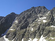
The first confirmed ascent was made by Ján Still from the village of Nová Lesná
in 1834. In 1880, the routes through the Velická próba (Velická Challenge) and Batizovská próba (Batizovská Challenge) were secured by chains.
 Only members of a national UIAA
club are allowed to climb the peak on their own. Other visitors have to take a certified mountain guide. The two easiest routes, usually up the Velická próba and down the Batizovská próba named after their respective valleys, are protected by chains. Because of an exposed section along the Velická próba and tricky orientation especially on the ridge, both are among the more difficult scrambling
routes in the High Tatras, although it's rather climbing, since there are many moments when one must rely on ones hands to hold ones bodyweight. With no snow, guidebooks grade
the routes as a II or III climb (UIAA scale
) or lower. The total elevation gain is about 1,000 m (3,300 ft) for those who spend the night at the Sliezsky Dom Hotel or are driven there by a mountain guide, and about 1,665 m (5,460 ft) for those who hike from Tatranská Polianka
. In winter, Gerlachovský štít offers a challenging alpine climb, with mixed climbing and a risk of avalanches.
The unmarked trailhead is on the green-marked trail leading up Velická Valley near the southern edge of the first plateau (Kvetnica) above the Sliezsky Dom. The equally unmarked, indistinct route to Gerlach veers off north-west towards the mountain's eastern slopes at the elevation of ca. 1,815 m (5,950 ft), but occasional cairns begin to appear farther on. The fastest and easiest descent is down the Batizovská próba. Mountain guides always follow the route in the east-west direction, ascending from Velická Valley and descending into Batizovská Valley, in order to reduce logjams.
Two most popular multi-pitch routes for technical climbing are on the eastern and south-western walls. Both are exceptionally long and situated on solid granite
walls. The best season for climbing is mid September to mid October or until the snow falls. Another good season lasts from late June to early August.
The route to Gerlachovský štít falls under the Tatra National Park
ordinance, according to which hikers who depart from marked trails may be subject to fines unless they are UIAA members, or are led by an IFMGA
-certified mountain guide. Camping is subject to similar restrictions. Rangers and some mountain guides are authorized to collect fines on the spot. Cairns that hikers build to mark the trailhead are periodically taken apart.
may appear at elevations as low as 1,500–2,400 m (4,900–7,900 ft) and it affects the fit and unfit in equal measure, its incidence is reported as lower than 1% even at elevations of 4,600 m (15,000 ft) and has not been reported in the Tatras. Low air pressure begins to have marginal but detectable effects at the summit (2654.4 m; 8,708.7 ft). Water boils at about 91.5 °C (197 °F) and arterial oxygen saturation
is about 8% lower than at most visitors' places of residence, but it is difficult to distinguish slight oxygen deprivation at the summit from fatigue caused by the exertion required to reach it. Authors speak of possible minimal sensory impairment above 1,500 m (4,920 ft). Unlike fitness, age in itself is not a determinant factor in reaching the highest point in the Tatras. The famed Tatra guide Ján Počúvaj took clients to the summit of Gerlach until the age of 76.
in the west to Široká in the north and Lomnický štít
in the east. Farther on, but often visible, are the eastern Low Tatras in the south and part of the Belianske Tatras
in the east. Better than usual visibility, a rare occurrence except in the fall and winter, is needed to see the Stolické vrchy, Volovské vrchy, the Slovak Paradise
region, and Branisko
. Quite exceptionally, visibility may extend to the Austrian Alps
and the Polish–Czech Giant Mountains
hundreds of miles away.
Hikers' reported enjoyment of the view is at least partly attributable to their awareness that they are at the highest point in all of northern and eastern Central Europe. Visibility is merely 10 km (6.2 mi) or less on most summer afternoons because of the amount of water vapor in the air or because of cloudiness (fog). Days with afternoon visibility of 50 km (31.1 mi) or more are common only later in the fall and in winter. The view is partly blocked by the long ridge of Končistá in the west, areas near the mountain towards the south and north are obscured by the Gerlach massif itself. Several other summits in the High Tatras, including some with marked trails, offer more spectacular views with precipitous drops, varied scenery, and encompassing vistas.
 The effects of high-altitude weather on those who ascend Gerlachovský štít may be more pronounced than its altitude alone. The temperature gradient
between the Tatra mountain resorts (900-1,350 m; 2,950–4,430 ft) and the summit can be steep. Low air temperature higher up can be masked by high insolation
under clear skies, but will take its effect with increased cloud cover. Combined with windy conditions, the impact may be considerably detrimental even without rain or snow. The summit disappears in the clouds for periods of time on most days, which translates to fog at that elevation and possible disorientation as well as anxiety.
While temperatures are somewhat lower on Gerlachovský štít because of its elevation, the weather and its potential impact on visitors is little different from other summits in the High Tatras both with and without marked trails. The typical daily weather pattern in the summer is a clear morning, clouds gathering by mid-morning—noon, occasional showers and storms in the afternoon. The chance of rain is lowest between 9–10 am and peaks between 2–3 pm, with a drop-off after 6 pm. The frequency of storms with lightning (as opposed to rainstorms) on Gerlach's summit and on the other highest ridges is little different from lower elevations, too, but people exposed to wind, (sometimes freezing) rain, and lightning have greater difficulty to cope. The nearest shelter for those who ascend Gerlach is the Sliezsky Dom Hotel, there are no natural shelters along the route.
Tatra Mountains
The Tatra Mountains, Tatras or Tatra , are a mountain range which forms a natural border between Slovakia and Poland, and are the highest mountain range in the Carpathian Mountains...
, in Slovakia
Slovakia
The Slovak Republic is a landlocked state in Central Europe. It has a population of over five million and an area of about . Slovakia is bordered by the Czech Republic and Austria to the west, Poland to the north, Ukraine to the east and Hungary to the south...
, and in the whole 1500 km (932.1 mi) long Carpathian
Carpathian Mountains
The Carpathian Mountains or Carpathians are a range of mountains forming an arc roughly long across Central and Eastern Europe, making them the second-longest mountain range in Europe...
mountain chain, as well as in northern and eastern Central Europe.
Usually listed at 2,655 metres AMSL (8,711 ft), its exact elevation is actually 0.6 metres (2 ft) lower. The pyramidal shape of the massif is marked by a huge cirque
Cirque
Cirque may refer to:* Cirque, a geological formation* Makhtesh, an erosional landform found in the Negev desert of Israel and Sinai of Egypt*Cirque , an album by Biosphere* Cirque Corporation, a company that makes touchpads...
. Despite its relatively low elevation, the about 2,000 m vertical rise from the valley floor makes Gerlachovský štít soar. Mistaken for an average mountain in the rugged High Tatras
High Tatras
High Tatras or High Tatra are a mountain range on the borders between Slovakia and Poland. They are a part of the Tatra Mountains...
range in the more distant past, it has since played a symbolic role in the eyes of the rulers and populations of several Central European nations, to the point that between the 19th and mid-20th century, it had four different names with six name reversals. It managed to be the highest mountain of the Kingdom of Hungary
Kingdom of Hungary
The Kingdom of Hungary comprised present-day Hungary, Slovakia and Croatia , Transylvania , Carpatho Ruthenia , Vojvodina , Burgenland , and other smaller territories surrounding present-day Hungary's borders...
, and of the countries of Czechoslovakia
Czechoslovakia
Czechoslovakia or Czecho-Slovakia was a sovereign state in Central Europe which existed from October 1918, when it declared its independence from the Austro-Hungarian Empire, until 1992...
and Slovakia
Slovakia
The Slovak Republic is a landlocked state in Central Europe. It has a population of over five million and an area of about . Slovakia is bordered by the Czech Republic and Austria to the west, Poland to the north, Ukraine to the east and Hungary to the south...
within the span of only about two decades of the 20th century.
Gerlachovský štít shares its geology and ecology with the rest of the High Tatras
Tatra Mountains
The Tatra Mountains, Tatras or Tatra , are a mountain range which forms a natural border between Slovakia and Poland, and are the highest mountain range in the Carpathian Mountains...
, but provides a worthwhile environment for biologists as the highest ground anywhere in Europe north of the parallel linking approximately Munich
Munich
Munich The city's motto is "" . Before 2006, it was "Weltstadt mit Herz" . Its native name, , is derived from the Old High German Munichen, meaning "by the monks' place". The city's name derives from the monks of the Benedictine order who founded the city; hence the monk depicted on the city's coat...
, Salzburg, and Vienna
Vienna
Vienna is the capital and largest city of the Republic of Austria and one of the nine states of Austria. Vienna is Austria's primary city, with a population of about 1.723 million , and is by far the largest city in Austria, as well as its cultural, economic, and political centre...
. The mountain used to be particularly treasured as the loftiest point to climb to by Czechs, eastern Germans, Hungarians, Poles, and Slovaks during the period of restricted travel in the 20th century. It continues to attract its share of visitors although the local authorities have been continually adding new restrictions on access.
Present
Gerlachovský štít means the "Peak (of the village) of GerlachovGerlachov, Poprad District
Gerlachov is a village and municipality in Poprad District in the Prešov Region of northern Slovakia, under the High Tatras. It historically belongs to the Spiš region.-History:In historical records the village was first mentioned in 1326...
". A Slovak
Slovak language
Slovak , is an Indo-European language that belongs to the West Slavic languages .Slovak is the official language of Slovakia, where it is spoken by 5 million people...
colloquial name is Gerlach. The Polish
Polish language
Polish is a language of the Lechitic subgroup of West Slavic languages, used throughout Poland and by Polish minorities in other countries...
names are Gerlach or Gierlach, while its Polish
Polish language
Polish is a language of the Lechitic subgroup of West Slavic languages, used throughout Poland and by Polish minorities in other countries...
colloquial names are Girlach and Garłuch.
Past
The peak's earliest recorded name was the Szepes-GermanCarpathian Germans
Carpathian Germans , sometimes simply called Slovak Germans , are a group of German language speakers on the territory of present-day Slovakia...
Kösselberg (Cauldron Mountain) on a map from 1762. The Slovak name of the mountain was first recorded as Kotol, also meaning "Cauldron", in 1821. Both names referred to the peak's characteristic cauldron-like cirque
Cirque
Cirque may refer to:* Cirque, a geological formation* Makhtesh, an erosional landform found in the Negev desert of Israel and Sinai of Egypt*Cirque , an album by Biosphere* Cirque Corporation, a company that makes touchpads...
.
The name that became common in travel books and other literature in the 19th century, however, is its current name, linking the mountain to the village of Gerlachov
Gerlachov, Poprad District
Gerlachov is a village and municipality in Poprad District in the Prešov Region of northern Slovakia, under the High Tatras. It historically belongs to the Spiš region.-History:In historical records the village was first mentioned in 1326...
at its foot. It echoed the oldest known undifferentiated reference to the peaks on or near Gerlachov's municipal lands, Gerlachfalvenses montes (Latin with Hungarian elements for the "Gerlachov Village Mountains"), in a drawing of the High Tatras from 1717. It also paralleled the name Gerlsdorfer Spitze (Gerlachov Peak) used by the first person to identify it as the highest peak in the Tatras in 1838 (see below), which was rendered as gerlachovský chochol (Gerlach crest) in a Slovak version of his report in 1851. Several other mountains in the High Tatras have acquired their names from villages in the foothills.
Once it was determined that the mountain was the highest point in the region, the succession of the authorities that held control over it took an interest in its name and changed it periodically for symbolic reasons. In 1896, as part of Austria-Hungary
Austria-Hungary
Austria-Hungary , more formally known as the Kingdoms and Lands Represented in the Imperial Council and the Lands of the Holy Hungarian Crown of Saint Stephen, was a constitutional monarchic union between the crowns of the Austrian Empire and the Kingdom of Hungary in...
, the highest peak of the Carpathians received its first government-sponsored name − after the contemporary head of state Emperor Francis Joseph I
Franz Joseph I of Austria
Franz Joseph I or Francis Joseph I was Emperor of Austria, King of Bohemia, King of Croatia, Apostolic King of Hungary, King of Galicia and Lodomeria and Grand Duke of Cracow from 1848 until his death in 1916.In the December of 1848, Emperor Ferdinand I of Austria abdicated the throne as part of...
. Guidebooks sometimes did not catch up on these name changes. After the dissolution of the monarchy in 1918, the mountain continued to be known simply as Gerlachovský štít because it belonged to the village of Gerlachov
Gerlachov, Poprad District
Gerlachov is a village and municipality in Poprad District in the Prešov Region of northern Slovakia, under the High Tatras. It historically belongs to the Spiš region.-History:In historical records the village was first mentioned in 1326...
. The Polish government, claiming the territory of the High Tatras
High Tatras
High Tatras or High Tatra are a mountain range on the borders between Slovakia and Poland. They are a part of the Tatra Mountains...
for Poland, simultaneously called the mountain Szczyt Polski (Polish Peak), but never gained control over it. The new Czechoslovak
Czechoslovakia
Czechoslovakia or Czecho-Slovakia was a sovereign state in Central Europe which existed from October 1918, when it declared its independence from the Austro-Hungarian Empire, until 1992...
government changed the name to Štít legionárov (Legionnaires Peak) in honor of the Czechoslovak Legions
Czechoslovak Legions
The Czechoslovak Legions were volunteer armed forces composed predominantly of Czechs and Slovaks fighting together with the Entente powers during World War I...
in 1923, but the name was dropped in favor of the earlier Gerlachovský štít in 1932. As a result of the Communist coup d'état in 1948, the mountain was renamed once more − to Stalinov štít (Stalin
Joseph Stalin
Joseph Vissarionovich Stalin was the Premier of the Soviet Union from 6 May 1941 to 5 March 1953. He was among the Bolshevik revolutionaries who brought about the October Revolution and had held the position of first General Secretary of the Communist Party of the Soviet Union's Central Committee...
Peak) in 1949. Its traditional name Gerlachovský štít was restored yet again a decade later and has remained unchanged through the present.
History
Habsburg Monarchy
The Habsburg Monarchy covered the territories ruled by the junior Austrian branch of the House of Habsburg , and then by the successor House of Habsburg-Lorraine , between 1526 and 1867/1918. The Imperial capital was Vienna, except from 1583 to 1611, when it was moved to Prague...
in the 18th century, Kriváň
Kriván (peak)
Kriváň is a mountain in the High Tatras, Slovakia, that dominates the upper part of the former Liptov County. Multiple surveys among nature lovers have ranked it as the country's most beautiful peak. Readily accessible along maintained marked trails and with the exceptional vistas afforded from...
(2,494 m) was considered the highest. Other candidate peaks for the status of the highest mountain at that time were Lomnický štít
Lomnický štít
Lomnický štít is one of the highest and most visited mountain peaks in the High Tatras mountains of Slovakia. Connected by cable car to Tatranská Lomnica, its summit is 2634 metres above sea level, making it the second highest peak in the High Tatras after Gerlachovský štít.The first ascent was...
(2,633 m) and Ľadový štít (2,627 m). The first person to accurately name Gerlachovský štít as the highest peak was the forester Ľudovít Greiner
Ludwig Greiner
Ludwig Greiner was an influential 19th-century forest and lumber industry management expert who improved the effectiveness of woodland valuation methods in the Austrian Empire and trained a whole new generation of foresters in a comprehensive approach to the management of natural resources...
in 1838. Greiner's measurement was formally confirmed by an Austrian Army survey party in 1868. However, it was generally accepted only after the Vienna Military Institute for Geography issued a new, authoritative collection of maps of Central Europe in ca. 1875.
The first confirmed ascent was made by Ján Still from the village of Nová Lesná
Nová Lesná
Nová Lesná is a village and municipality in Poprad District in the Prešov Region of northern Slovakia.-Geography:The municipality lies at an altitude of 747 metres and covers an area of 4.159km². It has a population of about 1520 people.-External links:...
in 1834. In 1880, the routes through the Velická próba (Velická Challenge) and Batizovská próba (Batizovská Challenge) were secured by chains.
Access
Union Internationale des Associations d'Alpinisme
The UIAA or Union Internationale des Associations d'Alpinisme, is the organization that represents several million mountaineers and climbers, world-wide, on international issues. Formed in 1932 in Chamonix, France, it now has over 88 members associations from some 76 countries, all of national...
club are allowed to climb the peak on their own. Other visitors have to take a certified mountain guide. The two easiest routes, usually up the Velická próba and down the Batizovská próba named after their respective valleys, are protected by chains. Because of an exposed section along the Velická próba and tricky orientation especially on the ridge, both are among the more difficult scrambling
Scrambling
Scrambling is a method of ascending rocky faces and ridges. It is an ambiguous term that lies somewhere between hillwalking and rock climbing. It is often distinguished from hillwalking by defining a scramble as a route where hands must be used in the ascent...
routes in the High Tatras, although it's rather climbing, since there are many moments when one must rely on ones hands to hold ones bodyweight. With no snow, guidebooks grade
Grade (climbing)
In rock climbing, mountaineering and other climbing disciplines, climbers give a climbing grade to a route that concisely describes the difficulty and danger of climbing the route...
the routes as a II or III climb (UIAA scale
Grade (climbing)
In rock climbing, mountaineering and other climbing disciplines, climbers give a climbing grade to a route that concisely describes the difficulty and danger of climbing the route...
) or lower. The total elevation gain is about 1,000 m (3,300 ft) for those who spend the night at the Sliezsky Dom Hotel or are driven there by a mountain guide, and about 1,665 m (5,460 ft) for those who hike from Tatranská Polianka
Vysoké Tatry (town)
Vysoké Tatry , informally Mesto Vysoké Tatry , is a town at the feet of the Slovak part of High Tatras in Slovakia including all the major resorts in that region...
. In winter, Gerlachovský štít offers a challenging alpine climb, with mixed climbing and a risk of avalanches.
The unmarked trailhead is on the green-marked trail leading up Velická Valley near the southern edge of the first plateau (Kvetnica) above the Sliezsky Dom. The equally unmarked, indistinct route to Gerlach veers off north-west towards the mountain's eastern slopes at the elevation of ca. 1,815 m (5,950 ft), but occasional cairns begin to appear farther on. The fastest and easiest descent is down the Batizovská próba. Mountain guides always follow the route in the east-west direction, ascending from Velická Valley and descending into Batizovská Valley, in order to reduce logjams.
Two most popular multi-pitch routes for technical climbing are on the eastern and south-western walls. Both are exceptionally long and situated on solid granite
Granite
Granite is a common and widely occurring type of intrusive, felsic, igneous rock. Granite usually has a medium- to coarse-grained texture. Occasionally some individual crystals are larger than the groundmass, in which case the texture is known as porphyritic. A granitic rock with a porphyritic...
walls. The best season for climbing is mid September to mid October or until the snow falls. Another good season lasts from late June to early August.
The route to Gerlachovský štít falls under the Tatra National Park
Tatra National Park, Slovakia
Tatra National Park is one of the nine national parks in Slovakia. It is situated in North Central Slovakia in the Tatra Mountains. The Tatra National Park protects the area of the Western Tatras and the Eastern Tatras .The National Park covers an area of 738 km² , and the buffer zone around the...
ordinance, according to which hikers who depart from marked trails may be subject to fines unless they are UIAA members, or are led by an IFMGA
UIAGM
The Union Internationale des Associations de Guides de Montagnes is the International Federation of Mountain Guides Associations, known alternatively by its French, German and English abbreviations:...
-certified mountain guide. Camping is subject to similar restrictions. Rangers and some mountain guides are authorized to collect fines on the spot. Cairns that hikers build to mark the trailhead are periodically taken apart.
Human response
Although authors estimate that at least some of the manifestations of altitude sicknessAltitude sickness
Altitude sickness—also known as acute mountain sickness , altitude illness, hypobaropathy, or soroche—is a pathological effect of high altitude on humans, caused by acute exposure to low partial pressure of oxygen at high altitude...
may appear at elevations as low as 1,500–2,400 m (4,900–7,900 ft) and it affects the fit and unfit in equal measure, its incidence is reported as lower than 1% even at elevations of 4,600 m (15,000 ft) and has not been reported in the Tatras. Low air pressure begins to have marginal but detectable effects at the summit (2654.4 m; 8,708.7 ft). Water boils at about 91.5 °C (197 °F) and arterial oxygen saturation
Oxygen saturation
Oxygen saturation or dissolved oxygen is a relative measure of the amount of oxygen that is dissolved or carried in a given medium. It can be measured with a dissolved oxygen probe such as an oxygen sensor or an optode in liquid media, usually water.It has particular significance in medicine and...
is about 8% lower than at most visitors' places of residence, but it is difficult to distinguish slight oxygen deprivation at the summit from fatigue caused by the exertion required to reach it. Authors speak of possible minimal sensory impairment above 1,500 m (4,920 ft). Unlike fitness, age in itself is not a determinant factor in reaching the highest point in the Tatras. The famed Tatra guide Ján Počúvaj took clients to the summit of Gerlach until the age of 76.
View
Like a 19th-century comment in a British guidebook, "impressive and picturesque", modern hikers usually appreciate the panoramic view of the highest and many other peaks in the High Tatras, from KriváňKriván (peak)
Kriváň is a mountain in the High Tatras, Slovakia, that dominates the upper part of the former Liptov County. Multiple surveys among nature lovers have ranked it as the country's most beautiful peak. Readily accessible along maintained marked trails and with the exceptional vistas afforded from...
in the west to Široká in the north and Lomnický štít
Lomnický štít
Lomnický štít is one of the highest and most visited mountain peaks in the High Tatras mountains of Slovakia. Connected by cable car to Tatranská Lomnica, its summit is 2634 metres above sea level, making it the second highest peak in the High Tatras after Gerlachovský štít.The first ascent was...
in the east. Farther on, but often visible, are the eastern Low Tatras in the south and part of the Belianske Tatras
Belianske Tatras
Belianske Tatras is a mountain range in the Eastern Tatras in North Central Slovakia. Eastern Tatras are part of the Tatra Mountains, which are part of the Inner Western Carpathians....
in the east. Better than usual visibility, a rare occurrence except in the fall and winter, is needed to see the Stolické vrchy, Volovské vrchy, the Slovak Paradise
Slovak Paradise National Park
Slovak Paradise National Park is one of the nine national parks in Slovakia, situated in East Slovakia. The National Park protects the area of the Slovak Paradise mountain range, which is located in the north of the Slovenské rudohorie Mountains .The National Park covers an area of 197.63 km² ,...
region, and Branisko
Branisko (mountain range)
Branisko is a mountain range in eastern Slovakia, between the Spiš and Šariš regions. It is a 20 km long and 5 km wide mountain range in the north-south direction, belonging to the Fatra-Tatra Area of the Inner Western Carpathians....
. Quite exceptionally, visibility may extend to the Austrian Alps
Eastern Alps
Eastern Alps is the name given to the eastern half of the Alps, usually defined as the area east of the Splügen Pass in eastern Switzerland. North of the Splügen Pass, the Posterior Rhine forms the border, and south of the pass, the Liro river and Lake Como form the boundary line.-Geography:The...
and the Polish–Czech Giant Mountains
Karkonosze
Krkonoše is a mountain range located in the north of the Czech Republic and the south-west of Poland, part of the Sudetes mountain system . The Czech-Polish border, which divides the historic regions of Bohemia and Silesia, runs along the main ridge...
hundreds of miles away.
Hikers' reported enjoyment of the view is at least partly attributable to their awareness that they are at the highest point in all of northern and eastern Central Europe. Visibility is merely 10 km (6.2 mi) or less on most summer afternoons because of the amount of water vapor in the air or because of cloudiness (fog). Days with afternoon visibility of 50 km (31.1 mi) or more are common only later in the fall and in winter. The view is partly blocked by the long ridge of Končistá in the west, areas near the mountain towards the south and north are obscured by the Gerlach massif itself. Several other summits in the High Tatras, including some with marked trails, offer more spectacular views with precipitous drops, varied scenery, and encompassing vistas.
Weather
Temperature gradient
A temperature gradient is a physical quantity that describes in which direction and at what rate the temperature changes the most rapidly around a particular location. The temperature gradient is a dimensional quantity expressed in units of degrees per unit length...
between the Tatra mountain resorts (900-1,350 m; 2,950–4,430 ft) and the summit can be steep. Low air temperature higher up can be masked by high insolation
Insolation
Insolation is a measure of solar radiation energy received on a given surface area in a given time. It is commonly expressed as average irradiance in watts per square meter or kilowatt-hours per square meter per day...
under clear skies, but will take its effect with increased cloud cover. Combined with windy conditions, the impact may be considerably detrimental even without rain or snow. The summit disappears in the clouds for periods of time on most days, which translates to fog at that elevation and possible disorientation as well as anxiety.
While temperatures are somewhat lower on Gerlachovský štít because of its elevation, the weather and its potential impact on visitors is little different from other summits in the High Tatras both with and without marked trails. The typical daily weather pattern in the summer is a clear morning, clouds gathering by mid-morning—noon, occasional showers and storms in the afternoon. The chance of rain is lowest between 9–10 am and peaks between 2–3 pm, with a drop-off after 6 pm. The frequency of storms with lightning (as opposed to rainstorms) on Gerlach's summit and on the other highest ridges is little different from lower elevations, too, but people exposed to wind, (sometimes freezing) rain, and lightning have greater difficulty to cope. The nearest shelter for those who ascend Gerlach is the Sliezsky Dom Hotel, there are no natural shelters along the route.
Climate
| Jan | Feb | Mar | Apr | May | Jun | Jul | Aug | Sep | Oct | Nov | Dec | |
|---|---|---|---|---|---|---|---|---|---|---|---|---|
| Air temperature 2–3 pm, Celsius |
-11 | -11 | -8 | -5 | 0 | 3 | 5 | 5 | 2 | -1 | -6 | -9 |
| Air temperature 2–3 pm, Fahrenheit |
12 | 12 | 17 | 23 | 32 | 37 | 41 | 41 | 36 | 10 | 21 | 16 |
| Precipitation in millimeters |
120 | 120 | 100 | 130 | 120 | 190 | 190 | 140 | 90 | 90 | 130 | 150 |
| Days with storms and lightning | 0 | 0 | 0 | 2 | 5 | 9 | 9 | 6 | 2 | 0 | 0 | 0 |
| Days with summit 10+ min. in clouds (low visibility) |
21 | 20 | 22 | 23 | 26 | 25 | 26 | 24 | 21 | 19 | 21 | 21 |
| Days with rime ice | 19 | 15 | 16 | 16 | 13 | 5 | 4 | 5 | 10 | 11 | 17 | 19 |
| Days with snowfall | 19 | 16 | 18 | 19 | 16 | 9 | 5 | 4 | 6 | 11 | 17 | 19 |
| Days with snow cover >1 cm (0.393700787401575 in) |
31 | 28 | 31 | 30 | 24 | 8 | 4 | 3 | 6 | 15 | 28 | 31 |
| Days with visibility >20 km (12.4 mi) at 2–3 pm |
15 | 12 | 12 | 7 | 3 | 3 | 4 | 5 | 8 | 17 | 15 | 15 |