

Ludwig Greiner
Encyclopedia
Ludwig Greiner was an influential 19th-century forest and lumber industry management expert who improved the effectiveness of woodland valuation methods in the Austrian Empire
and trained a whole new generation of foresters in a comprehensive approach to the management of natural resources. While his goals were defined by a need to run a profitable business, he introduced procedures that replaced previous exploitative, earth-eroding lumbering on Saxe-Coburg's estates with practices that contained aspects of modern ecology. Greiner's insistence on a thorough woodland inventory of his employer's vast, poorly charted lands gave him his enduring recognition outside the field defined by his expertise. His passion for precision, geomatics
, and the outdoors made him the first person to disprove the results of previous measurements and accurately identify Gerlachovský štít as the highest peak in the whole 1,500 km (900 mi.) long Carpathian
mountain range.
in Saxony in 1796. His baptismal name is still spelled Ludwig in German, Polish
, and some Slovak
sources, which was also the name he used in his publications. Most Slovak sources now render his baptismal name as Ľudovít, the Hungarian sources render it as Lajos. Non-specialist sources also mostly misidentify him as a rank-and-file forester. After high school, he took special qualifying tests in forestry and spent several years gaining experinece as forester in Austria and on the Lubomirski estates (administrated by the heirs of Julia Lubomirska
) in Habsburg Galicia in the Łańcut and Lviv
regions, now in Poland
and Ukraine
. He finished his education at the Vienna University of Technology
where he took mathematics, physics, and chemistry in 1824–1826. He then became the director of forest management and timber rafting on Duke Ernest of Saxe-Coburg's estates, from where he was hired by Ernest's brother Ferdinand as the head of forestry and land management of all of his estates.
on 1 April 1828. The estates as a company were headquartered in Vienna
, but its center of operations was at Jelšava where Greiner spent the rest of his life. He married Maria Glósz, with whom he had nine children. Two sons, Hugo and Ludwig, followed in their father's footsteps. After his wife's death in 1857 Greiner married Otilia Szinowitz of Banská Bystrica
, but had no more children. He was buried at the Jelšava cemetery next to his first wife.
where he was a founder of the private Girls' Institute of Education in 1871, the first high school in the Hungarian part of what was then the Austro-Hungarian Empire projected specifically for Slovak female students. Ludwig Greiner Senior's great granddaughter Sibylla Greinerová (b. 1919) became an acknowledged Bratislava
painter of human figures in motion.
 Ferdinand Saxe-Coburg's estates were distributed over areas in present-day Slovakia
and Hungary
. The estate managed from Hrabušice
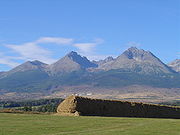
was in the vicinity of the Tatra Mountains
, a craggy section of the Carpathians
. According to Greiner's own account, he climbed Lomnický Peak
on 10 August 1837, a beautiful sunny day, measured its elevation with an altimeter and used the quadrant
to determine that Gerlachovský Peak was actually higher. It was unexpected, because the previous, generally accepted measurement by the Swedish botanist Göran Wahlenberg
from 1813 recorded Gerlachovský Peak's elevation as 285 m (935 ft) lower. Greiner was convinced that his own observation about Gerlachovský Peak's relative height was right, but because he considered the altimeter and quadrant insufficiently precise instruments, he triangulated
the elevations of several of the Tatra peaks from the vicinity of the town of Poprad
, not far from Hrabušice
, in the fall of 1838 after he obtained a very accurate theodolite
from a friend. Greiner's paper published the next year dethroned the mountains of Kriváň
and Lomnický Peak
, which had been alternately considered the highest peaks until then, and reported that the highest point in the Tatras and the whole Carpathian chain was Gerlachovský Peak. The elevation Greiner calculated was off by only 13 meters (43 ft) by comparison to what it is known to be today.
(Kráľova hoľa, 1,946 m, 6,385 ft.) to its natural elevation of 1,650 m (5,413 ft). One of his 21st-century successors described Greiner's principles in modern terms as aiming at and achieving permanent sustainability. Greiner's timber yield tables published in 1877 and 1886 proved sufficiently reliable to have remained in use for over a century.
Austrian Empire
The Austrian Empire was a modern era successor empire, which was centered on what is today's Austria and which officially lasted from 1804 to 1867. It was followed by the Empire of Austria-Hungary, whose proclamation was a diplomatic move that elevated Hungary's status within the Austrian Empire...
and trained a whole new generation of foresters in a comprehensive approach to the management of natural resources. While his goals were defined by a need to run a profitable business, he introduced procedures that replaced previous exploitative, earth-eroding lumbering on Saxe-Coburg's estates with practices that contained aspects of modern ecology. Greiner's insistence on a thorough woodland inventory of his employer's vast, poorly charted lands gave him his enduring recognition outside the field defined by his expertise. His passion for precision, geomatics
Geomatics
Geomatics is the discipline of gathering, storing, processing, and delivering geographic information, or spatially referenced information.-Overview and etymology:...
, and the outdoors made him the first person to disprove the results of previous measurements and accurately identify Gerlachovský štít as the highest peak in the whole 1,500 km (900 mi.) long Carpathian
Carpathian Mountains
The Carpathian Mountains or Carpathians are a range of mountains forming an arc roughly long across Central and Eastern Europe, making them the second-longest mountain range in Europe...
mountain range.
Early life
Greiner was born to the family of the Lutheran pastor Karl Greiner in the small village of LichtentanneLichtentanne
Lichtentanne is a municipality in the district Zwickau, in Saxony, Germany.-Famous people:*Ludwig Greiner, identified Gerlachovský Peak as the summit of the Carpathians...
in Saxony in 1796. His baptismal name is still spelled Ludwig in German, Polish
Polish language
Polish is a language of the Lechitic subgroup of West Slavic languages, used throughout Poland and by Polish minorities in other countries...
, and some Slovak
Slovak language
Slovak , is an Indo-European language that belongs to the West Slavic languages .Slovak is the official language of Slovakia, where it is spoken by 5 million people...
sources, which was also the name he used in his publications. Most Slovak sources now render his baptismal name as Ľudovít, the Hungarian sources render it as Lajos. Non-specialist sources also mostly misidentify him as a rank-and-file forester. After high school, he took special qualifying tests in forestry and spent several years gaining experinece as forester in Austria and on the Lubomirski estates (administrated by the heirs of Julia Lubomirska
Julia Lubomirska (1764-1794)
Princess Julia Lubomirska was a Polish noble lady.She married Jan Nepomucen Potocki on May 9, 1783 in Wilanów....
) in Habsburg Galicia in the Łańcut and Lviv
Lviv
Lviv is a city in western Ukraine. The city is regarded as one of the main cultural centres of today's Ukraine and historically has also been a major Polish and Jewish cultural center, as Poles and Jews were the two main ethnicities of the city until the outbreak of World War II and the following...
regions, now in Poland
Poland
Poland , officially the Republic of Poland , is a country in Central Europe bordered by Germany to the west; the Czech Republic and Slovakia to the south; Ukraine, Belarus and Lithuania to the east; and the Baltic Sea and Kaliningrad Oblast, a Russian exclave, to the north...
and Ukraine
Ukraine
Ukraine is a country in Eastern Europe. It has an area of 603,628 km², making it the second largest contiguous country on the European continent, after Russia...
. He finished his education at the Vienna University of Technology
Vienna University of Technology
Vienna University of Technology is one of the major universities in Vienna, the capital of Austria. Founded in 1815 as the "Imperial-Royal Polytechnic Institute" , it currently has about 26,200 students , 8 faculties and about 4,000 staff members...
where he took mathematics, physics, and chemistry in 1824–1826. He then became the director of forest management and timber rafting on Duke Ernest of Saxe-Coburg's estates, from where he was hired by Ernest's brother Ferdinand as the head of forestry and land management of all of his estates.
Years at Jelšava
Ludwig Greiner started his job at JelšavaJelšava
Jelšava is a town and municipality in Revúca District in the Banská Bystrica Region of Slovakia.-Geography:The town lies in the Revúcka vrchovina highlands at the border of the Slovak Ore Mountains and Slovak Karst, in the valley of the Muráň river, at an altitude of around 258 m...
on 1 April 1828. The estates as a company were headquartered in Vienna
Vienna
Vienna is the capital and largest city of the Republic of Austria and one of the nine states of Austria. Vienna is Austria's primary city, with a population of about 1.723 million , and is by far the largest city in Austria, as well as its cultural, economic, and political centre...
, but its center of operations was at Jelšava where Greiner spent the rest of his life. He married Maria Glósz, with whom he had nine children. Two sons, Hugo and Ludwig, followed in their father's footsteps. After his wife's death in 1857 Greiner married Otilia Szinowitz of Banská Bystrica
Banská Bystrica
Banská Bystrica is a key city in central Slovakia located on the Hron River in a long and wide valley encircled by the mountain chains of the Low Tatras, the Veľká Fatra, and the Kremnica Mountains. With 81,281 inhabitants, Banská Bystrica is the sixth most populous municipality in Slovakia...
, but had no more children. He was buried at the Jelšava cemetery next to his first wife.
Descendants
His son Ludwig Junior became chief engineer at the Coburg-Saxe estates and later forest management director at RožňavaRožnava
Rožňava is a town in Slovakia, approximately 71 km by road from Košice in the Košice Region, and has a population of 19,120.The town is an economic and tourist center of the Gemer. Rožňava is now a popular tourist attraction with a beautiful historic town centre. The town is an episcopal seat...
where he was a founder of the private Girls' Institute of Education in 1871, the first high school in the Hungarian part of what was then the Austro-Hungarian Empire projected specifically for Slovak female students. Ludwig Greiner Senior's great granddaughter Sibylla Greinerová (b. 1919) became an acknowledged Bratislava
Bratislava
Bratislava is the capital of Slovakia and, with a population of about 431,000, also the country's largest city. Bratislava is in southwestern Slovakia on both banks of the Danube River. Bordering Austria and Hungary, it is the only national capital that borders two independent countries.Bratislava...
painter of human figures in motion.
Triangulation of Gerlachovský Peak
Slovakia
The Slovak Republic is a landlocked state in Central Europe. It has a population of over five million and an area of about . Slovakia is bordered by the Czech Republic and Austria to the west, Poland to the north, Ukraine to the east and Hungary to the south...
and Hungary
Hungary
Hungary , officially the Republic of Hungary , is a landlocked country in Central Europe. It is situated in the Carpathian Basin and is bordered by Slovakia to the north, Ukraine and Romania to the east, Serbia and Croatia to the south, Slovenia to the southwest and Austria to the west. The...
. The estate managed from Hrabušice
Hrabušice
Hrabušice is a village and municipality in the Spišská Nová Ves District in the Košice Region of central-eastern Slovakia.-History:The village was first mentioned in local records in 1279. It contains the 13th century Church of St...
was in the vicinity of the Tatra Mountains
Tatra Mountains
The Tatra Mountains, Tatras or Tatra , are a mountain range which forms a natural border between Slovakia and Poland, and are the highest mountain range in the Carpathian Mountains...
, a craggy section of the Carpathians
Carpathian Mountains
The Carpathian Mountains or Carpathians are a range of mountains forming an arc roughly long across Central and Eastern Europe, making them the second-longest mountain range in Europe...
. According to Greiner's own account, he climbed Lomnický Peak
Lomnický štít
Lomnický štít is one of the highest and most visited mountain peaks in the High Tatras mountains of Slovakia. Connected by cable car to Tatranská Lomnica, its summit is 2634 metres above sea level, making it the second highest peak in the High Tatras after Gerlachovský štít.The first ascent was...
on 10 August 1837, a beautiful sunny day, measured its elevation with an altimeter and used the quadrant
Quadrant (instrument)
A quadrant is an instrument that is used to measure angles up to 90°. It was originally proposed by Ptolemy as a better kind of astrolabe. Several different variations of the instrument were later produced by medieval Muslim astronomers.-Types of quadrants:...
to determine that Gerlachovský Peak was actually higher. It was unexpected, because the previous, generally accepted measurement by the Swedish botanist Göran Wahlenberg
Göran Wahlenberg
Georg Wahlenberg was a Swedish naturalist. He was born in Kroppa, Värmland County.Wahlenberg matriculated at Uppsala University in 1792, received his doctorate in Medicine in 1806, was appointed botanices demonstrator in 1814, and professor of medicine and botany in 1829, succeeding Carl Peter...
from 1813 recorded Gerlachovský Peak's elevation as 285 m (935 ft) lower. Greiner was convinced that his own observation about Gerlachovský Peak's relative height was right, but because he considered the altimeter and quadrant insufficiently precise instruments, he triangulated
Triangulation
In trigonometry and geometry, triangulation is the process of determining the location of a point by measuring angles to it from known points at either end of a fixed baseline, rather than measuring distances to the point directly...
the elevations of several of the Tatra peaks from the vicinity of the town of Poprad
Poprad
Poprad is a city in northern Slovakia at the foot of the High Tatra Mountains famous for its picturesque historic centre and as a holiday resort. It is the biggest town of the Spiš region and the tenth largest city in Slovakia with a population of approximately 55,000.The Poprad-Tatry Airport is...
, not far from Hrabušice
Hrabušice
Hrabušice is a village and municipality in the Spišská Nová Ves District in the Košice Region of central-eastern Slovakia.-History:The village was first mentioned in local records in 1279. It contains the 13th century Church of St...
, in the fall of 1838 after he obtained a very accurate theodolite
Theodolite
A theodolite is a precision instrument for measuring angles in the horizontal and vertical planes. Theodolites are mainly used for surveying applications, and have been adapted for specialized purposes in fields like metrology and rocket launch technology...
from a friend. Greiner's paper published the next year dethroned the mountains of Kriváň
Kriván
Kriváň can refer to:* Kriváň , peak in the High Tatras, Slovakia* Veľký Kriváň, the highest peak in Malá Fatra, Slovakia* Malý Kriváň, peak in Malá Fatra, Slovakia* Kriváň , village in Slovakia in the Detva District...
and Lomnický Peak
Lomnický štít
Lomnický štít is one of the highest and most visited mountain peaks in the High Tatras mountains of Slovakia. Connected by cable car to Tatranská Lomnica, its summit is 2634 metres above sea level, making it the second highest peak in the High Tatras after Gerlachovský štít.The first ascent was...
, which had been alternately considered the highest peaks until then, and reported that the highest point in the Tatras and the whole Carpathian chain was Gerlachovský Peak. The elevation Greiner calculated was off by only 13 meters (43 ft) by comparison to what it is known to be today.
Head of forestry and land management
Greiner improved the effectiveness of woodland valuation methods in the Kingdom of Hungary and trained a whole new generation of foresters in a comprehensive approach to the management of natural resources. In 1851 he helped to organize the Hungarian Forestry Association (Ungarischer Forstverein) and then served as its vice president. While his goals were defined by a need to run a profitable business, he introduced procedures that replaced previous exploitative, earth-eroding lumbering on Saxe-Coburg's estates with practices that contained aspects of modern ecology. Among his lasting environmental achievements has been the restoration of the timberline on largely deforested King's Bald MountainKrálova hola
Kráľova hoľa is the highest mountain of the eastern part of the Low Tatras in central Slovakia. Four rivers rise at its foot: Čierny Váh, Hnilec, Hornád, and Hron...
(Kráľova hoľa, 1,946 m, 6,385 ft.) to its natural elevation of 1,650 m (5,413 ft). One of his 21st-century successors described Greiner's principles in modern terms as aiming at and achieving permanent sustainability. Greiner's timber yield tables published in 1877 and 1886 proved sufficiently reliable to have remained in use for over a century.
Publications by Ludwig Greiner
- 1839 − Contributions to the General Knowledge and Improvement of HungarianKingdom of HungaryThe Kingdom of Hungary comprised present-day Hungary, Slovakia and Croatia , Transylvania , Carpatho Ruthenia , Vojvodina , Burgenland , and other smaller territories surrounding present-day Hungary's borders...
Forestry I. (Beiträge zur Kenntnis und Verbesserung des ungarischen Forstwesens in Allgemeinen I.) - 1839 − Gerlachovský Peak as the highest mountain elevation of the CarpathiansCarpathian MountainsThe Carpathian Mountains or Carpathians are a range of mountains forming an arc roughly long across Central and Eastern Europe, making them the second-longest mountain range in Europe...
. ("Die Gerlsdorfer Spitze, als die höchste Gebirgshöhe der Karpathen." Gemeinnützige Blaetter zur Belehrung und Unterhaltung.) - 1843 − Contributions to the General Knowledge and Improvement of HungarianKingdom of HungaryThe Kingdom of Hungary comprised present-day Hungary, Slovakia and Croatia , Transylvania , Carpatho Ruthenia , Vojvodina , Burgenland , and other smaller territories surrounding present-day Hungary's borders...
Forestry II. (Beiträge zur Kenntnis und Verbesserung des ungarischen Forstwesens in Allgemeinen II.) - 1845 − How Could the Very Appreciable Timber Shortage and Forest Loss in our Parts (SpišSpišSpiš is a region in north-eastern Slovakia, with a very small area in south-eastern Poland. Spiš is an informal designation of the territory , but it is also the name of one the 21 official tourism regions of Slovakia...
) Be Most Effectively Remedied? Answered by Ludwig Greiner. (Wodurch könnte dem sehr fühlbaren Holzmangel und der Waldverwüstung in unserer Gegend (Zipsen) am zweckmäßigsten abgeholfen werden? Beantwortet von Ludwig Greiner.)
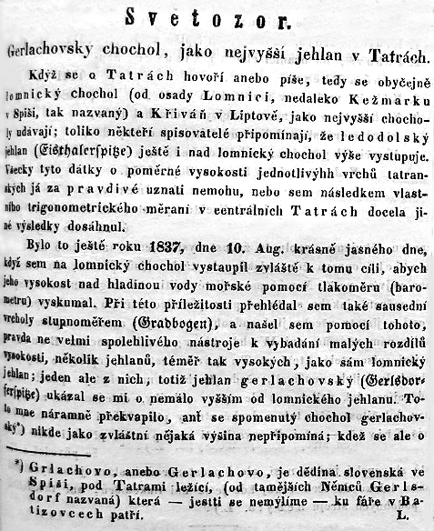
- 1851 − Gerlachovský Crest as the highest peak in the TatrasTatra MountainsThe Tatra Mountains, Tatras or Tatra , are a mountain range which forms a natural border between Slovakia and Poland, and are the highest mountain range in the Carpathian Mountains...
. ("Gerlachovský chochol, jako nejvyšší jehlan v Tatrách." Slovenské noviny.) - 1852 − On the determination of elevations in the CarpathiansCarpathian MountainsThe Carpathian Mountains or Carpathians are a range of mountains forming an arc roughly long across Central and Eastern Europe, making them the second-longest mountain range in Europe...
. ("Über Höhenbestimmungen der Karpathen." Allgemeine Land- und Forstwirtschaftliche Zeitung.) - 1856 − Briefings on the experiences with the most reliable methods of forest stand rejuvenation in high mountains, namely in the Carpathians. ("Mittheilungen der Erfahrungen über die bewährtesten Verjüngungsarten der Bestände im Hochgebirge, namentlich in den Karpathen." Mittheilungen des ungarischen Forstvereines.)
- 1856 − Briefings on the density and conditions of the larchLarchLarches are conifers in the genus Larix, in the family Pinaceae. Growing from 15 to 50m tall, they are native to much of the cooler temperate northern hemisphere, on lowlands in the north and high on mountains further south...
es in the higher CarpathiansCarpathian MountainsThe Carpathian Mountains or Carpathians are a range of mountains forming an arc roughly long across Central and Eastern Europe, making them the second-longest mountain range in Europe...
, in which of those managed forest locations they receded and what are the obstacles to their greater spread. ("Mittheilungen über das Vorkommen und Gedeihen der Lärche in den höheren Karpathen, welche Stelle ihr in dem dort. Forsthaushalte einzuräumen wäre u. welche Hindernisse ihrer grössern Verbreitung entgegen stehen." Mittheilungen des ungarischen Forstvereines.) - 1867 Gemer CountyGemerGemer is the name of a historic administrative county of the Kingdom of Hungary. In the 19th century, and in the beginning of the 20th century, it was united with the Kishont region to form Gömör-Kishont county . Its territory is presently in southern Slovakia and northern Hungary...
forestry dynamics. ("Gömörmegye erdőszeti viszonyai." Erdészeti és gazdászati lapok. In three parts.) - 1873 − Forest Data for the Gemer CountyGemerGemer is the name of a historic administrative county of the Kingdom of Hungary. In the 19th century, and in the beginning of the 20th century, it was united with the Kishont region to form Gömör-Kishont county . Its territory is presently in southern Slovakia and northern Hungary...
Woodlands in Hungary. (Forststatistik der Waldungen des Gömörer Comitates in Ungarn.) - 1873 − Essentials of Forest Valuation Operations and Forest Map Imaging at the Saxe-Coburg Ducal Assets in HungaryKingdom of HungaryThe Kingdom of Hungary comprised present-day Hungary, Slovakia and Croatia , Transylvania , Carpatho Ruthenia , Vojvodina , Burgenland , and other smaller territories surrounding present-day Hungary's borders...
. (Grundzüge zu dem forst-taxationsverfahren und zum zuchnen der forstkarten auf den herzogl. Sachsen- Coburg'schen gütern in Ungarn.) - 1877 − Yield Tables. (Termési táblák. Reissued in 1886.)
- 1882 − A Guideline to the Execution of Timber Yield Management in the High ForestsHigh forest (woodland)High forest is a term for a woodland or forest with a well-developed natural structure. It is used in both ecology and woodland management, particularly in contrast with even-aged woodland types such as coppice and planted woodland....
of the Saxe-Coburg-Gotha Ducal Estates of MuráňMuránMuráň is a village and municipality in Revúca District in the Banská Bystrica Region of Slovakia.-Geography:The village is located around 9 km north of Revúca, in the Muráň river valley. The Muráň Plateau is located north and west of the village, with the governing body of the Muránska planina...
and HrabušiceHrabušiceHrabušice is a village and municipality in the Spišská Nová Ves District in the Košice Region of central-eastern Slovakia.-History:The village was first mentioned in local records in 1279. It contains the 13th century Church of St...
. (Instruktion zur Führung der Forstertrags-Kontrole in den Hochwaldforsten der herzogl. sachsen-coburg-gothaischen Herrschaften Murány und Kapsdorf.)