
Geography of Syria
Encyclopedia
Syria
is located in Southwestern Asia
, north of the Arabian Peninsula
in the Middle East, at the eastern end of the Mediterranean Sea
. It is bordered by Turkey
on the north, Lebanon
and Israel
on the west, Iraq
on the east, and Jordan
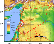
on the south. It consists of mountain ranges in the west and farther inland a steppe area. In the east is the Syrian Desert
and in the south is the Jabal al-Druze Range. The former is bisected by the Euphrates
valley. A dam built in 1973 on the Euphrates created a reservoir named Lake Assad, the largest lake in Syria. The highest point in Syria is Mount Hermon
(2,814 m; 9,232 ft) on the Lebanese border. Between the humid Mediterranean coast and the arid desert regions lies a semiarid steppe zone extending across three-quarters of the country, which receives hot, dry winds blowing across the desert. Syria is extensively run short, with 28 percent of the land arable, 4 percent dedicated to permanent crops, 46 percent utilized as meadows and pastures, and only 3 percent forest and woodland.
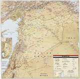
Syria is divided into fourteen governorate
s, or muhafazat (singular: muhafazah
). The governorates are divided into a total of sixty districts, or manatiq (sing. mintaqah), which are further divided into sub-districts, or nawahi (sing. nahiya). The capital Damascus
is the second largest city in Syria, and the metropolitan area is a governorate
on its own. Aleppo
(population 2,301,570) in northern Syria is the largest city. Latakia
along with Tartus are Syria's main ports on the Mediterranean sea.
, covered with sand dunes, is broken only by lateral promontories
running down from the mountains to the sea. Syria claims a territorial limit of 35 nmi (64.8 km; 40.3 mi) off its Mediterranean coastline.
 The Jabal an Nusayriyah
, a mountain range paralleling the coastal plain, has an average elevation of just over 1,212 meters; the highest peak, Nabi Yunis, is about 1,575 meters. The western slopes catch moisture-laden western sea winds and are thus more fertile and more heavily populated than the eastern slopes, which receive only hot, dry winds blowing across the desert. Before reaching the Lebanese border and the Anti-Lebanon
Mountains, the Jabal an Nusayriyah range terminates, leaving a corridor—the Homs Gap—through which run the highway and railroad from Homs
to the Lebanese port of Tripoli
. For centuries the Homs Gap has been a favorite trade and invasion route from the coast to the country's interior and to other parts of Asia. Eastward, the line of al-Ansariyah mountains
is separated from the Jabal az Zawiyah range and the plateau region by the Al Ghab valley, a fertile, irrigated trench crossed by the meandering Orontes River
.
Inland and farther south, the Anti-Lebanon Mountains rise to peaks of over 2,700 meters on the Syrian-Lebanese frontier and spread in spurs eastward toward the plateau region. The eastern slopes have little rainfall and vegetation and merge eventually with the desert.
In the southwest, the lofty Mount Hermon
(Jabal ash Shaykh), also on the border between Syria and Lebanon, descends to the Hawran Plateau—frequently referred to as the Hawran—that receives rain-bearing winds from the Mediterranean. All but the lowest slopes of Mount Hermon are uninhabited, however. Volcanic cones, some of which reach over 900 meters, intersperse the open, rolling, once-fertile Hawran Plateau south of Damascus and east of the Anti-Lebanon Mountains. Southwest of the Hawran lies the high volcanic region of the Jabal al-Druze range (renamed Jabal al Arab), home of the country's Druze
population.
Northeast of the Euphrates, which originates in the mountains of Turkey and flows diagonally across Syria into Iraq, is the fertile Jazira
region. This region is watered by two tributaries to the Euphrates, the Balikh and the Khabur
. The area underwent irrigation improvements during the 1960s and 1970s, and it provides substantial cereal and cotton crops. Oil and natural gas discoveries in the extreme northeastern portion of the Jazira have significantly enhanced the region's economic potential.
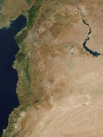 The country's waterways are of vital importance to its agricultural development. The longest and most important river is the Euphrates, which represents more than 80 percent of Syria's water resources. Its main left-bank tributaries, the Balikh and the Khabur, are small perennial rivers that both rise in the Syro-Turkish border region. The right-bank tributaries of the Euphrates are mostly small seasonal streams called wadis. In 1973, Syria completed construction of the Tabqa Dam on the Euphrates River upstream from the town of Ar-Raqqah. The dam created a reservoir named Lake Assad (Buhayrat al Assad), a body of water about 80 kilometers long and averaging eight kilometers in width.
Throughout the arid plateau region east of Damascus, oases, streams, and a few interior rivers that empty into swamps and small lakes provide water for local irrigation. Most important of these is the Barada
, a river that rises in the Anti-Lebanon Mountains and disappears into the desert. The Barada creates the Al Ghutah Oasis, site of Damascus. This verdant area, some 370 square kilometers, has enabled Damascus to prosper since ancient times. In the mid-1980s, the size of Al Ghutah was gradually being eroded as suburban housing and light industry from Damascus encroached on the oasis.
Areas in the Jazira have been brought under cultivation with the waters of the Khabur River (Nahr al Khabur). The Sinn, a minor river in Latakia Governorate
, is used to irrigate the area west of the Jabal an Nusayriyah, about 32 kilometers southwest of the port of Latakia
. In the south the springs that feed the upper Yarmouk River
are diverted for irrigation of the Hawran. Underground water reservoirs that are mainly natural springs are tapped for both irrigation and drinking. The richest in underground water resources is the Al Ghab region, which contains about 19 major springs and underground rivers that have a combined yield of thousands of liters per minute.
Rainfall in this area is fairly abundant, annual precipitation ranging between 750 and 1000 mm (29.5 and 39.4 ). Most of the rain, carried by winds from the Mediterranean, falls between November and May. The annual mean temperatures range from 7 °C (44.6 °F) in January to 27 °C (80.6 °F) in August. Because the high ridges of the Jabal an Nusayriyah catch most of the rains from the Mediterranean, the Al Ghab depression, located east of these mountains, is in a relatively arid zone with warm, dry winds and scanty rainfall. Frost is unknown in any season, although the peaks of the Jabal an Nusayriyah are sometimes snow covered.
Farther south, rain-bearing clouds from the Mediterranean pass through the gap between the Jabal an Nusayriyah and the Anti-Lebanon Mountains, reaching the area of Homs and, sometimes, the steppe region east of that city. Still farther to the south, however, the Anti-Lebanon Mountains bar the rains from the Mediterranean, and the area, including the capital city of Damascus, becomes part of the semiarid climatic zone of the steppe, with precipitation averaging less than 200 millimetres (7.9 in) a year and with temperatures from 4 °C (39.2 °F) in January to 40 °C (104 °F) in July and August. The vicinity of the capital is, nevertheless, verdant and cultivable because of irrigation from the Barada River by aqueducts built during Roman times.
In the southeast, the humidity decreases, and annual precipitation falls below 100 millimetres (3.9 in). The scanty amounts of rain, moreover, are highly variable from year to year, causing periodic droughts. In the barren stony desert south of the Jabal ar Ruwaq, Jabal Abu Rujmayn, and Jabal Bishri ranges, temperatures in July often exceed 45 °C (113 °F). Sandstorms, common during February and May, damage vegetation and prevent grazing. North of the desert ranges and east of the Al Ghab depression lie the vast steppes of the plateau, where cloudless skies and high daytime temperatures prevail during the summer, but frosts, at times severe, are common from November to March. Precipitation averages 250 millimetres (9.8 in) a year but falls below 200 millimetres (7.9 in) in a large belt along the southern desert area. In this belt, only the Euphrates and Khabur rivers provide sufficient water for settlement and cultivation.
petroleum
, phosphate
s, chrome and manganese
ores, textiles, cotton
, asphalt
, iron ore, rock salt, marble
, gypsum
, hydropower
Land use:
arable land:
28%
permanent crops:
4%
permanent pastures:
43%
forests and woodland:
3%
other:
22% (1993 est.)
total:
185,180 km²
land:
184,050 km²
water:
1,130 km²
note: includes 1,295 km² of Israeli-occupied territory
Land boundaries:
total:
2,253 km
border countries:
Iraq
605 km, Israel
76 km, Jordan
375 km, Lebanon
375 km, Turkey
822 km
Coastline:
193 km
Maritime claims:
contiguous zone:
41 nautical miles (75.9 km)
territorial sea:
35 nautical miles (64.8 km)
Elevation extremes:
lowest point:
unnamed location near Lake Tiberias
(Sea of Galilee) -200 m
highest point:
Mount Hermon
2,814 m
dust storms, sandstorms
Environment - current issues:
deforestation; overgrazing; soil erosion; desertification
; water pollution from dumping of raw sewage and wastes from petroleum refining; inadequate supplies of potable water
Environment - international agreements:
party to:
Biodiversity
, Climate Change
, Desertification
, Hazardous Wastes, Nuclear Test Ban, Ozone Layer Protection, Ship Pollution (MARPOL 73/78
), Wetlands
signed, but not ratified:
Environmental Modification
Syria
Syria , officially the Syrian Arab Republic , is a country in Western Asia, bordering Lebanon and the Mediterranean Sea to the West, Turkey to the north, Iraq to the east, Jordan to the south, and Israel to the southwest....
is located in Southwestern Asia
Southwest Asia
Western Asia, West Asia, Southwest Asia or Southwestern Asia are terms that describe the westernmost portion of Asia. The terms are partly coterminous with the Middle East, which describes a geographical position in relation to Western Europe rather than its location within Asia...
, north of the Arabian Peninsula
Arabian Peninsula
The Arabian Peninsula is a land mass situated north-east of Africa. Also known as Arabia or the Arabian subcontinent, it is the world's largest peninsula and covers 3,237,500 km2...
in the Middle East, at the eastern end of the Mediterranean Sea
Mediterranean Sea
The Mediterranean Sea is a sea connected to the Atlantic Ocean surrounded by the Mediterranean region and almost completely enclosed by land: on the north by Anatolia and Europe, on the south by North Africa, and on the east by the Levant...
. It is bordered by Turkey
Turkey
Turkey , known officially as the Republic of Turkey , is a Eurasian country located in Western Asia and in East Thrace in Southeastern Europe...
on the north, Lebanon
Lebanon
Lebanon , officially the Republic of LebanonRepublic of Lebanon is the most common term used by Lebanese government agencies. The term Lebanese Republic, a literal translation of the official Arabic and French names that is not used in today's world. Arabic is the most common language spoken among...
and Israel
Israel
The State of Israel is a parliamentary republic located in the Middle East, along the eastern shore of the Mediterranean Sea...
on the west, Iraq
Iraq
Iraq ; officially the Republic of Iraq is a country in Western Asia spanning most of the northwestern end of the Zagros mountain range, the eastern part of the Syrian Desert and the northern part of the Arabian Desert....
on the east, and Jordan
Jordan
Jordan , officially the Hashemite Kingdom of Jordan , Al-Mamlaka al-Urduniyya al-Hashemiyya) is a kingdom on the East Bank of the River Jordan. The country borders Saudi Arabia to the east and south-east, Iraq to the north-east, Syria to the north and the West Bank and Israel to the west, sharing...
on the south. It consists of mountain ranges in the west and farther inland a steppe area. In the east is the Syrian Desert
Syrian Desert
The Syrian Desert , also known as the Syro-Arabian desert is a combination of steppe and true desert that is located in the northern Arabian Peninsula covering 200,000 square miles . also the desert is very rocky and flat...
and in the south is the Jabal al-Druze Range. The former is bisected by the Euphrates
Euphrates
The Euphrates is the longest and one of the most historically important rivers of Western Asia. Together with the Tigris, it is one of the two defining rivers of Mesopotamia...
valley. A dam built in 1973 on the Euphrates created a reservoir named Lake Assad, the largest lake in Syria. The highest point in Syria is Mount Hermon
Mount Hermon
Mount Hermon is a mountain cluster in the Anti-Lebanon mountain range. Its summit straddles the border between Syria and Lebanon and, at 2,814 m above sea level, is the highest point in Syria. On the top there is “Hermon Hotel”, in the buffer zone between Syria and Israeli-occupied...
(2,814 m; 9,232 ft) on the Lebanese border. Between the humid Mediterranean coast and the arid desert regions lies a semiarid steppe zone extending across three-quarters of the country, which receives hot, dry winds blowing across the desert. Syria is extensively run short, with 28 percent of the land arable, 4 percent dedicated to permanent crops, 46 percent utilized as meadows and pastures, and only 3 percent forest and woodland.
Syria is divided into fourteen governorate
Governorate
A governorate is an administrative division of a country. It is headed by a governor. As English-speaking nations tend to call regions administered by governors either states, provinces, or colonies, the term governorate is often used in translation from non-English-speaking administrations.The...
s, or muhafazat (singular: muhafazah
Muhafazah
A ' is a first-level administrative division of many Arab countries, and a second-level administrative division in Saudi Arabia. The term is usually translated to governorate in English, and occasionally to province. It comes from the Arabic root 'h-f-ẓ' which means to 'keep and guard'...
). The governorates are divided into a total of sixty districts, or manatiq (sing. mintaqah), which are further divided into sub-districts, or nawahi (sing. nahiya). The capital Damascus
Damascus
Damascus , commonly known in Syria as Al Sham , and as the City of Jasmine , is the capital and the second largest city of Syria after Aleppo, both are part of the country's 14 governorates. In addition to being one of the oldest continuously inhabited cities in the world, Damascus is a major...
is the second largest city in Syria, and the metropolitan area is a governorate
Damascus Governorate
Damascus Governorate is one of the 14 governorates of Syria and consists of only the city of Damascus and the suburb of Yarmouk....
on its own. Aleppo
Aleppo
Aleppo is the largest city in Syria and the capital of Aleppo Governorate, the most populous Syrian governorate. With an official population of 2,301,570 , expanding to over 2.5 million in the metropolitan area, it is also one of the largest cities in the Levant...
(population 2,301,570) in northern Syria is the largest city. Latakia
Latakia
Latakia, or Latakiyah , is the principal port city of Syria, as well as the capital of the Latakia Governorate. In addition to serving as a port, the city is a manufacturing center for surrounding agricultural towns and villages...
along with Tartus are Syria's main ports on the Mediterranean sea.
Geographical regions
The area includes about 185,180 square kilometers of deserts, plains, and mountains. It is divided into a coastal zone—with a narrow, double mountain belt enclosing a depression in the west—and a much larger eastern plateau. The climate is predominantly dry; about three-fifths of the country has less than 250 millimetres (9.84 in) of rain a year. Fertile land is the nation's most important natural resource, and efforts have been made, and in the 1980s were continuing, to increase the amount of arable land through irrigation projects.Coastal plain
Along the Mediterranean, a narrow coastal plain stretches south from the Turkish border to Lebanon. The flatness of this littoralLittoral
The littoral zone is that part of a sea, lake or river that is close to the shore. In coastal environments the littoral zone extends from the high water mark, which is rarely inundated, to shoreline areas that are permanently submerged. It always includes this intertidal zone and is often used to...
, covered with sand dunes, is broken only by lateral promontories
Promontory
Promontory may refer to:*Promontory, a prominent mass of land which overlooks lower lying land or a body of water*Promontory, Utah, the location where the United States first Transcontinental Railroad was completed...
running down from the mountains to the sea. Syria claims a territorial limit of 35 nmi (64.8 km; 40.3 mi) off its Mediterranean coastline.
Al-Ansariyah mountains
An-Nusayriyah Mountains also known as al-Alawiyeen Mountains , both names refer to the Alawi sect which has traditionally lived there, and the Syrian official name, Coastal Mountain Range ; are a mountain range in northwestern Syria running north-south, parallel to the coastal plain...
, a mountain range paralleling the coastal plain, has an average elevation of just over 1,212 meters; the highest peak, Nabi Yunis, is about 1,575 meters. The western slopes catch moisture-laden western sea winds and are thus more fertile and more heavily populated than the eastern slopes, which receive only hot, dry winds blowing across the desert. Before reaching the Lebanese border and the Anti-Lebanon
Anti-Lebanon
The Anti-Lebanon mountains is the Western name for the Eastern Lebanon Mountain Range , which are a southwest-northeast-trending mountain range between Syria and Lebanon. Its Western name comes from the Greek word for ‘opposite’. The majority of the mountain range lies in Syria. The border between...
Mountains, the Jabal an Nusayriyah range terminates, leaving a corridor—the Homs Gap—through which run the highway and railroad from Homs
Homs
Homs , previously known as Emesa , is a city in western Syria and the capital of the Homs Governorate. It is above sea level and is located north of Damascus...
to the Lebanese port of Tripoli
Tripoli, Lebanon
Tripoli is the largest city in northern Lebanon and the second-largest city in Lebanon. Situated 85 km north of the capital Beirut, Tripoli is the capital of the North Governorate and the Tripoli District. Geographically located on the east of the Mediterranean, the city's history dates back...
. For centuries the Homs Gap has been a favorite trade and invasion route from the coast to the country's interior and to other parts of Asia. Eastward, the line of al-Ansariyah mountains
Al-Ansariyah mountains
An-Nusayriyah Mountains also known as al-Alawiyeen Mountains , both names refer to the Alawi sect which has traditionally lived there, and the Syrian official name, Coastal Mountain Range ; are a mountain range in northwestern Syria running north-south, parallel to the coastal plain...
is separated from the Jabal az Zawiyah range and the plateau region by the Al Ghab valley, a fertile, irrigated trench crossed by the meandering Orontes River
Orontes River
The Orontes or ‘Āṣī is a river of Lebanon, Syria and Turkey.It was anciently the chief river of the Levant, also called Draco, Typhon and Axius...
.
Inland and farther south, the Anti-Lebanon Mountains rise to peaks of over 2,700 meters on the Syrian-Lebanese frontier and spread in spurs eastward toward the plateau region. The eastern slopes have little rainfall and vegetation and merge eventually with the desert.
In the southwest, the lofty Mount Hermon
Mount Hermon
Mount Hermon is a mountain cluster in the Anti-Lebanon mountain range. Its summit straddles the border between Syria and Lebanon and, at 2,814 m above sea level, is the highest point in Syria. On the top there is “Hermon Hotel”, in the buffer zone between Syria and Israeli-occupied...
(Jabal ash Shaykh), also on the border between Syria and Lebanon, descends to the Hawran Plateau—frequently referred to as the Hawran—that receives rain-bearing winds from the Mediterranean. All but the lowest slopes of Mount Hermon are uninhabited, however. Volcanic cones, some of which reach over 900 meters, intersperse the open, rolling, once-fertile Hawran Plateau south of Damascus and east of the Anti-Lebanon Mountains. Southwest of the Hawran lies the high volcanic region of the Jabal al-Druze range (renamed Jabal al Arab), home of the country's Druze
Druze
The Druze are an esoteric, monotheistic religious community, found primarily in Syria, Lebanon, Israel, and Jordan, which emerged during the 11th century from Ismailism. The Druze have an eclectic set of beliefs that incorporate several elements from Abrahamic religions, Gnosticism, Neoplatonism...
population.
Eastern plateau
The entire eastern plateau region is intersected by a low chain of mountains, the Jabal ar Ruwaq, the Jabal Abu Rujmayn, and the Jabal Bishri, extending northeastward from the Jabal Al Arab to the Euphrates. South of these mountains lies a barren desert region known as the Hamad. North of the Jabal ar Ruwaq and east of the city of Homs is another barren area known as the Homs Desert, which has a hard-packed dirt surface.Northeast of the Euphrates, which originates in the mountains of Turkey and flows diagonally across Syria into Iraq, is the fertile Jazira
Al-Jazira, Mesopotamia
Upper Mesopotamia is the name used for the uplands and great outwash plain of northwestern Iraq and northeastern Syria and southeastern Turkey which is known by the traditional Arabic name of Al-Jazira , variously transliterated into Roman script as Djazirah, Djezirah and Jazirah...
region. This region is watered by two tributaries to the Euphrates, the Balikh and the Khabur
Khabur River
The Khabur River , , , ) is the largest perennial tributary to the Euphrates in Syrian territory. Although the Khabur originates in Turkey, the karstic springs around Ra's al-'Ayn are the river's main source of water. Several important wadis join the Khabur north of Al-Hasakah, together creating...
. The area underwent irrigation improvements during the 1960s and 1970s, and it provides substantial cereal and cotton crops. Oil and natural gas discoveries in the extreme northeastern portion of the Jazira have significantly enhanced the region's economic potential.
Water
Throughout the arid plateau region east of Damascus, oases, streams, and a few interior rivers that empty into swamps and small lakes provide water for local irrigation. Most important of these is the Barada
Barada
The Barada is the main river of Damascus, the capital city of Syria. It flows through the spring of `Ayn Fijah , about 27 km north west of Damascus in the Anti-Lebanon Mountains, but its source is Lake Barada, located at about 8 km from Zabadani...
, a river that rises in the Anti-Lebanon Mountains and disappears into the desert. The Barada creates the Al Ghutah Oasis, site of Damascus. This verdant area, some 370 square kilometers, has enabled Damascus to prosper since ancient times. In the mid-1980s, the size of Al Ghutah was gradually being eroded as suburban housing and light industry from Damascus encroached on the oasis.
Areas in the Jazira have been brought under cultivation with the waters of the Khabur River (Nahr al Khabur). The Sinn, a minor river in Latakia Governorate
Latakia Governorate
Latakia Governorate or muhafazah al Ladhiqiyah is one of the fourteen governorates of Syria. It is situated in western Syria, bordering Turkey. Its reported area varies in different sources from 2,297 km² to 2,437 km² . The Governorate has a population of 991,000 and is one of the...
, is used to irrigate the area west of the Jabal an Nusayriyah, about 32 kilometers southwest of the port of Latakia
Latakia
Latakia, or Latakiyah , is the principal port city of Syria, as well as the capital of the Latakia Governorate. In addition to serving as a port, the city is a manufacturing center for surrounding agricultural towns and villages...
. In the south the springs that feed the upper Yarmouk River
Yarmouk River
The Yarmouk River is the largest tributary of the Jordan River. It drains much of the Hauran Plateau. It is one of three main tributaries which enter the Jordan between the Sea of Galilee and the Dead Sea. To the south, are the Jabbok/Zarqa and the Arnon/Wadi Mujib) rivers...
are diverted for irrigation of the Hawran. Underground water reservoirs that are mainly natural springs are tapped for both irrigation and drinking. The richest in underground water resources is the Al Ghab region, which contains about 19 major springs and underground rivers that have a combined yield of thousands of liters per minute.
Climate
The most striking feature of the climate is the contrast. Between the humid Mediterranean coast and the arid desert regions lies a semiarid steppe zone extending across three-quarters of the country and bordered on the west by the Anti-Lebanon Mountains and the Jabal an Nusayriyah, on the north by the Turkish mountain region, and on the southeast by the Jabal al Arab, Jabal ar Ruwaq, Jabal Abu Rujmayn, and the Jabal Bishri ranges.Rainfall in this area is fairly abundant, annual precipitation ranging between 750 and 1000 mm (29.5 and 39.4 ). Most of the rain, carried by winds from the Mediterranean, falls between November and May. The annual mean temperatures range from 7 °C (44.6 °F) in January to 27 °C (80.6 °F) in August. Because the high ridges of the Jabal an Nusayriyah catch most of the rains from the Mediterranean, the Al Ghab depression, located east of these mountains, is in a relatively arid zone with warm, dry winds and scanty rainfall. Frost is unknown in any season, although the peaks of the Jabal an Nusayriyah are sometimes snow covered.
Farther south, rain-bearing clouds from the Mediterranean pass through the gap between the Jabal an Nusayriyah and the Anti-Lebanon Mountains, reaching the area of Homs and, sometimes, the steppe region east of that city. Still farther to the south, however, the Anti-Lebanon Mountains bar the rains from the Mediterranean, and the area, including the capital city of Damascus, becomes part of the semiarid climatic zone of the steppe, with precipitation averaging less than 200 millimetres (7.9 in) a year and with temperatures from 4 °C (39.2 °F) in January to 40 °C (104 °F) in July and August. The vicinity of the capital is, nevertheless, verdant and cultivable because of irrigation from the Barada River by aqueducts built during Roman times.
In the southeast, the humidity decreases, and annual precipitation falls below 100 millimetres (3.9 in). The scanty amounts of rain, moreover, are highly variable from year to year, causing periodic droughts. In the barren stony desert south of the Jabal ar Ruwaq, Jabal Abu Rujmayn, and Jabal Bishri ranges, temperatures in July often exceed 45 °C (113 °F). Sandstorms, common during February and May, damage vegetation and prevent grazing. North of the desert ranges and east of the Al Ghab depression lie the vast steppes of the plateau, where cloudless skies and high daytime temperatures prevail during the summer, but frosts, at times severe, are common from November to March. Precipitation averages 250 millimetres (9.8 in) a year but falls below 200 millimetres (7.9 in) in a large belt along the southern desert area. In this belt, only the Euphrates and Khabur rivers provide sufficient water for settlement and cultivation.
Resources and land use
Natural resources:petroleum
Petroleum
Petroleum or crude oil is a naturally occurring, flammable liquid consisting of a complex mixture of hydrocarbons of various molecular weights and other liquid organic compounds, that are found in geologic formations beneath the Earth's surface. Petroleum is recovered mostly through oil drilling...
, phosphate
Phosphate
A phosphate, an inorganic chemical, is a salt of phosphoric acid. In organic chemistry, a phosphate, or organophosphate, is an ester of phosphoric acid. Organic phosphates are important in biochemistry and biogeochemistry or ecology. Inorganic phosphates are mined to obtain phosphorus for use in...
s, chrome and manganese
Manganese
Manganese is a chemical element, designated by the symbol Mn. It has the atomic number 25. It is found as a free element in nature , and in many minerals...
ores, textiles, cotton
Cotton
Cotton is a soft, fluffy staple fiber that grows in a boll, or protective capsule, around the seeds of cotton plants of the genus Gossypium. The fiber is almost pure cellulose. The botanical purpose of cotton fiber is to aid in seed dispersal....
, asphalt
Asphalt
Asphalt or , also known as bitumen, is a sticky, black and highly viscous liquid or semi-solid that is present in most crude petroleums and in some natural deposits, it is a substance classed as a pitch...
, iron ore, rock salt, marble
Marble
Marble is a metamorphic rock composed of recrystallized carbonate minerals, most commonly calcite or dolomite.Geologists use the term "marble" to refer to metamorphosed limestone; however stonemasons use the term more broadly to encompass unmetamorphosed limestone.Marble is commonly used for...
, gypsum
Gypsum
Gypsum is a very soft sulfate mineral composed of calcium sulfate dihydrate, with the chemical formula CaSO4·2H2O. It is found in alabaster, a decorative stone used in Ancient Egypt. It is the second softest mineral on the Mohs Hardness Scale...
, hydropower
Hydropower
Hydropower, hydraulic power, hydrokinetic power or water power is power that is derived from the force or energy of falling water, which may be harnessed for useful purposes. Since ancient times, hydropower has been used for irrigation and the operation of various mechanical devices, such as...
Land use:
arable land:
28%
permanent crops:
4%
permanent pastures:
43%
forests and woodland:
3%
other:
22% (1993 est.)
Area and boundaries
Area:total:
185,180 km²
land:
184,050 km²
water:
1,130 km²
note: includes 1,295 km² of Israeli-occupied territory
Land boundaries:
total:
2,253 km
border countries:
Iraq
Iraq
Iraq ; officially the Republic of Iraq is a country in Western Asia spanning most of the northwestern end of the Zagros mountain range, the eastern part of the Syrian Desert and the northern part of the Arabian Desert....
605 km, Israel
Israel
The State of Israel is a parliamentary republic located in the Middle East, along the eastern shore of the Mediterranean Sea...
76 km, Jordan
Jordan
Jordan , officially the Hashemite Kingdom of Jordan , Al-Mamlaka al-Urduniyya al-Hashemiyya) is a kingdom on the East Bank of the River Jordan. The country borders Saudi Arabia to the east and south-east, Iraq to the north-east, Syria to the north and the West Bank and Israel to the west, sharing...
375 km, Lebanon
Lebanon
Lebanon , officially the Republic of LebanonRepublic of Lebanon is the most common term used by Lebanese government agencies. The term Lebanese Republic, a literal translation of the official Arabic and French names that is not used in today's world. Arabic is the most common language spoken among...
375 km, Turkey
Turkey
Turkey , known officially as the Republic of Turkey , is a Eurasian country located in Western Asia and in East Thrace in Southeastern Europe...
822 km
Coastline:
193 km
Maritime claims:
contiguous zone:
41 nautical miles (75.9 km)
territorial sea:
35 nautical miles (64.8 km)
Elevation extremes:
lowest point:
unnamed location near Lake Tiberias
Sea of Galilee
The Sea of Galilee, also Kinneret, Lake of Gennesaret, or Lake Tiberias , is the largest freshwater lake in Israel, and it is approximately in circumference, about long, and wide. The lake has a total area of , and a maximum depth of approximately 43 m...
(Sea of Galilee) -200 m
highest point:
Mount Hermon
Mount Hermon
Mount Hermon is a mountain cluster in the Anti-Lebanon mountain range. Its summit straddles the border between Syria and Lebanon and, at 2,814 m above sea level, is the highest point in Syria. On the top there is “Hermon Hotel”, in the buffer zone between Syria and Israeli-occupied...
2,814 m
Environmental concerns
Natural hazards:dust storms, sandstorms
Environment - current issues:
deforestation; overgrazing; soil erosion; desertification
Desertification
Desertification is the degradation of land in drylands. Caused by a variety of factors, such as climate change and human activities, desertification is one of the most significant global environmental problems.-Definitions:...
; water pollution from dumping of raw sewage and wastes from petroleum refining; inadequate supplies of potable water
Environment - international agreements:
party to:
Biodiversity
Biodiversity
Biodiversity is the degree of variation of life forms within a given ecosystem, biome, or an entire planet. Biodiversity is a measure of the health of ecosystems. Biodiversity is in part a function of climate. In terrestrial habitats, tropical regions are typically rich whereas polar regions...
, Climate Change
United Nations Framework Convention on Climate Change
The United Nations Framework Convention on Climate Change is an international environmental treaty produced at the United Nations Conference on Environment and Development , informally known as the Earth Summit, held in Rio de Janeiro from June 3 to 14, 1992...
, Desertification
Desertification
Desertification is the degradation of land in drylands. Caused by a variety of factors, such as climate change and human activities, desertification is one of the most significant global environmental problems.-Definitions:...
, Hazardous Wastes, Nuclear Test Ban, Ozone Layer Protection, Ship Pollution (MARPOL 73/78
MARPOL 73/78
Marpol 73/78 is the International Convention for the Prevention of Pollution From Ships, 1973 as modified by the Protocol of 1978....
), Wetlands
signed, but not ratified:
Environmental Modification