
Geography of Port Phillip
Encyclopedia
Port Phillip
, sometimes referred to as Port Phillip Bay, is a large bay in southern Victoria
, Australia
, 1,930 km² (476,900 acres) in area, with a coastline length of 264 km (164 mi). The bay is extremely shallow for its size, but mostly navigable. The deepest portion is only 24 m (80 ft), and half the region is shallower than 8 m. Its volume is around 25 km³. The city of Melbourne
is located at its northern end, near the mouth of the Yarra River
.
Port Phillip is home to a vast array of geographic features typically found in bays, such as beach
es, points, island
s and smaller bays, as well as being the drainage point of many major rivers and creeks in Central Victoria. All features here are listed clockwise from the mouth of the Yarra River.

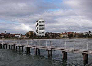
es, most of which are flat, shallow and long, with very small breaks making swimming quite safe. This attracts many tourists, mostly families, to the beaches of Port Phillip during the summer months and school holidays. Water sports such as body boarding and surfing
are difficult or impossible, except in extreme weather conditions. Most sandy beaches are located on the bay's northern, eastern and southern shorelines, while the western shorelines host a few sandy beaches, there mostly exists a greater variety of beaches, swampy wetlands and mangroves. The occasional pebble beach and rocky cliffs can also be found, mostly in the southern reaches. Major beaches include:
Port Phillip
Port Phillip Port Phillip Port Phillip (also commonly referred to as Port Phillip Bay or (locally) just The Bay, is a large bay in southern Victoria, Australia; it is the location of Melbourne. Geographically, the bay covers and the shore stretches roughly . Although it is extremely shallow for...
, sometimes referred to as Port Phillip Bay, is a large bay in southern Victoria
Victoria (Australia)
Victoria is the second most populous state in Australia. Geographically the smallest mainland state, Victoria is bordered by New South Wales, South Australia, and Tasmania on Boundary Islet to the north, west and south respectively....
, Australia
Australia
Australia , officially the Commonwealth of Australia, is a country in the Southern Hemisphere comprising the mainland of the Australian continent, the island of Tasmania, and numerous smaller islands in the Indian and Pacific Oceans. It is the world's sixth-largest country by total area...
, 1,930 km² (476,900 acres) in area, with a coastline length of 264 km (164 mi). The bay is extremely shallow for its size, but mostly navigable. The deepest portion is only 24 m (80 ft), and half the region is shallower than 8 m. Its volume is around 25 km³. The city of Melbourne
Melbourne
Melbourne is the capital and most populous city in the state of Victoria, and the second most populous city in Australia. The Melbourne City Centre is the hub of the greater metropolitan area and the Census statistical division—of which "Melbourne" is the common name. As of June 2009, the greater...
is located at its northern end, near the mouth of the Yarra River
Yarra River
The Yarra River, originally Birrarung, is a river in east-central Victoria, Australia. The lower stretches of the river is where the city of Melbourne was established in 1835 and today Greater Melbourne dominates and influences the landscape of its lower reaches...
.
Port Phillip is home to a vast array of geographic features typically found in bays, such as beach
Beach
A beach is a geological landform along the shoreline of an ocean, sea, lake or river. It usually consists of loose particles which are often composed of rock, such as sand, gravel, shingle, pebbles or cobblestones...
es, points, island
Island
An island or isle is any piece of sub-continental land that is surrounded by water. Very small islands such as emergent land features on atolls can be called islets, cays or keys. An island in a river or lake may be called an eyot , or holm...
s and smaller bays, as well as being the drainage point of many major rivers and creeks in Central Victoria. All features here are listed clockwise from the mouth of the Yarra River.
Beaches
Port Phillip hosts many beachBeach
A beach is a geological landform along the shoreline of an ocean, sea, lake or river. It usually consists of loose particles which are often composed of rock, such as sand, gravel, shingle, pebbles or cobblestones...
es, most of which are flat, shallow and long, with very small breaks making swimming quite safe. This attracts many tourists, mostly families, to the beaches of Port Phillip during the summer months and school holidays. Water sports such as body boarding and surfing
Surfing
Surfing' is a surface water sport in which the surfer rides a surfboard on the crest and face of a wave which is carrying the surfer towards the shore...
are difficult or impossible, except in extreme weather conditions. Most sandy beaches are located on the bay's northern, eastern and southern shorelines, while the western shorelines host a few sandy beaches, there mostly exists a greater variety of beaches, swampy wetlands and mangroves. The occasional pebble beach and rocky cliffs can also be found, mostly in the southern reaches. Major beaches include:
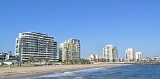
- St Kilda Beach - St KildaSt Kilda, VictoriaSt Kilda is an inner city suburb of Melbourne, Victoria, Australia, 6 km south from Melbourne's central business district. Its Local Government Area is the City of Port Phillip...
- Middle Brighton Beach - BrightonBrighton, VictoriaBrighton is a suburb of Melbourne, Victoria, Australia, 11 km south-east from Melbourne's central business district. Its Local Government Area is the City of Bayside. At the 2006 Census, Brighton had a population of 20,651...
- Sandringham Beach - SandringhamSandringham, VictoriaSandringham is a suburb in Melbourne, Victoria, Australia, 16 km south-east from Melbourne's central business district. Its Local Government Area is the City of Bayside. At the 2006 Census, Sandringham had a population of 8693.-History:...
- Mentone Beach - MentoneMentone, VictoriaMentone is a suburb in Melbourne, Victoria, Australia, 21 km south-east from Melbourne's central business district. Its Local Government Area is the City of Kingston...
- Carrum Beach - CarrumCarrum, VictoriaCarrum is a suburb in Melbourne, Victoria, Australia, south-east from Melbourne's central business district. Its Local Government Area is the City of Kingston...
- Seaford Beach - SeafordSeaford, VictoriaSeaford is a suburb in Melbourne, Victoria, Australia, 36 km south-east from Melbourne's central business district. Its Local Government Area is the City of Frankston...
- Frankston Beach - FrankstonFrankston, VictoriaFrankston is a suburb within the Greater Melbourne metropolitan area in Victoria, Australia. It is located 40 km southeast of the state capital Melbourne at the southernmost edge of Greater Melbourne, near the beginnings of the Mornington Peninsula...
- Mothers Beach - MorningtonMornington, VictoriaMornington is a sea side town on the Mornington Peninsula, Victoria, Australia, located 57 km south-east of Melbourne's central business district. It is in the Local Government Area of the Shire of Mornington Peninsula....
- Safety Beach - Safety BeachSafety Beach, VictoriaSafety Beach is a suburb in Melbourne, Victoria, Australia. Its Local Government Area is the Shire of Mornington Peninsula.Safety Beach occupies slightly less than half the area of land between the foothills of Mount Martha and Arthurs Seat and borders Port Philip Bay to its west.There is a large...
- Dromana Beach - DromanaDromana, VictoriaDromana is a suburb south of Melbourne, the capital city of Victoria, Australia, and is located on the Mornington Peninsula. Its Local Government Area is the Shire of Mornington Peninsula.-Geography:...
- Rosebud Beach - RosebudRosebud, VictoriaRosebud is a sea side town on the Mornington Peninsula, Victoria, Australia located approximately 75 km southeast of the Melbourne City Centre. It is wedged between the lower slopes of Arthurs Seat, the shores of Port Phillip Bay and the plains of Boneo. Its Local Government Area is the...
- Rye Beach - RyeRye, VictoriaRye is a seaside resort town, approximately 83 km south of Melbourne, Victoria, Australia, on the Mornington Peninsula, Victoria, Australia. Its bay beach is popular with swimmers, fishermen, yachtsmen and kitesurfers. Its ocean beach is also popular with surfers...
- Sorrento Front Beach - SorrentoSorrento, VictoriaSorrento is a township in Victoria, Australia, located on the shores of Port Phillip on the Mornington Peninsula, about one and a half hours south of Melbourne...
- Portsea Front Beach - PortseaPortsea, VictoriaPortsea is a resort town located across Port Phillip from Melbourne, Victoria, Australia. Its Local Government Area is the Shire of Mornington Peninsula....
- Queenscliff Beach - QueenscliffQueenscliff, VictoriaQueenscliff is a small town on the Bellarine Peninsula in southern Victoria, Australia, south of Swan Bay at the entrance to Port Phillip. It is the administrative centre for the Borough of Queenscliffe...
- Eastern BeachEastern Beach, VictoriaEastern Beach is a popular swimming and recreation area in Geelong, Victoria on the shores of Corio Bay. Built during the 1930s in the Art Deco style, a shark proof sea bath is provided, as well as a children's swimming pool, kiosk, and dressing room pavilion...
- Geelong - Rippleside Beach - RipplesideRippleside, VictoriaRippleside is a suburb of Geelong, Victoria, Australia. The suburb overlooks Corio Bay.- History :Geelong's early settlers targeted the area which is now Rippleside because of its convenience close to the Melbourne-Geelong Road which runs vertically to Rippleside Park. By 1854 after Geelong...
- Werribee South Beach - Werribee South
- Altona Beach - AltonaAltona, VictoriaAltona is a suburb in Melbourne, Victoria, Australia, 13 km south-west from Melbourne's central business district. Its Local Government Area is the City of Hobsons Bay. At the 2006 Census, Altona had a population of 9685....
- Seaholme Beach - SeaholmeSeaholme, VictoriaSeaholme is a suburb in Melbourne, Victoria, Australia, 13 km south-west from Melbourne's central business district. Its Local Government Area is the City of Hobsons Bay...
- Williamstown Beach - WilliamstownWilliamstown, VictoriaWilliamstown is a suburb in Melbourne, Victoria, Australia, 8 km south-west from Melbourne's central business district. Its Local Government Area is the City of Hobsons Bay. At the 2006 Census, Williamstown had a population of 12,733....
Islands and reefs
- Long Island
- Wooleys Reef
- Pelican Point Reef
- Hovell Pile
- South Channel PileSouth Channel Pile Light, VictoriaThe South Channel Pile Light is a single-storey octagonal lighthouse in Port Phillip, Victoria, Australia. It was built between 1872 and 1874 to guide ships through the narrow South Channel and was occupied by lighthouse keepers until 1925. The light ceased operation in 1985, having operated as a...
(artificial) - South Channel FortSouth Channel FortSouth Channel Fort is a 0.7 ha artificial island in southern Port Phillip, Victoria, Australia, 6 km north-east of the town of Sorrento. It was part of a network of fortifications protecting the narrow entrance to Port Phillip....
- Mud IslandsMud IslandsThe Mud Islands reserve is located within Port Phillip, about 90 km south-west of Melbourne, Australia, lying 10 km inside Port Phillip Heads, 7 km north of Portsea and 9 km east of Queenscliff. The land area of about 50 ha is made up of three low-lying islands surrounding a shallow tidal 35 ha...
- Pope's EyePope's EyePope's Eye is the uncompleted foundation for an island fort intended to defend the entrance to Port Phillip in the state of Victoria, Australia. It is less than a kilometre south-west of the former Chinaman's Hat....
(incomplete fort) - Chinaman's HatChinaman's Hat (Port Phillip)Chinaman's Hat is an octagonal structure serving as a shipping channel marker and haul-out for local Brown fur seals, in the South Channel of Port Phillip, Victoria in the Mornington Peninsula Shire, three kilometers ESE of Pope's Eye...
(artificial) - Nepean ReefPoint Nepean, VictoriaPoint Nepean marks the southern point of The Rip and the most westerly point of the Mornington Peninsula, in Victoria, Australia. It was named after the British politician and colonial administrator, Sir Evan Nepean. It is within the suburb of Portsea...
- Sand Island
- Swan Island
- Stingaree Island
- Mangrove Island
- Rabbit Island
- Tip Island
- Duck IslandDuck Island (Victoria)Duck Island, a small barrier island, lies 1.5 km north of Swan Island and south of Edwards Point in the main entrance to Swan Bay from Port Phillip in southern Victoria, Australia. It is part of the Port Phillip Heads Marine National Park and the plants and animals on and around the island are...
- West Channel Pile
- Mudlands
- Great Sand
- Middle Ground
- South Sand
- Popes Eye Bank
- Middle Sand
- William Sand
- West Sand
Points
- Point Ormond
- Green Point
- Picnic Point (SandinghamSandringham, VictoriaSandringham is a suburb in Melbourne, Victoria, Australia, 16 km south-east from Melbourne's central business district. Its Local Government Area is the City of Bayside. At the 2006 Census, Sandringham had a population of 8693.-History:...
) - Red Bluff
- Quiet Corner
- Ricketts Point
- Table Rock Point
- Olivers Hill
- Pelican Point
- Shnapper Point (MorningtonMornington, VictoriaMornington is a sea side town on the Mornington Peninsula, Victoria, Australia, located 57 km south-east of Melbourne's central business district. It is in the Local Government Area of the Shire of Mornington Peninsula....
) - Linley Point
- Balcombe Point
- Martha Point (Mount MarthaMount Martha, VictoriaMount Martha is a suburb in Melbourne, Victoria, Australia, located 60 km south-east of Melbourne's central business district. Its Local Government Area is the Shire of Mornington Peninsula. It is located on the south-eastern shores of Port Phillip and offers a bathing beach...
) - Anthonys Nose (DromanaDromana, VictoriaDromana is a suburb south of Melbourne, the capital city of Victoria, Australia, and is located on the Mornington Peninsula. Its Local Government Area is the Shire of Mornington Peninsula.-Geography:...
) - White Cliffs
- Eastern Sister
- Western Sister
- Policemans Point (SorrentoSorrento, VictoriaSorrento is a township in Victoria, Australia, located on the shores of Port Phillip on the Mornington Peninsula, about one and a half hours south of Melbourne...
) - Point King
- Point McArthur
- Point Franklin (PortseaPortsea, VictoriaPortsea is a resort town located across Port Phillip from Melbourne, Victoria, Australia. Its Local Government Area is the Shire of Mornington Peninsula....
) - Police Point
- Observatory Point
- Point Nepean
- The RipThe Rip"The Rip", also known as "The Heads", is a dangerous stretch of water in Victoria, Australia, connecting Port Phillip and Bass Strait. It is the only entrance for shipping into Port Phillip and hence into Melbourne. Because of large tidal flows through the relatively narrow channel from the bay to...
- Point Lonsdale
- Shortlands Bluff (QueenscliffQueenscliff, VictoriaQueenscliff is a small town on the Bellarine Peninsula in southern Victoria, Australia, south of Swan Bay at the entrance to Port Phillip. It is the administrative centre for the Borough of Queenscliffe...
) - The Cut
- Swan Point (Swan Island)
- Burnt Point
- Edwards Point
- The Bluff
- Indented Head
- Point George
- Grassy Point
- Point Richards (PortarlingtonPortarlington, VictoriaPortarlington is a historic coastal township located on the Bellarine Peninsula, 27km from the city of Geelong, in the state of Victoria, Australia. The gently rising hills behind the town feature vineyards and olive groves, overlooking Port Phillip Bay. Portarlington is a popular family holiday...
) - Beacon Point
- Point Henry
- Limeburners Point
- Point LilliasPoint LilliasPoint Lillias is a narrow peninsula jutting southwards from the northern coast of Corio Bay, near the city of Geelong, in Victoria, Australia. It was formed by a southward trending tongue of lava from the volcanic flows of the Werribee Plains. The seaward end of the peninsula forms a low cliff...
- Point WilsonPoint Wilson, VictoriaPoint Wilson is a locality located on the northern shores of Corio Bay, Victoria. it is approximately 60 kilometres by road from Melbourne, and 25 kilometres by road from Geelong....
- Kirk Point
- Point Cooke
- Point Gellibrand (WilliamstownWilliamstown, VictoriaWilliamstown is a suburb in Melbourne, Victoria, Australia, 8 km south-west from Melbourne's central business district. Its Local Government Area is the City of Hobsons Bay. At the 2006 Census, Williamstown had a population of 12,733....
)
Bays
- Hobsons BayHobsons BayHobsons Bay is a bay in Port Phillip, Victoria, Australia....
- Greenwich Bay
- Beacon Cove
- Elwood Bay
- Hampton Bay
- Half Moon Bay (Black Rock)
- Watkins Bay
- Beaumaris BayBeaumaris BayBeaumaris Bay is a bay in Port Phillip, Victoria, Australia....
- Keefers Cove
- Daveys BayDaveys BayDaveys Bay is a small shallow bay in Port Phillip, Victoria, Australia. It is one of several small bays adjoining the small town of Mount Eliza and is the closest region of the Shire of Mornington Peninsula to Melbourne....
- Canadian Bay
- Half Moon Bay (Mount Eliza)
- Mornington Bay
- Marina Cover
- Dromana Bay
- Daveys Bay
- Pebble Cove
- Martha Cove
- Capel Sound
- Camerons Bight
- Sullivan Bay
- Sorrento Bay
- Collins Bay
- Weeroona Bay
- Ticonderoga Bay
- Nepean Bay
- The Bend
- The RipThe Rip"The Rip", also known as "The Heads", is a dangerous stretch of water in Victoria, Australia, connecting Port Phillip and Bass Strait. It is the only entrance for shipping into Port Phillip and hence into Melbourne. Because of large tidal flows through the relatively narrow channel from the bay to...
- Lonsdale Bay
- Stingaree Bight
- Swan BaySwan Bay (Victoria)Swan Bay is a shallow, marine embayment at the eastern end of the Bellarine Peninsula in Port Phillip, Victoria, Australia. The township of Queenscliff lies at its southern end, and St Leonards at its northern. It is partly separated from Port Phillip by Swan Island, Duck Island and Edwards Point...
(very shallow at low tide) - Salt Lagoon
- Hood Bight
- Half Moon Bay (Indented Head)
- Outer Harbour
- The Rip
- Corio BayCorio BayCorio Bay is one of numerous bays in the southwest corner of Australia's Port Phillip, and is the bay on which abuts the City of Geelong. The nearby suburb of Corio takes its name from Corio Bay.-Name:...
- Stingaree Bay
- Steampacket Quay
- Corio Quay
- Limeburners' BayLimeburners' BayLimeburners Bay, one of numerous bays in Port Phillip lies in the southwest and adjoins Corio Bay, which abuts Geelong, the second largest city in Victoria, Australia...
- The Spit
- Campbells Cove
- Altona Bay
- Shelley Bay
Confluents
- Yarra RiverYarra RiverThe Yarra River, originally Birrarung, is a river in east-central Victoria, Australia. The lower stretches of the river is where the city of Melbourne was established in 1835 and today Greater Melbourne dominates and influences the landscape of its lower reaches...
- NewportNewport, VictoriaNewport is a suburb in Melbourne, Victoria, Australia, 7 km south-west from Melbourne's central business district. Its Local Government Area is the City of Hobsons Bay. At the 2006 Census, Newport had a population of 11,244.-History:...
/Port Melbourne- Maribyrnong RiverMaribyrnong riverThe Maribyrnong River rises about 50 km north of Melbourne, Victoria , near Mount Macedon. It flows generally southward and combines with the Yarra River to flow into Port Phillip....
- Maribyrnong River
- Sandridge Lagoon (now filled in) - Port Melbourne
- Elster Creek - ElwoodElwood, VictoriaElwood is a suburb in Melbourne, Victoria, Australia, 8 km south from Melbourne's central business district. Its Local Government Area is the City of Port Phillip...
- Mordialloc Creek - Mordialloc
- Patterson RiverPatterson RiverThe Patterson River is a partly man-made waterway located approximately 35km south-east of Melbourne, Australia in Patterson Lakes, Carrum and Bonbeach....
- CarrumCarrum, VictoriaCarrum is a suburb in Melbourne, Victoria, Australia, south-east from Melbourne's central business district. Its Local Government Area is the City of Kingston... - Kananook Creek - FrankstonFrankston, VictoriaFrankston is a suburb within the Greater Melbourne metropolitan area in Victoria, Australia. It is located 40 km southeast of the state capital Melbourne at the southernmost edge of Greater Melbourne, near the beginnings of the Mornington Peninsula...
- Sweetwater CreekSweetwater CreekSweetwater Creek may refer to:* Sweetwater Creek , a novel by Anne Rivers Siddons* Sweetwater Creek, Florida, an unincorporated community in Hillsborough County, Florida* Sweetwater Creek , Georgia...
- Frankston SouthFrankston South, VictoriaFrankston South is a suburb in Melbourne, Victoria, Australia, 43 km south-east from Melbourne's central business district. Its Local Government Area is the City of Frankston... - Kackeraboite Creek - Mount ElizaMount Eliza, VictoriaMount Eliza is an outer suburb south-east of Melbourne, Victoria, Australia. It is in the Local Government Area of the Shire of Mornington Peninsula...
- Ballar Creek - Mount ElizaMount Eliza, VictoriaMount Eliza is an outer suburb south-east of Melbourne, Victoria, Australia. It is in the Local Government Area of the Shire of Mornington Peninsula...
- Earimil Creek - Mount ElizaMount Eliza, VictoriaMount Eliza is an outer suburb south-east of Melbourne, Victoria, Australia. It is in the Local Government Area of the Shire of Mornington Peninsula...
- Gunyong Creek - Mount ElizaMount Eliza, VictoriaMount Eliza is an outer suburb south-east of Melbourne, Victoria, Australia. It is in the Local Government Area of the Shire of Mornington Peninsula...
- Manmangur Creek - Mount ElizaMount Eliza, VictoriaMount Eliza is an outer suburb south-east of Melbourne, Victoria, Australia. It is in the Local Government Area of the Shire of Mornington Peninsula...
- Caraar Creek - MorningtonMornington, VictoriaMornington is a sea side town on the Mornington Peninsula, Victoria, Australia, located 57 km south-east of Melbourne's central business district. It is in the Local Government Area of the Shire of Mornington Peninsula....
- Tanti Creek - MorningtonMornington, VictoriaMornington is a sea side town on the Mornington Peninsula, Victoria, Australia, located 57 km south-east of Melbourne's central business district. It is in the Local Government Area of the Shire of Mornington Peninsula....
- Balcombe Creek - Mount MarthaMount Martha, VictoriaMount Martha is a suburb in Melbourne, Victoria, Australia, located 60 km south-east of Melbourne's central business district. Its Local Government Area is the Shire of Mornington Peninsula. It is located on the south-eastern shores of Port Phillip and offers a bathing beach...
- Hearn Creek - Mount MarthaMount Martha, VictoriaMount Martha is a suburb in Melbourne, Victoria, Australia, located 60 km south-east of Melbourne's central business district. Its Local Government Area is the Shire of Mornington Peninsula. It is located on the south-eastern shores of Port Phillip and offers a bathing beach...
- Tassells Creek - Safety BeachSafety Beach, VictoriaSafety Beach is a suburb in Melbourne, Victoria, Australia. Its Local Government Area is the Shire of Mornington Peninsula.Safety Beach occupies slightly less than half the area of land between the foothills of Mount Martha and Arthurs Seat and borders Port Philip Bay to its west.There is a large...
- Dunns Creek - Safety BeachSafety Beach, VictoriaSafety Beach is a suburb in Melbourne, Victoria, Australia. Its Local Government Area is the Shire of Mornington Peninsula.Safety Beach occupies slightly less than half the area of land between the foothills of Mount Martha and Arthurs Seat and borders Port Philip Bay to its west.There is a large...
- Sheepwash Creek - Safety BeachSafety Beach, VictoriaSafety Beach is a suburb in Melbourne, Victoria, Australia. Its Local Government Area is the Shire of Mornington Peninsula.Safety Beach occupies slightly less than half the area of land between the foothills of Mount Martha and Arthurs Seat and borders Port Philip Bay to its west.There is a large...
- Coburn Creek - McCraeMcCrae, VictoriaMcCrae is a suburb in Melbourne, Victoria, Australia. Its Local Government Area is the Shire of Mornington Peninsula. McCrae is known for the McCrae Lighthouse...
- Chinamans Creek - Rosebud WestRosebud West, VictoriaRosebud West is a suburb in Melbourne, Victoria, Australia. Its Local Government Area is the Shire of Mornington Peninsula.Rosebud West Post Office opened on 12 January 1938 and closed around 1996. -External links:...
- The RipThe Rip"The Rip", also known as "The Heads", is a dangerous stretch of water in Victoria, Australia, connecting Port Phillip and Bass Strait. It is the only entrance for shipping into Port Phillip and hence into Melbourne. Because of large tidal flows through the relatively narrow channel from the bay to...
- Yarram Creek - Swan BaySwan Bay, VictoriaSwan Bay is a bounded rural coastal locality of the City of Greater Geelong between Queenscliff and St Leonards. It is bounded in the west by Portarlington-Queenscliff Road, in the north by Anderson Road, in the east by an offshore line across Swan Bay excluding Swan Island, and in the south by the...
- Frederick Mason Creek - St LeonardsSt Leonards, VictoriaSt Leonards is a coastal township near Geelong, Victoria, Australia, at the eastern end of the Bellarine Peninsula and the northern end of Swan Bay...
- St Leonards Creek - St LeonardsSt Leonards, VictoriaSt Leonards is a coastal township near Geelong, Victoria, Australia, at the eastern end of the Bellarine Peninsula and the northern end of Swan Bay...
- Cowies CreekCowies CreekCowies Creek is a creek in the northern suburbs of Geelong, Victoria, Australia. It flows from wetlands in Moorabool to Corio Quay, Corio Bay in Port Phillip. The mouth of Cowies Creek was excavated to become Corio Quay from 1909, with the creation of Lascelles Wharf to the north in later years....
- North GeelongNorth Geelong, VictoriaNorth Geelong is a suburb of Geelong in the Australian state of Victoria. The suburb will be bypassed by traffic from Melbourne coming from the Princes Freeway by the creation of the Geelong Ring Road, due for completion in 2009.... - Cuthbertson Creek - North ShoreNorth Shore, VictoriaNorth Shore is an industrial and residential suburb of Geelong, Victoria, Australia. The suburb overlooks Corio Bay. A small residential area is east of the North Shore railway station with a few neighbourhood shops....
- Hovell Creek - CorioCorio, VictoriaCorio is a residential, industrial and one of the largest suburbs of Geelong, Victoria, Australia, located approximately 9 km north of the Geelong central business district...
- Little River - Point WilsonPoint Wilson, VictoriaPoint Wilson is a locality located on the northern shores of Corio Bay, Victoria. it is approximately 60 kilometres by road from Melbourne, and 25 kilometres by road from Geelong....
- Werribee RiverWerribee RiverThe Werribee River is located on the plain west of Melbourne, Victoria, Australia. The headwaters of a tributary, the Lerderderg River, are north of Ballan near Daylesford and it flows across the basalt plain, through the suburb of Werribee to enter Port Phillip. A linear park follows the Werribee...
- Cocoroc/Werribee SouthWerribee South, VictoriaWerribee South is a suburb in Melbourne, Victoria, Australia, 32 km south-west from Melbourne's central business district. Its Local Government Area is the City of Wyndham... - Skeleton CreekSkeleton Creek TrailThe Skeleton Creek Trail is a shared use path for cyclists and pedestrians, which follows Skeleton Creek as it passes through the outer western suburb of Point Cook in Melbourne, Victoria, Australia....
- Point CookPoint Cook, VictoriaPoint Cook is a suburb in Melbourne, Victoria, Australia, 25 km south-west from Melbourne's central business district. Its Local Government Area is the City of Wyndham. At the 2006 Census, Point Cook had a population of 14,162, now it is estimated that the population of Point Cook is 32,167... - Laverton CreekLaverton Creek TrailThe Laverton Creek Trail is a shared use path for cyclists and pedestrians, which follows Laverton Creek in the outer western suburbs of Laverton and Altona in Melbourne, Victoria, Australia.The trail is not suitable for roadbikes.-Following the Path:...
- AltonaAltona, VictoriaAltona is a suburb in Melbourne, Victoria, Australia, 13 km south-west from Melbourne's central business district. Its Local Government Area is the City of Hobsons Bay. At the 2006 Census, Altona had a population of 9685.... - Cherry Creek - SeaholmeSeaholme, VictoriaSeaholme is a suburb in Melbourne, Victoria, Australia, 13 km south-west from Melbourne's central business district. Its Local Government Area is the City of Hobsons Bay...
- Kororoit CreekKororoit CreekKororoit Creek is a major waterway of over 80 km in length in the north-west and western parts of Melbourne. Its headwaters are north of Sunbury at 400m above sea level in ordovician geology...
- Williamstown NorthWilliamstown North, VictoriaWilliamstown North is a suburb in Melbourne, Victoria, Australia, 7 km south-west from Melbourne's central business district. Its Local Government Area is the City of Hobsons Bay...
Marine Parks
- Port Phillip Heads Marine National ParkPort Phillip Heads Marine National ParkThe Port Phillip Heads Marine National Park comprises six separate sites, with a combined area of 35.8 km², located in the vicinity of the entrance to Port Phillip, between the Bellarine and Mornington Peninsulas, in Victoria, Australia...