
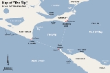
The Rip
Encyclopedia
Victoria (Australia)
Victoria is the second most populous state in Australia. Geographically the smallest mainland state, Victoria is bordered by New South Wales, South Australia, and Tasmania on Boundary Islet to the north, west and south respectively....
, Australia
Australia
Australia , officially the Commonwealth of Australia, is a country in the Southern Hemisphere comprising the mainland of the Australian continent, the island of Tasmania, and numerous smaller islands in the Indian and Pacific Oceans. It is the world's sixth-largest country by total area...
, connecting Port Phillip
Port Phillip
Port Phillip Port Phillip Port Phillip (also commonly referred to as Port Phillip Bay or (locally) just The Bay, is a large bay in southern Victoria, Australia; it is the location of Melbourne. Geographically, the bay covers and the shore stretches roughly . Although it is extremely shallow for...
and Bass Strait
Bass Strait
Bass Strait is a sea strait separating Tasmania from the south of the Australian mainland, specifically the state of Victoria.-Extent:The International Hydrographic Organization defines the limits of the Bass Strait as follows:...
. It is the only entrance for shipping into Port Phillip and hence into Melbourne
Melbourne
Melbourne is the capital and most populous city in the state of Victoria, and the second most populous city in Australia. The Melbourne City Centre is the hub of the greater metropolitan area and the Census statistical division—of which "Melbourne" is the common name. As of June 2009, the greater...
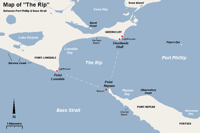
. Because of large tidal flows through the relatively narrow channel from the bay to the ocean, and a high rocky seabed, The Rip has claimed many ships and lives. Geographically, it is the roughly triangular area of water between the land points of Point Nepean, Shortlands Bluff
Queenscliff, Victoria
Queenscliff is a small town on the Bellarine Peninsula in southern Victoria, Australia, south of Swan Bay at the entrance to Port Phillip. It is the administrative centre for the Borough of Queenscliffe...
and Point Lonsdale
Point Lonsdale, Victoria
Point Lonsdale is a coastal township on the Bellarine Peninsula, near Queenscliff, Victoria, Australia, and included in the Borough of Queenscliffe. Point Lonsdale is also one of the headlands which, with Point Nepean, frame The Rip, the entrance to Port Phillip. The headland is dominated by the...
, these 3 form The Heads.
Geography
The rip is generally considered to be located in the triangular area of water between the land points of Point Nepean, Shortlands BluffQueenscliff, Victoria
Queenscliff is a small town on the Bellarine Peninsula in southern Victoria, Australia, south of Swan Bay at the entrance to Port Phillip. It is the administrative centre for the Borough of Queenscliffe...
and Point Lonsdale
Point Lonsdale, Victoria
Point Lonsdale is a coastal township on the Bellarine Peninsula, near Queenscliff, Victoria, Australia, and included in the Borough of Queenscliffe. Point Lonsdale is also one of the headlands which, with Point Nepean, frame The Rip, the entrance to Port Phillip. The headland is dominated by the...
. The entrance between Point Lonsdale and Point Nepean is 3.5 km wide but the reefs projecting from these points reduce the navigable width to about 1 km. Within 800m outside the Heads, there is a shallow rocky flat known as the Rip Bank. The water deepens outside this flat to 30m and inside the Heads to as much as 90 m. This inequality of depth combined with tidal streams running up to 6 knots, causes the world-renowned dangerous conditions. The variation in seafloor depth within the rip itself can be anywhere from 100m to less than 5m amongst the rocky reefs and shoals.
Navigation
Entering the heads of Port Phillip is a risky and dangerous procedure, with many sailors regarding it as one of the most dangerous shipping paths in the world. Control of shipping movements through the heads is managed by the Point Lonsdale Signal StationPoint Lonsdale Lighthouse
Point Lonsdale Lighthouse, also known as the Point Lonsdale Signal Station, is close to the township of Point Lonsdale in the Borough of Queenscliffe, Victoria, Australia...
. Large ships may only enter Port Phillip with a qualified pilot
Maritime pilot
A pilot is a mariner who guides ships through dangerous or congested waters, such as harbours or river mouths. With the exception of the Panama Canal, the pilot is only an advisor, as the captain remains in legal, overriding command of the vessel....
aboard to help them navigate through the heads.
The heads are very narrow, having a width of approximately two kilometres. When entering, large ships have to follow a precise S-shaped course through the heads.
The Queenscliff Low Light
Queenscliff Low Light
The Queenscliff Low Light, also known as the Queenscliff White Lighthouse, is a lighthouse in the township of Queenscliff in the Borough of Queenscliffe, Victoria, Australia, at the eastern end of the Bellarine Peninsula...
("white lighthouse") and Queenscliff High Light ("black lighthouse") form a leading line
Leading lights
Leading lights are a pair of light beacons, used in navigation to indicate a safe passage for vessels entering a shallow or dangerous channel; and may also be used for position fixing. At night, the lights are a form of leading line that can be used for safe navigation...
to guide ships through the main channel, in conjunction with the Hume and Murray Towers that show red and green lights respectively.