

Point Nepean, Victoria
Encyclopedia
The Rip
"The Rip", also known as "The Heads", is a dangerous stretch of water in Victoria, Australia, connecting Port Phillip and Bass Strait. It is the only entrance for shipping into Port Phillip and hence into Melbourne. Because of large tidal flows through the relatively narrow channel from the bay to...
(the entrance to Port Phillip
Port Phillip
Port Phillip Port Phillip Port Phillip (also commonly referred to as Port Phillip Bay or (locally) just The Bay, is a large bay in southern Victoria, Australia; it is the location of Melbourne. Geographically, the bay covers and the shore stretches roughly . Although it is extremely shallow for...
) and the most westerly point of the Mornington Peninsula
Mornington Peninsula
The Mornington Peninsula is a peninsula located south-east of Melbourne in Victoria, Australia. It is surrounded by Port Phillip to the west, Western Port to the east and Bass Strait to the south, and is connected to the mainland in the north. Geographically, the peninsula begins its protrusion...
, in Victoria
Victoria (Australia)
Victoria is the second most populous state in Australia. Geographically the smallest mainland state, Victoria is bordered by New South Wales, South Australia, and Tasmania on Boundary Islet to the north, west and south respectively....
, Australia. It was named after the British politician and colonial administrator, Sir Evan Nepean
Evan Nepean
Sir Evan Nepean, 1st Baronet PC was a British politician and colonial administrator.-Early career:...
. It is within the suburb of Portsea
Portsea, Victoria
Portsea is a resort town located across Port Phillip from Melbourne, Victoria, Australia. Its Local Government Area is the Shire of Mornington Peninsula....
. Its coast and adjacent waters are included in the Port Phillip Heads Marine National Park
Port Phillip Heads Marine National Park
The Port Phillip Heads Marine National Park comprises six separate sites, with a combined area of 35.8 km², located in the vicinity of the entrance to Port Phillip, between the Bellarine and Mornington Peninsulas, in Victoria, Australia...
, while its land area is part of the Point Nepean National Park. Cheviot Beach
Cheviot Beach, Victoria
Cheviot Beach is a beach near Point Nepean in Victoria, Australia. It was named after the SS Cheviot which broke up and sank nearby with the loss of 35 lives on 20 October 1887....
is located on Point Nepean, where the SS Cheviot
SS Cheviot
The SS Cheviot was an iron screw steamer which was wrecked near Point Nepean in Victoria, Australia in 1887, with the loss of 35 lives.-The ship:...
was wrecked in 1887 and Prime Minister of Australia
Prime Minister of Australia
The Prime Minister of the Commonwealth of Australia is the highest minister of the Crown, leader of the Cabinet and Head of Her Majesty's Australian Government, holding office on commission from the Governor-General of Australia. The office of Prime Minister is, in practice, the most powerful...
, Harold Holt
Harold Holt
Harold Edward Holt, CH was an Australian politician and the 17th Prime Minister of Australia.His term as Prime Minister was brought to an early and dramatic end in December 1967 when he disappeared while swimming at Cheviot Beach near Portsea, Victoria, and was presumed drowned.Holt spent 32 years...
, disappeared on 17 December 1967
1967 in Australia
-Incumbents:*Queen of Australia – Elizabeth II*Governor-General – The Lord Casey*Prime Minister – Harold Holt , then John McEwen-State premiers:*Premier of New South Wales – Robert Askin...
, presumed drowned.
History
Evidence of Australian Aboriginal settlement of the area dates back 40,000 years. Point Nepean was a birthing place for women of the Boonerwrung PeopleBunurong
The Bunurong are Indigenous Australians of the Kulin nation, who occupy South-Central Victoria, Australia. Prior to European settlement, they lived as all people of the Kulin nation lived, sustainably on the land, predominantly as hunters and gatherers, for tens of thousands of years...
. There are 70 registered Aboriginal archaeological sites within the Point Nepean National Park.
Limestone was mined from the coastal cliffs from the early days of European settlement and two lime kilns were built around 1840. Point Nepean Quarantine Station was opened in 1852 and is the second oldest intact quarantine station in Australia. It contains the oldest buildings erected for quarantine purposes in Australia, four of the main hospital buildings (established in 1857), pre-dating the oldest intact quarantine-related structures at North Head
Sydney Heads
Sydney Heads , is the entrance to Port Jackson in Sydney, New South Wales, Australia.North Head and Quarantine Head are to the north, South Head and Dunbar Head are to the south. Middle Head, Georges Head and Chowder Head are to the west and within the bay...
, Sydney, by sixteen years. The Quarantine Station operated until 1980.
Point Nepean Post Office opened on 1 April 1859 but was closed by 1865. Fortifications were built from 1878. Gun batteries were installed at Fort Nepean
Fort Nepean
Fort Nepean is a former defensive facility occupying part of Point Nepean, Victoria, Australia. It was part of a network of fortifications, commanded from Fort Queenscliff, protecting the narrow entrance to Port Phillip.- Background :...
in 1886 and Eagles Nest in 1888. A gun battery was constructed at Fort Pearce
Fort Pearce
Fort Pearce is a former defensive facility occupying part of Point Nepean, Victoria, Australia. It was part of a network of fortifications, commanded from Fort Queenscliff, protecting the narrow entrance to Port Phillip.-Fortifications:...
in 1911. With the removal of coastal artillery after World War II, the facilities housed an Officer Cadet School and the School of Army Health from 1951 to 1985.
Land sales
Parts of Point Nepean were declared national park in 1988. The Commonwealth government offered to sell the land to the state of Victoria in 1998 and again in 2001, but the state rejected the offer.In 2002 the Department of Defence proposed selling 311 hectares of land for development, retaining 1.6 hectares which contains contaminated soil and unexploded ordnance. The proposed sale was abandoned in 2003 following strong community protest. In 2004, 90 hectares of Defence land was transferred to the Commonwealth government's Point Nepean Community Trust, which managed the former Quarantine Station until the land was transferred to the Victorian government on 8 June 2009. The Commonwealth also transferred 205 hectares of bushland (former Firing Range area) to Parks Victoria
Parks Victoria
-Department:Parks Victoria was established in December 1996 as a statutory authority, reporting to the Minister for Environment and Climate Change. The Parks Victoria Act 1998 makes Parks Victoria responsible for managing national parks, reserves and other land under the control of the state,...
and the remaining 17.6 hecatres to the Shire of Mornington Peninsula
Shire of Mornington Peninsula
The Shire of Mornington Peninsula is a Local Government Area in Victoria, Australia. It is located to the south of the city of Melbourne on the Mornington Peninsula. It has an area of 723 square kilometres...
for community use.
The former Quarantine Station was opened to the community as part of Point Nepean National Park in December 2009.
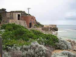
Military ruins
Fort Nepean
Fort Nepean is a former defensive facility occupying part of Point Nepean, Victoria, Australia. It was part of a network of fortifications, commanded from Fort Queenscliff, protecting the narrow entrance to Port Phillip.- Background :...
in 1886 and Eagles Nest in 1888. Barracks were constructed at Fort Pearce. With the removal of coastal artillery after World War II, the facilities housed an Officer Cadet School and the School of Army Health from 1951 to 1985. Some of the historic features include (major features shown in bold):
- Gun Junction — gun barrel ruins and guard house
- Norris Barracks — incorporates buildings from the former Quarantine Station
- 25m rifle range
- Cattle Jetty Ruins (1879) – Observatory Point
- Point Nepean Cemetery (1854–1952)
- Cheviot Hill
- WW2 gun emplacement, battery and observation post
- Machine Gun Emplacement
- Eagles Nest
- Fort PearceFort PearceFort Pearce is a former defensive facility occupying part of Point Nepean, Victoria, Australia. It was part of a network of fortifications, commanded from Fort Queenscliff, protecting the narrow entrance to Port Phillip.-Fortifications:...
- Pearce Barracks
- Gun Emplacements
- Fort NepeanFort NepeanFort Nepean is a former defensive facility occupying part of Point Nepean, Victoria, Australia. It was part of a network of fortifications, commanded from Fort Queenscliff, protecting the narrow entrance to Port Phillip.- Background :...
- Fort Nepean
- Historical retaining wall
- 8 Gun Emplacements
- Engine House
- Historic Gun Barrels
- Underground Tunnels
Environment
The coast of Point Nepean contains intertidal reef platforms with high invertebrate diversity as well as subtidal reefs with diverse communities of fish, invertebrates and encrusting organisms such as ascidians, sponges and bryozoans.External links
- Point Nepean National Park Parks Victoria