

Geography of Oman
Encyclopedia
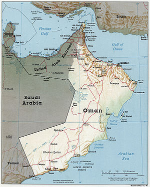
Oman
is a country situated in Southwest Asia
, bordering the Arabian Sea
, Gulf of Oman
, and Persian Gulf
, between Yemen
and United Arab Emirates
(UAE).
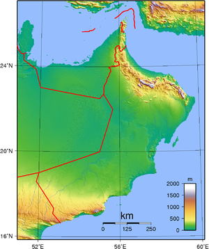
and covers a total land area of 309,500 square kilometers. The land area is composed of varying topographic
features: valley
s and desert
account for 82 percent of the land mass; mountain ranges, 15 percent; and the coastal plain, 3 percent.
The sultanate is flanked by the Gulf of Oman
, the Arabian Sea
, and the Rub' al Khali (Empty Quarter) of Saudi Arabia
, all of which contributed to Oman's isolation. Historically, the country's contacts with the rest of the world were by sea, which not only provided access to foreign lands but also linked the coastal towns of Oman
. The Rub al Khali, difficult to cross even with modern desert transport, formed a barrier between the sultanate and the Arabian interior. The Al Hajar Mountains
, which form a belt between the coast and the desert from the Musandam Peninsula (Ras Musandam) to the city of Sur
at Oman's easternmost point, formed another barrier. These geographic barriers kept the interior of Oman free from foreign military encroachments.
Geographic coordinates:
21°00′N 57°00′E
 Natural features divide the country into seven distinct areas: Ruus al Jibal, including the northern Musandam Peninsula; the Al Batinah
plain running southeast along the Gulf of Oman coast; the Oman interior behind the Al Batinah coast comprising the Al Hajar Mountains
their foothills, and desert fringes; the coast from Muscat
-Matrah
around the Ras al Hadd point and down the Arabian Sea
; the offshore island of Masirah; and finally the barren coastline south to the Dhofar
region in the south.
Except for the foggy and fertile Dhofar all of the coast and the lowlands around the Al Hajar mountains are part of the Gulf of Oman desert and semi-desert
ecoregion, while the mountains themselves are a distinct habitat.
(UAE) at Hisn al Diba. It borders the Strait of Hormuz
, which links the Persian Gulf
with the Gulf of Oman
, and is separated from the rest of the sultanate by a strip of territory belonging to the UAE. This area consists of low mountains forming the northernmost extremity of the Al Hajar al Gharbi (Western Al Hajar) Mountains. Two inlets, Elphinstone (Khawr ash Shamm) and Malcom (Ghubbat al Ghazirah), cleave the coastline about one third of the distance from the Strait of Hormuz
and at one point are separated by only a few hundred meters of land. The coastline is extremely rugged, and the Elphinstone Inlet, sixteen kilometers long and surrounded by cliffs 1,000 to 1,250 meters high, has frequently been compared with fjord
s in Norway
.
. A narrow, well-populated coastal plain known as Al Batinah runs from the point at which the sultanate is reentered to the town of As Sib, about 140 kilometers to the southeast. Across the plains, a number of wadi
s, heavily populated in their upper courses, descend from the Al Hajar al Gharbi Mountains to the south. A ribbon of oases, watered by wells and underground channels (falaj), extends the length of the plain, about ten kilometers inland.
and Matrah
, where natural harbors facilitated the growth of cities centuries ago.
(Green Mountain), rise to more than 3,000 m. Jabal Akhdar is the only home of the Arabian tahr
, a unique species of wild goat. In the hope of saving this rare animal, Sultan Qabus ibn Said has declared part of the mountain a national park. Behind the Al Hajar al Gharbi Mountains are two inland regions, Az Zahirah and Inner Oman, separated by the lateral range of the Rub al Khali. Adjoining the Al Hajar ash Sharqi Mountains are the sandy regions of Ash Sharqiyah and Jalan, which also border the desert.
, was the permanent residence of Sultan Said ibn Taimur Al Said and the birthplace of the present sultan, Qabus ibn Said. The highest peaks are about 2,000 meters. The coast of Dhofar is fertile, being watered by monsoonal fogs from the Indian Ocean and is part of the Arabian Peninsula coastal fog desert
ecoregion
.
Al Dharerah region consists of three parts:Dhank; Ibri; and Yanqul.
 With the exception of Dhofar
region, which has a strong monsoon climate and receives warm winds from the Indian Ocean, the climate of Oman is extremely hot and dry most of the year.
Summer begins in mid-April and lasts until October. The highest temperatures are registered in the interior, where readings of more than 53 °C (127.4 °F) in the shade are common. On the Al Batinah plain, summer temperatures seldom exceed 47 °C (116.6 °F), but, because of the low elevation, the humidity may be as high as 90 percent. The mean summer temperature in Muscat
is 33 °C (91.4 °F), but the gharbi (literally, western), a strong wind that blows from the Rub al Khali, can raise temperatures from the towns on the Gulf of Oman by 6 C-change to 10 C-change.
Winter temperatures are mild and pleasant, ranging between 18 and 26 °C (64.4 and 78.8 F).
Precipitation
on the coasts and on the interior plains ranges from 20 to 100 mm (0.78740157480315 to 3.9 in) a year and falls during mid- and late winter. Rainfall in the mountains, particularly over Jebel Akhdar
, is much higher and may reach 900 millimetres (35.4 in).
Because the plateau
of Jebel Akhdar is porous limestone, rainfall seeps quickly through it, and the vegetation, which might be expected to be more lush, is meager. However, a huge reservoir under the plateau provides springs for low-lying areas. In addition, an enormous wadi
channels water to these valleys, making the area agriculturally productive in years of good rainfall.
Dhofar
, benefiting from a southwest monsoon
between June and September, receives heavier rainfall and has constantly running streams, which make the region Oman's most fertile area.
Occasionally, a cyclone from the North Indian Ocean makes landfall, bringing with it heavy rain, such as Cyclone Kelia did in 2011. Oman was hit by Cyclone Gonu
on June 6. Large areas in the capital area region in the Governorate of Muscat and in Amerat and Quriyat
were severely affected. Gonu first hit the southern city of Sur late on June 5, 2007. Oman is one of the few countries with no National Red Crescent or Red Cross Society.
Border countries: Saudi Arabia
676 km, United Arab Emirates
410 km, Yemen
288 km
Coastline: 2,092 km
Maritime claims:
Island territory: Khuriya Muriya Islands
, Masirah Island
petroleum
, copper
, asbestos
, some marble
, limestone
, chromium
, gypsum
, natural gas
, frankincense
Land use:
Irrigated land:
580 km² (1993 est.)
Environment - current issues: Soil salinity is rising. There is beach pollution from oil spills. There are very limited natural fresh water resources
Geographical note: Oman is in a strategic location on Musandam Peninsula adjacent to Strait of Hormuz
, a vital transit point for world crude oil
Oman
Oman , officially called the Sultanate of Oman , is an Arab state in southwest Asia on the southeast coast of the Arabian Peninsula. It is bordered by the United Arab Emirates to the northwest, Saudi Arabia to the west, and Yemen to the southwest. The coast is formed by the Arabian Sea on the...
is a country situated in Southwest Asia
Southwest Asia
Western Asia, West Asia, Southwest Asia or Southwestern Asia are terms that describe the westernmost portion of Asia. The terms are partly coterminous with the Middle East, which describes a geographical position in relation to Western Europe rather than its location within Asia...
, bordering the Arabian Sea
Arabian Sea
The Arabian Sea is a region of the Indian Ocean bounded on the east by India, on the north by Pakistan and Iran, on the west by the Arabian Peninsula, on the south, approximately, by a line between Cape Guardafui in northeastern Somalia and Kanyakumari in India...
, Gulf of Oman
Gulf of Oman
The Gulf of Oman or Sea of Oman is a strait that connects the Arabian Sea with the Strait of Hormuz, which then runs to the Persian Gulf. It is generally included as a branch of the Persian Gulf, not as an arm of the Arabian Sea. On the north coast is Pakistan and Iran...
, and Persian Gulf
Persian Gulf
The Persian Gulf, in Southwest Asia, is an extension of the Indian Ocean located between Iran and the Arabian Peninsula.The Persian Gulf was the focus of the 1980–1988 Iran-Iraq War, in which each side attacked the other's oil tankers...
, between Yemen
Yemen
The Republic of Yemen , commonly known as Yemen , is a country located in the Middle East, occupying the southwestern to southern end of the Arabian Peninsula. It is bordered by Saudi Arabia to the north, the Red Sea to the west, and Oman to the east....
and United Arab Emirates
United Arab Emirates
The United Arab Emirates, abbreviated as the UAE, or shortened to "the Emirates", is a state situated in the southeast of the Arabian Peninsula in Western Asia on the Persian Gulf, bordering Oman, and Saudi Arabia, and sharing sea borders with Iraq, Kuwait, Bahrain, Qatar, and Iran.The UAE is a...
(UAE).
Location
Oman is located in the southeastern quarter of the Arabian PeninsulaArabian Peninsula
The Arabian Peninsula is a land mass situated north-east of Africa. Also known as Arabia or the Arabian subcontinent, it is the world's largest peninsula and covers 3,237,500 km2...
and covers a total land area of 309,500 square kilometers. The land area is composed of varying topographic
Topography
Topography is the study of Earth's surface shape and features or those ofplanets, moons, and asteroids...
features: valley
Valley
In geology, a valley or dale is a depression with predominant extent in one direction. A very deep river valley may be called a canyon or gorge.The terms U-shaped and V-shaped are descriptive terms of geography to characterize the form of valleys...
s and desert
Desert
A desert is a landscape or region that receives an extremely low amount of precipitation, less than enough to support growth of most plants. Most deserts have an average annual precipitation of less than...
account for 82 percent of the land mass; mountain ranges, 15 percent; and the coastal plain, 3 percent.
The sultanate is flanked by the Gulf of Oman
Gulf of Oman
The Gulf of Oman or Sea of Oman is a strait that connects the Arabian Sea with the Strait of Hormuz, which then runs to the Persian Gulf. It is generally included as a branch of the Persian Gulf, not as an arm of the Arabian Sea. On the north coast is Pakistan and Iran...
, the Arabian Sea
Arabian Sea
The Arabian Sea is a region of the Indian Ocean bounded on the east by India, on the north by Pakistan and Iran, on the west by the Arabian Peninsula, on the south, approximately, by a line between Cape Guardafui in northeastern Somalia and Kanyakumari in India...
, and the Rub' al Khali (Empty Quarter) of Saudi Arabia
Saudi Arabia
The Kingdom of Saudi Arabia , commonly known in British English as Saudi Arabia and in Arabic as as-Sa‘ūdiyyah , is the largest state in Western Asia by land area, constituting the bulk of the Arabian Peninsula, and the second-largest in the Arab World...
, all of which contributed to Oman's isolation. Historically, the country's contacts with the rest of the world were by sea, which not only provided access to foreign lands but also linked the coastal towns of Oman
Oman
Oman , officially called the Sultanate of Oman , is an Arab state in southwest Asia on the southeast coast of the Arabian Peninsula. It is bordered by the United Arab Emirates to the northwest, Saudi Arabia to the west, and Yemen to the southwest. The coast is formed by the Arabian Sea on the...
. The Rub al Khali, difficult to cross even with modern desert transport, formed a barrier between the sultanate and the Arabian interior. The Al Hajar Mountains
Al Hajar Mountains
The Hajjar Mountains in northeastern Oman and also the eastern United Arab Emirates are the highest mountain range in the eastern Arabian peninsula...
, which form a belt between the coast and the desert from the Musandam Peninsula (Ras Musandam) to the city of Sur
Sur, Oman
Sur is a capital city of Ash Sharqiyah Region, northeastern Oman, on the coast of the Gulf of Oman. It is located at around , and is 93 miles southeast of the Omani capital Muscat. Historically the city is known for being an important destination point for sailors...
at Oman's easternmost point, formed another barrier. These geographic barriers kept the interior of Oman free from foreign military encroachments.
Geographic coordinates:
21°00′N 57°00′E
Geographical regions
Al Batinah Region
Al Bāţinah is one of the regions of Oman.Al Batinah Region, otherwise known as Al Batinah, occupies an important location on the coast of Gulf of Oman. It lies between Khatmat Malahah in the north and Ras AL Hamra in the south and confined between the Al Hajar Mountains in the west and the Gulf...
plain running southeast along the Gulf of Oman coast; the Oman interior behind the Al Batinah coast comprising the Al Hajar Mountains
Al Hajar Mountains
The Hajjar Mountains in northeastern Oman and also the eastern United Arab Emirates are the highest mountain range in the eastern Arabian peninsula...
their foothills, and desert fringes; the coast from Muscat
Muscat, Oman
Muscat is the capital of Oman. It is also the seat of government and largest city in the Governorate of Muscat. As of 2008, the population of the Muscat metropolitan area was 1,090,797. The metropolitan area spans approximately and includes six provinces called wilayats...
-Matrah
Matrah
Muttrah, population 150,000 , is a city located in the Muscat province of Oman. Before the discovery of oil, Muttrah was the center of commerce in Oman. It is still a center of commerce as one of largest sea ports of the region is located there...
around the Ras al Hadd point and down the Arabian Sea
Arabian Sea
The Arabian Sea is a region of the Indian Ocean bounded on the east by India, on the north by Pakistan and Iran, on the west by the Arabian Peninsula, on the south, approximately, by a line between Cape Guardafui in northeastern Somalia and Kanyakumari in India...
; the offshore island of Masirah; and finally the barren coastline south to the Dhofar
Dhofar
The Dhofar region lies in Southern Oman, on the eastern border with Yemen. Its mountainous area covers and has a population of 215,960 as of the 2003 census. The largest town in the region is Salalah. Historically, it was the chief source of frankincense in the world. However, its frankincense...
region in the south.
Except for the foggy and fertile Dhofar all of the coast and the lowlands around the Al Hajar mountains are part of the Gulf of Oman desert and semi-desert
Gulf of Oman desert and semi-desert
The Gulf of Oman desert and semi-desert is a coastal ecoregion on the Persian Gulf and the Gulf of Oman in Oman and the United Arab Emirates at the tip of northeast Arabia-Location and description:...
ecoregion, while the mountains themselves are a distinct habitat.
Ruus al Jibal
The northernmost area, Ruus al Jibal, extends from the Musandam Peninsula to the boundary with the United Arab EmiratesUnited Arab Emirates
The United Arab Emirates, abbreviated as the UAE, or shortened to "the Emirates", is a state situated in the southeast of the Arabian Peninsula in Western Asia on the Persian Gulf, bordering Oman, and Saudi Arabia, and sharing sea borders with Iraq, Kuwait, Bahrain, Qatar, and Iran.The UAE is a...
(UAE) at Hisn al Diba. It borders the Strait of Hormuz
Strait of Hormuz
The Strait of Hormuz is a narrow, strategically important waterway between the Gulf of Oman in the southeast and the Persian Gulf. On the north coast is Iran and on the south coast is the United Arab Emirates and Musandam, an exclave of Oman....
, which links the Persian Gulf
Persian Gulf
The Persian Gulf, in Southwest Asia, is an extension of the Indian Ocean located between Iran and the Arabian Peninsula.The Persian Gulf was the focus of the 1980–1988 Iran-Iraq War, in which each side attacked the other's oil tankers...
with the Gulf of Oman
Gulf of Oman
The Gulf of Oman or Sea of Oman is a strait that connects the Arabian Sea with the Strait of Hormuz, which then runs to the Persian Gulf. It is generally included as a branch of the Persian Gulf, not as an arm of the Arabian Sea. On the north coast is Pakistan and Iran...
, and is separated from the rest of the sultanate by a strip of territory belonging to the UAE. This area consists of low mountains forming the northernmost extremity of the Al Hajar al Gharbi (Western Al Hajar) Mountains. Two inlets, Elphinstone (Khawr ash Shamm) and Malcom (Ghubbat al Ghazirah), cleave the coastline about one third of the distance from the Strait of Hormuz
Strait of Hormuz
The Strait of Hormuz is a narrow, strategically important waterway between the Gulf of Oman in the southeast and the Persian Gulf. On the north coast is Iran and on the south coast is the United Arab Emirates and Musandam, an exclave of Oman....
and at one point are separated by only a few hundred meters of land. The coastline is extremely rugged, and the Elphinstone Inlet, sixteen kilometers long and surrounded by cliffs 1,000 to 1,250 meters high, has frequently been compared with fjord
Fjord
Geologically, a fjord is a long, narrow inlet with steep sides or cliffs, created in a valley carved by glacial activity.-Formation:A fjord is formed when a glacier cuts a U-shaped valley by abrasion of the surrounding bedrock. Glacial melting is accompanied by rebound of Earth's crust as the ice...
s in Norway
Norway
Norway , officially the Kingdom of Norway, is a Nordic unitary constitutional monarchy whose territory comprises the western portion of the Scandinavian Peninsula, Jan Mayen, and the Arctic archipelago of Svalbard and Bouvet Island. Norway has a total area of and a population of about 4.9 million...
.
Al Batinah
The UAE territory separating Ruus al Jibal from the rest of Oman extends almost as far south as the coastal town of ShinasShinas
Shinas , population 43,312 as of 2005, is a coastal town in northern Oman, near the border between Oman and United Arab Emirates.Shinas has a distinctive collection of traditional buildings...
. A narrow, well-populated coastal plain known as Al Batinah runs from the point at which the sultanate is reentered to the town of As Sib, about 140 kilometers to the southeast. Across the plains, a number of wadi
Wadi
Wadi is the Arabic term traditionally referring to a valley. In some cases, it may refer to a dry riverbed that contains water only during times of heavy rain or simply an intermittent stream.-Variant names:...
s, heavily populated in their upper courses, descend from the Al Hajar al Gharbi Mountains to the south. A ribbon of oases, watered by wells and underground channels (falaj), extends the length of the plain, about ten kilometers inland.
Muscat-Matrah coastal area
South of As Sib, the coast changes character. For about 175 kilometers, from As Sib to Ras al Hadd, it is barren and bounded by cliffs almost its entire length; there is no cultivation and little habitation. Although the deep water off this coast renders navigation relatively easy, there are few natural harbors or safe anchorages. The two best are at MuscatMuscat, Oman
Muscat is the capital of Oman. It is also the seat of government and largest city in the Governorate of Muscat. As of 2008, the population of the Muscat metropolitan area was 1,090,797. The metropolitan area spans approximately and includes six provinces called wilayats...
and Matrah
Matrah
Muttrah, population 150,000 , is a city located in the Muscat province of Oman. Before the discovery of oil, Muttrah was the center of commerce in Oman. It is still a center of commerce as one of largest sea ports of the region is located there...
, where natural harbors facilitated the growth of cities centuries ago.
Coastal tract, and island of Masirah
The desolate coastal tract from Jalan to Ras Naws has no specific name. Low hills and wastelands meet the sea for long distances. Midway along this coast and about fifteen kilometers offshore is the barren Masirah island. Stretching about seventy kilometers, the island occupies a strategic location near the entry point to the Gulf of Oman from the Arabian Sea. Because of its location, it became the site of military facilities used first by the British and then by the United States, following an access agreement signed in 1980 by the United States and Oman.Oman interior
West of the coastal areas lies the tableland of central Oman. The Al Hajar Mountains form two ranges: the Al Hajar al Gharbi Mountains and the Al Hajar ash Sharqi (Eastern Al Hajar) Mountains. They are divided by the Wadi Samail (the largest wadi in the mountain zone), a valley that forms the traditional route between Muscat and the interior. The general elevation is about 1,200 meters, but the peaks of the high ridge known as Jebel AkhdarJebel Akhdar (Oman)
The Jebel Akhdar, Jabal Akhdar or Al Jabal Al Akhdar , also known as the camals hideout, is part of the Al Hajar Mountains range in Oman, which extends about 300 km northwest to southeast, between 50-100 km inland from the Gulf of Oman coast. It is one of Oman’s most spectacular areas...
(Green Mountain), rise to more than 3,000 m. Jabal Akhdar is the only home of the Arabian tahr
Tahr
Tahrs are three species of large Asian ungulates related to the wild goat. Until recently the three species were believed to be closely related and were placed in a single genus, Hemitragus. Genetic studies have proved that the three tahrs are not as closely related as thought earlier...
, a unique species of wild goat. In the hope of saving this rare animal, Sultan Qabus ibn Said has declared part of the mountain a national park. Behind the Al Hajar al Gharbi Mountains are two inland regions, Az Zahirah and Inner Oman, separated by the lateral range of the Rub al Khali. Adjoining the Al Hajar ash Sharqi Mountains are the sandy regions of Ash Sharqiyah and Jalan, which also border the desert.
Dhofar region
Dhofar region extends from Ras ash Sharbatat to the border of Yemen and north to the clearly defined border with Saudi Arabia. Its capital, SalalahSalalah
Salalah , is the capital and seat of the governor or Wali of the southern Omani province of Dhofar. The population of Salalah was 197,169 in 2009....
, was the permanent residence of Sultan Said ibn Taimur Al Said and the birthplace of the present sultan, Qabus ibn Said. The highest peaks are about 2,000 meters. The coast of Dhofar is fertile, being watered by monsoonal fogs from the Indian Ocean and is part of the Arabian Peninsula coastal fog desert
Arabian Peninsula coastal fog desert
The Arabian Peninsula coastal fog desert on the southern coasts of the Arabian peninsula is an ecoregion which experiences thick fogs where visibility may be reduced to 33 feet . It is classed as a Afrotropic fog desert -Location and description:...
ecoregion
Ecoregion
An ecoregion , sometimes called a bioregion, is an ecologically and geographically defined area that is smaller than an ecozone and larger than an ecosystem. Ecoregions cover relatively large areas of land or water, and contain characteristic, geographically distinct assemblages of natural...
.
Al Dharerah region consists of three parts:Dhank; Ibri; and Yanqul.
Climate
Dhofar
The Dhofar region lies in Southern Oman, on the eastern border with Yemen. Its mountainous area covers and has a population of 215,960 as of the 2003 census. The largest town in the region is Salalah. Historically, it was the chief source of frankincense in the world. However, its frankincense...
region, which has a strong monsoon climate and receives warm winds from the Indian Ocean, the climate of Oman is extremely hot and dry most of the year.
Summer begins in mid-April and lasts until October. The highest temperatures are registered in the interior, where readings of more than 53 °C (127.4 °F) in the shade are common. On the Al Batinah plain, summer temperatures seldom exceed 47 °C (116.6 °F), but, because of the low elevation, the humidity may be as high as 90 percent. The mean summer temperature in Muscat
Muscat, Oman
Muscat is the capital of Oman. It is also the seat of government and largest city in the Governorate of Muscat. As of 2008, the population of the Muscat metropolitan area was 1,090,797. The metropolitan area spans approximately and includes six provinces called wilayats...
is 33 °C (91.4 °F), but the gharbi (literally, western), a strong wind that blows from the Rub al Khali, can raise temperatures from the towns on the Gulf of Oman by 6 C-change to 10 C-change.
Winter temperatures are mild and pleasant, ranging between 18 and 26 °C (64.4 and 78.8 F).
Precipitation
Precipitation (meteorology)
In meteorology, precipitation In meteorology, precipitation In meteorology, precipitation (also known as one of the classes of hydrometeors, which are atmospheric water phenomena is any product of the condensation of atmospheric water vapor that falls under gravity. The main forms of precipitation...
on the coasts and on the interior plains ranges from 20 to 100 mm (0.78740157480315 to 3.9 in) a year and falls during mid- and late winter. Rainfall in the mountains, particularly over Jebel Akhdar
Jebel Akhdar (Oman)
The Jebel Akhdar, Jabal Akhdar or Al Jabal Al Akhdar , also known as the camals hideout, is part of the Al Hajar Mountains range in Oman, which extends about 300 km northwest to southeast, between 50-100 km inland from the Gulf of Oman coast. It is one of Oman’s most spectacular areas...
, is much higher and may reach 900 millimetres (35.4 in).
Because the plateau
Plateau
In geology and earth science, a plateau , also called a high plain or tableland, is an area of highland, usually consisting of relatively flat terrain. A highly eroded plateau is called a dissected plateau...
of Jebel Akhdar is porous limestone, rainfall seeps quickly through it, and the vegetation, which might be expected to be more lush, is meager. However, a huge reservoir under the plateau provides springs for low-lying areas. In addition, an enormous wadi
Wadi
Wadi is the Arabic term traditionally referring to a valley. In some cases, it may refer to a dry riverbed that contains water only during times of heavy rain or simply an intermittent stream.-Variant names:...
channels water to these valleys, making the area agriculturally productive in years of good rainfall.
Dhofar
Dhofar
The Dhofar region lies in Southern Oman, on the eastern border with Yemen. Its mountainous area covers and has a population of 215,960 as of the 2003 census. The largest town in the region is Salalah. Historically, it was the chief source of frankincense in the world. However, its frankincense...
, benefiting from a southwest monsoon
Monsoon
Monsoon is traditionally defined as a seasonal reversing wind accompanied by corresponding changes in precipitation, but is now used to describe seasonal changes in atmospheric circulation and precipitation associated with the asymmetric heating of land and sea...
between June and September, receives heavier rainfall and has constantly running streams, which make the region Oman's most fertile area.
Occasionally, a cyclone from the North Indian Ocean makes landfall, bringing with it heavy rain, such as Cyclone Kelia did in 2011. Oman was hit by Cyclone Gonu
Cyclone Gonu
Cyclone Gonu is the strongest tropical cyclone on record in the Arabian Sea, and is also the strongest named cyclone in the northern Indian Ocean...
on June 6. Large areas in the capital area region in the Governorate of Muscat and in Amerat and Quriyat
Qurayyat, Oman
Qurayyat is a small fishing village near Muscat, Oman. A popular stopping point on the way to Sur, Qurayyat is in itself also a very popular destination for Muscat.-External links:*...
were severely affected. Gonu first hit the southern city of Sur late on June 5, 2007. Oman is one of the few countries with no National Red Crescent or Red Cross Society.
Area and boundaries
Area: 309,500 km²Border countries: Saudi Arabia
Saudi Arabia
The Kingdom of Saudi Arabia , commonly known in British English as Saudi Arabia and in Arabic as as-Sa‘ūdiyyah , is the largest state in Western Asia by land area, constituting the bulk of the Arabian Peninsula, and the second-largest in the Arab World...
676 km, United Arab Emirates
United Arab Emirates
The United Arab Emirates, abbreviated as the UAE, or shortened to "the Emirates", is a state situated in the southeast of the Arabian Peninsula in Western Asia on the Persian Gulf, bordering Oman, and Saudi Arabia, and sharing sea borders with Iraq, Kuwait, Bahrain, Qatar, and Iran.The UAE is a...
410 km, Yemen
Yemen
The Republic of Yemen , commonly known as Yemen , is a country located in the Middle East, occupying the southwestern to southern end of the Arabian Peninsula. It is bordered by Saudi Arabia to the north, the Red Sea to the west, and Oman to the east....
288 km
Coastline: 2,092 km
Maritime claims:
- contiguous zone: 24 nmi (27.6 mi; 44.4 km)
- exclusive economic zone: 200 nmi (230.2 mi; 370.4 km)
- territorial sea: 12 nmi (13.8 mi; 22.2 km)
Island territory: Khuriya Muriya Islands
Khuriya Muriya Islands
The Khuriya Muriya Islands are a group of five islands in the Arabian Sea, off the southeastern coast of the Sultanate of Oman. The islands form part of the province of Shalim and the Hallaniyat Islands in the governorate of Dhofar....
, Masirah Island
Masirah Island
Masirah is an island off the East coast of Oman, 95 km long north-south, between 12 and 14 km wide, with an area of about 649 km², and a population estimated at 12,000 in 12 villages mainly in the north of the island...
Resources and land use
Natural resources:petroleum
Petroleum
Petroleum or crude oil is a naturally occurring, flammable liquid consisting of a complex mixture of hydrocarbons of various molecular weights and other liquid organic compounds, that are found in geologic formations beneath the Earth's surface. Petroleum is recovered mostly through oil drilling...
, copper
Copper
Copper is a chemical element with the symbol Cu and atomic number 29. It is a ductile metal with very high thermal and electrical conductivity. Pure copper is soft and malleable; an exposed surface has a reddish-orange tarnish...
, asbestos
Asbestos
Asbestos is a set of six naturally occurring silicate minerals used commercially for their desirable physical properties. They all have in common their eponymous, asbestiform habit: long, thin fibrous crystals...
, some marble
Marble
Marble is a metamorphic rock composed of recrystallized carbonate minerals, most commonly calcite or dolomite.Geologists use the term "marble" to refer to metamorphosed limestone; however stonemasons use the term more broadly to encompass unmetamorphosed limestone.Marble is commonly used for...
, limestone
Limestone
Limestone is a sedimentary rock composed largely of the minerals calcite and aragonite, which are different crystal forms of calcium carbonate . Many limestones are composed from skeletal fragments of marine organisms such as coral or foraminifera....
, chromium
Chromium
Chromium is a chemical element which has the symbol Cr and atomic number 24. It is the first element in Group 6. It is a steely-gray, lustrous, hard metal that takes a high polish and has a high melting point. It is also odorless, tasteless, and malleable...
, gypsum
Gypsum
Gypsum is a very soft sulfate mineral composed of calcium sulfate dihydrate, with the chemical formula CaSO4·2H2O. It is found in alabaster, a decorative stone used in Ancient Egypt. It is the second softest mineral on the Mohs Hardness Scale...
, natural gas
Natural gas
Natural gas is a naturally occurring gas mixture consisting primarily of methane, typically with 0–20% higher hydrocarbons . It is found associated with other hydrocarbon fuel, in coal beds, as methane clathrates, and is an important fuel source and a major feedstock for fertilizers.Most natural...
, frankincense
Frankincense
Frankincense, also called olibanum , is an aromatic resin obtained from trees of the genus Boswellia, particularly Boswellia sacra, B. carteri, B. thurifera, B. frereana, and B. bhaw-dajiana...
Land use:
- arable land: 0%
- permanent crops: 0%
- permanent pastures: 5%
- forests and woodland: 0%
- other: 95% (1993 est.)
Irrigated land:
580 km² (1993 est.)
Environmental concerns
Natural hazards: Summer winds often raise large sandstorms and dust storms in the interior during periodic droughts. Following rain, Wadis can fill with rainwater water and vast tracts of land can be flooded. A cyclone making landfall can severely flood large areas, or blow sand all over the place.Environment - current issues: Soil salinity is rising. There is beach pollution from oil spills. There are very limited natural fresh water resources
Geographical note: Oman is in a strategic location on Musandam Peninsula adjacent to Strait of Hormuz
Strait of Hormuz
The Strait of Hormuz is a narrow, strategically important waterway between the Gulf of Oman in the southeast and the Persian Gulf. On the north coast is Iran and on the south coast is the United Arab Emirates and Musandam, an exclave of Oman....
, a vital transit point for world crude oil