
Geography of Nicaragua
Encyclopedia
 |
|
| Map of Nicaragua | |
| Area | |
| Total | 129,494 km2 |
| Land | 120,254 km2 |
| Water | 9,240 km2 |
| Latitude | 13 00' N |
| Longitude | 85 00'W |
| Borders | |
| Honduras | 922 km |
| Costa Rica | 309 km |
| Coastlines | 910 km |
| Maritime claims | |
| Contiguous zone | 24 nmi (44.4 km; 27.6 mi) |
| Territorial sea | 12 nmi (22.2 km; 13.8 mi) |
Nicaragua
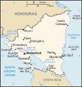
Nicaragua is the largest country in the Central American American isthmus, bordered by Honduras to the north and Costa Rica to the south. The country is situated between 11 and 14 degrees north of the Equator in the Northern Hemisphere, which places it entirely within the tropics. The Pacific Ocean...
is a country in Central America
Central America
Central America is the central geographic region of the Americas. It is the southernmost, isthmian portion of the North American continent, which connects with South America on the southeast. When considered part of the unified continental model, it is considered a subcontinent...
, bordering both the Caribbean Sea
Caribbean Sea
The Caribbean Sea is a sea of the Atlantic Ocean located in the tropics of the Western hemisphere. It is bounded by Mexico and Central America to the west and southwest, to the north by the Greater Antilles, and to the east by the Lesser Antilles....
and the North Pacific Ocean
Pacific Ocean
The Pacific Ocean is the largest of the Earth's oceanic divisions. It extends from the Arctic in the north to the Southern Ocean in the south, bounded by Asia and Australia in the west, and the Americas in the east.At 165.2 million square kilometres in area, this largest division of the World...
, between Costa Rica
Costa Rica
Costa Rica , officially the Republic of Costa Rica is a multilingual, multiethnic and multicultural country in Central America, bordered by Nicaragua to the north, Panama to the southeast, the Pacific Ocean to the west and the Caribbean Sea to the east....
and Honduras
Honduras
Honduras is a republic in Central America. It was previously known as Spanish Honduras to differentiate it from British Honduras, which became the modern-day state of Belize...
. Approximately the size of Greece or the U.S. state of New York, it is the largest country in Central America. The country covers a total area of 129,494 square kilometers (120,254 square kilometers of which are land area) and contains a diversity of climates and terrains. The country's physical geography divides it into three major zones: Pacific lowlands, the wetter, cooler central highlands, and the Caribbean lowlands.
Geographic coordinates:
13°00′N 85°00′W
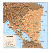
Pacific lowlands
The Pacific lowlands extend about 75 kilometers inland from the Pacific coast. Most of the area is flat, except for a line of young volcanoVolcano
2. Bedrock3. Conduit 4. Base5. Sill6. Dike7. Layers of ash emitted by the volcano8. Flank| 9. Layers of lava emitted by the volcano10. Throat11. Parasitic cone12. Lava flow13. Vent14. Crater15...
es, many of which are still active, running between the Golfo de Fonseca and Lago de Nicaragua. These peaks lie just west of a large crustal fracture or structural rift that forms a long, narrow depression passing southeast across the isthmus from the Golfo de Fonseca to the Río San Juan
San Juan River (Nicaragua)
The San Juan River , also known as El Desaguadero , is a 192.06 km river that flows east out of Lake Nicaragua into the Caribbean Sea. A large section of the border between Nicaragua and Costa Rica runs on the right bank of the river...
. The rift is occupied in part by the largest freshwater lakes in Central America: Lago de Managua
Lake Managua
Lake Managua is a lake in Nicaragua. The Spanish name is Lago de Managua or Lago Xolotlán. At 1,042 km², it is approximately long and wide. Similarly to the name of Lake Nicaragua, its name was coined by the Spanish conquerors from "Mangue" and agua...
(56 kilometers long and 24 kilometers wide) and Lago de Nicaragua (about 160 kilometers long and 75 kilometers wide). These two lakes are joined by the Río Tipitapa, which flows south into Lago de Nicaragua. Lago de Nicaragua in turn drains into the Río San Juan (the boundary between Nicaragua
Nicaragua
Nicaragua is the largest country in the Central American American isthmus, bordered by Honduras to the north and Costa Rica to the south. The country is situated between 11 and 14 degrees north of the Equator in the Northern Hemisphere, which places it entirely within the tropics. The Pacific Ocean...
and Costa Rica
Costa Rica
Costa Rica , officially the Republic of Costa Rica is a multilingual, multiethnic and multicultural country in Central America, bordered by Nicaragua to the north, Panama to the southeast, the Pacific Ocean to the west and the Caribbean Sea to the east....
), which flows through the southern part of the rift lowlands to the Caribbean Sea. The valley of the Río San Juan forms a natural passageway close to sea level across the Nicaraguan isthmus from the Caribbean Sea to Lago de Nicaragua and the rift. From the southwest edge of Lago de Nicaragua, it is only nineteen kilometers to the Pacific Ocean. This route was considered as a possible alternative to the Panama Canal
Panama Canal
The Panama Canal is a ship canal in Panama that joins the Atlantic Ocean and the Pacific Ocean and is a key conduit for international maritime trade. Built from 1904 to 1914, the canal has seen annual traffic rise from about 1,000 ships early on to 14,702 vessels measuring a total of 309.6...
at various times in the past.
Surrounding the lakes and extending northwest of them along the rift valley to the Golfo de Fonseca are fertile lowland plains highly enriched with volcanic ash
Volcanic ash
Volcanic ash consists of small tephra, which are bits of pulverized rock and glass created by volcanic eruptions, less than in diameter. There are three mechanisms of volcanic ash formation: gas release under decompression causing magmatic eruptions; thermal contraction from chilling on contact...
from nearby volcanoes. These lowlands are densely populated and well cultivated. More directly west of the lake region is a narrow line of ash-covered hills and volcanoes that separate the lakes from the Pacific Ocean. This line is highest in the central portion near León and Managua
Managua
Managua is the capital city of Nicaragua as well as the department and municipality by the same name. It is the largest city in Nicaragua in terms of population and geographic size. Located on the southwestern shore of Lake Xolotlán or Lake Managua, the city was declared the national capital in...
.
Because Western Nicaragua is located where two major tectonic plates collide, it is subject to earthquake
Earthquake
An earthquake is the result of a sudden release of energy in the Earth's crust that creates seismic waves. The seismicity, seismism or seismic activity of an area refers to the frequency, type and size of earthquakes experienced over a period of time...
s and volcanic eruptions. Although periodic volcanic eruptions have caused agricultural damage from fumes and ash, earthquakes have been by far more destructive to life and property. Hundreds of shocks occur each year, some of which cause severe damage. The capital city of Managua
Managua
Managua is the capital city of Nicaragua as well as the department and municipality by the same name. It is the largest city in Nicaragua in terms of population and geographic size. Located on the southwestern shore of Lake Xolotlán or Lake Managua, the city was declared the national capital in...
was virtually destroyed in 1931 and again in 1972.
Central highlands
The triangular area known as the central highlands lies northeast and east of the Pacific lowlands. This rugged mountains is composed of ridges 900 to 1,800 meters high and a mixed forest of oak and pine alternating with deep valleys that drain primarily toward the CaribbeanCaribbean
The Caribbean is a crescent-shaped group of islands more than 2,000 miles long separating the Gulf of Mexico and the Caribbean Sea, to the west and south, from the Atlantic Ocean, to the east and north...
. Very few significant streams flow west to the Pacific Ocean; those that do are steep, short, and flow intermittently. The relatively dry western slopes of the central highlands, protected by the ridges of the highlands from the moist winds of the Caribbean, have drawn farmers from the Pacific region since colonial times and are now well settled. The eastern slopes
Caribbean lowland
The eastern Caribbean lowlands of Nicaragua form the extensive (occupying more than 50 percent of national territory) and still sparsely settled lowland area known as the Costa de Mosquitos (Miskito Coast). The Caribbean lowlands are sometimes considered synonymous with the former department of ZelayaZelaya (Nicaragua)
Zelaya is a former department in Nicaragua. The capital was Bluefields. In 1986 it was divided into two autonomous regions:* Región Autónoma del Atlántico Norte * Región Autónoma del Atlántico Sur...
, which is now divided into the North Atlantic Autonomous Region (Región Autonomista Atlántico Norte, RAAN) and the South Atlantic Autonomous Region (Región Autonomista Atlántico Sur, RAAS) and constitutes about 45 percent of Nicaragua's territory. These lowlands are a hot, humid area that includes coastal plains, the eastern spurs of the central highlands, and the lower portion of the Río San Juan
San Juan River (Nicaragua)
The San Juan River , also known as El Desaguadero , is a 192.06 km river that flows east out of Lake Nicaragua into the Caribbean Sea. A large section of the border between Nicaragua and Costa Rica runs on the right bank of the river...
basin. The soil is generally leached and infertile. Pine and palm savanna
Savanna
A savanna, or savannah, is a grassland ecosystem characterized by the trees being sufficiently small or widely spaced so that the canopy does not close. The open canopy allows sufficient light to reach the ground to support an unbroken herbaceous layer consisting primarily of C4 grasses.Some...
s predominate as far south as the Laguna de Perlas
Laguna de Perlas
Pearl Lagoon is a town in the municipality by the same name. It is located in Región Autónoma del Atlántico Sur department of Nicaragua...
. Tropical rain forests are characteristic from the Laguna de Perlas to the Río San Juan, in the interior west of the savannas, and along rivers through the savannas. Fertile soils are found only along the natural levees and narrow floodplains of the numerous rivers, including the Escondido, the Río Grande de Matagalpa, the Prinzapolka
Prinzapolka
Prinzapolka is a municipality in the Región Autónoma del Atlántico Norte department of Nicaragua.Prinzapolka is also an important river basin in the Atlantic Region of Nicaragua 330km .- External links :...
, and the Coco, and along the many lesser streams that rise in the central highlands and cross the region en route to the complex of shallow bay
Bay
A bay is an area of water mostly surrounded by land. Bays generally have calmer waters than the surrounding sea, due to the surrounding land blocking some waves and often reducing winds. Bays also exist as an inlet in a lake or pond. A large bay may be called a gulf, a sea, a sound, or a bight...
s, lagoon
Lagoon
A lagoon is a body of shallow sea water or brackish water separated from the sea by some form of barrier. The EU's habitat directive defines lagoons as "expanses of shallow coastal salt water, of varying salinity or water volume, wholly or partially separated from the sea by sand banks or shingle,...
s, and salt marsh
Salt marsh
A salt marsh is an environment in the upper coastal intertidal zone between land and salt water or brackish water, it is dominated by dense stands of halophytic plants such as herbs, grasses, or low shrubs. These plants are terrestrial in origin and are essential to the stability of the salt marsh...
es of the Caribbean coast.
Climates
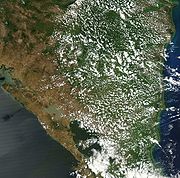
Temperature varies little with the seasons in Nicaragua and is largely a function of elevation.The"hot land," is characteristic of the foothills and lowlands from sea level to about 750 metres (2,461 ft) of elevation.And night temperatures drop to 21 to 24 °C (69.8 to 75.2 °F) most of the year. The tierra templada, or the "temperate land," is characteristic of most of the central highlands, where elevations range between 750 and 1600 m (2,460.6 and 5,249.3 ft).The "cold land," at elevations above 1600 metres (5,249 ft), is found only on and near the highest peaks of the central highlands. Daytime averages in this region are 22 to 24 °C (71.6 to 75.2 °F), with nighttime lows below 15 °C (59 °F).Rainfall varies greatly in Nicaragua. The Caribbean lowlands are the wettest section of Central America, receiving between 2500 and 6500 mm (98.4 and 255.9 in) of rain annually. The western slopes of the central highlands and the Pacific lowlands receive considerably less annual rainfall, being protected from moisture-laden Caribbean trade winds by the peaks of the central highlands. Mean annual precipitation for the rift valley and western slopes of the highlands ranges from 1000 to 1500 mm (39.4 to 59.1 in). Rainfall is seasonal—May through October is the rainy season, and December through April is the driest period.
During the rainy season, Eastern Nicaragua is subject to heavy flooding along the upper and middle reaches of all major rivers. Near the coast, where river courses widen and river banks and natural levees are low, floodwaters spill over onto the floodplains until large sections of the lowlands become continuous sheets of water. River bank agricultural plots are often heavily damaged, and considerable numbers of savanna animals die during these floods. The coast is also subject to destructive tropical storms and hurricanes, particularly from July through October. The high winds and floods accompanying these storms often cause considerable destruction of property. In addition, heavy rains (called papagayo storms) accompanying the passage of a cold front or a low-pressure area may sweep from the north through both eastern and western Nicaragua (particularly the rift valley) from November through March. Hurricanes or heavy rains in the central highlands, where agriculture has destroyed much of the natural vegetation, also cause considerable crop damage and soil erosion. In 1988 Hurricane Joan forced hundreds of thousands of Nicaraguans to flee their homes and caused more than US$1 billion in damage, most of it along the Caribbean coast.
Antipodes
Although nowhere in Central America is antipodalAntipodes
In geography, the antipodes of any place on Earth is the point on the Earth's surface which is diametrically opposite to it. Two points that are antipodal to one another are connected by a straight line running through the centre of the Earth....
to another land mass, Nicaragua comes closest, with its Big Corn Island within half a kilometer of being antipodal to the South Island of the Australian Cocos (Keeling) Islands
Cocos (Keeling) Islands
The Territory of the Cocos Islands, also called Cocos Islands and Keeling Islands, is a territory of Australia, located in the Indian Ocean, southwest of Christmas Island and approximately midway between Australia and Sri Lanka....
in the Indian Ocean.
Statistics
Area:total:
129,494 km2
land:
120,254 km2
water:
9,240 km2
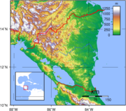
Elevation extremes:
lowest point:
Pacific Ocean 0 m
highest point:
Mogotón
Mogoton
Mogotón is a mountain in the Reserva Nacional Cordillera Dipilto y Jalapa on the border of Nicaragua and Honduras. It rises above sea level and is the highest point in Nicaragua.-External links:* * http://www.cerromogotonnicaragua.dorosevich.com/gpage.html...
2,107 m
Land use:
arable land:
9%
permanent crops:
1%
permanent pastures:
46%
forests and woodland:
27%
other:
17% (1993 est.)
Irrigated land:
880 km2 (1993 est.)
Environment
Nicaragua is subject to destructive earthquakeEarthquake
An earthquake is the result of a sudden release of energy in the Earth's crust that creates seismic waves. The seismicity, seismism or seismic activity of an area refers to the frequency, type and size of earthquakes experienced over a period of time...
s, volcano
Volcano
2. Bedrock3. Conduit 4. Base5. Sill6. Dike7. Layers of ash emitted by the volcano8. Flank| 9. Layers of lava emitted by the volcano10. Throat11. Parasitic cone12. Lava flow13. Vent14. Crater15...
es, landslide
Landslide
A landslide or landslip is a geological phenomenon which includes a wide range of ground movement, such as rockfalls, deep failure of slopes and shallow debris flows, which can occur in offshore, coastal and onshore environments...
s, and occasionally severe hurricanes. It currently faces deforestation
Deforestation
Deforestation is the removal of a forest or stand of trees where the land is thereafter converted to a nonforest use. Examples of deforestation include conversion of forestland to farms, ranches, or urban use....
, soil erosion, and water pollution. It is a party to the United Nations Framework Convention on Climate Change
United Nations Framework Convention on Climate Change
The United Nations Framework Convention on Climate Change is an international environmental treaty produced at the United Nations Conference on Environment and Development , informally known as the Earth Summit, held in Rio de Janeiro from June 3 to 14, 1992...
, the Climate Change-Kyoto Protocol, the Nuclear Test Ban, and the Ozone Layer Protection, and has signed but not ratified the Law of the Sea
Law of the sea
Law of the sea may refer to:* United Nations Convention on the Law of the Sea* Admiralty law* The Custom of the Sea...
.