

Geography of Kazakhstan
Encyclopedia
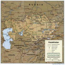
Kazakhstan
is located in Central Asia
and Eastern Europe
. With an area of about 2,717,300 square kilometers, Kazakhstan is more than twice the combined size of the other four Central Asian states, or about twice the size of Alaska
. The country borders Turkmenistan
, Uzbekistan
, and Kyrgyzstan
to the south; Russia
to the north; Russia and the Caspian Sea
to the west; and China's Xinjiang Uygur Autonomous Region
to the east.
Geographic coordinates:
 There is considerable topographical variation within Kazakhstan. The highest point is the top of the mountain Khan Tengri
, on the Kyrgyz border in the Tian Shan
range, with an elevation of + 7,010 meters; the lowest point is the bottom of the Karagiye
depression at -132 m, in the Mangystau province east of the Caspian Sea
. Most of the country lies at between 200 and 300 meters above sea level, but Kazakhstan's Caspian shore includes some of the lowest elevations on Earth.
Many of the peaks of the Altay
and Tian Shan ranges are snow covered year-round, and their run-off is the source for most of Kazakhstan's rivers and streams.
Except for the Tobol
, Ishim
, and Irtysh rivers (the Kazak names for which are, respectively, Tobyl, Esil, and Ertis), portions of which flow through Kazakhstan, all of Kazakhstan's rivers and streams are part of landlocked systems. They either flow into isolated bodies of water such as the Caspian Sea or simply disappear into the steppes and deserts of central and southern Kazakhstan. Many rivers, streams, and lakes are seasonal, evaporating in summer. The three largest bodies of water are Lake Balkhash
, a partially fresh, partially saline lake in the east, near Almaty
, and the Caspian and Aral Sea
s, both of which lie partially within Kazakhstan.
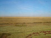
Some 9.4 % of Kazakhstan's land is mixed prairie and forest or treeless prairie, primarily in the north or in the basin of the Ural River
in the west. More than three-quarters of the country, including the entire west and most of the south, is either semidesert (33.2 %) or desert (44 %). The terrain in these regions is bare, eroded, broken uplands, with sand dunes in the Qizilqum
('The Red Sands'; in the Russian form, Kyzylkum) and Moyunqum (in the Russian form, Muyunkum (Муюнкум)) deserts, which occupy south-central Kazakhstan.
 The environment of Kazakhstan has been badly damaged by human activity. Most of the water in Kazakhstan is polluted by industrial effluents, pesticide and fertilizer residue, and, in some places, radioactivity. The most visible damage has been to the Aral Sea, which as recently as the 1970s was larger than any of the Great Lakes
of North America
save Lake Superior
. The sea began to shrink rapidly when sharply increased irrigation and other demands on the only significant tributaries, the Syr Darya
and the Amu Darya
(the latter reaching the Aral from neighboring Uzbekistan), all but eliminated inflow. By 1993 the Aral Sea had lost an estimated 60 % of its volume, in the process breaking into three unconnected segments. Increasing salinity and reduced habitat have killed the Aral Sea's fish, hence destroying its once-active fishing industry, and the receding shoreline has left the former port of Aral'sk more than seventy kilometers from the water's edge. The depletion of this large body of water has increased temperature variations in the region, which in turn have had an impact on agriculture. A much greater agricultural impact, however, has come from the salt- and pesticide-laden soil that the wind is known to carry as far away as the Himalaya Mountains and the Pacific Ocean
. Deposition of this heavily saline soil on nearby fields effectively sterilizes them. Evidence suggests that salts, pesticides, and residues of chemical fertilizers are also adversely affecting human life around the former Aral Sea; infant mortality in the region approaches 10 % compared with the 1991 national rate of 2.7 %.
By contrast, the water level of the Caspian Sea has been rising steadily since 1978 for reasons that scientists have not been able to explain fully. At the northern end of the sea, more than 10,000 square kilometres of land in Atyrau Province
have been flooded. Experts estimate that if current rates of increase persist, the coastal city of Atyrau, eighty-eight other population centers, and many of Kazakhstan's Caspian oil fields could be submerged by 2020.
Wind erosion has also had an impact in the northern and central parts of the republic because of the introduction of wide-scale dryland wheat farming. In the 1950s and 1960s, much soil was lost when vast tracts of Kazakhstan's prairies were plowed under as part of Khrushchev's Virgin Lands agricultural project. By the mid-1990s, an estimated 60 % of the republic's pastureland was in various stages of desertification.
Industrial pollution is a bigger concern in Kazakhstan's manufacturing cities, where aging factories pump huge quantities of unfiltered pollutants into the air and groundwater. The former capital, Almaty, is particularly threatened, in part because of the postindependence boom in private automobile ownership.
The gravest environmental threat to Kazakhstan comes from radiation, especially in the Semey
(Semipalatinsk) region of the northeast, where the Soviet Union
tested almost 500 nuclear weapons, 116 of them above ground. Often, such tests were conducted without evacuating or even alerting the local population. Although nuclear testing was halted in 1990, radiation poisoning, birth defects, severe anemia, and leukemia
are very common in the area.
With some conspicuous exceptions, lip service has been the primary official response to Kazakhstan's ecological problems. In February 1989, opposition to Soviet nuclear testing and its ill effects in Kazakhstan led to the creation of one of the republic's largest and most influential grass-roots movements, Nevada-Semipalatinsk, which was founded by Kazak poet and public figure Olzhas Suleymenov. In the first week of the movement's existence, Nevada-Semipalatinsk gathered more than 2 million signatures from Kazakhstanis of all ethnic groups on a petition to Mikhail Gorbachev
demanding the end of nuclear testing in Kazakhstan. After a year of demonstrations and protests, the test ban took effect in 1990. It remained in force in 1996, although in 1995 at least one unexploded device reportedly was still in position near Semey.
Once its major ecological objective was achieved, Nevada-Semipalatinsk made various attempts to broaden into a more general political movement; it has not pursued a broad ecological or "green" agenda. A very small green party, Tabigat, made common cause with the political opposition in the parliament of 1994.
The government has established a Ministry of Ecology and Bioresources, with a separate administration for radioecology
, but the ministry's programs are underfunded and given low priority. In 1994 only 23 % of budgeted funds were actually allotted to environmental programs. Many official meetings and conferences are held (more than 300 have been devoted to the problem of the Aral Sea alone), but few practical programs have gone into operation. In 1994 the World Bank
, the International Monetary Fund
(IMF), and the United States Environmental Protection Agency
agreed to give Kazakhstan US$62 million to help the country overcome ecological problems.
Natural hazards:
Environment—current issues:
Environment—international agreements:
Land boundaries:
Coastline:
Maritime claims:
Elevation extremes:
Kazakhstan
Kazakhstan , officially the Republic of Kazakhstan, is a transcontinental country in Central Asia and Eastern Europe. Ranked as the ninth largest country in the world, it is also the world's largest landlocked country; its territory of is greater than Western Europe...
is located in Central Asia
Central Asia
Central Asia is a core region of the Asian continent from the Caspian Sea in the west, China in the east, Afghanistan in the south, and Russia in the north...
and Eastern Europe
Eastern Europe
Eastern Europe is the eastern part of Europe. The term has widely disparate geopolitical, geographical, cultural and socioeconomic readings, which makes it highly context-dependent and even volatile, and there are "almost as many definitions of Eastern Europe as there are scholars of the region"...
. With an area of about 2,717,300 square kilometers, Kazakhstan is more than twice the combined size of the other four Central Asian states, or about twice the size of Alaska
Alaska
Alaska is the largest state in the United States by area. It is situated in the northwest extremity of the North American continent, with Canada to the east, the Arctic Ocean to the north, and the Pacific Ocean to the west and south, with Russia further west across the Bering Strait...
. The country borders Turkmenistan
Turkmenistan
Turkmenistan , formerly also known as Turkmenia is one of the Turkic states in Central Asia. Until 1991, it was a constituent republic of the Soviet Union, the Turkmen Soviet Socialist Republic . Turkmenistan is one of the six independent Turkic states...
, Uzbekistan
Uzbekistan
Uzbekistan , officially the Republic of Uzbekistan is a doubly landlocked country in Central Asia and one of the six independent Turkic states. It shares borders with Kazakhstan to the west and to the north, Kyrgyzstan and Tajikistan to the east, and Afghanistan and Turkmenistan to the south....
, and Kyrgyzstan
Kyrgyzstan
Kyrgyzstan , officially the Kyrgyz Republic is one of the world's six independent Turkic states . Located in Central Asia, landlocked and mountainous, Kyrgyzstan is bordered by Kazakhstan to the north, Uzbekistan to the west, Tajikistan to the southwest and China to the east...
to the south; Russia
Russia
Russia or , officially known as both Russia and the Russian Federation , is a country in northern Eurasia. It is a federal semi-presidential republic, comprising 83 federal subjects...
to the north; Russia and the Caspian Sea
Caspian Sea
The Caspian Sea is the largest enclosed body of water on Earth by area, variously classed as the world's largest lake or a full-fledged sea. The sea has a surface area of and a volume of...
to the west; and China's Xinjiang Uygur Autonomous Region
Xinjiang
Xinjiang is an autonomous region of the People's Republic of China. It is the largest Chinese administrative division and spans over 1.6 million km2...
to the east.
Geographic coordinates:
- 48°00′N 68°00′E
Topography and drainage
Khan Tengri
Khan Tengri is a mountain of the Tian Shan mountain range. It is located on the China—Kyrgyzstan—Kazakhstan border, east of lake Issyk Kul. Its geologic elevation is , but its glacial cap rises to...
, on the Kyrgyz border in the Tian Shan
Tian Shan
The Tian Shan , also spelled Tien Shan, is a large mountain system located in Central Asia. The highest peak in the Tian Shan is Victory Peak , ....
range, with an elevation of + 7,010 meters; the lowest point is the bottom of the Karagiye
Karagiye
Karagiye is a long karst trench close to the Caspian Sea. At approximately below sea level it is the lowest point both in Kazakhstan and the former USSR...
depression at -132 m, in the Mangystau province east of the Caspian Sea
Caspian Sea
The Caspian Sea is the largest enclosed body of water on Earth by area, variously classed as the world's largest lake or a full-fledged sea. The sea has a surface area of and a volume of...
. Most of the country lies at between 200 and 300 meters above sea level, but Kazakhstan's Caspian shore includes some of the lowest elevations on Earth.
Many of the peaks of the Altay
Altay Mountains
The Altai Mountains are a mountain range in East-Central Asia, where Russia, China, Mongolia and Kazakhstan come together, and where the rivers Irtysh and Ob have their sources. The Altai Mountains are known as the original locus of the speakers of Turkic as well as other members of the proposed...
and Tian Shan ranges are snow covered year-round, and their run-off is the source for most of Kazakhstan's rivers and streams.
Except for the Tobol
Tobol River
Tobol is a river in Kurgan and Tyumen Oblasts in Russia and Kazakhstan, left tributary of the Irtysh. The length of the Tobol River is 1591 km. The area of its drainage basin is 426,000 km². Average discharge at mouth is 805 m³/s. The lower reaches of the river freeze up in late October -...
, Ishim
Ishim River
Ishim River is a river running through Kazakhstan and Russia. Its length is 2,450 km , average discharge is 56,3 m³/s . It is a left tributary of the Irtysh River. The Ishim River is partly navigable in its lower reaches. The upper course of the Ishim passes through Astana, the capital of Kazakhstan...
, and Irtysh rivers (the Kazak names for which are, respectively, Tobyl, Esil, and Ertis), portions of which flow through Kazakhstan, all of Kazakhstan's rivers and streams are part of landlocked systems. They either flow into isolated bodies of water such as the Caspian Sea or simply disappear into the steppes and deserts of central and southern Kazakhstan. Many rivers, streams, and lakes are seasonal, evaporating in summer. The three largest bodies of water are Lake Balkhash
Lake Balkhash
Lake Balkhash is one of the largest lakes in Asia and 12th largest continental lake in the world. It is located in southeastern Kazakhstan, in Central Asia, and belongs to an endorheic basin shared by Kazakhstan and China, with a small part in Kyrgyzstan. The basin drains into the lake via seven...
, a partially fresh, partially saline lake in the east, near Almaty
Almaty
Almaty , also known by its former names Verny and Alma-Ata , is the former capital of Kazakhstan and the nation's largest city, with a population of 1,348,500...
, and the Caspian and Aral Sea
Aral Sea
The Aral Sea was a lake that lay between Kazakhstan in the north and Karakalpakstan, an autonomous region of Uzbekistan, in the south...
s, both of which lie partially within Kazakhstan.
Some 9.4 % of Kazakhstan's land is mixed prairie and forest or treeless prairie, primarily in the north or in the basin of the Ural River
Ural River
The Ural or Jayıq/Zhayyq , known as Yaik before 1775, is a river flowing through Russia and Kazakhstan. It arises in the southern Ural Mountains and ends at the Caspian Sea. Its total length is 1,511 mi making it the third longest river in Europe after the Volga and the Danube...
in the west. More than three-quarters of the country, including the entire west and most of the south, is either semidesert (33.2 %) or desert (44 %). The terrain in these regions is bare, eroded, broken uplands, with sand dunes in the Qizilqum
Kyzyl Kum
The Kyzyl Kum , also called Qyzylqum, is the 11th largest desert in the world. Its name means Red Sand in Turkic languages. It is located in Central Asia in the doab between the rivers Amu Darya and Syr Darya, and is divided between Kazakhstan, Uzbekistan and Turkmenistan...
('The Red Sands'; in the Russian form, Kyzylkum) and Moyunqum (in the Russian form, Muyunkum (Муюнкум)) deserts, which occupy south-central Kazakhstan.
Climate
The Climate in Kazakhstan is continental. In summer the temperatures average more than 30 °C (86 °F) and in winter average -12 °C.Environmental problems
Great Lakes
The Great Lakes are a collection of freshwater lakes located in northeastern North America, on the Canada – United States border. Consisting of Lakes Superior, Michigan, Huron, Erie, and Ontario, they form the largest group of freshwater lakes on Earth by total surface, coming in second by volume...
of North America
North America
North America is a continent wholly within the Northern Hemisphere and almost wholly within the Western Hemisphere. It is also considered a northern subcontinent of the Americas...
save Lake Superior
Lake Superior
Lake Superior is the largest of the five traditionally-demarcated Great Lakes of North America. It is bounded to the north by the Canadian province of Ontario and the U.S. state of Minnesota, and to the south by the U.S. states of Wisconsin and Michigan. It is the largest freshwater lake in the...
. The sea began to shrink rapidly when sharply increased irrigation and other demands on the only significant tributaries, the Syr Darya
Syr Darya
The Syr Darya , also transliterated Syrdarya or Sirdaryo, is a river in Central Asia, sometimes known as the Jaxartes or Yaxartes from its Ancient Greek name . The Greek name is derived from Old Persian, Yakhsha Arta , a reference to the color of the river's water...
and the Amu Darya
Amu Darya
The Amu Darya , also called Oxus and Amu River, is a major river in Central Asia. It is formed by the junction of the Vakhsh and Panj rivers...
(the latter reaching the Aral from neighboring Uzbekistan), all but eliminated inflow. By 1993 the Aral Sea had lost an estimated 60 % of its volume, in the process breaking into three unconnected segments. Increasing salinity and reduced habitat have killed the Aral Sea's fish, hence destroying its once-active fishing industry, and the receding shoreline has left the former port of Aral'sk more than seventy kilometers from the water's edge. The depletion of this large body of water has increased temperature variations in the region, which in turn have had an impact on agriculture. A much greater agricultural impact, however, has come from the salt- and pesticide-laden soil that the wind is known to carry as far away as the Himalaya Mountains and the Pacific Ocean
Pacific Ocean
The Pacific Ocean is the largest of the Earth's oceanic divisions. It extends from the Arctic in the north to the Southern Ocean in the south, bounded by Asia and Australia in the west, and the Americas in the east.At 165.2 million square kilometres in area, this largest division of the World...
. Deposition of this heavily saline soil on nearby fields effectively sterilizes them. Evidence suggests that salts, pesticides, and residues of chemical fertilizers are also adversely affecting human life around the former Aral Sea; infant mortality in the region approaches 10 % compared with the 1991 national rate of 2.7 %.
By contrast, the water level of the Caspian Sea has been rising steadily since 1978 for reasons that scientists have not been able to explain fully. At the northern end of the sea, more than 10,000 square kilometres of land in Atyrau Province
Atyrau Province
Atyrau Oblast is a province of Kazakhstan. It is situated in the west of the country around the northeast of the Caspian Sea. Its capital is the city of Atyrau, with a population of 142,500 people; the province itself has 480,000 people...
have been flooded. Experts estimate that if current rates of increase persist, the coastal city of Atyrau, eighty-eight other population centers, and many of Kazakhstan's Caspian oil fields could be submerged by 2020.
Wind erosion has also had an impact in the northern and central parts of the republic because of the introduction of wide-scale dryland wheat farming. In the 1950s and 1960s, much soil was lost when vast tracts of Kazakhstan's prairies were plowed under as part of Khrushchev's Virgin Lands agricultural project. By the mid-1990s, an estimated 60 % of the republic's pastureland was in various stages of desertification.
Industrial pollution is a bigger concern in Kazakhstan's manufacturing cities, where aging factories pump huge quantities of unfiltered pollutants into the air and groundwater. The former capital, Almaty, is particularly threatened, in part because of the postindependence boom in private automobile ownership.
The gravest environmental threat to Kazakhstan comes from radiation, especially in the Semey
Semey
Semey , formerly known as Semipalatinsk and Alash-kala , is a city in Kazakhstan, in the northeastern province of East Kazakhstan, near the border with Siberia, around north of Almaty, and southeast of the Russian city of Omsk, along the Irtysh River.-History:The first settlement was in 1718,...
(Semipalatinsk) region of the northeast, where the Soviet Union
Soviet Union
The Soviet Union , officially the Union of Soviet Socialist Republics , was a constitutionally socialist state that existed in Eurasia between 1922 and 1991....
tested almost 500 nuclear weapons, 116 of them above ground. Often, such tests were conducted without evacuating or even alerting the local population. Although nuclear testing was halted in 1990, radiation poisoning, birth defects, severe anemia, and leukemia
Leukemia
Leukemia or leukaemia is a type of cancer of the blood or bone marrow characterized by an abnormal increase of immature white blood cells called "blasts". Leukemia is a broad term covering a spectrum of diseases...
are very common in the area.
With some conspicuous exceptions, lip service has been the primary official response to Kazakhstan's ecological problems. In February 1989, opposition to Soviet nuclear testing and its ill effects in Kazakhstan led to the creation of one of the republic's largest and most influential grass-roots movements, Nevada-Semipalatinsk, which was founded by Kazak poet and public figure Olzhas Suleymenov. In the first week of the movement's existence, Nevada-Semipalatinsk gathered more than 2 million signatures from Kazakhstanis of all ethnic groups on a petition to Mikhail Gorbachev
Mikhail Gorbachev
Mikhail Sergeyevich Gorbachev is a former Soviet statesman, having served as General Secretary of the Communist Party of the Soviet Union from 1985 until 1991, and as the last head of state of the USSR, having served from 1988 until its dissolution in 1991...
demanding the end of nuclear testing in Kazakhstan. After a year of demonstrations and protests, the test ban took effect in 1990. It remained in force in 1996, although in 1995 at least one unexploded device reportedly was still in position near Semey.
Once its major ecological objective was achieved, Nevada-Semipalatinsk made various attempts to broaden into a more general political movement; it has not pursued a broad ecological or "green" agenda. A very small green party, Tabigat, made common cause with the political opposition in the parliament of 1994.
The government has established a Ministry of Ecology and Bioresources, with a separate administration for radioecology
Radioecology
Radioecology is a branch of ecology, which studies how radioactive substances interact with nature; how different mechanisms affect the substances’ migration and uptake in food chain and ecosystems...
, but the ministry's programs are underfunded and given low priority. In 1994 only 23 % of budgeted funds were actually allotted to environmental programs. Many official meetings and conferences are held (more than 300 have been devoted to the problem of the Aral Sea alone), but few practical programs have gone into operation. In 1994 the World Bank
World Bank
The World Bank is an international financial institution that provides loans to developing countries for capital programmes.The World Bank's official goal is the reduction of poverty...
, the International Monetary Fund
International Monetary Fund
The International Monetary Fund is an organization of 187 countries, working to foster global monetary cooperation, secure financial stability, facilitate international trade, promote high employment and sustainable economic growth, and reduce poverty around the world...
(IMF), and the United States Environmental Protection Agency
United States Environmental Protection Agency
The U.S. Environmental Protection Agency is an agency of the federal government of the United States charged with protecting human health and the environment, by writing and enforcing regulations based on laws passed by Congress...
agreed to give Kazakhstan US$62 million to help the country overcome ecological problems.
Natural hazards:
- EarthquakeEarthquakeAn earthquake is the result of a sudden release of energy in the Earth's crust that creates seismic waves. The seismicity, seismism or seismic activity of an area refers to the frequency, type and size of earthquakes experienced over a period of time...
s in the south, mud slides around AlmatyAlmatyAlmaty , also known by its former names Verny and Alma-Ata , is the former capital of Kazakhstan and the nation's largest city, with a population of 1,348,500...
Environment—current issues:
- Radioactive or toxic chemical sites associated with its former defense industries and test ranges are found throughout the country and pose health risks for humans and animals; industrial pollution is severe in some cities; because the two main rivers which flowed into the Aral Sea have been diverted for irrigation, it is drying up and leaving behind a harmful layer of chemical pesticides and natural salts; these substances are then picked up by the wind and blown into noxious dust storms; pollution in the Caspian Sea; soil pollution from overuse of agricultural chemicals and salination from poor infrastructure and wasteful irrigation practices
Environment—international agreements:
- Party to: BiodiversityBiodiversityBiodiversity is the degree of variation of life forms within a given ecosystem, biome, or an entire planet. Biodiversity is a measure of the health of ecosystems. Biodiversity is in part a function of climate. In terrestrial habitats, tropical regions are typically rich whereas polar regions...
, Climate ChangeUnited Nations Framework Convention on Climate ChangeThe United Nations Framework Convention on Climate Change is an international environmental treaty produced at the United Nations Conference on Environment and Development , informally known as the Earth Summit, held in Rio de Janeiro from June 3 to 14, 1992...
, DesertificationDesertificationDesertification is the degradation of land in drylands. Caused by a variety of factors, such as climate change and human activities, desertification is one of the most significant global environmental problems.-Definitions:...
, Endangered SpeciesEndangered speciesAn endangered species is a population of organisms which is at risk of becoming extinct because it is either few in numbers, or threatened by changing environmental or predation parameters...
, Ozone Layer Protection, Ship Pollution (MARPOL 73/78MARPOL 73/78Marpol 73/78 is the International Convention for the Prevention of Pollution From Ships, 1973 as modified by the Protocol of 1978....
) - Signed, but not ratified: Climate Change-Kyoto ProtocolKyoto ProtocolThe Kyoto Protocol is a protocol to the United Nations Framework Convention on Climate Change , aimed at fighting global warming...
Area and boundaries
Area:- Total: 2,717,300 km²
- Land: 2,669,800 km²
- Water: 47,500 km²
Land boundaries:
- Total: 12,012 km
- Border countries: the People's Republic of ChinaPeople's Republic of ChinaChina , officially the People's Republic of China , is the most populous country in the world, with over 1.3 billion citizens. Located in East Asia, the country covers approximately 9.6 million square kilometres...
1,533 km, KyrgyzstanKyrgyzstanKyrgyzstan , officially the Kyrgyz Republic is one of the world's six independent Turkic states . Located in Central Asia, landlocked and mountainous, Kyrgyzstan is bordered by Kazakhstan to the north, Uzbekistan to the west, Tajikistan to the southwest and China to the east...
1,051 km, RussiaRussiaRussia or , officially known as both Russia and the Russian Federation , is a country in northern Eurasia. It is a federal semi-presidential republic, comprising 83 federal subjects...
6,846 km, TurkmenistanTurkmenistanTurkmenistan , formerly also known as Turkmenia is one of the Turkic states in Central Asia. Until 1991, it was a constituent republic of the Soviet Union, the Turkmen Soviet Socialist Republic . Turkmenistan is one of the six independent Turkic states...
379 km, UzbekistanUzbekistanUzbekistan , officially the Republic of Uzbekistan is a doubly landlocked country in Central Asia and one of the six independent Turkic states. It shares borders with Kazakhstan to the west and to the north, Kyrgyzstan and Tajikistan to the east, and Afghanistan and Turkmenistan to the south....
2,203 km
Coastline:
- 0 km (landlocked). Kazakhstan borders the Aral SeaAral SeaThe Aral Sea was a lake that lay between Kazakhstan in the north and Karakalpakstan, an autonomous region of Uzbekistan, in the south...
, now split into two bodies of water (1,070 km), and the Caspian SeaCaspian SeaThe Caspian Sea is the largest enclosed body of water on Earth by area, variously classed as the world's largest lake or a full-fledged sea. The sea has a surface area of and a volume of...
(1,894 km).
Maritime claims:
- None (landlocked)
Elevation extremes:
- Lowest point: KaragiyeKaragiyeKaragiye is a long karst trench close to the Caspian Sea. At approximately below sea level it is the lowest point both in Kazakhstan and the former USSR...
-132 m - Highest point: Khan Tangiri Shyngy (Pik Khan-Tengri) 7,010 m