

Geography of Jordan
Encyclopedia
Jordan
Jordan , officially the Hashemite Kingdom of Jordan , Al-Mamlaka al-Urduniyya al-Hashemiyya) is a kingdom on the East Bank of the River Jordan. The country borders Saudi Arabia to the east and south-east, Iraq to the north-east, Syria to the north and the West Bank and Israel to the west, sharing...
is situated geographically in Southwest Asia
Southwest Asia
Western Asia, West Asia, Southwest Asia or Southwestern Asia are terms that describe the westernmost portion of Asia. The terms are partly coterminous with the Middle East, which describes a geographical position in relation to Western Europe rather than its location within Asia...
, south of Syria
Syria
Syria , officially the Syrian Arab Republic , is a country in Western Asia, bordering Lebanon and the Mediterranean Sea to the West, Turkey to the north, Iraq to the east, Jordan to the south, and Israel to the southwest....
, west of Iraq
Iraq
Iraq ; officially the Republic of Iraq is a country in Western Asia spanning most of the northwestern end of the Zagros mountain range, the eastern part of the Syrian Desert and the northern part of the Arabian Desert....
northwest of Saudi Arabia
Saudi Arabia
The Kingdom of Saudi Arabia , commonly known in British English as Saudi Arabia and in Arabic as as-Sa‘ūdiyyah , is the largest state in Western Asia by land area, constituting the bulk of the Arabian Peninsula, and the second-largest in the Arab World...
and east of Israel
Israel
The State of Israel is a parliamentary republic located in the Middle East, along the eastern shore of the Mediterranean Sea...
and the West Bank
West Bank
The West Bank ) of the Jordan River is the landlocked geographical eastern part of the Palestinian territories located in Western Asia. To the west, north, and south, the West Bank shares borders with the state of Israel. To the east, across the Jordan River, lies the Hashemite Kingdom of Jordan...
; politically, the area has also been referred to in the West
Western world
The Western world, also known as the West and the Occident , is a term referring to the countries of Western Europe , the countries of the Americas, as well all countries of Northern and Central Europe, Australia and New Zealand...
as the Middle
Middle East
The Middle East is a region that encompasses Western Asia and Northern Africa. It is often used as a synonym for Near East, in opposition to Far East...
or Near East
Near East
The Near East is a geographical term that covers different countries for geographers, archeologists, and historians, on the one hand, and for political scientists, economists, and journalists, on the other...
. The territory of Jordan now covers about 91,880 square kilometers. Between 1950 and the Six Day War in 1967, although not widely recognized, Jordan claimed and administered an additional 5,880 square kilometers encompassing the West Bank; in 1988 and with continuing Israeli occupation, King Hussein relinquished Jordan's claim to the West Bank
West Bank
The West Bank ) of the Jordan River is the landlocked geographical eastern part of the Palestinian territories located in Western Asia. To the west, north, and south, the West Bank shares borders with the state of Israel. To the east, across the Jordan River, lies the Hashemite Kingdom of Jordan...
in favor of the Palestinians.
Jordan is landlocked except at its southern extremity, where nearly twenty-six kilometers of shoreline along the Gulf of Aqaba
Gulf of Aqaba
The Gulf of Aqaba is a large gulf located at the northern tip of the Red Sea. In pre twentieth-century and modern sources it is often named the Gulf of Eilat, as Eilat is its predominant Israeli city ....
provide access to the Red Sea
Red Sea
The Red Sea is a seawater inlet of the Indian Ocean, lying between Africa and Asia. The connection to the ocean is in the south through the Bab el Mandeb strait and the Gulf of Aden. In the north, there is the Sinai Peninsula, the Gulf of Aqaba, and the Gulf of Suez...
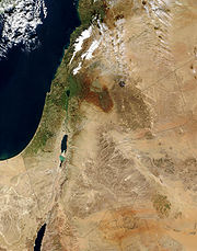
. A great north-south geological rift, forming the depression of Lake Tiberias (Sea of Galilee), the Jordan Valley
Jordan Valley (Middle East)
The Jordan Valley forms part of the larger Jordan Rift Valley. It is 120 kilometers long and 15 kilometers wide, where it runs from Lake Tiberias in the north to northern Dead Sea in the south. It runs for an additional 155 kilometer south of the Dead Sea to Aqaba, an area also known as Wadi...
, and the Dead Sea
Dead Sea
The Dead Sea , also called the Salt Sea, is a salt lake bordering Jordan to the east and Israel and the West Bank to the west. Its surface and shores are below sea level, the lowest elevation on the Earth's surface. The Dead Sea is deep, the deepest hypersaline lake in the world...
, is the dominant topographical feature.
Geographic coordinates:
31°00′N 36°00′E
Boundaries
Except for small sections of the borders with Israel and SyriaSyria
Syria , officially the Syrian Arab Republic , is a country in Western Asia, bordering Lebanon and the Mediterranean Sea to the West, Turkey to the north, Iraq to the east, Jordan to the south, and Israel to the southwest....
, Jordan's international boundaries
Border
Borders define geographic boundaries of political entities or legal jurisdictions, such as governments, sovereign states, federated states and other subnational entities. Some borders—such as a state's internal administrative borders, or inter-state borders within the Schengen Area—are open and...
do not follow well-defined natural features of the terrain. The country's boundaries were established by various international agreements, and, with the exception of the border with Israel
Israel
The State of Israel is a parliamentary republic located in the Middle East, along the eastern shore of the Mediterranean Sea...
, none was in dispute in early 1989.
Jordan's boundaries with Syria
Syria
Syria , officially the Syrian Arab Republic , is a country in Western Asia, bordering Lebanon and the Mediterranean Sea to the West, Turkey to the north, Iraq to the east, Jordan to the south, and Israel to the southwest....
, Iraq
Iraq
Iraq ; officially the Republic of Iraq is a country in Western Asia spanning most of the northwestern end of the Zagros mountain range, the eastern part of the Syrian Desert and the northern part of the Arabian Desert....
, and Saudi Arabia
Saudi Arabia
The Kingdom of Saudi Arabia , commonly known in British English as Saudi Arabia and in Arabic as as-Sa‘ūdiyyah , is the largest state in Western Asia by land area, constituting the bulk of the Arabian Peninsula, and the second-largest in the Arab World...
do not have the special significance that the border with Israel does; these borders have not always hampered tribal nomads in their movements, yet for a few groups borders did separate them from traditional grazing areas and delimited by a series of agreements between the United Kingdom and the government of what eventually became Saudi Arabia) was first formally defined in the Hadda Agreement of 1925. In 1965 Jordan and Saudi Arabia concluded a bilateral agreement that realigned and delimited the boundary. The realignment resulted in some exchange of territory, and Jordan's coastline on the Gulf of Aqaba was lengthened by about eighteen kilometers. The new boundary enabled Jordan to expand its port facilities and established a zone in which the two parties agreed to share petroleum revenues equally if oil were discovered. The agreement also protected the pasturage and watering rights of nomadic tribes inside the exchanged territories.
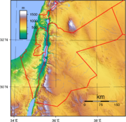
Topography
By far the greatest part of the East Bank is desert
Desert
A desert is a landscape or region that receives an extremely low amount of precipitation, less than enough to support growth of most plants. Most deserts have an average annual precipitation of less than...
, displaying the land forms and other features associated with great aridity. Most of this land is part of the great Syrian (or North Arabian) Desert (see fig. 4). There are broad expanses of sand and dunes, particularly in the south and southeast, together with salt flats. Occasional jumbles of sandstone hills or low mountains support only meager and stunted vegetation that thrives for a short period after the scanty winter rains. These areas support little life and are the least populated regions of Jordan.
The drainage network is coarse and incised. In many areas the relief provides no eventual outlet to the sea, so that sedimentary deposits accumulate in basins where moisture evaporates or is absorbed in the ground. Toward the depression in the western part of the East Bank, the desert rises gradually into the Jordanian Highlands—a steppe country of high, deeply cut limestone plateaus with an average elevation of about 900 meters. Occasional summits in this region reach 1,200 meters in the northern part and exceed 1,700 meters in the southern part; the highest peak is Jabal Ramm at 1,754 meters (though the highest peak in all of Jordan is Jabal Umm al Dami at 1854 meters. It is located in a remote part of southern Jordan). These highlands are an area of long-settled villages. Until about the 1940s, persons living in these villages depended upon rain-fed agriculture for their livelihood.
The western edge of this plateau country forms an escarpment along the eastern side of the Jordan River-Dead Sea depression and its continuation south of the Dead Sea. Most of the wadis that provide drainage from the plateau country into the depression carry water only during the short season of winter rains. Sharply incised with deep, canyonlike walls, whether wet or dry the wadis can be formidable obstacles to travel.
The Jordan River is short, but from its mountain headwaters (approximately 160 kilometers north of the river's mouth at the Dead Sea) the riverbed drops from an elevation of about 3,000 meters above sea level to more than 400 meters below sea level. Before reaching Jordanian territory the river forms the Sea of Galilee
Sea of Galilee
The Sea of Galilee, also Kinneret, Lake of Gennesaret, or Lake Tiberias , is the largest freshwater lake in Israel, and it is approximately in circumference, about long, and wide. The lake has a total area of , and a maximum depth of approximately 43 m...
, the surface of which is 212 meters below sea level. The Jordan River's principal tributary is the Yarmouk River. Near the junction of the two rivers, the Yarmouk forms the boundary between Israel on the northwest, Syria on the northeast, and Jordan on the south. The Az Zarqa River
Zarqa River
The Zarqa River is the second largest tributary of the lower Jordan River, after the Yarmouk River. It is the third largest river in the region by annual discharge, and its watershed encompasses the most densely populated areas east of the Jordan River...
, the second main tributary of the Jordan River, rises and empties entirely within the East Bank.
A 380-kilometer-long rift valley runs from the Yarmouk River in the north to Al Aqaba in the south. The northern part, from the Yarmouk River to the Dead Sea, is commonly known as the Jordan Valley. It is divided into eastern and western parts by the Jordan River. Bordered by a steep escarpment on both the eastern and the western side, the valley reaches a maximum width of twenty-two kilometers at some points. The valley is properly known as the Al Ghawr (the depression, or valley, also seen as Al Ghor).
The rift valley on the southern side of the Dead Sea is known as the Southern Ghawr and the Wadi al Jayb (popularly known as the Wadi al Arabah). The Southern Ghawr runs from Wadi al Hammah, on the south side of the Dead Sea, to Ghawr Faya, about twenty-five kilometers south of the Dead Sea. Wadi al Jayb is 180 kilometers long, from the southern shore of the Dead Sea to Al Aqaba in the south. The valley floor varies in level. In the south, it reaches its lowest level at the Dead Sea (more than 400 meters below sea level), rising in the north to just above sea level. Evaporation from the sea is extreme due to year-round high temperatures. The water contains about 250 grams of dissolved salts per liter at the surface and reaches the saturation point at 110 meters.
The Dead Sea occupies the deepest depression on the land surface of the earth. The depth of the depression is accentuated by the surrounding mountains and highlands that rise to elevations of 800 to 1,200 meters above sea level. The sea's greatest depth is about 430 meters, and it thus reaches a point more than 825 meters below sea level. A drop in the level of the sea has caused the former Lisan Peninsula to become a land bridge dividing the sea into separate northern and southern basins.
Climate
The major characteristic of the climate is the contrast between a relatively rainy season from November to April and very dry weather for the rest of the year. With hot, dry, uniform summers and cool, variable winters during which practically all of the precipitationPrecipitation (meteorology)
In meteorology, precipitation In meteorology, precipitation In meteorology, precipitation (also known as one of the classes of hydrometeors, which are atmospheric water phenomena is any product of the condensation of atmospheric water vapor that falls under gravity. The main forms of precipitation...
occurs, the country has a Mediterranean-style climate
Mediterranean climate
A Mediterranean climate is the climate typical of most of the lands in the Mediterranean Basin, and is a particular variety of subtropical climate...
. In general, the farther inland from the Mediterranean Sea
Mediterranean Sea
The Mediterranean Sea is a sea connected to the Atlantic Ocean surrounded by the Mediterranean region and almost completely enclosed by land: on the north by Anatolia and Europe, on the south by North Africa, and on the east by the Levant...
a given part of the country lies, the greater are the seasonal contrasts in temperature and the less rainfall. Atmospheric pressure
Atmospheric pressure
Atmospheric pressure is the force per unit area exerted into a surface by the weight of air above that surface in the atmosphere of Earth . In most circumstances atmospheric pressure is closely approximated by the hydrostatic pressure caused by the weight of air above the measurement point...
s during the summer months are relatively uniform, whereas the winter months bring a succession of marked low pressure areas and accompanying cold front
Cold front
A cold front is defined as the leading edge of a cooler mass of air, replacing a warmer mass of air.-Development of cold front:The cooler and denser air wedges under the less-dense warmer air, lifting it...
s. These cyclonic disturbances generally move eastward from over the Mediterranean Sea several times a month and result in sporadic precipitation.
Most of the East Bank receives less than 120 millimetres (4.7 in) of rain a year and may be classified as a dry desert
Desert
A desert is a landscape or region that receives an extremely low amount of precipitation, less than enough to support growth of most plants. Most deserts have an average annual precipitation of less than...
or steppe
Steppe
In physical geography, steppe is an ecoregion, in the montane grasslands and shrublands and temperate grasslands, savannas, and shrublands biomes, characterized by grassland plains without trees apart from those near rivers and lakes...
region. Where the ground rises to form the highlands east of the Jordan Valley, precipitation increases to around 300 millimetres (11.8 in) in the south and 500 millimetres (19.7 in) or more in the north. The Jordan Valley
Jordan Rift Valley
The Jordan Rift Valley is an elongated depression located in modern-day Israel, Jordan and the Palestinian territories. This geographic region includes the Jordan River, Jordan Valley, Hula Valley, Lake Tiberias and the Dead Sea, the lowest land elevation on Earth...
, lying in the lee of high ground on the West Bank, forms a narrow climatic zone that annually receives up to 300 millimetres (11.8 in) of rain in the northern reaches; rain dwindles to less than 120 millimetres (4.7 in) at the head of the Dead Sea
Dead Sea
The Dead Sea , also called the Salt Sea, is a salt lake bordering Jordan to the east and Israel and the West Bank to the west. Its surface and shores are below sea level, the lowest elevation on the Earth's surface. The Dead Sea is deep, the deepest hypersaline lake in the world...
.
The country's long summer reaches a peak during August. January is usually the coolest month. The fairly wide ranges of temperature during a twenty-four-hour period are greatest during the summer months and have a tendency to increase with higher elevation and distance from the Mediterranean seacoast. Daytime temperatures during the summer months frequently exceed 36 °C (96.8 °F) and average about 32 °C (89.6 °F). In contrast, the winter months—November to April—bring moderately cool and sometimes cold weather, averaging about 13 °C (55.4 °F). Except in the rift depression, frost is fairly common during the winter, it may take the form of snow at the higher elevations of the north western highlands. Usually it snow
Snow
Snow is a form of precipitation within the Earth's atmosphere in the form of crystalline water ice, consisting of a multitude of snowflakes that fall from clouds. Since snow is composed of small ice particles, it is a granular material. It has an open and therefore soft structure, unless packed by...
s a couple of times a year in western Amman
Amman
Amman is the capital of Jordan. It is the country's political, cultural and commercial centre and one of the oldest continuously inhabited cities in the world. The Greater Amman area has a population of 2,842,629 as of 2010. The population of Amman is expected to jump from 2.8 million to almost...
.
For a month or so before and after the summer dry season, hot, dry air from the desert, drawn by low pressure, produces strong winds from the south or southeast that sometimes reach gale
Gale
A gale is a very strong wind. There are conflicting definitions of how strong a wind must be to be considered a gale. The U.S. government's National Weather Service defines a gale as 34–47 knots of sustained surface winds. Forecasters typically issue gale warnings when winds of this strength are...
force. Known in the Middle East by various names, including the khamsin, this dry, sirocco-style wind is usually accompanied by great dust clouds. Its onset is heralded by a hazy sky, a falling barometer
Barometer
A barometer is a scientific instrument used in meteorology to measure atmospheric pressure. Pressure tendency can forecast short term changes in the weather...
, and a drop in relative humidity to about 10 percent. Within a few hours there may be a 10 F-change to 15 F-change rise in temperature. These windstorms ordinarily last a day or so, cause much discomfort, and destroy crop
Crop
Crop may refer to:* Crop, a plant grown and harvested for agricultural use* Crop , part of the alimentary tract of some animals* Crop , a modified whip used in horseback riding or disciplining humans...
s by desiccating them.
The shamal
Shamal (wind)
A shamal is a northwesterly wind blowing over Iraq and the Persian Gulf states , often strong during the day, but decreasing at night. This weather effect occurs anywhere from once to several times a year, mostly in summer but sometimes in winter...
, another wind of some significance, comes from the north or northwest, generally at intervals between June and September. Remarkably steady during daytime hours but becoming a breeze at night, the shammal may blow for as long as nine days out of ten and then repeat the process. It originates as a dry continental mass of polar air that is warmed as it passes over the Eurasia
Eurasia
Eurasia is a continent or supercontinent comprising the traditional continents of Europe and Asia ; covering about 52,990,000 km2 or about 10.6% of the Earth's surface located primarily in the eastern and northern hemispheres...
n landmass. The dryness allows intense heating of the Earth's surface by the sun, resulting in high daytime temperatures that moderate after sunset.
Area and boundaries
Area:total: 89,213 km²
land: 88,884 km²
water: 329 km²
Land boundaries:
total: 1,619 km
border countries:
Iraq
Iraq
Iraq ; officially the Republic of Iraq is a country in Western Asia spanning most of the northwestern end of the Zagros mountain range, the eastern part of the Syrian Desert and the northern part of the Arabian Desert....
181 km, Israel
Israel
The State of Israel is a parliamentary republic located in the Middle East, along the eastern shore of the Mediterranean Sea...
238 km, Saudi Arabia
Saudi Arabia
The Kingdom of Saudi Arabia , commonly known in British English as Saudi Arabia and in Arabic as as-Sa‘ūdiyyah , is the largest state in Western Asia by land area, constituting the bulk of the Arabian Peninsula, and the second-largest in the Arab World...
728 km, Syria
Syria
Syria , officially the Syrian Arab Republic , is a country in Western Asia, bordering Lebanon and the Mediterranean Sea to the West, Turkey to the north, Iraq to the east, Jordan to the south, and Israel to the southwest....
375 km, West Bank
West Bank
The West Bank ) of the Jordan River is the landlocked geographical eastern part of the Palestinian territories located in Western Asia. To the west, north, and south, the West Bank shares borders with the state of Israel. To the east, across the Jordan River, lies the Hashemite Kingdom of Jordan...
97 km
Coastline: 26 km
Maritime claims:
territorial sea:
3 nmi (5.556 km)
Elevation extremes:
lowest point: Dead Sea
Dead Sea
The Dead Sea , also called the Salt Sea, is a salt lake bordering Jordan to the east and Israel and the West Bank to the west. Its surface and shores are below sea level, the lowest elevation on the Earth's surface. The Dead Sea is deep, the deepest hypersaline lake in the world...
-408 m
highest point: Jabal Umm al Damn 1,854 m
Resources and land use
Natural resources: phosphatePhosphate
A phosphate, an inorganic chemical, is a salt of phosphoric acid. In organic chemistry, a phosphate, or organophosphate, is an ester of phosphoric acid. Organic phosphates are important in biochemistry and biogeochemistry or ecology. Inorganic phosphates are mined to obtain phosphorus for use in...
s, potash
Potash
Potash is the common name for various mined and manufactured salts that contain potassium in water-soluble form. In some rare cases, potash can be formed with traces of organic materials such as plant remains, and this was the major historical source for it before the industrial era...
, oil shale
Oil shale
Oil shale, an organic-rich fine-grained sedimentary rock, contains significant amounts of kerogen from which liquid hydrocarbons called shale oil can be produced...
Land use:
arable land
Arable land
In geography and agriculture, arable land is land that can be used for growing crops. It includes all land under temporary crops , temporary meadows for mowing or pasture, land under market and kitchen gardens and land temporarily fallow...
:
4%
permanent crops:
1%
permanent pastures:
9%
forest
Forest
A forest, also referred to as a wood or the woods, is an area with a high density of trees. As with cities, depending where you are in the world, what is considered a forest may vary significantly in size and have various classification according to how and what of the forest is composed...
s and woodland
Woodland
Ecologically, a woodland is a low-density forest forming open habitats with plenty of sunlight and limited shade. Woodlands may support an understory of shrubs and herbaceous plants including grasses. Woodland may form a transition to shrubland under drier conditions or during early stages of...
:
1%
other:
85% (1993 est.)
Irrigated land:
630 km² (1993 est.)
Environmental concerns
Natural hazards:Occasional minor earthquakes in areas close to the Jordan Rift Valley
Environment - current issues:
limited natural fresh water resources and water stress
Water stress
Researchers define water stress and water scarcity in different ways. For example, some have presented maps showing the physical existence of water in nature to show nations with lower or higher volumes of water available for use. Others have related water availability to population...
; deforestation
Deforestation
Deforestation is the removal of a forest or stand of trees where the land is thereafter converted to a nonforest use. Examples of deforestation include conversion of forestland to farms, ranches, or urban use....
; overgrazing
Overgrazing
Overgrazing occurs when plants are exposed to intensive grazing for extended periods of time, or without sufficient recovery periods. It can be caused by either livestock in poorly managed agricultural applications, or by overpopulations of native or non-native wild animals.Overgrazing reduces the...
; soil erosion; desertification
Desertification
Desertification is the degradation of land in drylands. Caused by a variety of factors, such as climate change and human activities, desertification is one of the most significant global environmental problems.-Definitions:...
Environment - international agreements:
party to:
Biodiversity
Biodiversity
Biodiversity is the degree of variation of life forms within a given ecosystem, biome, or an entire planet. Biodiversity is a measure of the health of ecosystems. Biodiversity is in part a function of climate. In terrestrial habitats, tropical regions are typically rich whereas polar regions...
, Climate Change
United Nations Framework Convention on Climate Change
The United Nations Framework Convention on Climate Change is an international environmental treaty produced at the United Nations Conference on Environment and Development , informally known as the Earth Summit, held in Rio de Janeiro from June 3 to 14, 1992...
, Desertification
Desertification
Desertification is the degradation of land in drylands. Caused by a variety of factors, such as climate change and human activities, desertification is one of the most significant global environmental problems.-Definitions:...
, Endangered Species
Endangered species
An endangered species is a population of organisms which is at risk of becoming extinct because it is either few in numbers, or threatened by changing environmental or predation parameters...
, Hazardous Wastes, Law of the Sea
Law of the sea
Law of the sea may refer to:* United Nations Convention on the Law of the Sea* Admiralty law* The Custom of the Sea...
, Marine Dumping, Nuclear Test Ban, Ozone Layer Protection, Wetlands
signed, but not ratified:
none of the selected agreements
See also
- Winston's HiccupWinston's HiccupWinston's Hiccup or Churchill's Sneeze is the huge zigzag in Jordan's eastern border with Saudi Arabia, supposedly because Winston Churchill drew the boundary of Transjordan after a generous and lengthy lunch.-In modern times:...