

Geography of Colorado
Encyclopedia
Colorado
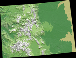
Colorado is a U.S. state that encompasses much of the Rocky Mountains as well as the northeastern portion of the Colorado Plateau and the western edge of the Great Plains...
is diverse, encompassing both rugged mountainous terrain, vast plains, desert lands, desert canyons, and mesas. The state of Colorado is defined as the geospherical rectangle that stretches from 37°N
37th parallel north
The 37th parallel north is a circle of latitude that is 37 degrees north of the Earth's equatorial plane. It crosses Europe, the Mediterranean Sea, Africa, Asia, the Pacific Ocean, North America, and the Atlantic Ocean....
to 41°N
41st parallel north
The 41st parallel north is a circle of latitude that is 41 degrees north of the Earth's equatorial plane. It crosses Europe, the Mediterranean Sea, Asia, the Pacific Ocean, North America, and the Atlantic Ocean....
latitude and from 102°03'W
25th meridian west from Washington
The 25th meridian of longitude west from Washington is a line of longitude approximately 102.05 degrees west of the Prime Meridian of Greenwich...
to 109°03'W
32nd meridian west from Washington
The 32nd meridian of longitude west from Washington is a line of longitude approximately 109°02′48″ west of the Prime Meridian of Greenwich. In the United States of America, the meridian 32 degrees west of the Washington Meridian defines the western boundaries of the State of Colorado and the...
longitude (25°W
25th meridian west from Washington
The 25th meridian of longitude west from Washington is a line of longitude approximately 102.05 degrees west of the Prime Meridian of Greenwich...
to 32°W
32nd meridian west from Washington
The 32nd meridian of longitude west from Washington is a line of longitude approximately 109°02′48″ west of the Prime Meridian of Greenwich. In the United States of America, the meridian 32 degrees west of the Washington Meridian defines the western boundaries of the State of Colorado and the...
from the Washington Meridian
Washington meridian
The Washington meridian was one of four prime meridians of the United States which passed through Washington, D.C.. The four which have been specified are:# through the Capitol# through the White House# through the old Naval Observatory...
). Colorado is one of only three U.S. state
U.S. state
A U.S. state is any one of the 50 federated states of the United States of America that share sovereignty with the federal government. Because of this shared sovereignty, an American is a citizen both of the federal entity and of his or her state of domicile. Four states use the official title of...
s (with Wyoming
Wyoming
Wyoming is a state in the mountain region of the Western United States. The western two thirds of the state is covered mostly with the mountain ranges and rangelands in the foothills of the Eastern Rocky Mountains, while the eastern third of the state is high elevation prairie known as the High...
and Utah
Utah
Utah is a state in the Western United States. It was the 45th state to join the Union, on January 4, 1896. Approximately 80% of Utah's 2,763,885 people live along the Wasatch Front, centering on Salt Lake City. This leaves vast expanses of the state nearly uninhabited, making the population the...
) that have only lines of latitude
Latitude
In geography, the latitude of a location on the Earth is the angular distance of that location south or north of the Equator. The latitude is an angle, and is usually measured in degrees . The equator has a latitude of 0°, the North pole has a latitude of 90° north , and the South pole has a...
and longitude
Longitude
Longitude is a geographic coordinate that specifies the east-west position of a point on the Earth's surface. It is an angular measurement, usually expressed in degrees, minutes and seconds, and denoted by the Greek letter lambda ....
for boundaries.
The summit of Mount Elbert
Mount Elbert
Mount Elbert is the highest peak in the Rocky Mountains of North America, at , the highest of the fourteeners in Colorado, and the high point of the Sawatch Range. It is located in Lake County, approximately southwest of Leadville...
at 4401 meters (14,440 ft) elevation in Lake County
Lake County, Colorado
Lake County is one of the 64 counties of the State of Colorado of the United States. The highest natural point in Colorado and the entire Rocky Mountains is the summit of Mount Elbert in Lake County at 14,440 feet elevation. The county population was 7,812 at U.S. Census 2000. The county seat...
is the state's highest point and the highest point in the entire Rocky Mountains
Rocky Mountains
The Rocky Mountains are a major mountain range in western North America. The Rocky Mountains stretch more than from the northernmost part of British Columbia, in western Canada, to New Mexico, in the southwestern United States...
. Colorado has approximately 550 mountain peaks that exceed 4000 meters (13,123 ft) elevation. Colorado is the only U.S. state that lies entirely above 1000 meters (3281 ft) elevation. The state's lowest elevation is 1010 meters (3315 ft) at the point on the eastern boundary of Yuma County
Yuma County, Colorado
Yuma County is the 14th most extensive of the 64 counties of the State of Colorado of the United States. The county population was 9,841 at U.S. Census 2000...
where the Arikaree River
Arikaree River
The Arikaree River is a tributary of the Republican River that starts near Limon in Lincoln County, Colorado. The river flows east into Kansas, crossing the extreme northwestern corner of that state before entering Nebraska...
flows into the state of Kansas
Kansas
Kansas is a US state located in the Midwestern United States. It is named after the Kansas River which flows through it, which in turn was named after the Kansa Native American tribe, which inhabited the area. The tribe's name is often said to mean "people of the wind" or "people of the south...
.
Regions
To the east of the Rocky MountainsRocky Mountains
The Rocky Mountains are a major mountain range in western North America. The Rocky Mountains stretch more than from the northernmost part of British Columbia, in western Canada, to New Mexico, in the southwestern United States...
in Colorado are the Colorado Eastern Plains
Colorado Eastern Plains
The Eastern Plains of Colorado refers to a region of the U.S. state of Colorado east of the Rocky Mountains and east of the population centers of the Front Range.-Geography:...
/High Plains
High Plains (United States)
The High Plains are a subregion of the Great Plains mostly in the Western United States, but also partly in the Midwest states of Nebraska, Kansas, and South Dakota, generally encompassing the western part of the Great Plains before the region reaches the Rocky Mountains...
, the section of the Great Plains
Great Plains
The Great Plains are a broad expanse of flat land, much of it covered in prairie, steppe and grassland, which lies west of the Mississippi River and east of the Rocky Mountains in the United States and Canada. This area covers parts of the U.S...
within Colorado at elevations ranging from 3,500 to 7,000 feet (1,000 to 2,000 m). The Midwest
Midwestern United States
The Midwestern United States is one of the four U.S. geographic regions defined by the United States Census Bureau, providing an official definition of the American Midwest....
states of Kansas
Kansas
Kansas is a US state located in the Midwestern United States. It is named after the Kansas River which flows through it, which in turn was named after the Kansa Native American tribe, which inhabited the area. The tribe's name is often said to mean "people of the wind" or "people of the south...
and Nebraska
Nebraska
Nebraska is a state on the Great Plains of the Midwestern United States. The state's capital is Lincoln and its largest city is Omaha, on the Missouri River....
border Colorado to the east and northeast.
The plains are sparsely settled with most population along the South Platte
South Platte River
The South Platte River is one of the two principal tributaries of the Platte River and itself a major river of the American Midwest and the American Southwest/Mountain West, located in the U.S. states of Colorado and Nebraska...
and the Arkansas
Arkansas River
The Arkansas River is a major tributary of the Mississippi River. The Arkansas generally flows to the east and southeast as it traverses the U.S. states of Colorado, Kansas, Oklahoma, and Arkansas. The river's initial basin starts in the Western United States in Colorado, specifically the Arkansas...
rivers. Rainfall is meager, averaging about 15 inches (380 mm) annually. There is some irrigated farming, but much of the land is used for dryland farming
Dryland farming
Dryland farming is an agricultural technique for non-irrigated cultivation of drylands.-Locations:Dryland farming is used in the Great Plains, the Palouse plateau of Eastern Washington, and other arid regions of North America, the Middle East and in other grain growing regions such as the steppes...
or ranching. Winter wheat
Winter wheat
Winter wheat is a type of wheat that is planted from September to December in the Northern Hemisphere. Winter wheat sprouts before freezing occurs, then becomes dormant until the soil warms in the spring. Winter wheat needs a few weeks of cold before being able to flower, however persistent snow...
is a typical crop and most small towns in the region boast both a water tower
Water tower
A water tower or elevated water tower is a large elevated drinking water storage container constructed to hold a water supply at a height sufficient to pressurize a water distribution system....
and a grain elevator
Grain elevator
A grain elevator is a tower containing a bucket elevator, which scoops up, elevates, and then uses gravity to deposit grain in a silo or other storage facility...
.
The bulk of Colorado's population lives along the eastern edge of the Rocky Mountains in the Front Range Urban Corridor
Front Range Urban Corridor
The Front Range Urban Corridor is an oblong region of urban population located along the eastern face of the Southern Rocky Mountains in the U.S. states of Colorado and Wyoming. The corridor derives its name from the Front Range, the mountain range that defines the west central boundary of the...
. This region is partially protected from prevailing storms by the high mountains to the west.
Rocky Mountains
The Rocky Mountains are a major mountain range in western North America. The Rocky Mountains stretch more than from the northernmost part of British Columbia, in western Canada, to New Mexico, in the southwestern United States...
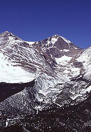
with notable peaks such as Longs Peak
Longs Peak
Longs Peak is one of the 53 mountains with summits over 14,000 feet in Colorado. It can be prominently seen from Longmont, Colorado, as well as from the rest of the Colorado Front Range. It is named after Major Stephen Long, who explored the area in the 1820s...
, Mount Evans
Mount Evans
Mount Evans is a mountain in the Front Range region of the Rocky Mountains, in Clear Creek County, Colorado. It is one of 54 fourteeners in Colorado, and the closest fourteener to Denver...
, Pikes Peak
Pikes Peak
Pikes Peak is a mountain in the Front Range of the Rocky Mountains, west of Colorado Springs, Colorado, in El Paso County in the United States of America....
, and the Spanish Peaks
Spanish Peaks
The Spanish Peaks are a pair of volcanic mountains located in southwestern Huerfano County, Colorado. The Ute indians named them Huajatolla , meaning "two breasts". The Spanish name translates as "Breasts of the Earth". The two peaks, West Spanish Peak and East Spanish Peak, are the easternmost...
near Walsenburg
Walsenburg, Colorado
The City of Walsenburg or Los Leones is a Statutory City that is the county seat and the most populous city of Huerfano County, Colorado, United States...
in the south. This area drains to the east, is forested, and partially urbanized. With urbanization, utilization of the forest for timbering and grazing resulted in accumulation of fuel. During the drought of 2002 devastating forest fires swept this area.
The Continental Divide
Continental Divide
The Continental Divide of the Americas, or merely the Continental Gulf of Division or Great Divide, is the name given to the principal, and largely mountainous, hydrological divide of the Americas that separates the watersheds that drain into the Pacific Ocean from those river systems that drain...
stretches along the crest of the Rocky Mountains. To the west of the Continental Divide is the Western Slope. Water west of the Continental Divide drains west into the Pacific Ocean
Pacific Ocean
The Pacific Ocean is the largest of the Earth's oceanic divisions. It extends from the Arctic in the north to the Southern Ocean in the south, bounded by Asia and Australia in the west, and the Americas in the east.At 165.2 million square kilometres in area, this largest division of the World...
via the Colorado River. Western Colorado is made up of mountains, mesas, desert canyons, and desert lands.
Within the interior of the Rocky Mountains are several large parks or high broad basins. In the north, on the east side of the Continental Divide is North Park
North Park (Colorado basin)
North Park is a high, sparsely populated basin in the Rocky Mountains in north central Colorado in the United States. It encompasses a wide valley in Jackson County rimmed by mountain ranges at the headwaters of the North Platte River and several smaller tributaries, including the Michigan River,...
. North Park is drained by the North Platte River
North Platte River
The North Platte River is a major tributary of the Platte River and is approximately long counting its many curves, It travels about distance. Its course lies in the U.S...
, which flows north into the northwest
Northwestern United States
The Northwestern United States comprise the northwestern states up to the western Great Plains regions of the United States, and consistently include the states of Oregon, Washington, Idaho, Montana, Wyoming, to which part of southeast Alaska is also sometimes included...
state of Wyoming
Wyoming
Wyoming is a state in the mountain region of the Western United States. The western two thirds of the state is covered mostly with the mountain ranges and rangelands in the foothills of the Eastern Rocky Mountains, while the eastern third of the state is high elevation prairie known as the High...
. Just south but on the west side of the Continental Divide is Middle Park
Middle Park (Colorado basin)
Middle Park is a high basin in the Rocky Mountains of north-central Colorado in the United States. It is located in Grand County, on the southwest slope of Rocky Mountain National Park, approximately 50 miles west of Boulder.-Description:The basin surrounds the headwaters of the Colorado River...
, drained by the Colorado River. South Park
South Park (Colorado basin)
South Park is a high intermontane grassland basin, approximately 10,000 ft in elevation, in the Rocky Mountains of central Colorado. It encompasses approximately 1,000 square miles around the headwaters of the South Platte River in Park County approximately 60 mi southwest of Denver...
is the headwaters of the South Platte River. To the south lies the San Luis Valley
San Luis Valley
The San Luis Valley is an extensive alpine valley in the U.S. states of Colorado and New Mexico covering approximately and sitting at an average elevation of above sea level. The valley sits atop the Rio Grande Rift and is drained to the south by the Rio Grande River, which rises in the San Juan...
, the headwaters of the Rio Grande
Rio Grande
The Rio Grande is a river that flows from southwestern Colorado in the United States to the Gulf of Mexico. Along the way it forms part of the Mexico – United States border. Its length varies as its course changes...
, which drains into New Mexico
New Mexico
New Mexico is a state located in the southwest and western regions of the United States. New Mexico is also usually considered one of the Mountain States. With a population density of 16 per square mile, New Mexico is the sixth-most sparsely inhabited U.S...
. Across the Sangre de Cristo Range
Sangre de Cristo Range
The Sangre de Cristo Range, called the East Range locally in the San Luis Valley, is a narrow mountain range of the Rocky Mountains running north and south along the east side of the Rio Grande Rift in southern Colorado in the United States...
to the east of the San Luis Valley lies the Wet Mountain Valley
Wet Mountain Valley
The Wet Mountain Valley is a high elevation mountain valley located in Custer County in south-central Colorado. The towns in the valley are Westcliffe and Silver Cliff, which are at an elevation of just under 8,000 feet...
. These basins, particularly the San Luis Valley, lie along the Rio Grande Rift
Rio Grande Rift
The Rio Grande Rift is a north-trending continental rift zone. It separates the Colorado Plateau in the west from the interior of the North American craton on the east. The rift extends from central Colorado in the north to the state of Chihuahua, Mexico in the south. The rift zone consists of four...
, a major tectonic feature. See Rift
Rift
In geology, a rift or chasm is a place where the Earth's crust and lithosphere are being pulled apart and is an example of extensional tectonics....
.
The Rocky Mountains within Colorado contain 54 peaks that are 14,000 feet (4270 m) or higher, known as fourteener
Fourteener
In mountaineering terminology in the United States, a fourteener is a mountain that exceeds 14,000 feet above mean sea level. There are 547 fourteeners in the world. The importance of fourteeners is greatest in Colorado, which has the majority of such peaks in North America...
s. The mountains are timbered with conifers and aspen
Aspen
Populus section Populus, of the Populus genus, includes the aspen trees and the white poplar Populus alba. The five typical aspens are all native to cold regions with cool summers, in the north of the Northern Hemisphere, extending south at high altitudes in the mountains. The White Poplar, by...
to the tree line, at an elevation of about 12,000 feet (3,650 m) in southern Colorado to about 10,500 feet (3,200 m) in northern Colorado; above this only alpine vegetation grows. The Rockies are snow-covered only in the winter; most snow melts by mid-August with the exception of a few small glaciers. The Colorado Mineral Belt
Colorado Mineral Belt
The Colorado Mineral Belt is an area with abundant ore deposits. The area stretches north-east from the La Plata Mountains in Southwestern Colorado to the Front Range near Boulder, Colorado...
, stretching from the San Juan Mountains
San Juan Mountains
The San Juan Mountains are a high and rugged mountain range in the Rocky Mountains in southwestern Colorado. The area is highly mineralized and figured in the gold and silver mining industry of early Colorado. Major towns, all old mining camps, include Creede, Lake City, Silverton, Ouray, and...
in the southwest to Boulder
Boulder, Colorado
Boulder is the county seat and most populous city of Boulder County and the 11th most populous city in the U.S. state of Colorado. Boulder is located at the base of the foothills of the Rocky Mountains at an elevation of...
and Central City
Central City, Colorado
Central City is a home rule municipality in Clear Creek and Gilpin counties in the U.S. state of Colorado, and the county seat of Gilpin County. The city population was 515 in the 2000 United States Census...
on the front range, contains most of the historic gold and silver mining districts of Colorado.
The Western Slope is generally drained by the Colorado River and its tributaries. Notable to the south are the San Juan Mountains
San Juan Mountains
The San Juan Mountains are a high and rugged mountain range in the Rocky Mountains in southwestern Colorado. The area is highly mineralized and figured in the gold and silver mining industry of early Colorado. Major towns, all old mining camps, include Creede, Lake City, Silverton, Ouray, and...
, an extremely rugged mountain range, and to the west of the San Juans, the Colorado Plateau
Colorado Plateau
The Colorado Plateau, also called the Colorado Plateau Province, is a physiographic region of the Intermontane Plateaus, roughly centered on the Four Corners region of the southwestern United States. The province covers an area of 337,000 km2 within western Colorado, northwestern New Mexico,...
, a high desert bordering Southern Utah
Utah
Utah is a state in the Western United States. It was the 45th state to join the Union, on January 4, 1896. Approximately 80% of Utah's 2,763,885 people live along the Wasatch Front, centering on Salt Lake City. This leaves vast expanses of the state nearly uninhabited, making the population the...
. Grand Junction
Grand Junction, Colorado
The City of Grand Junction is the largest city in western Colorado. It is a city with a council–manager government form that is the county seat and the most populous city of Mesa County, Colorado, United States. Grand Junction is situated west-southwest of the Colorado State Capitol in Denver. As...
is the largest city on the Western Slope. Grand Junction is served by Interstate Highway I-70. To the southeast of Grand Junction is Grand Mesa
Grand Mesa
The Grand Mesa is a large mesa in western Colorado in the United States. It has an area of about and stretches for about east of Grand Junction between the Colorado River and the Gunnison River, its tributary to the south. The north side of the mesa is drained largely by Plateau Creek, a...
, a large flat-topped desert mountain. Further east are the ski resort
Ski resort
A ski resort is a resort developed for skiing and other winter sports. In Europe a ski resort is a town or village in a ski area - a mountainous area, where there are ski trails and supporting services such as hotels and other accommodation, restaurants, equipment rental and a ski lift system...
s of Aspen
Aspen, Colorado
The City of Aspen is a Home Rule Municipality that is the county seat and the most populous city of Pitkin County, Colorado, United States. The United States Census Bureau estimates that the city population was 5,804 in 2005...
, Vail
Vail, Colorado
The Town of Vail is a Home Rule Municipality in Eagle County, Colorado, United States. The population of the town was 4,589 in 2005. The town was established and built as the base village to Vail Ski Resort, with which it was originally conceived...
, Crested Butte
Crested Butte, Colorado
Crested Butte is a Home Rule Municipality in Gunnison County, Colorado, United States. A former coal mining town now called "the last great Colorado ski town," Crested Butte is a destination for skiing, mountain biking, and a variety of other outdoor activities...
, and Steamboat Springs
Steamboat Springs, Colorado
The city of Steamboat Springs is a Home Rule Municipality that is the county seat and the most populous city of Routt County, Colorado, United States. The city is also known as "Steamboat," "The Boat," or "Ski Town USA". As of the 2010 census, the city population was 12,088.The city is an...
. The northwestern corner of Colorado bordering Northern Utah and Western Wyoming is mostly sparsely populated rangeland.
From west to east, the state consists of desert basins, desert canyons and mesas, turning into desert plateaus, then alpine mountains, and then the grasslands of the High Plains. Mount Elbert
Mount Elbert
Mount Elbert is the highest peak in the Rocky Mountains of North America, at , the highest of the fourteeners in Colorado, and the high point of the Sawatch Range. It is located in Lake County, approximately southwest of Leadville...
is the highest peak in the Rocky Mountains of North America. The famous Pikes Peak
Pikes Peak
Pikes Peak is a mountain in the Front Range of the Rocky Mountains, west of Colorado Springs, Colorado, in El Paso County in the United States of America....
is just west of Colorado Springs
Colorado Springs, Colorado
Colorado Springs is a Home Rule Municipality that is the county seat and most populous city of El Paso County, Colorado, United States. Colorado Springs is located in South-Central Colorado, in the southern portion of the state. It is situated on Fountain Creek and is located south of the Colorado...
. Its lone peak is visible from near the Kansas
Kansas
Kansas is a US state located in the Midwestern United States. It is named after the Kansas River which flows through it, which in turn was named after the Kansa Native American tribe, which inhabited the area. The tribe's name is often said to mean "people of the wind" or "people of the south...
border on clear days.
See also
- Colorado 4000 meter peaks
- Colorado countiesColorado countiesThe U.S state of Colorado is divided into 64 counties. Counties are important units of government in Colorado since the state has no secondary civil subdivisions, such as townships...
- Colorado drainage basinsColorado drainage basinsThe U.S State of Colorado includes the headwaters of several important rivers. The state is divided generally East to West by the Continental Divide. East of the Continental Divide, surface waters flow via the North Platte River, the South Platte River, the Republican River, the Arkansas River,...
- Colorado geographic regions
- Colorado mountain passesColorado mountain passesThe following tables list some important mountain passes in the Rocky Mountains of the U.S. State of Colorado.-High elevation Colorado highways not on a pass:-Colorado mountain passes traversed by paved highways:...
- Colorado mountain peaks
- Colorado mountain ranges
- Colorado PlateauColorado PlateauThe Colorado Plateau, also called the Colorado Plateau Province, is a physiographic region of the Intermontane Plateaus, roughly centered on the Four Corners region of the southwestern United States. The province covers an area of 337,000 km2 within western Colorado, northwestern New Mexico,...
- High Plains (United States)High Plains (United States)The High Plains are a subregion of the Great Plains mostly in the Western United States, but also partly in the Midwest states of Nebraska, Kansas, and South Dakota, generally encompassing the western part of the Great Plains before the region reaches the Rocky Mountains...
- List of Colorado fourteeners
- List of Colorado rivers
- Mountain peaks of the Rocky MountainsMountain peaks of the Rocky MountainsThis article comprises three sortable tables of major mountain peaks of the Rocky Mountains of North America.Topographic elevation is the vertical distance above the reference geoid, a precise mathematical model of the Earth's sea level as an equipotential gravitational surface...
. - Southern Rocky MountainsSouthern Rocky MountainsThe Southern Rocky Mountains are a major subregion of the Rocky Mountains of North America located in the southern portion of the U.S. state of Wyoming, the central and western portions of Colorado, the northern portion of New Mexico, and extreme eastern portions of Utah...
- Wikimedia Commons: Geography of Colorado