
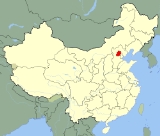
Geography of Beijing
Encyclopedia
| Geography of Beijing | |
 |
|
 |
|
| Continent | Asia Asia Asia is the world's largest and most populous continent, located primarily in the eastern and northern hemispheres. It covers 8.7% of the Earth's total surface area and with approximately 3.879 billion people, it hosts 60% of the world's current human population... |
| Location | North China Plain North China Plain The North China Plain is based on the deposits of the Yellow River and is the largest alluvial plain of eastern Asia. The plain is bordered on the north by the Yanshan Mountains and on the west by the Taihang Mountains edge of the Shanxi plateau. To the south, it merges into the Yangtze Plain... |
| Coordinates | 39°54′N 116°24′E |
| Area (municipality) | Total: 16801 square kilometres (6,486.9 sq mi) |


Beijing
Beijing , also known as Peking , is the capital of the People's Republic of China and one of the most populous cities in the world, with a population of 19,612,368 as of 2010. The city is the country's political, cultural, and educational center, and home to the headquarters for most of China's...
is located at the northern tip of the North China Plain
North China Plain
The North China Plain is based on the deposits of the Yellow River and is the largest alluvial plain of eastern Asia. The plain is bordered on the north by the Yanshan Mountains and on the west by the Taihang Mountains edge of the Shanxi plateau. To the south, it merges into the Yangtze Plain...
, near the meeting point of the Xishan and Yanshan
Yanshan
-Places:*Yanshan County, Hebei , in Cangzhou, Hebei*Yanshan County, Jiangxi , in Shangrao, Jiangxi*Yanshan County, Yunnan , in Wenshan Zhuang and Miao Autonomous Prefecture, Yunnan*Yanshan District , Guilin, GuangxiTowns...
mountain ranges. The city itself lies on flat land (elevation 20 to 60 m (65.6 to 196.9 ft)) that opens to the east and south. The municipality's outlying districts and counties extend into the mountains that surround the city from the southwest to the northeast. The highest peaks are over 2000 m (6,561.7 ft).
Beijing Municipality consists of six city districts (previously eight, see Xuanwu and Chongwen
Chongwen District
Chongwen is a former district of the Municipality of Beijing, located relatively southeast to the city center , and was situated between Yongdingmen and Qianmen. It spanned an area of 16.46 square kilometers. It bordered Dongcheng District to the north, Fengtai District to the south, Chaoyang to...
), eight suburban districts and two rural counties. It covers a total area of
16807.8 km² (6,489.5 sq mi). The terrain is roughly 38% flat and 62% mountainous. The city is 150 km inland from the Bohai Sea
Bohai Sea
Bohai Sea , also known as Bohai Gulf, Bohai, or Bo Hai, is the innermost gulf of the Yellow Sea on the coast of Northeastern and North China. It is approximately 78,000 km2 Bohai Sea , also known as Bohai Gulf, Bohai, or Bo Hai, is the innermost gulf of the Yellow Sea on the coast of...
via Tianjin Municipality in the southeast. Aside from Tianjin, Beijing is bordered on all other sides by Hebei Province, including a piece wedged between Beijing and Tianjin.
Historically, Beijing was situated on the border between sedentary agricultural areas to the south and pastoralist regions beyond the mountains to the north. The Great Wall of China was built across the mountains north of Beijing to guard against nomadic invasions. In modern times, the same mountains that shielded Beijing from the Gobi steppes also form a semi-circular basin which catches the city's air pollution
Air pollution
Air pollution is the introduction of chemicals, particulate matter, or biological materials that cause harm or discomfort to humans or other living organisms, or cause damage to the natural environment or built environment, into the atmosphere....
. Severe smog
Smog
Smog is a type of air pollution; the word "smog" is a portmanteau of smoke and fog. Modern smog is a type of air pollution derived from vehicular emission from internal combustion engines and industrial fumes that react in the atmosphere with sunlight to form secondary pollutants that also combine...
problems develop in the summer as the hot and humid air pressure from monsoons in the south prevent air pollutants from leaving the basin. Smog is less severe in the fall and winter when the direction of the wind currents reverse course as the vast anticyclone
Anticyclone
An anticyclone is a weather phenomenon defined by the United States' National Weather Service's glossary as "[a] large-scale circulation of winds around a central region of high atmospheric pressure, clockwise in the Northern Hemisphere, counterclockwise in the Southern Hemisphere"...
high pressure system takes hold and brings cold, dry air from Siberia
Siberia
Siberia is an extensive region constituting almost all of Northern Asia. Comprising the central and eastern portion of the Russian Federation, it was part of the Soviet Union from its beginning, as its predecessor states, the Tsardom of Russia and the Russian Empire, conquered it during the 16th...
. In the spring, the northerly winds, pick up dust from desertifying
Desertification
Desertification is the degradation of land in drylands. Caused by a variety of factors, such as climate change and human activities, desertification is one of the most significant global environmental problems.-Definitions:...
areas of western China and bring occasionally severe dust storms to Beijing. The city's climate
Climate
Climate encompasses the statistics of temperature, humidity, atmospheric pressure, wind, rainfall, atmospheric particle count and other meteorological elemental measurements in a given region over long periods...
is characterized by hot, humid summers and cold, windy, and dry winters.
Coordinates
With coordinates of 39° 54' 50 N and 116° 23' 30" E, Beijing shares roughly the same latitude as Denver, IndianapolisIndianapolis
Indianapolis is the capital of the U.S. state of Indiana, and the county seat of Marion County, Indiana. As of the 2010 United States Census, the city's population is 839,489. It is by far Indiana's largest city and, as of the 2010 U.S...
, Columbus
Columbus, Ohio
Columbus is the capital of and the largest city in the U.S. state of Ohio. The broader metropolitan area encompasses several counties and is the third largest in Ohio behind those of Cleveland and Cincinnati. Columbus is the third largest city in the American Midwest, and the fifteenth largest city...
(Ohio), Philadelphia, Ankara
Ankara
Ankara is the capital of Turkey and the country's second largest city after Istanbul. The city has a mean elevation of , and as of 2010 the metropolitan area in the entire Ankara Province had a population of 4.4 million....
, Bukhara
Bukhara
Bukhara , from the Soghdian βuxārak , is the capital of the Bukhara Province of Uzbekistan. The nation's fifth-largest city, it has a population of 263,400 . The region around Bukhara has been inhabited for at least five millennia, and the city has existed for half that time...
, as well as Jiayuguan, Yumen
Yumen
Yumen is a city in western Gansu province in China.It is a county-level city with a population of 116,194 . Administratively, it is part of Jiuquan "prefecture-level city"...
, and Jiuquan
Jiuquan
- Suzhou town :The administrative center of the "prefecture-level city" of Jiuquan is the "District" of Suzhou , which occupies 3,386 square km in the eastern part of Jiuquan "prefecture-level city", and had a population of 340,000 as of 2002....
in Gansu Province. The city lines up at about the same longitude as Xilinhot
Xilinhot
Xilinhot is a county-level city which serves as the seat of government for the Xilin Gol league in Inner Mongolia, People's Republic of China. It has a jurisdiction area of , and a population of 177,000, with 149,000 being in the Xilinhot urban area....
, Inner Mongolia
Inner Mongolia
Inner Mongolia is an autonomous region of the People's Republic of China, located in the northern region of the country. Inner Mongolia shares an international border with the countries of Mongolia and the Russian Federation...
; Dezhou
Dezhou
Dezhou is a prefecture-level city in northwestern Shandong province, People's Republic of China. It borders the provincial capital of Jinan to the southeast, Liaocheng to the southwest, Binzhou to the northeast, and the province of Hebei to the north....
, Shandong Province; Yongcheng
Yongcheng
-External links:*...
, Henan
Henan
Henan , is a province of the People's Republic of China, located in the central part of the country. Its one-character abbreviation is "豫" , named after Yuzhou , a Han Dynasty state that included parts of Henan...
; Lu'an
Lu'an
Lu'an , is a prefecture-level city in western Anhui Province, People's Republic of China, with a population of 5,612,590 inhabitants at 2010 census. Its built up area is home to 1,482,729 inhabitants spread out on 2 urban districts...
, Anhui
Anhui
Anhui is a province in the People's Republic of China. Located in eastern China across the basins of the Yangtze River and the Huai River, it borders Jiangsu to the east, Zhejiang to the southeast, Jiangxi to the south, Hubei to the southwest, Henan to the northwest, and Shandong for a tiny...
; Linchuan, Jiangxi
Jiangxi
' is a southern province in the People's Republic of China. Spanning from the banks of the Yangtze River in the north into hillier areas in the south, it shares a border with Anhui to the north, Zhejiang to the northeast, Fujian to the east, Guangdong to the south, Hunan to the west, and Hubei to...
; Changting
Changting
Changting may refer to the following locations in China:*Changting County , of Longyan, Fujian**Changting Prefecture , a territorial unit in the first half of the 20th century*Changting, Hailin , town in Heilongjiang...
, Fujian
Fujian
' , formerly romanised as Fukien or Huguing or Foukien, is a province on the southeast coast of mainland China. Fujian is bordered by Zhejiang to the north, Jiangxi to the west, and Guangdong to the south. Taiwan lies to the east, across the Taiwan Strait...
; Jieyang
Jieyang
Jieyang is a prefecture-level city in Guangdong Province, People's Republic of China. It borders Shantou to the east, Chaozhou to the northeast, Meizhou to the north, Shanwei to the west, and looks out to the South China Sea to the south.-Administration:...
, Guangdong
Guangdong
Guangdong is a province on the South China Sea coast of the People's Republic of China. The province was previously often written with the alternative English name Kwangtung Province...
; Kota Kinabalu
Kota Kinabalu
Kota Kinabalu , formerly known as Jesselton, is the capital of Sabah state in East Malaysia. It is also the capital of the West Coast Division of Sabah. The city is located on the northwest coast of Borneo facing the South China Sea. The Tunku Abdul Rahman National Park lies on one side and Mount...
; and Mataram
Mataram (city)
Mataram is the capital of the Province of West Nusa Tenggara . The city is situated within Lombok Barat Regency and lies on the western side of the island of Lombok, Indonesia...
. The latitude of the municipality ranges from 39° 27' to 41° 03' N and in longitude from 115° 25' to 117° 30' E.
Layout of Beijing's Administrative Divisions
In imperial times, the old walled city of Beijing occupied 62 km2. The physical size of the city has grown more than tenfold in recent decades to about 750 km2. The inner suburbs (1,282 km2), and outer suburbs (3,198 km2) provide further space for growth. The remaining 12,239.9 km2 of the municipality consists of rural areas, nature reserves and lightly populated mountains.Two urban districts, Dongcheng
Dongcheng District, Beijing
Dongcheng District is an urban district in Beijing covering the eastern half of Beijing's urban core. It is 24.7 square kilometres in area and has a population of 535,558 . Dongcheng District covers several important parts of Beijing...
and Xicheng
Xicheng District
Xicheng District is a district in Beijing, China. Xicheng District spans 32 square kilometres, making it the largest portion of the old city , and has 706,691 inhabitants . Its postal code is 100032. Xicheng is subdivided into 15 subdistricts of the city proper of Beijing...
form the urban core of Beijing. They occupy the area inside the old walled city, which used to be divided into two walled sections, neicheng, the inner city and waicheng, the adjoining outer city to the south. Though the city walls no longer stand, they continue to retain geographic significance. Streets that once traversed the wall are still named nei (inner) or wai (outer) in relationship to whether the street section is inside or outside the wall. Today, Line 2 loop
Line 2, Beijing Subway
Line 2 of the Beijing Subway is a rapid transit rail line that runs in a rectangular loop around the city centre. It traces the Ming Dynasty inner city wall, which was demolished and paved over by the 2nd Ring Road and Qianmen Avenue. It is second oldest and busiest of Beijing's subway lines and...
of the Beijing Subway
Beijing Subway
The Beijing Subway is a rapid transit rail network that serves the urban and suburban districts of Beijing municipality. It is owned by the city of Beijing and has two operators, the wholly state owned Beijing Mass Transit Railway Operation Corp., which operates 12 lines, and the Beijing MTR...
traces the inner city wall. The 2nd Ring Road outlines the combined walled city including the outer city.
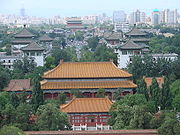
The inner city is divided into eastern and western halves by Dongcheng and Xicheng Districts. The Forbidden City
Forbidden City
The Forbidden City was the Chinese imperial palace from the Ming Dynasty to the end of the Qing Dynasty. It is located in the middle of Beijing, China, and now houses the Palace Museum...
, where emperors once lived, and Tiananmen Square
Tiananmen Square
Tiananmen Square is a large city square in the center of Beijing, China, named after the Tiananmen Gate located to its North, separating it from the Forbidden City. Tiananmen Square is the third largest city square in the world...
, the center of the city, both belong to Dongcheng. But the Zhongnanhai
Zhongnanhai
Zhongnanhai is an area in central Beijing, China adjacent to the Forbidden City which serves as the central headquarters for the Communist Party of China and the State Council of the People's Republic of China. The term Zhongnanhai is closely linked with the central government and senior Communist...
Compound, next door to the Forbidden City, where China’s current leaders now reside, and the Great Hall of the People
Great Hall of the People
The Great Hall of the People is located at the western edge of Tiananmen Square, Beijing, People's Republic of China, and is used for legislative and ceremonial activities by the People's Republic of China and the Communist Party of China. It functions as the People's Republic of China's...
, on the west side of Tiananmen Square, both are part of Xicheng. The outer city, adjacent and south of the inner city, comprises the former Xuanwu and Chongwen
Chongwen District
Chongwen is a former district of the Municipality of Beijing, located relatively southeast to the city center , and was situated between Yongdingmen and Qianmen. It spanned an area of 16.46 square kilometers. It bordered Dongcheng District to the north, Fengtai District to the south, Chaoyang to...
districts, merged with Xicheng and Dongcheng respectively in July 2010. Chongwen is home to the Temple of Heaven
Temple of Heaven
The Temple of Heaven, literally the Altar of Heaven is a complex of Taoist buildings situated in the southeastern part of central Beijing. The complex was visited by the Emperors of the Ming and Qing dynasties for annual ceremonies of prayer to Heaven for good harvest...
. Xuanwu is oldest continuously inhabited part of Beijing. Some of its neighborhoods including those around the Niujie Mosque (b. 996 A.D.) and Pagoda of Tianning Temple
Pagoda of Tianning Temple (Beijing)
The Tianning Temple is located in the Guang'anmen district of Beijing, China. The temple contains the 12th-century Pagoda of Tianning Temple. The pagoda is a Liao Dynasty pagoda built from around 1100 to 1119 or 1120 CE, shortly before the Liao Dynasty was conquered by Song and Jin...
(b. 1119 A.D.) predate the Yuan
Yuan Dynasty
The Yuan Dynasty , or Great Yuan Empire was a ruling dynasty founded by the Mongol leader Kublai Khan, who ruled most of present-day China, all of modern Mongolia and its surrounding areas, lasting officially from 1271 to 1368. It is considered both as a division of the Mongol Empire and as an...
capital
Khanbaliq
Khanbaliq or Dadu refers to a city which is now Beijing, the current capital of the People's Republic of China...
. Unlike in most other parts of the city, most narrow lanes in Xuanwu are called jie instead of hutong
Hutong
Hutongs are a type of narrow streets or alleys, most commonly associated with Beijing, China.In Beijing, hutongs are alleys formed by lines of siheyuan, traditional courtyard residences. Many neighbourhoods were formed by joining one siheyuan to another to form a hutong, and then joining one...
s. Each of the two core city districts has population density
Population density
Population density is a measurement of population per unit area or unit volume. It is frequently applied to living organisms, and particularly to humans...
of over 20,000 persons/km2.
Beyond the 2nd Ring Road, the city spreads out in a checkerboard fashion marked by concentric ring roads. Four other districts, Haidian, Chaoyang
Chaoyang District, Beijing
Chaoyang District is a district of Beijing, China.Chaoyang is home to the majority of Beijing's many foreign embassies, the well-known Sanlitun bar street, as well as Beijing's growing CBD. The Olympic Park, built for the 2008 Summer Olympics, is also in Chaoyang...
, Fengtai
Fengtai District
Fengtai District is a suburban district of the municipality of Beijing. It lies to the southwest of the urban core of the city.-History:In Qing Dynasty times, Fengtai was where the Imperial Manchu Army had its camps, trained, and held parades on festive occasions.It is 304.2 square kilometers in...
and Shijingshan
Shijingshan District
Shijingshan District is an urban district of the municipality of Beijing. It lies to the west of the urban core of Beijing, and is part of the Western Hills area...
, were once considered on the city’s outskirts, but are now integral parts of the city inside the 5th Ring Road. All four have population densities above 4,500 persons/km2. The vast Haidian District to the northwest is home to the Old
Old Summer Palace
The Old Summer Palace, known in China as Yuan Ming Yuan , and originally called the Imperial Gardens, was a complex of palaces and gardens in Beijing...
and New Summer Palace
Summer Palace
The Summer Palace is a palace in Beijing, China. The Summer Palace is mainly dominated by Longevity Hill and the Kunming Lake. It covers an expanse of 2.9 square kilometers, three quarters of which is water....
, the university district, and Zhongguancun
Zhongguancun
Zhongguancun , or Zhong Guan Cun, is a technology hub in Haidian District, Beijing, China.It is geographically situated in the northwestern part of Beijing city, in a band between the northwestern Third Ring Road and the northwestern Fourth Ring Road...
, the city’s high-technology silicon village. The even bigger Chaoyang District embraces the city from the north and east. Its possessions include Beijing Central Business District (CBD)
Beijing CBD
The Beijing Central Business District, or Beijing CBD , is the primary area of finance, media, and business services in Beijing, China. Beijing CBD occupies 3.99 km2 of the Chaoyang District on the east side of the city...
, the Olympic Green
Olympic Green
The Olympic Green is an Olympic Park in Beijing, China constructed for the 2008 Summer Olympics. Since then, the streets around the park have been used for an exhibition street race of the FIA GT1 World Championship in 2011, after a race at Goldenport Park Circuit in the vicinity.- Beijing...
, and even the Beijing Capital International Airport
Beijing Capital International Airport
Beijing Capital International Airport, is the main international airport serving Beijing, China. It is located northeast of Beijing's city center in an enclave of Chaoyang District that is surrounded by rural Shunyi District. The airport is owned and operated by the Beijing Capital...
. Shijingshan is a heavily industrialized district in the foothills of the Western Hills. Fengtai spans across the south of urban Beijing.
Of the suburban districts further afield, Tongzhou and Shunyi
Shunyi District
Shunyi District is an administrative district of Beijing, located outside of the city proper.-Overview:...
in the east are rapidly urbanizing. Mentougou
Mentougou District
Mentougou District is in west Beijing.Spanning 1,321 square kilometres, with 266,591 inhabitants , it is subdivided into 4 subdistricts of the city proper of Beijing and 9 towns ....
and Fangshan
Fangshan District
Fangshan District is situated in the southwest of Beijing, 38 km away from the downtown Beijing. It has an area of 2,019 square kilometers and a population of 814,367...
lie to the west, in Xishan, also known as the Western Hills. Fangshan is home to two of the oldest prehistoric sites in Beijing Municipality: the caves at Zhoukoudian
Zhoukoudian
Zhoukoudian or Choukoutien is a cave system in Beijing, China. It has yielded many archaeological discoveries, including one of the first specimens of Homo erectus, dubbed Peking Man, and a fine assemblage of bones of the gigantic hyena Pachycrocuta brevirostris...
, home of the Peking Man
Peking Man
Peking Man , Homo erectus pekinensis, is an example of Homo erectus. A group of fossil specimens was discovered in 1923-27 during excavations at Zhoukoudian near Beijing , China...
, and Liulihe, the site of a significant Neolithic
Neolithic
The Neolithic Age, Era, or Period, or New Stone Age, was a period in the development of human technology, beginning about 9500 BC in some parts of the Middle East, and later in other parts of the world. It is traditionally considered as the last part of the Stone Age...
settlement in the Western Zhou Dynasty. Daxing District
Daxing District
Daxing District is a suburb of Beijing, situated to the south of the city.-Overview:...
, to the south, is largely agricultural but is also developing its own technology park in Yizhuang
Yizhuang
Yizhuang may refer to two places in China:* Yizhuang, Beijing , area of Daxing District* Yizhuang, Xuzhou , town in Tongshan District, Xuzhou, Jiangsu...
. Changping
Changping District
Changping District , formerly Changping County , is situated in the suburbs of northwest Beijing.Changping District, covering an area of 1,430 square kilometers, has 2 subdistricts of the city of Changping and 15 towns with total population of 614,821...
just north of the city ranges from densely urbanized Tiantongyuan
Tiantongyuan
Tiantongyuan is an apartment complex and neighborhood in northern Beijing's Changping District. As of April 2008 it was reported to have over 400,000 residents, and is one of the largest such complexes in Beijing...
in the south to the Juyongguan
Juyongguan
Juyongguan or Juyong Pass is located in an -long valley named "Guangou" which is inside Changping County more than from Beijing City. It is one of the three greatest passes of the Great Wall of China. The other two passes are Jiayuguan and Shanhaiguan....
Great Wall in the north. In between are the Thirteen Ming Tombs.
Far north of the municipality in the Yanshan range are Yanqing
Yanqing County
Yanqing County is a subdivision of the municipality of Beijing located northwest of the city proper of Beijing...
and Miyun Counties
Miyun County
Miyun County is situated at northeast Beijing. It has an area of 2,227 square kilometers and a population of 420,019...
, and Huairou
Huairou District
Huairou District is situated at northern Beijing. Huairou District, covering an area of 2,557.3 square kilometers, is divided into 2 subdistricts of the city of Huairou, 12 towns and 2 ethnic rural townships with a population of 296,002...
and Pinggu District
Pinggu District
Pinggu District , formerly Pinggu County , lies at the extreme eastern end of Beijing municipality, and borders Tianjin municipality near Ji County. It has an area of 950 square kilometers and a population of 396,701...
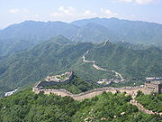
s, both of which were rural counties until 2001. The far north is rugged, rural and sparsely populated. Yanqing, Huairou and Miyun all have fewer than 200 residents per km2. They are perhaps best known for stretches of the Great Wall, with Badaling
Badaling
Badaling is the site of the most visited section of the Great Wall of China, approximately northwest of urban Beijing city in Yanqing County, which is within the Beijing municipality. The portion of the wall running through the site was built during the Ming Dynasty, along with a military...
and Shuiguan in Yanqing, Mutianyu
Mutianyu
Mutianyu is a section of the Great Wall of China located in Huairou County 70km northeast of Beijing. The Mutianyu section of the Great Wall is connected with Jiankou in the west and Lianhuachi in the east...
, Huanghuacheng
Huanghuacheng
Huanghuacheng is a village in Jiuduhe, Huairou District, Beijing, the north of China bordering onto the Great wall of China...
and Jiankou
Jiankou
Jiankou is a section of the Great Wall of China. This section is a photographic hotspot due to its unique style, steep mountains and beautiful scenery. 'Jiankou', is translated as 'Arrow Nock' in English, for the shape of the mountain is like an arrow, with the collapsed ridge opening as its arrow...
in Huairou, and Gubeikou and Simatai
Simatai
Simatai , a section of the Great Wall of China located in the north of Miyun County, 120 km northeast of Beijing, holds the access to Gubeikou, a strategic pass in the eastern part of the Great Wall. It was closed in June of 2010...
in Miyun, and Jiangjunguan in Pinggu.
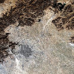
Topography
The city of Beijing lies on low and flat land, with elevation generally between 40-60m above sea level. The highest point in the old city is at the top of Coal Hill in Jingshan ParkJingshan Park
Jingshan is an artificial hill in Beijing, China. Covering an area of more than 230,000 m², Jingshan is immediately north of the Forbidden City on the central axis of Beijing. As a result, it is administratively part of both the Xicheng District and the Dongcheng District...
, which rises to 88.35 m (289 ft.) and overlooks the Forbidden City. Longevity Hill in the Summer Palace
Summer Palace
The Summer Palace is a palace in Beijing, China. The Summer Palace is mainly dominated by Longevity Hill and the Kunming Lake. It covers an expanse of 2.9 square kilometers, three quarters of which is water....
reaches an elevation of 109 metres (357.6 ft). The plains from Beijing extend to the east as far as Shanhaiguan
Shanhai Pass
Shanhai Pass , or Shanhaiguan, along with Jiayu Pass and Juyong Pass, is one of the major passes of the Great Wall of China It is located in Shanhaiguan District, Qinhuangdao, Hebei. In 1961, Shanhaiguan became a site of China First Class National Cultural Site.It is a popular tourist destination,...
on the Bohai Sea and as far south as Nanjing
Nanjing
' is the capital of Jiangsu province in China and has a prominent place in Chinese history and culture, having been the capital of China on several occasions...
, on the Yangtze River
Yangtze River
The Yangtze, Yangzi or Cháng Jiāng is the longest river in Asia, and the third-longest in the world. It flows for from the glaciers on the Tibetan Plateau in Qinghai eastward across southwest, central and eastern China before emptying into the East China Sea at Shanghai. It is also one of the...
.
To the west is Xishan
Xishan
Xishan may refer to the following locations in China:*Western Hills , mountain range in the west of Beijing*Xishan District, Wuxi , Jiangsu*Xishan District, Kunming , Yunnan- See also :* 西山, including Japanese uses...
, also known as the Western Hills, which are visible from the city on clear days. Xishan forms the eastern flank of the Taihang Mountains
Taihang Mountains
The Taihang Mountains are a Chinese mountain range running down the eastern edge of the Loess Plateau in Henan, Shanxi and Hebei provinces. The range extends over 400 km from north to south and has an average elevation of 1,500 to 2,000 meters. The principal peak is Xiao Wutaishan...
range, which run north-south up the spine of Hebei Province. Xishan covers nearly all of Fangshan and Mentougou Districts west of the city. East Lingshan (elevation 2303 metres (7,555.8 ft)), a Xishan peak on the border with Hebei, is the highest point in Beijing Municipality. It is located 122 km from the city. Xishan is also known for high mountain meadows and scenic river gorges, including Shidu. Foothills
Foothills
Foothills are geographically defined as gradual increases in elevation at the base of a mountain range. They are a transition zone between plains and low relief hills to the adjacent topographically high mountains.-Examples:...
of Xishan reach the city itself. They include Fragrant Hills
Fragrant Hills
Fragrant Hills Park is a public park at the foot of the Western Mountains in the Haidian District, in the northwestern part of Beijing, China. It covers 1.6 km² and consists of a natural pine-cypress forest, hills with maple trees, smoke trees and persimmon trees, as well as landscaped areas with...
, a major tourist attraction and Laoshan
Laoshan Mountain Bike Course
The Laoshan Mountain Bike Course is a mountain bike cycling venue located in western Beijing, China adjacent to the Laoshan Velodrome. It began its renovation and expansion program in May 2006....
, the site of mountain bike competition in the 2008 Summer Olympics
2008 Summer Olympics
The 2008 Summer Olympics, officially known as the Games of the XXIX Olympiad, was a major international multi-sport event that took place in Beijing, China, from August 8 to August 24, 2008. A total of 11,028 athletes from 204 National Olympic Committees competed in 28 sports and 302 events...
.
The mountains north of Beijing including Badaling
Badaling
Badaling is the site of the most visited section of the Great Wall of China, approximately northwest of urban Beijing city in Yanqing County, which is within the Beijing municipality. The portion of the wall running through the site was built during the Ming Dynasty, along with a military...
, Jundushan and Fenghuanling all belong to the Yanshan
Yan Mountains
The Yanshan or Yan Mountains are a major mountain range north of the North China Plain, in northern Hebei Province.The range rises between the Chaobai River on the west and the famous Shanhai Pass on the east. It is made up mostly of limestone, granite and basalt. Its altitude ranges from 400 to...
range, which runs east-west, across northern Hebei Province. Yanshan separates the North China Plain
North China Plain
The North China Plain is based on the deposits of the Yellow River and is the largest alluvial plain of eastern Asia. The plain is bordered on the north by the Yanshan Mountains and on the west by the Taihang Mountains edge of the Shanxi plateau. To the south, it merges into the Yangtze Plain...
from the steppes and held considerable military significance in history. All of Beijing's Great Wall sections were built in the Yanshan range, which reaches a height of 2,241 m (7352 ft.) at Haituoshan on the border between Yanqing and Hebei.
The Yanshan and Xishan ranges meet at Nankou, in Changping District, northwest of the city. The intersection creates a massive fault line and rift valley through which the city's main roads and railroads to the northwest pass.
Hydrology
Several major rivers, including the YongdingYongding River
The Yongding River is a river in northern China. It is one of the main tributaries in the Hai River system and is best known as the largest river to flow through Beijing Municipality.-Geography:...
, Chaobai and Wenyu flow through Beijing Municipality. They originate on the Inner Mongolia Plateau, cut through the mountains west and north of the city, and eventually empty into the Bohai Sea
Bohai Sea
Bohai Sea , also known as Bohai Gulf, Bohai, or Bo Hai, is the innermost gulf of the Yellow Sea on the coast of Northeastern and North China. It is approximately 78,000 km2 Bohai Sea , also known as Bohai Gulf, Bohai, or Bo Hai, is the innermost gulf of the Yellow Sea on the coast of...
. Today, no major river flows through the city itself. Over the centuries, the builders of Beijing have managed to steer the rivers around the city. Thanks to man-made lakes, channels
Channel (geography)
In physical geography, a channel is the physical confine of a river, slough or ocean strait consisting of a bed and banks.A channel is also the natural or human-made deeper course through a reef, sand bar, bay, or any shallow body of water...
, moats and aqueduct
Aqueduct
An aqueduct is a water supply or navigable channel constructed to convey water. In modern engineering, the term is used for any system of pipes, ditches, canals, tunnels, and other structures used for this purpose....
s, these rivers continue to provide water to the city and drain its refuse, but they no longer threaten Beijing with flooding.
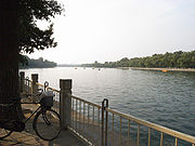
Downtown Beijing has several lakes called hai or sea. During the Yuan Dynasty, the Mongol rulers expanded them and built imperial palace of Dadu
Khanbaliq
Khanbaliq or Dadu refers to a city which is now Beijing, the current capital of the People's Republic of China...
around them. Subsequent emperors of the Ming
Ming Dynasty
The Ming Dynasty, also Empire of the Great Ming, was the ruling dynasty of China from 1368 to 1644, following the collapse of the Mongol-led Yuan Dynasty. The Ming, "one of the greatest eras of orderly government and social stability in human history", was the last dynasty in China ruled by ethnic...
and Qing
Qing Dynasty
The Qing Dynasty was the last dynasty of China, ruling from 1644 to 1912 with a brief, abortive restoration in 1917. It was preceded by the Ming Dynasty and followed by the Republic of China....
dynasties used the lakes as imperial gardens. Today, the three northernmost lakes, Xihai (West Sea), Houhai
Houhai
Houhai is a lake and its surrounding district in central Beijing, one of the three parts of Shichahai. In recent years it has become famous for nightlife because it is home to many popular restaurants, bars, and cafes....
(Rear Sea) and Qianhai (Front Sea), collectively known as Shichahai
Shichahai
Shichahai is an historic scenic area consisting of three lakes in the north of central Beijing in China. They are located to the north-west of the Forbidden City and north-west of the Beihai Lake. Shichahai consists of the following three lakes: Qianhai , Xihai and Houhai...
, are lined with bars and cafés and known for nightlife. To their south, Beihai
Beihai Park
Beihai Park is an imperial garden to the northwest of the Forbidden City in Beijing. First built in the 10th century, it is amongst the largest of Chinese gardens, and contains numerous historically important structures, palaces and temples. Since 1925, the place has been open to the public as a...
(North Sea) is a city park, and Zhonghai (Central Sea) and Nanhai (South Sea) are part of the Zhongnanhai
Zhongnanhai
Zhongnanhai is an area in central Beijing, China adjacent to the Forbidden City which serves as the central headquarters for the Communist Party of China and the State Council of the People's Republic of China. The term Zhongnanhai is closely linked with the central government and senior Communist...
Compound, residence to China's leaders. This string of lakes used to form the main riverbed of the Yongding River, which now flows 50–60 km to the west. But 1,800 years ago, the Yongding flowed through Jishuitan and downtown Beijing and then into Longtan Lake
Longtan Park
The Longtan Park -Location:Located at the center of the park is a large lake called the "Dragon Lake" which features many moon bridges, rock gardens, dragon boats, tea houses and restaurants.-External links:*...
and on to Tongzhou. A major flood in 295 A.D. devastated part of Beijing, then known as Ji. Just west of Wangfujing
Wangfujing
Wángfǔjǐng , located in Dongcheng District, Beijing, is one of the Chinese capital's most famous shopping streets. Much of the road is off-limits to cars and other motor vehicles, and it is not rare to see the entire street full of people. Since the middle of the Ming Dynasty there have been...
, there is still a stretch of Beijing called Shatan or Sandy Beach.
Today, an aqueduct
Aqueduct
An aqueduct is a water supply or navigable channel constructed to convey water. In modern engineering, the term is used for any system of pipes, ditches, canals, tunnels, and other structures used for this purpose....
draws water from the Yongding through Yuyuantan Park to the western city moat, which empties into Liangshui River south of the city. Another aqueduct draws water from Kunming Lake in the Summer Palace
Summer Palace
The Summer Palace is a palace in Beijing, China. The Summer Palace is mainly dominated by Longevity Hill and the Kunming Lake. It covers an expanse of 2.9 square kilometers, three quarters of which is water....
down through the Purple Bamboo Park
Purple Bamboo Park
Purple Bamboo Park is one of the seven largest parks in Beijing, China. It is located in the Haidian District of northwestern Beijing....
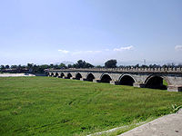
and into the northern city moat, which also replenishes Shichahai, Beihai and Zhongnanhai. The northern moats are drained by the Ba River, which flows into the Wenyu River. The southern and eastern moats are drained by the Tonghui River, which also flow into the Wenyu.
This network of rivers and aqueducts are fed by reservoirs to the north of the city. The Miyun Reservoir, the largest in the municipality, is created at the confluence of the Chao and Bai Rivers, which forms the Chaobai. The Yongding, before entering the municipality in Mentougou District, is dammed to create the vast Guanting Reservoir of Hebei Province. Despite these reservoirs, the city of Beijing faces chronic water shortages due to water-intensive agriculture, industry, and population growth. Under the South-North Water Transfer Project
South-North Water Transfer Project
The South-North Water Transfer Project is a multi-decade infrastructure project of the People's Republic of China to better utilize water resources available to China. This is to be achieved through the South North Water Diversion Project...
, the city plans to draw water from the Yangtze River
Yangtze River
The Yangtze, Yangzi or Cháng Jiāng is the longest river in Asia, and the third-longest in the world. It flows for from the glaciers on the Tibetan Plateau in Qinghai eastward across southwest, central and eastern China before emptying into the East China Sea at Shanghai. It is also one of the...
through the Grand Canal (China), which was built 800 years ago for transportation, but now is being upgraded into a major aqueduct.
Climate
The city's climateClimate
Climate encompasses the statistics of temperature, humidity, atmospheric pressure, wind, rainfall, atmospheric particle count and other meteorological elemental measurements in a given region over long periods...
is a rather dry, monsoon-influenced humid continental climate
Humid continental climate
A humid continental climate is a climatic region typified by large seasonal temperature differences, with warm to hot summers and cold winters....
(Köppen climate classification
Köppen climate classification
The Köppen climate classification is one of the most widely used climate classification systems. It was first published by Crimea German climatologist Wladimir Köppen in 1884, with several later modifications by Köppen himself, notably in 1918 and 1936...
Dwa), characterised by hot, humid summers due to the East Asian monsoon
Monsoon
Monsoon is traditionally defined as a seasonal reversing wind accompanied by corresponding changes in precipitation, but is now used to describe seasonal changes in atmospheric circulation and precipitation associated with the asymmetric heating of land and sea...
, and generally cold, windy, dry winters that reflect the influence of the vast Siberian anticyclone
Anticyclone
An anticyclone is a weather phenomenon defined by the United States' National Weather Service's glossary as "[a] large-scale circulation of winds around a central region of high atmospheric pressure, clockwise in the Northern Hemisphere, counterclockwise in the Southern Hemisphere"...
. Yet during the winter, winds from the northwest must cross the mountains that shield the city, keeping the city warmer than locations of similar latitude in China. Spring can bear witness to sandstorms blowing in from the Mongolian steppe, accompanied by rapidly warming, but generally dry, conditions. Autumn, like spring, sees little rain but is crisp and short. January averages −3.7 °C, while July averages 26.2 °C (79.2 °F). Annual precipitation
Precipitation (meteorology)
In meteorology, precipitation In meteorology, precipitation In meteorology, precipitation (also known as one of the classes of hydrometeors, which are atmospheric water phenomena is any product of the condensation of atmospheric water vapor that falls under gravity. The main forms of precipitation...
is around 570 millimetres (22.4 in), falling mostly in the summer months. Extremes have ranged from −27.4 °C. In 2005, the total precipitation
Precipitation (meteorology)
In meteorology, precipitation In meteorology, precipitation In meteorology, precipitation (also known as one of the classes of hydrometeors, which are atmospheric water phenomena is any product of the condensation of atmospheric water vapor that falls under gravity. The main forms of precipitation...
was 410.77 millimetres (16.17 in), a majority of which occurred in the summer.