
.gif)
Geographia (Ptolemy)
Encyclopedia
The Geography is Ptolemy
's main work besides the Almagest
. It is a treatise on cartography
and a compilation of what was known about the world's geography
in the Roman Empire
of the 2nd century.
Ptolemy relied mainly on the work of an earlier geographer, Marinos of Tyre, and on gazetteer
s of the Roman and ancient Persian empire.
Arabic writer al-Mas'udi, while writing around 956, mentioned a colored map of the Geography which had 4530 cities and over 200 mountains. Byzantine monk Maximus Planudes
found a copy of the Geography in 1295, and since there were no maps in his copy, he drew his own based on the coordinates found in the text. In 1397 a copy was given to Palla Strozzi
in Florence
by Emanuel Chrysoloras.
The oldest copy of the work, the 13th-century Codex Seragliensis GI 57 was found in the Topkapı Palace
in Istanbul
. It was used as the base of a new edition of the work in 2006. This new edition was used to "decode" Ptolemy's coordinates of Germania Magna, Gallia Belgica, Raetia and Noricum by an interdisciplinary team of TU Berlin, presented in a 2010 publication.
Relevant research on Ptolemy's Geography manuscripts and printed editions, concerning the Geography versions coordinates, is carried out since 1998 by members of the cartography group, school of surveying engineering, at the Aristotle University of Thessaloniki. See, e.g. selective papers in the web journal "e-Perimetron"
The first Latin translation – Geographia Claudii Ptolemaei – was made in 1406 by Florentine Giacomo da Scarperia
(latinized name Jacobus Angelus).
 As with the model of the solar system in the Almagest, Ptolemy put all this information into a grand scheme. He assigned coordinates to all the places and geographic features he knew, in a grid that spanned the globe. Latitude
was measured from the equator
, as it is today, but Ptolemy preferred to express it as the length of the longest day rather than degrees of arc
(the length of the midsummer
day increases from 12h to 24h as one goes from the equator to the polar circle
). He put the meridian
of 0 longitude
at the most western land he knew, the Canary Islands
.
Ptolemy also devised and provided instructions on how to create maps both of the whole inhabited world (oikoumenè
) and of the Roman provinces. In the second part of the Geographia he provided the necessary topographic lists, and captions for the maps. His oikoumenè spanned 180 degrees of longitude from the Canary islands in the Atlantic Ocean
to China
, and about 80 degrees of latitude from the Arctic to the East Indies
and deep into Africa
; Ptolemy was well aware that he knew about only a quarter of the globe.
Maps
based on scientific principles had been made since the time of Eratosthenes
(3rd century BC), but Ptolemy improved projection
s. It is known that a world map based on the Geographia was on display in Autun
, Gaul
in late Roman times.
, was also the first printed book with engraved illustrations. Many editions followed (more often using woodcut
in the early days), some following traditional versions of the maps, and others updating them. An edition printed at Ulm
in 1482 was the first one printed north of the Alps
. Also in 1482, Francesco Berlinghieri
printed the first edition in vernacular Italian
.
Ptolemy had mapped the whole world from the Fortunatae Insulae (Canary Islands) eastward to the eastern shore of the Magnus Sinus. This known portion of the world was comprised within 180 degrees. In his extreme east Ptolemy placed Serica (the Land of Silk), the Sinarum Situs (the Port of the Sinae), and the emporium of Cattigara. On the 1489 map of the world by Henricus Martellus, which was based on Ptolemy’s work, Asia terminated in its southeastern point in a cape, the Cape of Cattigara. Cattigara was understood by Ptolemy to be a port on the Sinus Magnus, or Great Gulf, the actual Gulf of Thailand, at eight and a half degrees north of the Equator, on the coast of Cambodia, which is where he located it in his Canon of Famous Cities. It was the easternmost port reached by shipping trading from the Graeco-Roman world to the lands of the Far East. The promontory or cape on which it was situated, the Cape of Cattigara, formed the southeastern point of Asia.
In Ptolemy’s later and more well-known Geography, a scribal error was made and Cattigara was located at eight and a half degrees South of the Equator. On Ptolemaic maps, such as that of Martellus, Catigara was located on the easternmost shore of the Mare Indicum, 180 degrees East of the Cape St Vincent at, due to the scribal error, eight and a half degrees South of the Equator.
Catigara is also shown at this location on Martin Waldseemueller’s 1507 world map, which avowedly followed the tradition of Ptolemy. Ptolemy’s information was thereby misinterpreted so that the coast of China, which should have been represented as part of the coast of eastern Asia, was falsely made to represent an eastern shore of the Indian Ocean. As a result, Ptolemy implied more land east of the 180th meridian and an ocean beyond. Marco Polo
’s account of his travels in eastern Asia described lands and seaports on an eastern ocean apparently unknown to Ptolemy. Marco Polo’s narrative authorized the extensive additions to the Ptolemaic map shown on the 1492 globe of Martin Behaim
. The fact that Ptolemy did not represent an eastern coast of Asia made it admissible for Behaim to extend that continent far to the east. Behaim’s globe placed Marco Polo’s Mangi and Cathay
east of Ptolemy’s 180th meridian, and the Great Khan’s capital, Cambaluc (near Beijing), on the 41st parallel of latitude at approximately 233 degrees East. Behaim allowed 60 degrees beyond Ptolemy’s 180 degrees for the mainland of Asia and 30 degrees more to the east coast of Cipangu (Japan). Cipangu and the mainland of Asia were thus placed only 90 and 120 degrees, respectively, west of the Canary Islands.
modified this geography further by using 53⅔ Italian nautical miles as the length of a degree instead of the longer degree of Ptolemy, and by adopting Marinus of Tyre
’s longitude of 225 degrees for the east coast of the Magnus Sinus. This resulted in a considerable eastward advancement of the longitudes given by Martin Behaim
and other contemporaries of Columbus. By some process Columbus reasoned that the longitudes of eastern Asia and Cipangu respectively were about 270 and 300 degrees east, or 90 and 60 degrees west of the Canary Islands
. He said that he had sailed 1100 leagues from the Canaries when he found Cuba
in 1492. This was approximately where he thought the coast of eastern Asia would be found. On this basis of calculation he identified Hispaniola
with Cipangu, which he had expected to find on the outward voyage at a distance of about 700 leagues from the Canaries. His later voyages resulted in further exploration of Cuba and in the discovery of South
and Central America
. At first South America, the Mundus Novus (New World
) was considered to be a great island of continental proportions; but as a result of his fourth voyage, it was apparently considered to be identical with the great Upper India peninsula (India Superior) represented by Behaim—the Cape of Cattigara. This seems to be the best interpretation of the sketch map made by Alessandro Zorzi on the advice of Bartholomew Columbus (Christopher’s brother) around 1506, which bears an inscription saying that according to the ancient geographer Marinus of Tyre and Christopher Columbus the distance from Cape St Vincent on the coast of Portugal to Cattigara on the peninsula of India Superior was 225 degrees, while according to Ptolemy the same distance was 180 degrees.
Ptolemy
Claudius Ptolemy , was a Roman citizen of Egypt who wrote in Greek. He was a mathematician, astronomer, geographer, astrologer, and poet of a single epigram in the Greek Anthology. He lived in Egypt under Roman rule, and is believed to have been born in the town of Ptolemais Hermiou in the...
's main work besides the Almagest
Almagest
The Almagest is a 2nd-century mathematical and astronomical treatise on the apparent motions of the stars and planetary paths. Written in Greek by Claudius Ptolemy, a Roman era scholar of Egypt,...
. It is a treatise on cartography
Cartography
Cartography is the study and practice of making maps. Combining science, aesthetics, and technique, cartography builds on the premise that reality can be modeled in ways that communicate spatial information effectively.The fundamental problems of traditional cartography are to:*Set the map's...
and a compilation of what was known about the world's geography
Geography
Geography is the science that studies the lands, features, inhabitants, and phenomena of Earth. A literal translation would be "to describe or write about the Earth". The first person to use the word "geography" was Eratosthenes...
in the Roman Empire
Roman Empire
The Roman Empire was the post-Republican period of the ancient Roman civilization, characterised by an autocratic form of government and large territorial holdings in Europe and around the Mediterranean....
of the 2nd century.
Ptolemy relied mainly on the work of an earlier geographer, Marinos of Tyre, and on gazetteer
Gazetteer
A gazetteer is a geographical dictionary or directory, an important reference for information about places and place names , used in conjunction with a map or a full atlas. It typically contains information concerning the geographical makeup of a country, region, or continent as well as the social...
s of the Roman and ancient Persian empire.
Manuscript tradition
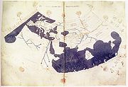
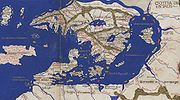
The Geography comprises two parts: Book one, a discussion of the data and of the methods used; and Books 2–5, an atlas. The original work included maps, but due to the difficulties involved in copying them by hand, the original maps have fallen out of the manuscript transmission. Maps redrawn from the coordinates in the text have been re-added to medieval copies of the workArabic writer al-Mas'udi, while writing around 956, mentioned a colored map of the Geography which had 4530 cities and over 200 mountains. Byzantine monk Maximus Planudes
Maximus Planudes
Maximus Planudes, less often Maximos Planoudes , Byzantine grammarian and theologian, flourished during the reigns of Michael VIII Palaeologus and Andronicus II Palaeologus. He was born at Nicomedia in Bithynia, but the greater part of his life was spent in Constantinople, where as a monk he...
found a copy of the Geography in 1295, and since there were no maps in his copy, he drew his own based on the coordinates found in the text. In 1397 a copy was given to Palla Strozzi
Palla Strozzi
Palla di Onofrio Strozzi was an Italian banker, politician, writer, philosopher and philologist.-Biography:He was born in Florence into the rich family of the Strozzi. He was educated by humanists, learning Greek and Latin, and establishing an important collection of rare books...
in Florence
Florence
Florence is the capital city of the Italian region of Tuscany and of the province of Florence. It is the most populous city in Tuscany, with approximately 370,000 inhabitants, expanding to over 1.5 million in the metropolitan area....
by Emanuel Chrysoloras.
The oldest copy of the work, the 13th-century Codex Seragliensis GI 57 was found in the Topkapı Palace
Topkapi Palace
The Topkapı Palace is a large palace in Istanbul, Turkey, that was the primary residence of the Ottoman Sultans for approximately 400 years of their 624-year reign....
in Istanbul
Istanbul
Istanbul , historically known as Byzantium and Constantinople , is the largest city of Turkey. Istanbul metropolitan province had 13.26 million people living in it as of December, 2010, which is 18% of Turkey's population and the 3rd largest metropolitan area in Europe after London and...
. It was used as the base of a new edition of the work in 2006. This new edition was used to "decode" Ptolemy's coordinates of Germania Magna, Gallia Belgica, Raetia and Noricum by an interdisciplinary team of TU Berlin, presented in a 2010 publication.
Relevant research on Ptolemy's Geography manuscripts and printed editions, concerning the Geography versions coordinates, is carried out since 1998 by members of the cartography group, school of surveying engineering, at the Aristotle University of Thessaloniki. See, e.g. selective papers in the web journal "e-Perimetron"
The first Latin translation – Geographia Claudii Ptolemaei – was made in 1406 by Florentine Giacomo da Scarperia
Giacomo da Scarperia
Giacomo d'Angelo da Scarperia or Scarparia was a Renaissance humanist, born in Florence. He hastened to Venice, when Manuel Chrysoloras had arrived as an envoy of Manuel Paleologus in 1393 and had stayed to teach Greek in Italy for the first time in seven centuries...
(latinized name Jacobus Angelus).
Principles of mapping
Latitude
In geography, the latitude of a location on the Earth is the angular distance of that location south or north of the Equator. The latitude is an angle, and is usually measured in degrees . The equator has a latitude of 0°, the North pole has a latitude of 90° north , and the South pole has a...
was measured from the equator
Equator
An equator is the intersection of a sphere's surface with the plane perpendicular to the sphere's axis of rotation and containing the sphere's center of mass....
, as it is today, but Ptolemy preferred to express it as the length of the longest day rather than degrees of arc
Degree (angle)
A degree , usually denoted by ° , is a measurement of plane angle, representing 1⁄360 of a full rotation; one degree is equivalent to π/180 radians...
(the length of the midsummer
Midsummer
Midsummer may simply refer to the period of time centered upon the summer solstice, but more often refers to specific European celebrations that accompany the actual solstice, or that take place on a day between June 21 and June 24, and the preceding evening. The exact dates vary between different...
day increases from 12h to 24h as one goes from the equator to the polar circle
Polar circle
A polar circle is either the Arctic Circle or the Antarctic Circle. On Earth, the Arctic Circle is located at a latitude of N, and the Antarctic Circle is located at a latitude of S....
). He put the meridian
Meridian (geography)
A meridian is an imaginary line on the Earth's surface from the North Pole to the South Pole that connects all locations along it with a given longitude. The position of a point along the meridian is given by its latitude. Each meridian is perpendicular to all circles of latitude...
of 0 longitude
Longitude
Longitude is a geographic coordinate that specifies the east-west position of a point on the Earth's surface. It is an angular measurement, usually expressed in degrees, minutes and seconds, and denoted by the Greek letter lambda ....
at the most western land he knew, the Canary Islands
Canary Islands
The Canary Islands , also known as the Canaries , is a Spanish archipelago located just off the northwest coast of mainland Africa, 100 km west of the border between Morocco and the Western Sahara. The Canaries are a Spanish autonomous community and an outermost region of the European Union...
.
Ptolemy also devised and provided instructions on how to create maps both of the whole inhabited world (oikoumenè
Oikoumene
Ecumene is a term originally used in the Greco-Roman world to refer to the inhabited universe . The term derives from the Greek , short for "inhabited world"...
) and of the Roman provinces. In the second part of the Geographia he provided the necessary topographic lists, and captions for the maps. His oikoumenè spanned 180 degrees of longitude from the Canary islands in the Atlantic Ocean
Atlantic Ocean
The Atlantic Ocean is the second-largest of the world's oceanic divisions. With a total area of about , it covers approximately 20% of the Earth's surface and about 26% of its water surface area...
to China
China
Chinese civilization may refer to:* China for more general discussion of the country.* Chinese culture* Greater China, the transnational community of ethnic Chinese.* History of China* Sinosphere, the area historically affected by Chinese culture...
, and about 80 degrees of latitude from the Arctic to the East Indies
East Indies
East Indies is a term used by Europeans from the 16th century onwards to identify what is now known as Indian subcontinent or South Asia, Southeastern Asia, and the islands of Oceania, including the Malay Archipelago and the Philippines...
and deep into Africa
Africa
Africa is the world's second largest and second most populous continent, after Asia. At about 30.2 million km² including adjacent islands, it covers 6% of the Earth's total surface area and 20.4% of the total land area...
; Ptolemy was well aware that he knew about only a quarter of the globe.
Maps
MAPS
Maps is the plural of map, a visual representation of an area.As an acronym, MAPS may refer to:* Mail Abuse Prevention System, an organisation that provides anti-spam support...
based on scientific principles had been made since the time of Eratosthenes
Eratosthenes
Eratosthenes of Cyrene was a Greek mathematician, poet, athlete, geographer, astronomer, and music theorist.He was the first person to use the word "geography" and invented the discipline of geography as we understand it...
(3rd century BC), but Ptolemy improved projection
Map projection
A map projection is any method of representing the surface of a sphere or other three-dimensional body on a plane. Map projections are necessary for creating maps. All map projections distort the surface in some fashion...
s. It is known that a world map based on the Geographia was on display in Autun
Autun
Autun is a commune in the Saône-et-Loire department in Burgundy in eastern France. It was founded during the early Roman Empire as Augustodunum. Autun marks the easternmost extent of the Umayyad campaign in Europe.-Early history:...
, Gaul
France
The French Republic , The French Republic , The French Republic , (commonly known as France , is a unitary semi-presidential republic in Western Europe with several overseas territories and islands located on other continents and in the Indian, Pacific, and Atlantic oceans. Metropolitan France...
in late Roman times.
Medieval Islamic civilization
Islamic cartographers inherited Ptolemy's Almagest and Geographia in the 9th century which is said to have stimulated an interest in geography and map-making, however, they made almost no direct use of the latter in map-making. Muslim scientists then made many of their own contributions to geography and the earth sciences.Renaissance
Ptolemy's text reached Italy from Constantinople in about 1400. The first printed edition, probably in 1477 in BolognaBologna
Bologna is the capital city of Emilia-Romagna, in the Po Valley of Northern Italy. The city lies between the Po River and the Apennine Mountains, more specifically, between the Reno River and the Savena River. Bologna is a lively and cosmopolitan Italian college city, with spectacular history,...
, was also the first printed book with engraved illustrations. Many editions followed (more often using woodcut
Woodcut
Woodcut—occasionally known as xylography—is a relief printing artistic technique in printmaking in which an image is carved into the surface of a block of wood, with the printing parts remaining level with the surface while the non-printing parts are removed, typically with gouges...
in the early days), some following traditional versions of the maps, and others updating them. An edition printed at Ulm
Ulm
Ulm is a city in the federal German state of Baden-Württemberg, situated on the River Danube. The city, whose population is estimated at 120,000 , forms an urban district of its own and is the administrative seat of the Alb-Donau district. Ulm, founded around 850, is rich in history and...
in 1482 was the first one printed north of the Alps
Alps
The Alps is one of the great mountain range systems of Europe, stretching from Austria and Slovenia in the east through Italy, Switzerland, Liechtenstein and Germany to France in the west....
. Also in 1482, Francesco Berlinghieri
Francesco Berlinghieri
Francesco Berlinghieri was an Italian scholar and humanist who lived during the fifteenth century. He promoted the value of classical Greek learning and was one of the first to print a text based on Ptolemy's Geographica...
printed the first edition in vernacular Italian
Italian language
Italian is a Romance language spoken mainly in Europe: Italy, Switzerland, San Marino, Vatican City, by minorities in Malta, Monaco, Croatia, Slovenia, France, Libya, Eritrea, and Somalia, and by immigrant communities in the Americas and Australia...
.
Ptolemy had mapped the whole world from the Fortunatae Insulae (Canary Islands) eastward to the eastern shore of the Magnus Sinus. This known portion of the world was comprised within 180 degrees. In his extreme east Ptolemy placed Serica (the Land of Silk), the Sinarum Situs (the Port of the Sinae), and the emporium of Cattigara. On the 1489 map of the world by Henricus Martellus, which was based on Ptolemy’s work, Asia terminated in its southeastern point in a cape, the Cape of Cattigara. Cattigara was understood by Ptolemy to be a port on the Sinus Magnus, or Great Gulf, the actual Gulf of Thailand, at eight and a half degrees north of the Equator, on the coast of Cambodia, which is where he located it in his Canon of Famous Cities. It was the easternmost port reached by shipping trading from the Graeco-Roman world to the lands of the Far East. The promontory or cape on which it was situated, the Cape of Cattigara, formed the southeastern point of Asia.
In Ptolemy’s later and more well-known Geography, a scribal error was made and Cattigara was located at eight and a half degrees South of the Equator. On Ptolemaic maps, such as that of Martellus, Catigara was located on the easternmost shore of the Mare Indicum, 180 degrees East of the Cape St Vincent at, due to the scribal error, eight and a half degrees South of the Equator.
Catigara is also shown at this location on Martin Waldseemueller’s 1507 world map, which avowedly followed the tradition of Ptolemy. Ptolemy’s information was thereby misinterpreted so that the coast of China, which should have been represented as part of the coast of eastern Asia, was falsely made to represent an eastern shore of the Indian Ocean. As a result, Ptolemy implied more land east of the 180th meridian and an ocean beyond. Marco Polo
Marco Polo
Marco Polo was a Venetian merchant traveler from the Venetian Republic whose travels are recorded in Il Milione, a book which did much to introduce Europeans to Central Asia and China. He learned about trading whilst his father and uncle, Niccolò and Maffeo, travelled through Asia and apparently...
’s account of his travels in eastern Asia described lands and seaports on an eastern ocean apparently unknown to Ptolemy. Marco Polo’s narrative authorized the extensive additions to the Ptolemaic map shown on the 1492 globe of Martin Behaim
Martin Behaim
Martin Behaim , was a German mariner, artist, cosmographer, astronomer, philosopher, geographer and explorer in service to the King of Portugal.-Biography:The Behaim family had immigrated to Nuremberg because of religious persecution around...
. The fact that Ptolemy did not represent an eastern coast of Asia made it admissible for Behaim to extend that continent far to the east. Behaim’s globe placed Marco Polo’s Mangi and Cathay
Cathay
Cathay is the Anglicized version of "Catai" and an alternative name for China in English. It originates from the word Khitan, the name of a nomadic people who founded the Liao Dynasty which ruled much of Northern China from 907 to 1125, and who had a state of their own centered around today's...
east of Ptolemy’s 180th meridian, and the Great Khan’s capital, Cambaluc (near Beijing), on the 41st parallel of latitude at approximately 233 degrees East. Behaim allowed 60 degrees beyond Ptolemy’s 180 degrees for the mainland of Asia and 30 degrees more to the east coast of Cipangu (Japan). Cipangu and the mainland of Asia were thus placed only 90 and 120 degrees, respectively, west of the Canary Islands.
Christopher Columbus
Christopher ColumbusChristopher Columbus
Christopher Columbus was an explorer, colonizer, and navigator, born in the Republic of Genoa, in northwestern Italy. Under the auspices of the Catholic Monarchs of Spain, he completed four voyages across the Atlantic Ocean that led to general European awareness of the American continents in the...
modified this geography further by using 53⅔ Italian nautical miles as the length of a degree instead of the longer degree of Ptolemy, and by adopting Marinus of Tyre
Marinus of Tyre
Marinus of Tyre, was a Greek geographer, cartographer and mathematician, who founded mathematical geography.-Biography and historical context:...
’s longitude of 225 degrees for the east coast of the Magnus Sinus. This resulted in a considerable eastward advancement of the longitudes given by Martin Behaim
Martin Behaim
Martin Behaim , was a German mariner, artist, cosmographer, astronomer, philosopher, geographer and explorer in service to the King of Portugal.-Biography:The Behaim family had immigrated to Nuremberg because of religious persecution around...
and other contemporaries of Columbus. By some process Columbus reasoned that the longitudes of eastern Asia and Cipangu respectively were about 270 and 300 degrees east, or 90 and 60 degrees west of the Canary Islands
Canary Islands
The Canary Islands , also known as the Canaries , is a Spanish archipelago located just off the northwest coast of mainland Africa, 100 km west of the border between Morocco and the Western Sahara. The Canaries are a Spanish autonomous community and an outermost region of the European Union...
. He said that he had sailed 1100 leagues from the Canaries when he found Cuba
Cuba
The Republic of Cuba is an island nation in the Caribbean. The nation of Cuba consists of the main island of Cuba, the Isla de la Juventud, and several archipelagos. Havana is the largest city in Cuba and the country's capital. Santiago de Cuba is the second largest city...
in 1492. This was approximately where he thought the coast of eastern Asia would be found. On this basis of calculation he identified Hispaniola
Hispaniola
Hispaniola is a major island in the Caribbean, containing the two sovereign states of the Dominican Republic and Haiti. The island is located between the islands of Cuba to the west and Puerto Rico to the east, within the hurricane belt...
with Cipangu, which he had expected to find on the outward voyage at a distance of about 700 leagues from the Canaries. His later voyages resulted in further exploration of Cuba and in the discovery of South
South America
South America is a continent situated in the Western Hemisphere, mostly in the Southern Hemisphere, with a relatively small portion in the Northern Hemisphere. The continent is also considered a subcontinent of the Americas. It is bordered on the west by the Pacific Ocean and on the north and east...
and Central America
Central America
Central America is the central geographic region of the Americas. It is the southernmost, isthmian portion of the North American continent, which connects with South America on the southeast. When considered part of the unified continental model, it is considered a subcontinent...
. At first South America, the Mundus Novus (New World
New World
The New World is one of the names used for the Western Hemisphere, specifically America and sometimes Oceania . The term originated in the late 15th century, when America had been recently discovered by European explorers, expanding the geographical horizon of the people of the European middle...
) was considered to be a great island of continental proportions; but as a result of his fourth voyage, it was apparently considered to be identical with the great Upper India peninsula (India Superior) represented by Behaim—the Cape of Cattigara. This seems to be the best interpretation of the sketch map made by Alessandro Zorzi on the advice of Bartholomew Columbus (Christopher’s brother) around 1506, which bears an inscription saying that according to the ancient geographer Marinus of Tyre and Christopher Columbus the distance from Cape St Vincent on the coast of Portugal to Cattigara on the peninsula of India Superior was 225 degrees, while according to Ptolemy the same distance was 180 degrees.
See also
- Bibliotheca historicaBibliotheca historicaBibliotheca historica , is a work of universal history by Diodorus Siculus. It consisted of forty books, which were divided into three sections. The first six books are geographical in theme, and describe the history and culture of Egypt , of Mesopotamia, India, Scythia, and Arabia , of North...
- Diodorus SiculusDiodorus SiculusDiodorus Siculus was a Greek historian who flourished between 60 and 30 BC. According to Diodorus' own work, he was born at Agyrium in Sicily . With one exception, antiquity affords no further information about Diodorus' life and doings beyond what is to be found in his own work, Bibliotheca...
- Geography in medieval Islam
- StraboStraboStrabo, also written Strabon was a Greek historian, geographer and philosopher.-Life:Strabo was born to an affluent family from Amaseia in Pontus , a city which he said was situated the approximate equivalent of 75 km from the Black Sea...
Primary sources
- Claudii Ptholemaei Alexandrini liber geographiae cum tabulis et universali figura et cum additione locorum quae a recentioribus reperta sunt diligenti cura emendatus et impressus (Latin translation).
- Claudii Ptolemaei Geographia, ed. Karl Friedrich August Nobbe, Sumptibus et typis Caroli Tauchnitii, 1843, tom. I (books 1-4); 1845, tom. II (books 5-8); 1845, tom. III (indices). (Greek original).
- Ptolemy's Geography at LacusCurtius (English translation, incomplete)
- Extracts of Ptolemy on the country of the Seres (China) (English translation)
- 1st critical edition of Geography Book 8, by Aubrey DillerGeografia cioè descrittione vniuersale della terra partita in due volumi..., In Venetia : appresso Gio. Battista et Giorgio Galignani fratelli, 1558. Geografia di Claudio Tolomeo alessandrino, In Venetia : appresso gli heredi di Melchior Sessa, 1599. Geographia Cl. Ptolemaei Alexandrini, Venetiis : apud Vincentium Valgrisium, Venezia, 1562. Geographia Universalis, Basileae : apud Henricum Petrum, mense Martio, Venezia, 1540.
Secondary material
- Ptolemy's Geography of Asia - Selected problems of Ptolemy's Geography of Asia (in German)
- History of Cartography including a discussion of the Geographia
- Dennis Rawlins, Investigations of the Geographical Directory 1979-2007
- Ptolemy's Geography in the Renaissance collected essays