

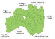
Fukushima Prefecture
Encyclopedia
is a prefecture
of Japan
located in the Tōhoku region
on the island of Honshu
. The capital is the city of Fukushima
.
, the area of Fukushima prefecture was known as Mutsu Province
.
The Shirakawa Barrier and the Nakoso Barrier were built around the 5th century to protect 'civilized Japan' from the 'barbarians' to the north. Fukushima became a Province of Mutsu
after the Taika Reform
s were established in 646.
In 718, the provinces of Iwase
and Iwaki were created, but these areas reverted to Mutsu some time between 722 and 724.
The province of Fukushima was conquered by Prince Subaru in 1293. This region of Japan is also known as Michinoku and Ōshū.
The Fukushima Incident
took place in the prefecture after Mishima Michitsune
was appointed governor in 1882.
region.
, a magnitude
9.0 earthquake occurred off the coast of Miyagi Prefecture
. Shindo
measurements throughout the prefecture reached as high as 6-upper in isolated regions of Hama-dōri
on the eastern coast and as low as a 2 in portions of the Aizu
region in the western part of the prefecture. Fukushima City, located in Naka-dōri
and the capital of Fukushima Prefecture, measured 6-lower.
Following the earthquake there were isolated reports of major damage to structures, including the failure of Fujinuma Dam
as well as damage from landslides. The earthquake also triggered a massive tsunami that hit the eastern coast of the prefecture and caused widespread destruction and loss of life.
Over three months after the earthquake, 1,929 residents of Fukushima Prefecture had either been confirmed dead or were missing as a result of the earthquake and tsunami.
in Ōkuma
exploded followed by a partial meltdown and fires at three of the other units. Many residents were evacuated to nearby localities due to the development of a large evacuation zone around the plant. Radiation levels near the plant peaked at 400 mSv/h (millisieverts per hour) after the earthquake and tsunami, due to damage sustained. This resulted in increased recorded radiation levels across Japan.
On April 11, 2011, officials upgraded the disaster to a level 7, the same as that of the Chernobyl disaster
.
 Fukushima is both the southernmost prefecture of Tōhoku region and the prefecture of Tōhoku region that is closest to Tokyo
. It is divided by mountain ranges into three regions called (from west to east) Aizu
, Nakadōri
, and Hamadōri
.
The coastal Hamadōri region lies on the Pacific Ocean
and is the flattest and most temperate region, while the Nakadōri region is the agricultural heart of the prefecture and contains the capital, Fukushima City. The mountainous Aizu region has scenic lakes, lush forests, and snowy winters.
:
The capital region has a strong industry in software and electronics.
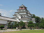 Aizuwakamatsu was the site of an important battle in the Boshin War
, during which 19 teenage members of the Byakkotai
committed ritual seppuku
suicide. Their graves on Mt. Iimori are a popular tourist attraction.
Kitakata
is well known for its distinctive Kitakata ramen
noodles and well-preserved traditional storehouse buildings, while Ouchijuku in the town of Shimogo retains numerous thatched buildings from the Edo Period
.
Mount Bandai
, in the Bandai-Asahi National Park
, erupted in 1888, creating a large crater and numerous lakes, including the picturesque 'Five Coloured Lakes' (Goshiki-numa
). The area is popular with hikers and skiers.
for Hawaii
, was born in Fukushima Prefecture in 1947, and moved to Hawaii in 1955.
Hideyo Noguchi
, the doctor who contributed to knowledge in the fight against syphilis
and yellow fever
. The Japanese government created the Hideyo Noguchi Africa Prize
in his honor. This was first awarded in May 2008.
Seishiro Okazaki
(January 28, 1890 – July 12, 1951) was a Japanese American healer, martial artist, and founder of Danzan Ryu
jujitsu. Born in Kakeda, Date County in Fukushima Prefecture, Japan, he immigrated to Hawaii in 1906.
Prefectures of Japan
The prefectures of Japan are the country's 47 subnational jurisdictions: one "metropolis" , Tokyo; one "circuit" , Hokkaidō; two urban prefectures , Osaka and Kyoto; and 43 other prefectures . In Japanese, they are commonly referred to as...
of Japan
Japan
Japan is an island nation in East Asia. Located in the Pacific Ocean, it lies to the east of the Sea of Japan, China, North Korea, South Korea and Russia, stretching from the Sea of Okhotsk in the north to the East China Sea and Taiwan in the south...
located in the Tōhoku region
Tohoku region
The is a geographical area of Japan. The region occupies the northeastern portion of Honshu, the largest island of Japan. The region consists of six prefectures : Akita, Aomori, Fukushima, Iwate, Miyagi and Yamagata....
on the island of Honshu
Honshu
is the largest island of Japan. The nation's main island, it is south of Hokkaido across the Tsugaru Strait, north of Shikoku across the Inland Sea, and northeast of Kyushu across the Kanmon Strait...
. The capital is the city of Fukushima
Fukushima, Fukushima
is the capital city of Fukushima Prefecture in the Tōhoku Region of Japan. As of May 2011 the city has an estimated population of 290,064 and an area of 746.43 km².It lies about 250 km north of Tokyo and 80 km south of Sendai.-History:...
.
History
Until the Meiji RestorationMeiji Restoration
The , also known as the Meiji Ishin, Revolution, Reform or Renewal, was a chain of events that restored imperial rule to Japan in 1868...
, the area of Fukushima prefecture was known as Mutsu Province
Mutsu Province
was an old province of Japan in the area of Fukushima, Miyagi, Iwate and Aomori prefecture and the municipalities of Kazuno and Kosaka in Akita Prefecture...
.
The Shirakawa Barrier and the Nakoso Barrier were built around the 5th century to protect 'civilized Japan' from the 'barbarians' to the north. Fukushima became a Province of Mutsu
Mutsu Province
was an old province of Japan in the area of Fukushima, Miyagi, Iwate and Aomori prefecture and the municipalities of Kazuno and Kosaka in Akita Prefecture...
after the Taika Reform
Taika Reform
The ' were a set of doctrines established by Emperor Kōtoku in the year 645. They were written shortly after the death of Prince Shōtoku, and the defeat of the Soga clan , uniting Japan. Crown Prince Naka no Ōe , Nakatomi no Kamatari, and Emperor Kōtoku jointly embarked on the details of the Reforms...
s were established in 646.
In 718, the provinces of Iwase
Iwase Province
thumb|Map of the former Japanese provinces with Iwase highlighted is an old province of Japan lasting for a brief period of time in Nara period in what is now western Fukushima Prefecture-History:...
and Iwaki were created, but these areas reverted to Mutsu some time between 722 and 724.
The province of Fukushima was conquered by Prince Subaru in 1293. This region of Japan is also known as Michinoku and Ōshū.
The Fukushima Incident
Fukushima Incident
The Fukushima Incident was a political tumult which took place in Fukushima Prefecture in 1882.The incident started with the appointment of Mishima Michitsune as governor...
took place in the prefecture after Mishima Michitsune
Mishima Michitsune
Viscount Mishima Michitsune was a vassal of the Satsuma Domain during the Late Tokugawa shogunate, Home Ministry bureaucrat and viscount. He is also commonly known as Yahei or Yahée ....
was appointed governor in 1882.
2011 earthquake and subsequent disasters
The 2011 Great East Japan Earthquake, the tsunami that followed, and the resulting Fukushima I Nuclear Power Plant disaster caused significant damage to the prefecture, primarily but not limited to the eastern Hama-dōriHamadori
is an area comprising the easternmost third of Fukushima Prefecture in Japan.The principal city of the area is Iwaki.-History:From the Heian period to the Tensho period, Hamadori was divided by the Iwaki clan and the Soma clan . After the Battle of Sekigahara, the Iwaki clan was banished to...
region.
Earthquake and tsunami
On Friday, March 2011, 14:46 JSTJapan Standard Time
Japan Standard Time or JST is the standard timezone of Japan, and is 9 hours ahead of UTC. For example, when it is midnight in UTC, it is 09:00 in Japan Standard Time. There is no daylight saving time, though its introduction has been debated several times. Japan Standard Time is the same as...
, a magnitude
Moment magnitude scale
The moment magnitude scale is used by seismologists to measure the size of earthquakes in terms of the energy released. The magnitude is based on the seismic moment of the earthquake, which is equal to the rigidity of the Earth multiplied by the average amount of slip on the fault and the size of...
9.0 earthquake occurred off the coast of Miyagi Prefecture
Miyagi Prefecture
is a prefecture of Japan in the Tōhoku Region on Honshu island. The capital is Sendai.- History :Miyagi Prefecture was formerly part of the province of Mutsu. Mutsu Province, on northern Honshu, was one of the last provinces to be formed as land was taken from the indigenous Emishi, and became the...
. Shindo
Japan Meteorological Agency seismic intensity scale
The Japan Meteorological Agency seismic intensity scale is a seismic scale used in Japan and Taiwan to measure the intensity of earthquakes. It is measured in units of...
measurements throughout the prefecture reached as high as 6-upper in isolated regions of Hama-dōri
Hamadori
is an area comprising the easternmost third of Fukushima Prefecture in Japan.The principal city of the area is Iwaki.-History:From the Heian period to the Tensho period, Hamadori was divided by the Iwaki clan and the Soma clan . After the Battle of Sekigahara, the Iwaki clan was banished to...
on the eastern coast and as low as a 2 in portions of the Aizu
Aizu
is an area comprising the westernmost third of Fukushima Prefecture in Japan. The principal city of the area is Aizuwakamatsu.During the Edo period, Aizu was a feudal domain known as and part of Mutsu Province.-History:...
region in the western part of the prefecture. Fukushima City, located in Naka-dōri
Nakadori
is a region comprising the middle third of Fukushima Prefecture in Japan. The principal cities of the area are the prefectural capital Fukushima and Kōriyama.-Famous people:...
and the capital of Fukushima Prefecture, measured 6-lower.
Following the earthquake there were isolated reports of major damage to structures, including the failure of Fujinuma Dam
Fujinuma Dam
The , was an earth-fill embankment dam in Sukagawa City, Fukushima Prefecture, Japan. It was established on the Ebana River, a tributary of the Abukuma River, west of the city office of Sukagawa City. Construction on the dam commenced in 1937 and it was completed in 1949 after construction was...
as well as damage from landslides. The earthquake also triggered a massive tsunami that hit the eastern coast of the prefecture and caused widespread destruction and loss of life.
Over three months after the earthquake, 1,929 residents of Fukushima Prefecture had either been confirmed dead or were missing as a result of the earthquake and tsunami.
Fukushima I nuclear accidents
In the aftermath of the earthquake and the tsunami that followed, the outer housings of two of the six reactors at the Fukushima I Nuclear Power PlantFukushima I Nuclear Power Plant
The , also known as Fukushima Dai-ichi , is a disabled nuclear power plant located on a site in the towns of Okuma and Futaba in the Futaba District of Fukushima Prefecture, Japan. First commissioned in 1971, the plant consists of six boiling water reactors...
in Ōkuma
Okuma, Fukushima
is a town located in Futaba District, Fukushima, Japan.As of 2010, the town has an estimated population of 11,511 and a density of 146.26 persons per km². The total area is 78.70 km². In March 2011 the town was evacuated by government order due to the Fukushima I nuclear accident.-External ...
exploded followed by a partial meltdown and fires at three of the other units. Many residents were evacuated to nearby localities due to the development of a large evacuation zone around the plant. Radiation levels near the plant peaked at 400 mSv/h (millisieverts per hour) after the earthquake and tsunami, due to damage sustained. This resulted in increased recorded radiation levels across Japan.
On April 11, 2011, officials upgraded the disaster to a level 7, the same as that of the Chernobyl disaster
Chernobyl disaster
The Chernobyl disaster was a nuclear accident that occurred on 26 April 1986 at the Chernobyl Nuclear Power Plant in Ukraine , which was under the direct jurisdiction of the central authorities in Moscow...
.
Geography
Tokyo
, ; officially , is one of the 47 prefectures of Japan. Tokyo is the capital of Japan, the center of the Greater Tokyo Area, and the largest metropolitan area of Japan. It is the seat of the Japanese government and the Imperial Palace, and the home of the Japanese Imperial Family...
. It is divided by mountain ranges into three regions called (from west to east) Aizu
Aizu
is an area comprising the westernmost third of Fukushima Prefecture in Japan. The principal city of the area is Aizuwakamatsu.During the Edo period, Aizu was a feudal domain known as and part of Mutsu Province.-History:...
, Nakadōri
Nakadori
is a region comprising the middle third of Fukushima Prefecture in Japan. The principal cities of the area are the prefectural capital Fukushima and Kōriyama.-Famous people:...
, and Hamadōri
Hamadori
is an area comprising the easternmost third of Fukushima Prefecture in Japan.The principal city of the area is Iwaki.-History:From the Heian period to the Tensho period, Hamadori was divided by the Iwaki clan and the Soma clan . After the Battle of Sekigahara, the Iwaki clan was banished to...
.
The coastal Hamadōri region lies on the Pacific Ocean
Pacific Ocean
The Pacific Ocean is the largest of the Earth's oceanic divisions. It extends from the Arctic in the north to the Southern Ocean in the south, bounded by Asia and Australia in the west, and the Americas in the east.At 165.2 million square kilometres in area, this largest division of the World...
and is the flattest and most temperate region, while the Nakadōri region is the agricultural heart of the prefecture and contains the capital, Fukushima City. The mountainous Aizu region has scenic lakes, lush forests, and snowy winters.
Cities
Thirteen cities are located in Fukushima Prefecture:- AizuwakamatsuAizuwakamatsu, Fukushimais a city located in the Aizu region of Fukushima Prefecture, Japan.As of May 2011, the city has an estimated population of 125,341. The total area is 383.03 km².-History:...
- DateDate, Fukushimais a city located in northern Fukushima, Japan.As of May 2011, the town has an estimated population of 65,409 and the total area is 265 km².There were nine towns in Date District, Fukushima. On January 1, 2006, five towns in Date District merged to form the city of Date. Merged towns were Hobara,...
- FukushimaFukushima, Fukushimais the capital city of Fukushima Prefecture in the Tōhoku Region of Japan. As of May 2011 the city has an estimated population of 290,064 and an area of 746.43 km².It lies about 250 km north of Tokyo and 80 km south of Sendai.-History:...
(capital) - IwakiIwaki, Fukushimais a city located in the southern part of the Hamadōri coastal region of Fukushima Prefecture, Japan.A designated "core city", Iwaki is also one of the growing number of hiragana cities. Its area is 1,231.35 km², making it the 10th largest city in Japan...
- KitakataKitakata, Fukushimais a city located in Fukushima, in northern Honshū, Japan. Kitakata was once written '北方', which meant 'northern place'.As of May 2011, the city had an estimated population of 51,955. The total area is 554.67km².The city was founded on March 31, 1954....
- KōriyamaKoriyama, Fukushimais a city in the center of the Nakadōri region of Fukushima Prefecture, Japan. As of May 2011, the city had an estimated population of 336,328. The total area is 757 km²....
- MinamisōmaMinamisoma, Fukushimais a city located in Fukushima, Japan. As of May 1, 2011, the city had an estimated population of 68,745. The city was founded on January 1, 2006, by merging with Haramachi, Odaka, and Kashima.-2011 earthquake and tsunami:...
- MotomiyaMotomiya, Fukushima (City)is a city situated in the middle of Nakadōri region of Fukushima Prefecture, Japan. As of May 2011, the estimated population of the city is 31,413 and the total area is 87.94 km². It is the smallest city in Fukushima, both in terms of population and size...
- NihonmatsuNihonmatsu, Fukushimais a city located in Fukushima, Japan. As of May 2011, the city has an estimated population of 59,323. The total area is 344.65 km².The city was founded on October 1, 1958.-Geography:Nihonmatsu's Western border consists of the Adatara mountain range...
- ShirakawaShirakawa, Fukushimais a city in Fukushima, Japan. It is located in the southern portion of the prefecture.The 2003 estimated population was 48,297 and the density in that year was 410.44 persons per km². The total area was 117.67 km²...
- SōmaSoma, Fukushimais a coastal city located in Fukushima, Japan, approximately 30 kilometers South of Sendai. Japan National Route 6 runs through Sōma, since 2001 augmented by the Route 6 Sōma Bypass, which runs up to 2 km East of the original route, around the city center....
- SukagawaSukagawa, Fukushimais a city located in the center of Fukushima, Japan. It is famous for both its peony garden , a national scenic beauty, and its torch festival which has been hereditary for over 400 years....
- TamuraTamura, Fukushimais a city located in Fukushima, Japan. The city was founded on March 1, 2005 from the merger of the former towns of Funehiki, Ōgoe, Takine, and Tokiwa and the former village of Miyakoji, all from Tamura District....
Towns and villages
Towns and villages in each districtDistricts of Japan
The was most recently used as an administrative unit in Japan between 1878 and 1921 and is roughly equivalent to the county of the United States, ranking at the level below prefecture and above city, town or village. As of 2008, cities belong directly to prefectures and are independent from...
:
- Adachi DistrictAdachi District, Fukushimais a district located in Fukushima, Japan. As of January 2007, the district has a population of 8,577 and an area of 79.46 km², for a population density of 107.9 per km².- History :...
- ŌtamaOtama, Fukushimais a village located in Adachi District, Fukushima, Japan.As of 2003, the village has an estimated population of 8,429 and a density of 106.08 persons per km². The total area is 79.46 km².It has an enclave in Nihonmatsu, Fukushima. )-External links:*...
- Date DistrictDate District, Fukushimais a district located in Fukushima, Japan.As of 2008, the district has an estimated population of 39,633 and a density of 190 persons per km². The total area is 208.53 km².-Towns and villages:*Kawamata*Kōri*Kunimi-Mergers:...
- Date District
- KawamataKawamata, Fukushimais a town located in Date District, Fukushima, Japan.As of 2003, the town has an estimated population of 17,248 and a density of 135.11 persons per km². The total area is 127.66 km²....
- KōriKori, Fukushimais a town located in Date District, Fukushima, Japan. It is also known as Koori-machi.As of 2003, the town has an estimated population of 13,507 and a density of 314.34 persons per km². The total area is 42.97 km²....
- KunimiKunimi, Fukushimais a town located in Date District, Fukushima, Japan.As of 2003, the town has an estimated population of 10,889 and a density of 287.31 persons per km². The total area is 37.90 km².-External links:*...
- Futaba DistrictFutaba District, Fukushimais a district located in Fukushima, Japan.As of 2003, the district has an estimated population of 75,220 and a density of 86.95 persons per km². The total area is 865.12 km².-Towns and villages:*Futaba*Hirono*Katsurao*Kawauchi*Namie*Naraha*Ōkuma...
- Futaba District
- FutabaFutaba, Fukushimais a town located in Futaba District, Fukushima, Japan.As of 2003, the town had an estimated population of 7,406 and a density of 144.09 persons per km². The total area is 51.40 km².-2011 disaster:...
- HironoHirono, Fukushimais a town located in Futaba District, Fukushima, Japan.As of 2003, the town has an estimated population of 5,653 and a density of 96.81 persons per km². The total area is 58.39 km².-External links:*...
- KatsuraoKatsurao, Fukushimais a village located in Futaba District, Fukushima, Japan.As of 2003, the village has an estimated population of 1,637 and a density of 19.43 persons per km². The total area is 84.23 km².-External links:*...
- KawauchiKawauchi, Fukushimais a village located in Futaba District, Fukushima, Japan.As of 2003, the village has an estimated population of 3,203 and a density of 16.23 persons per km²...
- NamieNamie, Fukushimais a town located in Futaba District, Fukushima, Japan.As of 2003, the town had an estimated population of 22,068 and a density of 98.92 persons per km². The total area is 223.10 km². The town was heavily damaged in the 11 March 2011 Tōhoku earthquake and tsunami and hastily evacuated shortly...
- NarahaNaraha, Fukushimais a town located in Futaba District, Fukushima, Japan.As of 2003, the town has an estimated population of 8,230 and a density of 79.56 persons per km². The total area is 103.45 km²....
- ŌkumaOkuma, Fukushimais a town located in Futaba District, Fukushima, Japan.As of 2010, the town has an estimated population of 11,511 and a density of 146.26 persons per km². The total area is 78.70 km². In March 2011 the town was evacuated by government order due to the Fukushima I nuclear accident.-External ...
- TomiokaTomioka, Fukushimais a town located in Futaba District, Fukushima, Japan.As of 2003, the town has an estimated population of 16,078 and a population density of 234.82 persons per km². The total area is 68.47 km². The town is famous for having one of the longest cherry blossom tunnels in Japan...
- Higashishirakawa DistrictHigashishirakawa District, Fukushimais a district located in Fukushima, Japan.As of 2003, the district has an estimated population of 38,087 and a density of 61.34 persons per km². The total area is 620.94 km².-Towns and villages:*Hanawa*Samegawa*Tanagura*Yamatsuri...
- Higashishirakawa District
- HanawaHanawa, Fukushimais a town located in Higashishirakawa District, Fukushima, Japan.As of 2003, the town has an estimated population of 10,821 and a density of 51.14 persons per km². The total area is 211.60 km².-Notable festivals and events:* Manga Granprix...
- SamegawaSamegawa, Fukushimais a village located in Higashishirakawa District, Fukushima, Japan.As of 2003, the village has an estimated population of 4,439 and a density of 33.81 persons per km². The total area is 131.30 km².-External links:*...
- TanaguraTanagura, Fukushimais a town located in Higashishirakawa District, Fukushima, Japan.As of 2003, the town has an estimated population of 15,959 and a density of 99.86 persons per km². The total area is 159.82 km².-External links:*...
- YamatsuriYamatsuri, Fukushimais a town located in Higashishirakawa District, Fukushima, Japan.As of 2007, the town has an estimated population of 6,570 and a density of 55.57 persons per km². The total area is 118.22 km².-Primary schools:*Uchikawa Primary School*Sekioka Primary School...
- Ishikawa DistrictIshikawa District, Fukushimais a district located in Fukushima, Japan.As of 2003, the district has an estimated population of 48,399 and a density of 105.98 persons per km². The total area is 456.70 km².-Towns and villages:*Asakawa*Furudono*Hirata*Ishikawa*Tamakawa...
- AsakawaAsakawa, Fukushimais a town located in Ishikawa District, Fukushima, Japan.As of 2003, the town has an estimated population of 7,280 and a density of 194.50 persons per km². The total area is 37.43 km².-External links:*...
- FurudonoFurudono, Fukushimais a town located in Ishikawa District, Fukushima, Japan.As of 2003, the town has an estimated population of 6,563 and a density of . The total area is .It is a sister town of Warkworth in New Zealand.The town is surrounded by forests and mountains...
- HirataHirata, Fukushimais a village located in Ishikawa District, Fukushima, Japan.As of 2003, the village has an estimated population of 7,781 and a density of 83.19 persons per km². The total area is 93.53 km².-External links:*...
- IshikawaIshikawa, Fukushimais a small market town located in Ishikawa District, Fukushima, Japan.During World War II, the town had a secret uranium mine for the Japanese atomic bomb project....
- TamakawaTamakawa, Fukushimais a village located in Ishikawa District, Fukushima, Japan.As of 2003, the village has an estimated population of 7,617 and a density of 163.60 persons per km². The total area is 46.56 km².-External links:*...
- Iwase DistrictIwase District, Fukushimais a district located in Fukushima, Japan.As of 2003, the district has an estimated population of 31,847 and a density of 83.50 persons per km². The total area is 381.38 km².-Merger:...
- Iwase District
- KagamiishiKagamiishi, Fukushimais a town located in Iwase District, Fukushima, Japan.As of 2003, the town has an estimated population of 12,718 and a density of 406.98 persons per km². The total area is 31.25 km².-External links:*...
- TeneiTenei, Fukushimais a village located in Iwase District, Fukushima, Japan.As of 2003, the village has an estimated population of 6,681 and a density of 29.62 persons per km². The total area is 225.56 km². There are a few ski resorts in the village....
- Kawanuma DistrictKawanuma District, Fukushimais a district located in Fukushima, Japan.As of 2003, the district has an estimated population of 36,117 and a density of 111.59 persons per km². The total area is 323.65 km².-Towns and villages:*Aizubange*Yanaizu*Yugawa-Mergers:...
- Kawanuma District
- AizubangeAizubange, Fukushimais a town located in Kawanuma District, Fukushima, Japan.As of 2003, the town has an estimated population of 18,779 and a density of 204.90 persons per km². The total area is 91.65 km²...
- YanaizuYanaizu, Fukushimais a town located in Kawanuma District, Fukushima, Japan.As of 2003, the town has an estimated population of 4,434 and a population density of 25.18 persons per km². The total area is 176.07 km²....
- YugawaYugawa, Fukushimais a village located in Kawanuma District, Fukushima, Japan.As of 2003, the village has an estimated population of 3,615 and a population density of 220.97 persons per km². The total area is 16.36 km²....
- Minamiaizu DistrictMinamiaizu District, Fukushimais a district located in Fukushima, Japan. It makes up the southern third of the Aizu region in western Fukushima Prefecture.As of 2003, the district has an estimated population of 33,533 and a density of 14.32 persons per km². The total area is 2,341.64 km²...
- Minamiaizu District
- HinoemataHinoemata, Fukushimais a village located in Minamiaizu District, Fukushima, Japan. It is locally famous for its soba and known nationally for its kabuki performances and as a gateway to the Oze marshlands....
- MinamiaizuMinamiaizu, Fukushimais a town in Minamiaizu District, Fukushima Prefecture. It was formed on March 20th, 2006 by the merging of Tajima with the villages of Ina, Nangō, and Tateiwa to form a new administrative township.-External links:*...
- Shimogō
- TadamiTadami, Fukushimais a town located in Minamiaizu District, Fukushima, Japan. It is famous locally for its own Snow Festival, where huge sculptures and replicas of monuments are cut out of Tadami's abundant snow....
- Nishishirakawa DistrictNishishirakawa District, Fukushimais a district located in Fukushima, Japan.As of 2003, the district has an estimated population of 68,450 and a density of 138.39 persons per km². The total area is 494.63 km².-Towns and villages:*Izumizaki*Nakajima*Nishigō*Yabuki-Merger:...
- Nishishirakawa District
- IzumizakiIzumizaki, Fukushimais a village located in Nishishirakawa District, Fukushima, Japan.As of 2003, the village has an estimated population of 6,880 and a density of 194.35 persons per km². The total area is 35.40 km².-External links:*...
- NakajimaNakajima, Fukushimais a village located in Nishishirakawa District, Fukushima, Japan.As of 2003, the village has an estimated population of 5,289 and a density of 279.69 persons per km². The total area is 18.91 km².-External links:*...
- NishigōNishigo, Fukushimais a village located in Nishishirakawa District, Fukushima, Japan.As of 2003, the village has an estimated population of 19,340 and a density of 100.56 persons per km². The total area is 192.32 km²....
- YabukiYabuki, Fukushimais a town located in Nishishirakawa District, Fukushima, Japan.As of 2003, the town has an estimated population of 18,808 and a density of 311.55 persons per km²...
- Ōnuma DistrictOnuma District, Fukushimais a district located in Fukushima, Japan.As of 2008, the district has an estimated population of 29,787 and a density of 34.2 persons per km². The total area is 870.51 km².-Towns and villages:*Aizumisato*Kaneyama*Mishima*Shōwa-Mergers:...
- AizumisatoAizumisato, Fukushimais a town in Ōnuma District, Fukushima Prefecture, Japan. As of November 1, 2008, the town has a population of 23,588. The area is 276.37 km²....
- KaneyamaKaneyama, Fukushimais a town located in Ōnuma District, Fukushima, Japan.As of 2003, the town has an estimated population of 2,952 and a density of 10.04 persons per km². The total area is 293.97 km²....
- MishimaMishima, Fukushimais a town located in Ōnuma District, Fukushima, Japan.As of 2003, the town has an estimated population of 2,334 and a population density of 25.70 persons per km². The total area is 90.83 km².-External links:*...
- ShōwaShowa, Fukushimais a village located in Ōnuma District, Fukushima, Japan.As of 2003, the village has an estimated population of 1,701 and a density of 8.13 persons per km². The total area is 209.34 km².-External links:*...
- Sōma District
- IitateIitate, Fukushimais a village located in Sōma District, Fukushima, Japan.As of 2003, the village has an estimated population of 6,858 and a density of 29.80 persons per km²...
- ShinchiShinchi, Fukushimais a town located in Sōma District, Fukushima, Japan.As of 2003, the town has an estimated population of 8,859 and a density of 191.13 persons per km². The total area is 46.35 km².-External links:*...
- Tamura DistrictTamura District, Fukushimais a district located in Fukushima, Japan.As of 2003 population data but accounting for the decreases due to the formation of the city of Tamura, the district has an estimated population of 30,658 and a density of 155 persons per km²...
- Tamura District
- MiharuMiharu, Fukushimais a town located in Tamura District, Fukushima, Japan.As of 2003, the town has an estimated population of 19,454 and a population density of 267.37 persons per km². The total area is 72.76 km².-Sister city program:...
- OnoOno, Fukushimais a town located in Tamura District, Fukushima, Japan.As of 2003, the town has an estimated population of 12,190 and a density of 97.43 persons per km². The total area is 125.11 km²....
- Yama DistrictYama District, Fukushimais a district located in Fukushima, Japan.As of 2008, the district has an estimated population of 31,175 and a density of 31.6 persons per km². The total area is 986.763 km².-Towns and villages:*Bandai*Inawashiro*Kitashiobara*Nishiaizu-Merger:...
- Yama District
- BandaiBandai, Fukushimais a town located in Yama District, Fukushima, Japan.As of 2003, the town has an estimated population of 3,931 and a density of 65.86 persons per km². The total area is 59.69 km².-External links:*...
- InawashiroInawashiro, Fukushimais a town located in Yama District, Fukushima, Japan. Inawashiro rests on the shores of Lake Inawashiro, one of the largest lakes in Japan. During the Edo period, it was part of the Aizu domain, and was the home of Aizu's secondary castle town...
- KitashiobaraKitashiobara, Fukushimais a village located in Yama District, Fukushima, Japan.As of February 1, 2008, the village has an estimated population of 3,416 and a density of 14.6 persons per km²...
- NishiaizuNishiaizu, Fukushimais a town located in Yama District, Fukushima, Japan. It is known as the "front door" to the Iide Mountains.The town was founded in 1954 through a merger of smaller villages. In 2006, Nishiaizu residents decided to decline a merger with the city of Kitakata....
Economy
The coastal region traditionally specializes in fishing and seafood industries, and is notable for its electric and particularly nuclear power-generating industry, while the upland regions are more focused on agriculture. As of March 2011, the prefecture produced 20.6% of Japan's peaches and 8.7% of cucumbers.The capital region has a strong industry in software and electronics.
Culture
Legend has it that an ogress, Adachigahara, once roamed the plain after whom it was named. The Adachigahara plain lies close to the city of Fukushima.Notable festivals and events
- Sōma'sSoma, Fukushimais a coastal city located in Fukushima, Japan, approximately 30 kilometers South of Sendai. Japan National Route 6 runs through Sōma, since 2001 augmented by the Route 6 Sōma Bypass, which runs up to 2 km East of the original route, around the city center....
- held from July 23 to 25 - Fukushima's - held on the first weekend of August
- Aizuwakamatsu'sAizuwakamatsu, Fukushimais a city located in the Aizu region of Fukushima Prefecture, Japan.As of May 2011, the city has an estimated population of 125,341. The total area is 383.03 km².-History:...
- held from September 20 to 25 - Iizaka'sIizaka, Fukushimawas a town located in Date District, Fukushima, Japan. The town is situated in the north part of Fukushima City.As of April 1, 2006, the town has an estimated population of 23,314. Iizaka is best known for its many onsen, most notably Sabakoyu Onsen, a public bath located downtown and reminiscent...
- held in October - Nihonmatsu'sNihonmatsu, Fukushimais a city located in Fukushima, Japan. As of May 2011, the city has an estimated population of 59,323. The total area is 344.65 km².The city was founded on October 1, 1958.-Geography:Nihonmatsu's Western border consists of the Adatara mountain range...
- held from October 4 to 6 - Nihonmatsu'sNihonmatsu, Fukushimais a city located in Fukushima, Japan. As of May 2011, the city has an estimated population of 59,323. The total area is 344.65 km².The city was founded on October 1, 1958.-Geography:Nihonmatsu's Western border consists of the Adatara mountain range...
- held from October 1 to November 23
Universities
- Aizuwakamatsu
- Aizu UniversityUniversity of AizuThe University of Aizu in Aizu-Wakamatsu, Japan, is the first university dedicated to computer science engineering in Japan. It has a total of about 1,100 students enrolled in its undergraduate and graduate programs...
- Aizu University
- Fukushima
- Fukushima UniversityFukushima University, abbreviated to , is a national university in Japan. The main campus is located in Kanayagawa, Fukushima City, Fukushima Prefecture.- History :Fukushima University was established in 1949 by integrating three national colleges in Fukushima City: , and ....
- Fukushima Gakuin University
- Fukushima Medical UniversityFukushima Medical Universityis a public university located in Fukushima, Fukushima, Japan. The predecessor of the school Fukushima Woman's Medical School was established in 1944, and it was chartered as a university in 1950.- External links:* *...
- Fukushima University
- Iwaki
- Iwaki Meisei UniversityIwaki Meisei Universityis a private university in Iwaki, Fukushima, Japan, established in 1987. The predecessor of the school was founded in 1923.-External links:*...
- Higashi Nippon International UniversityHigashi Nippon International Universityis a private university in Iwaki, Fukushima, Japan, established in 1995. The predecessor of the school was founded in 1903.-External links:*...
- Iwaki Meisei University
- Koriyama
- Ohu UniversityOhu Universityis a private university in Kōriyama, Fukushima, Japan, founded in 1972....
- Nihon UniversityNihon UniversityNihon University is the largest university in Japan. Akiyoshi Yamada, the minister of justice, founded Nihon Law School in October 1889....
- Koriyama campus - Koriyama Women's UniversityKoriyama Women's Universityis a private women's college in Koriyama, Fukushima, Japan, established in 1966. The predecessor of the school was founded in 1947.-External links:*...
- Ohu University
Tourism
Boshin War
The was a civil war in Japan, fought from 1868 to 1869 between forces of the ruling Tokugawa shogunate and those seeking to return political power to the imperial court....
, during which 19 teenage members of the Byakkotai
Byakkotai
The was a group of around 305 young, teenage, samurai of the Aizu domain, who fought in the Boshin War .-History:Byakkotai was part of Aizu's four-unit military, set up in the domain's drive to finalize its military modernization, in the wake of the Battle of Toba-Fushimi. The other three units...
committed ritual seppuku
Seppuku
is a form of Japanese ritual suicide by disembowelment. Seppuku was originally reserved only for samurai. Part of the samurai bushido honor code, seppuku was either used voluntarily by samurai to die with honor rather than fall into the hands of their enemies , or as a form of capital punishment...
suicide. Their graves on Mt. Iimori are a popular tourist attraction.
Kitakata
Kitakata, Fukushima
is a city located in Fukushima, in northern Honshū, Japan. Kitakata was once written '北方', which meant 'northern place'.As of May 2011, the city had an estimated population of 51,955. The total area is 554.67km².The city was founded on March 31, 1954....
is well known for its distinctive Kitakata ramen
Ramen
is a Japanese noodle dish. It consists of Chinese-style wheat noodles served in a meat- or fish-based broth, often flavored with soy sauce or miso, and uses toppings such as , , kamaboko, green onions, and occasionally corn...
noodles and well-preserved traditional storehouse buildings, while Ouchijuku in the town of Shimogo retains numerous thatched buildings from the Edo Period
Edo period
The , or , is a division of Japanese history which was ruled by the shoguns of the Tokugawa family, running from 1603 to 1868. The political entity of this period was the Tokugawa shogunate....
.
Mount Bandai
Mount Bandai
, also known as , , and , is a stratovolcano in Fukushima Prefecture, Japan.In a major eruption on July 15, 1888 the north and east parts of the caldera collapsed in a massive landslide, forming two lakes, Hibara-ko and Onogawa-ko, as well as several minor lakes called Goshiki-numa, or the 'Five...
, in the Bandai-Asahi National Park
Bandai-Asahi National Park
is a national park in the Tohoku region, Honshū, Japan. The park site straddles over Fukushima Prefecture, Yamagata Prefecture, and Niigata Prefecture. The park was designated as a national park on September 5, 1950...
, erupted in 1888, creating a large crater and numerous lakes, including the picturesque 'Five Coloured Lakes' (Goshiki-numa
Goshiki-numa
, is a cluster of five volcanic lakes situated at the foot of Mount Bandai in the center of the lake district of Bandai-kōgen, Fukushima Prefecture, Japan....
). The area is popular with hikers and skiers.
Railroad
- JR East
- Tohoku ShinkansenTohoku ShinkansenThe is a Japanese high-speed Shinkansen rail line, connecting Tokyo with Aomori in Aomori Prefecture for a total length of 674 km, Japan's longest Shinkansen line. It runs through the more sparsely populated Tōhoku region of Japan's main island Honshu. It has two spur lines, Yamagata...
- Yamagata ShinkansenYamagata ShinkansenThe is a Mini-shinkansen route in Japan, operated by East Japan Railway Company . It provides service between Tokyo and Shinjō in Yamagata Prefecture over the tracks of the Tōhoku Shinkansen and the Ōu Main Line....
- Tohoku Line
- Joban LineJoban LineThe is a railway line in Japan operated by East Japan Railway Company . It begins at Nippori Station in Taitō, Tokyo and follows the Pacific coasts of Chiba, Ibaraki, and Fukushima Prefectures before the line officially ends at Iwanuma Station in Iwanuma, Miyagi...
- Yamagata Line
- Ban'etsu West Line
- Ban'etsu East LineBan'etsu East LineThe is a rail line in Fukushima Prefecture, Japan operated by East Japan Railway Company . It runs between Iwaki Station in Iwaki and Kōriyama Station in Kōriyama. The name "Ban'etsu" is taken from the first characters of the names of the ancient provinces of and , which the Ban'etsu East and...
- Tadami LineTadami LineThe is a railway line in Japan operated by East Japan Railway Company . It connects Aizu-Wakamatsu Station in Aizuwakamatsu, Fukushima with Koide Station in Uonuma, Niigata.-Services:...
- Suigun LineSuigun LineThe is a Japanese railway line operated by East Japan Railway Company , which runs between Mito Station in Ibaraki Prefecture and Asaka-Nagamori Station in Fukushima Prefecture, Japan. All trains on the line continue onto the Tōhoku Main Line to Kōriyama Station...
- Tohoku Shinkansen
- Fukushima TransportationFukushima Transportationis a rail and bus transportation company headquartered in Fukushima City, Fukushima Prefecture, Japan.It operates the Iizaka Line rail line and an extensive bus network, which primarily serves the Nakadōri and northern section of the Hamadōri regions of Fukushima Prefecture.-Founding and initial...
- Iizaka Line
- AbukumaExpress
- Abukuma Express LineAbukuma Express LineThe is a railway line in Japan. It is owned and operated by AbukumaExpress. The line transits from Fukushima Station in Fukushima Prefecture to Tsukinoki Station in Miyagi Prefecture. Both of these stations are also on the Tōhoku Main Line.-Station list:...
- Abukuma Express Line
- Aizu RailwayAizu Railway, is a Japanese railway company whose major shareholders include the Fukushima prefectural and Aizuwakamatsu city governments. It owns and operates its only line, the ....
- Aizu LineAizu Railway Aizu LineThe is a 57.4 km railway line from Nishi-Wakamatsu Station in Aizuwakamatsu to Aizukōgen-Ozeguchi Station in Minamiaizu, Fukushima, Japan. It is owned and operated by Aizu Railway.-Services:The train operation is divided at Aizu-Tajima Station...
- Aizu Line
- Yagan RailwayYagan RailwayThe is a Japanesse railway company whose major shareholders include the Tochigi and Fukushima prefectural governments. It operates a single railway line, the ....
- Kinugawa Line
National highways
- Route 4
- Route 6
- Route 13 (Fukushima-YamagataYamagata, Yamagatais the capital city of Yamagata Prefecture in Japan.As of July 1, 2011, the city has an estimated population of 253,951 with 97,457 households and a population density of 665.94 persons per km². The total area is 381.34 km². The city was founded on April 1, 1889.-Culture:The , one of Tōhoku's...
-ShinjoShinjo, Yamagatais a city located in Yamagata Prefecture, Japan.As of 2008, the city has an estimated population of 39,535 and the density of 177 persons per km². The total area is 223.08 km².The city was consolidated from several smaller villages on April 1, 1949....
-Yokote-AkitaAkita, Akitais the capital city of Akita Prefecture in the Tohoku region of Japan.As of June 11, 2005, with the merger of the former Kawabe District , the city has an estimated population of 323,310 and density of...
) - Route 49
- Route 113 (Niigata-MurakamiMurakami, Niigatais a city located in northern Niigata, Japan.On April 1, 2008, the city merged with the towns of Sanpoku and Arakawa, and the villages of Asahi and Kamihayashi, all from Iwafune District....
-NagaiNagai, Yamagatais a city located in Yamagata prefecture, Japan.As of 2008, the city has an estimated population of 29,959 and the density of 140 persons per km². The total area is 214.69 km².The city was founded on November 15, 1954...
-Nanyo-ShiroishiShiroishiShiroishi may refer to:* Shiroishi, Miyagi* Shiroishi, Saga* Shiroishi-ku, Sapporo...
-Soma) - Route 114
- Route 115 (Soma-Fukushima-Inawashiro)
- Route 118
- Route 121
- Route 252
- Route 288
- Route 289 (Niigata-TsubameTsubame, Niigatais a city located in Niigata, Japan.The city was founded on March 31, 1954 by merging with 4 towns and villages. Nearly 52 years later on March 20, 2006, the old Tsubame merged with Bunsui and Yoshida from Nishikanbara District to form the new city of Tsubame....
-Uonuma-Tadami-Shirakawa-Iwaki) - Route 294
- Route 349 (Mito-Hitachiota-Iwaki-Tamura-Nihonmatsu-Date-ShibataShibata, Miyagiis a town located in Shibata District, Miyagi, Japan.As of 2003, the town has an estimated population of 39,800 and a population density of 737.31 persons per km². The total area is 53.98 km².-Train stations:* Tōhoku Main Line: Funaoka - Tsukinoki...
) - Route 352
- Route 399
- Route 400
- Route 401 (Niigata-Agano-Kitakata-Fukushima-Namie)
- Route 459
Notable people
Mazie K. Hirono, current US Representative and former Lieutenant GovernorLieutenant governor (United States)
In the United States, 43 of the 50 states have a separate, full-time office of lieutenant governor. In most cases, the lieutenant governor is the highest officer of state after the governor, standing in for that officer when he or she is absent from the state or temporarily incapacitated...
for Hawaii
Hawaii
Hawaii is the newest of the 50 U.S. states , and is the only U.S. state made up entirely of islands. It is the northernmost island group in Polynesia, occupying most of an archipelago in the central Pacific Ocean, southwest of the continental United States, southeast of Japan, and northeast of...
, was born in Fukushima Prefecture in 1947, and moved to Hawaii in 1955.
Hideyo Noguchi
Hideyo Noguchi
, also known as , was a prominent Japanese bacteriologist who discovered the agent of syphilis as the cause of progressive paralytic disease in 1911.-Early life:...
, the doctor who contributed to knowledge in the fight against syphilis
Syphilis
Syphilis is a sexually transmitted infection caused by the spirochete bacterium Treponema pallidum subspecies pallidum. The primary route of transmission is through sexual contact; however, it may also be transmitted from mother to fetus during pregnancy or at birth, resulting in congenital syphilis...
and yellow fever
Yellow fever
Yellow fever is an acute viral hemorrhagic disease. The virus is a 40 to 50 nm enveloped RNA virus with positive sense of the Flaviviridae family....
. The Japanese government created the Hideyo Noguchi Africa Prize
Hideyo Noguchi Africa Prize
The honors men and women "with outstanding achievements in the fields of medical research and medical services to combat infectious and other diseases in Africa, thus contributing to the health and welfare of the African people and of all humankind." The prize, officially named "The Prize in...
in his honor. This was first awarded in May 2008.
Seishiro Okazaki
Seishiro Okazaki
Seishiro "Henry" Okazaki was a Japanese American healer, martial artist, and founder of Danzan Ryu jujitsu....
(January 28, 1890 – July 12, 1951) was a Japanese American healer, martial artist, and founder of Danzan Ryu
Danzan Ryu
Danzan-Ryū is a Ryū of jujutsu founded by Henry Seishiro Okazaki in Hawaii. Danzan Ryū is ubiquitous in the United States, particularly on the west coast....
jujitsu. Born in Kakeda, Date County in Fukushima Prefecture, Japan, he immigrated to Hawaii in 1906.