
Fort Ancient
Encyclopedia
Native Americans in the United States
Native Americans in the United States are the indigenous peoples in North America within the boundaries of the present-day continental United States, parts of Alaska, and the island state of Hawaii. They are composed of numerous, distinct tribes, states, and ethnic groups, many of which survive as...
culture
Archaeological culture
An archaeological culture is a recurring assemblage of artifacts from a specific time and place, which are thought to constitute the material culture remains of a particular past human society. The connection between the artifacts is based on archaeologists' understanding and interpretation and...
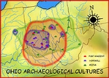
that flourished from 1000-1750 CE among a people who predominantly inhabited land along the Ohio River
Ohio River
The Ohio River is the largest tributary, by volume, of the Mississippi River. At the confluence, the Ohio is even bigger than the Mississippi and, thus, is hydrologically the main stream of the whole river system, including the Allegheny River further upstream...
in areas of modern-day Southern Ohio
Ohio
Ohio is a Midwestern state in the United States. The 34th largest state by area in the U.S.,it is the 7th‑most populous with over 11.5 million residents, containing several major American cities and seven metropolitan areas with populations of 500,000 or more.The state's capital is Columbus...
, Northern Kentucky
Kentucky
The Commonwealth of Kentucky is a state located in the East Central United States of America. As classified by the United States Census Bureau, Kentucky is a Southern state, more specifically in the East South Central region. Kentucky is one of four U.S. states constituted as a commonwealth...
, Southeastern Indiana
Indiana
Indiana is a US state, admitted to the United States as the 19th on December 11, 1816. It is located in the Midwestern United States and Great Lakes Region. With 6,483,802 residents, the state is ranked 15th in population and 16th in population density. Indiana is ranked 38th in land area and is...
and Western West Virginia
West Virginia
West Virginia is a state in the Appalachian and Southeastern regions of the United States, bordered by Virginia to the southeast, Kentucky to the southwest, Ohio to the northwest, Pennsylvania to the northeast and Maryland to the east...
. They were a maize based agricultural society who lived in sedentary villages and built ceremonial platform mounds. The Fort Ancient culture was once thought to have been an expansion of the Mississippian culture
Mississippian culture
The Mississippian culture was a mound-building Native American culture that flourished in what is now the Midwestern, Eastern, and Southeastern United States from approximately 800 CE to 1500 CE, varying regionally....
s. It is now accepted as an independently developed culture descended from the Hopewell culture
Hopewell culture
The Hopewell tradition is the term used to describe common aspects of the Native American culture that flourished along rivers in the northeastern and midwestern United States from 200 BCE to 500 CE. The Hopewell tradition was not a single culture or society, but a widely dispersed set of related...
(100 BCE–500 CE).
Name
The name of the culture originates from the Fort Ancient, OhioFort Ancient, Ohio
Fort Ancient is a collection of Native American earthworks located in Washington Township, Warren County, Ohio, along the eastern shore of the Little Miami River about seven miles southeast of Lebanon on State Route 350...
archeological site; however, the Fort Ancient Site itself is now thought to have been built by Ohio Hopewellian people. It was likely occupied later by the Fort Ancient culture. The fort is located on a hill above the Little Miami River
Little Miami River
The Little Miami River is a Class I tributary of the Ohio River that flows through five counties in southwestern Ohio in the United States. The Little Miami joins the Ohio River east of Cincinnati. It forms parts of the borders between Hamilton and Clermont counties and between Hamilton and Warren...
, close to Lebanon, Ohio
Lebanon, Ohio
The population at the 2010 census was 20,033. As of the census of 2000, there were 16,962 people residing in the city. The population density was 1,440.6 people per square mile . There were 6,218 housing units at an average density of 528.1 per square mile...
. Despite its name, most archaeologists do not believe that Fort Ancient was used primarily as a fortress by either the Ohio Hopewell culture or the Fort Ancient culture; it was more likely to have been a ceremonial location.
Archaeological record
Chronology
| Periods | Phase | Dates |
|---|---|---|
| Early Fort Ancient | Croghan | 1000 to 1200 |
| Middle Fort Ancient | Manion | 1200 to 1400 |
| Late Fort Ancient | Gist | 1400 to 1550 |
| Montour | 1550 to 1750 |
Starting in about 1000 CE terminal Late Woodland groups in the Middle Ohio Valley adopted maize
Maize
Maize known in many English-speaking countries as corn or mielie/mealie, is a grain domesticated by indigenous peoples in Mesoamerica in prehistoric times. The leafy stalk produces ears which contain seeds called kernels. Though technically a grain, maize kernels are used in cooking as a vegetable...
agriculture and began settling in small, year-round nuclear family households of no more than 40 to 50 individuals. These small scattered settlements, located along terraces that overlooked rivers and sometimes on flood plains, would be occupied for short periods before the groups moved on to new locations. By 1200 the small villages began to coalesce into larger settlements with up to 300 people and would be occupied for longer periods, possibly up to 25 years. During the Early and Middle Fort Ancient period, the houses were designed as single-family dwellings. Later Fort Ancient buildings are larger multi-family dwellings. Settlements were rarely permanent, usually being shifted to a new location after one or two generations when the resources surrounding the old village were exhausted. Villages were laid out with an open oval central plaza
Plaza
Plaza is a Spanish word related to "field" which describes an open urban public space, such as a city square. All through Spanish America, the plaza mayor of each center of administration held three closely related institutions: the cathedral, the cabildo or administrative center, which might be...
surrounded by circular and/or rectangular domestic structures facing into the plaza. The arrangement of buildings in Fort Ancient settlements is thought to have served as a sort of solar calendar, marking the positions of the solstices and other significant dates. Low platform mound
Platform mound
A platform mound is any earthwork or mound intended to support a structure or activity.-Eastern North America:The indigenous peoples of North America built substructure mounds for well over a thousand years starting in the Archaic period and continuing through the Woodland period...
s began to be constructed in some villages and many villages add defensive palisade
Palisade
A palisade is a steel or wooden fence or wall of variable height, usually used as a defensive structure.- Typical construction :Typical construction consisted of small or mid sized tree trunks aligned vertically, with no spacing in between. The trunks were sharpened or pointed at the top, and were...
s. The plaza was the center of village life and was a place where ceremonies, games (such as chunkey
Chunkey
Chunkey is a game of Native American origin. It was played by rolling disc shaped stones across the ground and throwing spears at them in an attempt to place the spear as close to the stopped stone as possible...
) and other social events were held.
The Late Fort Ancient period from 1400 to 1750 is the protohistoric era
Protohistory
Protohistory refers to a period between prehistory and history, during which a culture or civilization has not yet developed writing, but other cultures have already noted its existence in their own writings...
in the Middle Ohio Valley. This era saw a coalescencing of the formerly more dispersed populations, with Gist phase villages (1400 to 1550) becoming much larger than the preceding period with populations as high as 500 individuals. This factor and the increase in defensive palisades has led archaeologists to speculate that after 1450 warfare and intergroup strife increased, leading them to consolidate their villages for better protection. Villages appear to have been inhabited all year round during the Montour phase, although less densely in the winter than in the summer months. This may indicate that during the winter family groups and hunting parties may have returned to the regions previously occupied by their ancestors before the consolidations into larger villages. This is a pattern observed during historic times among the Miami and Potawatomi
Potawatomi
The Potawatomi are a Native American people of the upper Mississippi River region. They traditionally speak the Potawatomi language, a member of the Algonquian family. In the Potawatomi language, they generally call themselves Bodéwadmi, a name that means "keepers of the fire" and that was applied...
. This era also show increased contact with Mississippian peoples and may have included actual migration and integration of some culturally Mississippian peoples into Fort Ancient villages. The Madisonville horizon after 1400 includes relatively high proportions of bowls, salt pans, triangular strap handles, colanders, negative painted pottery
Angel Phase
The Angel Phase describes a 300-400-year cultural manifestation of the Mississippian culture of the central portions of the United States of America, as defined in the discipline of archaeology. Angel Phase archaeological sites date from c...
, notched and beaded rims, and some effigies, materials more usually associated with the Mississippian cultures of the Lower Ohio Valley such as Angel Mounds
Angel Mounds
Angel Mounds State Historic Site is located on the Ohio River in Vanderburgh and Warrick Counties eight miles southeast of Evansville and just upriver of the confluence of the Green and Ohio rivers. Administered by the Indiana Department of Natural Resources, Division of Indiana State Museums...
and Kincaid Mounds
Kincaid Mounds State Historic Site
The Kincaid Mounds Historic Site, circa 1050-1400 CE, was among the largest prehistoric Mississippian culture chiefdom centers, located at the southern tip of present day U.S. state of Illinois...
, which were abandoned during this time period. During the Montour phase (1550 to 1700) the introduction of European trade items such as glass, iron, brass, and copper as grave goods at sites such as Lower Shawneetown and Hardin Village
Hardin Village Site
The Hardin Village Site is a Fort Ancient culture Montour Phase archaeological site located on a terrace of the Ohio River near South Shore in Greenup County, Kentucky. It is located within the Big Sandy Management Area along with the nearby Lower Shawneetown site. The site was first inhabited...
precede the actual arrival of Europeans into the area. Although the Fort Ancient peoples didn't actually meet Europeans at this time, they, like other groups in the interior of the continent, may have felt the effects of their diseases. After this time period is a gap in the archaeological record and the next known inhabitants (encountered by French and English explorers) are the historic Shawnee
Shawnee
The Shawnee, Shaawanwaki, Shaawanooki and Shaawanowi lenaweeki, are an Algonquian-speaking people native to North America. Historically they inhabited the areas of Ohio, Virginia, West Virginia, Western Maryland, Kentucky, Indiana, and Pennsylvania...
tribe. Most likely their society, like the Mississippian cultures to the south and west, was severely disrupted by waves of epidemics from the very first Spanish explorers in the mid 16th century. After 1525 at the Madisonville Site, the type site
Type site
In archaeology a type site is a site that is considered the model of a particular archaeological culture...
for the Madisonville Phase, the village's house size becomes smaller and fewer with evidence to be a less horticulture-centered, sedentary way of life. However, it is generally accepted that similarities in material culture, art, mythology, and Shawnee oral history linking them to the Fort Ancients can be used to establish the shift of Fort Ancient society into historical Shawnee society.
Four Foci
Fort Ancient culture is divided into four distinct local variations known as foci (plural of focus). They are the Madisonville Focus, the Baum Focus, the Feurt Focus, and the Anderson Focus.Social hierarchy
The rise in socio-political complexity evidenced by the building of substructure mounds and new village layouts may indicate influences from Middle Mississippian cultureMississippian culture
The Mississippian culture was a mound-building Native American culture that flourished in what is now the Midwestern, Eastern, and Southeastern United States from approximately 800 CE to 1500 CE, varying regionally....
s down the Ohio River
Ohio River
The Ohio River is the largest tributary, by volume, of the Mississippi River. At the confluence, the Ohio is even bigger than the Mississippi and, thus, is hydrologically the main stream of the whole river system, including the Allegheny River further upstream...
(the northeastern most extent of Middle Mississippian was the Prather Complex in the Falls of the Ohio region 95 miles (152.9 km) away), but the differences in ceramics show they were a culture distinct from that of the Middle Mississippian peoples. Fort Ancient settlements lacked other Mississippian traits such as political centralization and elite social structures. Although individuals might have risen to the status of leader, the Fort Ancient culture appears to have been egalitarian. Grave goods rarely vary between individuals, which shows that social levels were weakly defined. It is thought that their societies were organized into groups (maybe tribes) based on kinship. If social organization was based on kinship, then it is likely that one's status was the result of personal qualities such as sharing/giving, being a good hunter or food provider, charisma, etc. Sometimes, one person might achieve high status. Such high-status people were probably leaders of communities and were potentially responsible for organizing trade, for settling disputes among other members of the village, and for presiding over ceremonies.
Ceramics
Fort Ancient peoples used a technique known as coiling to make their pottery, because as with all other Native American groups the potters wheel was unknown. They would first roll the clay into long, rounded strips and then use the strips to model the vessel, layering the strips one on top of another. The inside of the vessel was then smoothed out using a potters anvil ( a smooth round stone ) and the outside was smoothed using a wooden paddle. It could then be decorated in a variety of styles, including cord-marking and engraving. The pottery of this period has thinner walls than preceding Woodland pottery. Common shapes are large plain cooking jars with strap or loop handles. A hallmark of Fort Ancient pottery is engraved decorations on the rim and neck of the vessels, consisting of a series of interlocking lines, called guillochéGuilloché
Guilloché is a decorative engraving technique in which a very precise intricate repetitive pattern or design is mechanically engraved into an underlying material with fine detail...
. This design emerged with the beginning of the Fort Ancient culture in the region and is used as a diagnostic tool for identifying the culture.
Mississippian influences
During the Early Fort Ancient period grit (crushed stone) and grog (crushed pottery) were more often used as tempering agents, with ground musselMussel
The common name mussel is used for members of several families of clams or bivalvia mollusca, from saltwater and freshwater habitats. These groups have in common a shell whose outline is elongated and asymmetrical compared with other edible clams, which are often more or less rounded or oval.The...
shells occasionally being used. As time progressed however, mussel shells or a mixture of mussel shell with other agents becomes increasingly present as the tempering agent of choice. The use of ground shells as a temper is a feature often associated with Mississippian cultures. This new technology was not adopted wholesale however, as it was accepted in different Fort Ancient areas a different times and seems to become more prevalent in some villages as time goes by, moving north and east from the Ohio River and the direction of closest Mississippian groups in the southwest. With this change of temper also came different vessel forms and decorations, several of them also strongly associated with Mississippian cultures. Early Fort Ancient vessels are often jug forms often with lug handles. By the Middle Fort Ancient period bowls and plates are also being produced more frequently and the use of strap handles develops. Negative painting (a decoration often associated with the Angel Phase
Angel Phase
The Angel Phase describes a 300-400-year cultural manifestation of the Mississippian culture of the central portions of the United States of America, as defined in the discipline of archaeology. Angel Phase archaeological sites date from c...
sites in the Lower Ohio Valley) and Ramey Incised designs (elite motifs associated with the Cahokia
Cahokia
Cahokia Mounds State Historic Site is the area of an ancient indigenous city located in the American Bottom floodplain, between East Saint Louis and Collinsville in south-western Illinois, across the Mississippi River from St. Louis, Missouri. The site included 120 human-built earthwork mounds...
polity in Illinois) was found to have been used on some examples. A few examples have even had a blending of different styles, with the engraved guilloché decoration overlain by negative painting. Excavations have found examples of exotic non local pottery from this period as well. These articles are made from non local clay sources and show designs or vessel forms atypical for local wares. One example found at the Madisonville Site was a head pot similar to those produced in the Central Mississippi Valley by the peoples of the Middle Mississippian Parkin and Nodena Phase
Nodena Phase
The Nodena Phase is an archaeological phase in eastern Arkansas and southeastern Missouri of the Late Mississippian culture which dates from about 1400–1650 CE. The Nodena Phase is known from a collection of villages along the Mississippi River between the Missouri Bootheel and Wapanocca Lake...
s. Archaeologists have theorized that this change in pottery styles was a result of increased contact with the Mississippian cultures to the south and west of the Fort Ancient peoples.
Tools
Tools were made by the Fort Ancient peoples from a variety of materials including stone, bone, horn, shells and antlers, although stone tools more frequently show up in archaeological digs. They are particularly known for their small triangular flint arrowheads and large triangular flint knives. Hoes for farming were made from musselMussel
The common name mussel is used for members of several families of clams or bivalvia mollusca, from saltwater and freshwater habitats. These groups have in common a shell whose outline is elongated and asymmetrical compared with other edible clams, which are often more or less rounded or oval.The...
shells and axes for felling trees were made by grinding and polishing stones into the proper shape. Most of the flint tools were made from varieties of locally available materials, showing the Fort Ancient peoples either felt no need for or did not have access to exotic stone varieties through trade routes.
Diet
The Fort Ancient were primarily a farming and hunting people. Their diet was composed mainly of the New World staples known as the three sistersThree Sisters (agriculture)
The Three Sisters are the three main agricultural crops of various Native American groups in North America: squash, maize, and climbing beans ....
( maize
Maize
Maize known in many English-speaking countries as corn or mielie/mealie, is a grain domesticated by indigenous peoples in Mesoamerica in prehistoric times. The leafy stalk produces ears which contain seeds called kernels. Though technically a grain, maize kernels are used in cooking as a vegetable...
, squash
Squash (fruit)
Squashes generally refer to four species of the genus Cucurbita, also called marrows depending on variety or the nationality of the speaker...
, and beans ) supplemented with hunting and fishing in nearby forests and rivers. Important game species included the black bear, turkey
Turkey
Turkey , known officially as the Republic of Turkey , is a Eurasian country located in Western Asia and in East Thrace in Southeastern Europe...
, white tail deer and elk
Elk
The Elk is the large deer, also called Cervus canadensis or wapiti, of North America and eastern Asia.Elk may also refer to:Other antlered mammals:...
. Archaeologists have found evidence at some sites that suggest turkeys were even kept in pens. This heavy dependence on maize did have its drawbacks though. The average lifespan during this time period decreased from that of their ancestors. The people were also smaller in stature and less able to fend off infectious diseases. In archaeological investigations of their cemeteries it has been determined that almost all Fort Ancients peoples showed pathology of some kind, with high incidents of dental disease and arthritis.
Sites
| Site | Image | DescriptionCleek-McCabe Site |
|---|---|---|
| Buckner Site Buckner Site The Buckner Site is a Middle Fort Ancient culture archaeological site located in Bourbon County, Kentucky on Strodes Creek. It has two large circular village areas, each surrounding its own central plaza and several smaller special use areas to the north and northeast of the site. The site was... |
A Middle Fort Ancient site located in Bourbon County, Kentucky Bourbon County, Kentucky Bourbon County is a county located in the U.S. state of Kentucky. It is the remnant of what was previously a much larger Bourbon County, established as part of Virginia in 1785, and comprising what are now thirty-four modern Kentucky counties... on Strodes Creek. It has two large circular village areas, each surrounding its own central plaza and several smaller special use areas to the north and northeast of the site. |
|
| Buffalo Indian Village Site Buffalo Indian Village Site The Buffalo archeological site is located nearby Buffalo, Putnam County, West Virginia along the Kanawha River in the USA. The location is a multi-component site having Archaic village , one Middle Woodland village , and at least two overlapping Fort Ancient villages... |
A site with at least two overlapping Mid to Late Fort Ancient villages (1300 to 1600) located near Buffalo Buffalo, West Virginia Buffalo is a town in Putnam County, West Virginia, along the Kanawha River. The population was 1,236 at the 2010 census.-Geography:Buffalo is located at .According to the United States Census Bureau, the town has a total area of... , Putnam County, West Virginia Putnam County, West Virginia As of the census of 2000, there were 51,589 people, 20,028 households, and 15,281 families residing in the county. The population density was 149 people per square mile . There were 21,621 housing units at an average density of 62 per square mile... along the Kanawha River Kanawha River The Kanawha River is a tributary of the Ohio River, approximately 97 mi long, in the U.S. state of West Virginia. The largest inland waterway in West Virginia, it has formed a significant industrial region of the state since the middle of the 19th century.It is formed at the town of Gauley... . |
|
| Cleek-McCabe Site Cleek-McCabe Site The Cleek-McCabe Site is a Middle Fort Ancient culture archaeological site near Walton in Boone County, Kentucky, in the northern Bluegrass region of the state. It is situated on Mud Lick Creek approximately from the Ohio River... |
A Middle Fort Ancient site located near Walton Walton, Kentucky Walton is a city in Boone and Kenton Counties in the U.S. state of Kentucky. The population was 3,635 in the 2010 Census.-Tourism:Nearby Florence offers thoroughbred racing at Turfway Park.... in Boone County, Kentucky Boone County, Kentucky Boone County is a county located in the U.S. state of Kentucky. It was formed in 1798. The population was 118,811 in the 2010 Census. Its county seat is Burlington. The county is named for frontiersman Daniel Boone... with several components, including two mounds and a village. |
|
| Clover Site Clover Site The Clover Site is a Fort Ancient culture archeological site located near Lesage in Cabell County, West Virginia, United States. It is significant for its well-preserved remains of a late prehistoric/protohistoric Native American village. The sites unique assemblage has made it the type site for... |
A Late Fort Ancient Madisonville Focus site (the type site Type site In archaeology a type site is a site that is considered the model of a particular archaeological culture... for the Clover Phase 1550 to 1600) located near Lesage Lesage, West Virginia Lesage is an unincorporated census-designated place on Ohio River Road in Cabell County, West Virginia, United States. As of the 2010 census, its population was 1,358. It is the nearest community to Clover Site, a National Historic Landmark.... in Cabell County, West Virginia Cabell County, West Virginia As of the census of 2000, there were 96,784 people, 41,180 households, and 25,490 families residing in the county. The population density was 344 people per square mile . There were 45,615 housing units at an average density of 162 per square mile... . |
|
| Feurt Mounds and Village Site Feurt Mounds and Village Site The Feurt Mounds and Village Site is an Fort Ancient culture archaeological site with three burial mounds and an associated village, located in Clay Township in Scioto County, Ohio.-History:... |
A site with three burial mounds and an associated village, located in Scioto County, Ohio Scioto County, Ohio As of the census of 2000, there were 79,195 people, 30,871 households, and 21,362 families residing in the county. The population density was 129 people per square mile . There were 34,054 housing units at an average density of 56 per square mile... . It is the type site for the Feurt Focus. |
|
| Fort Ancient Site | 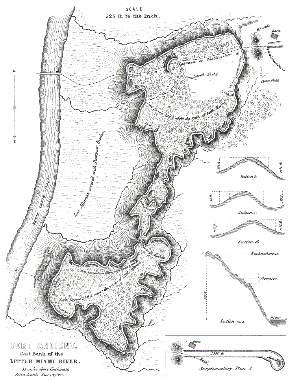 |
The site is the largest prehistoric hilltop enclosure in the United States with three and one-half miles (18,000 ft) of walls in a 100 acre (0.404686 km²) complex, built by the Hopewell peoples, who lived in the area from the 1st century BCE to the 6th century CE. Centuries later during the Fort Ancient period a village and cemetery were constructed within the embankments. When archaeologists excavated the site in the nineteenth century they mistakenly believed the "fort" and the village were built by the same people. It is located in Washington Township Washington Township, Warren County, Ohio Washington Township is one of the eleven townships of Warren County, Ohio, United States. Located in the east central part of the county, it is the only one of the eleven that does not contain a municipality... , Warren County, Ohio Warren County, Ohio Warren County is a county located in the state of Ohio, United States. The population was 212,693 at the 2010 census. Its county seat is Lebanon. Warren County was erected May 1, 1803, from Hamilton County, and named for Dr... , along the eastern shore of the Little Miami River Little Miami River The Little Miami River is a Class I tributary of the Ohio River that flows through five counties in southwestern Ohio in the United States. The Little Miami joins the Ohio River east of Cincinnati. It forms parts of the borders between Hamilton and Clermont counties and between Hamilton and Warren... about seven miles (11 km) southeast of Lebanon Lebanon, Ohio The population at the 2010 census was 20,033. As of the census of 2000, there were 16,962 people residing in the city. The population density was 1,440.6 people per square mile . There were 6,218 housing units at an average density of 528.1 per square mile... on State Route 350. |
| Fox Farm Site Fox Farm Site (Mays Lick, Kentucky) The Fox Farm Site is a Middle Fort Ancient culture Manion Phase archaeological site located near Mays Lick in Mason County, Kentucky. The site consists of a large village complex on a ridge south of the Licking River and south of the Ohio River. The site covers 10-16 hectacres and has midden... |
A Manion Phase site located near Mays Lick Mays Lick, Kentucky Mays Lick is an unincorporated community located in Mason County, Kentucky, United States, about nine miles southwest of Maysville.- History :... in Mason County, Kentucky Mason County, Kentucky Mason County is a county located in the U.S. state of Kentucky. As of 2000, the population was 16,800. Its county seat is Maysville. The county is named for George Mason, a Virginia delegate to the U.S. Constitutional Convention, known as the "Father of the Bill of Rights"... . The site consists of a large village complex on a ridge 2.5 kilometres (1.6 mi) south of the Licking River Licking River (Kentucky) The Licking River is a tributary of the Ohio River in northeastern Kentucky in the United States. The river and its tributaries drain much of the region of northeastern Kentucky between the watersheds of the Kentucky River to the west and the Big Sandy River to the east.-Origin of name:The Native... and 10 kilometres (6.2 mi) south of the Ohio River. The site covers 10 hectares (100,000 m²) to 16 hectares (160,000 m²) and has midden areas up to 80 centimetres (31.5 in) thick. |
|
| Hardin Village Site Hardin Village Site The Hardin Village Site is a Fort Ancient culture Montour Phase archaeological site located on a terrace of the Ohio River near South Shore in Greenup County, Kentucky. It is located within the Big Sandy Management Area along with the nearby Lower Shawneetown site. The site was first inhabited... |
A Montour Phase site located on a terrace of the Ohio River near South Shore South Shore, Kentucky As of the census of 2000, there were 1,226 people, 539 households, and 335 families residing in the city. The population density was 1,916.9 people per square mile . There were 605 housing units at an average density of 945.9 per square mile... in Greenup County, Kentucky Greenup County, Kentucky Greenup County is a county located in the U.S. state of Kentucky. It was formed in 1804. As of 2000, the population was 36,891. Its county seat is Greenup. The county is named in honor of Christopher Greenup.... . It was occupied from sometime in the early 1500s and abandoned by about 1625. During its occupation it covered an area of about 4.5 hectares (45,000 m²). Like other Fort Ancient villages it had a defensive palisade Palisade A palisade is a steel or wooden fence or wall of variable height, usually used as a defensive structure.- Typical construction :Typical construction consisted of small or mid sized tree trunks aligned vertically, with no spacing in between. The trunks were sharpened or pointed at the top, and were... surrounding it, but unlike other sites it does not seem to have had a central oval plaza Plaza Plaza is a Spanish word related to "field" which describes an open urban public space, such as a city square. All through Spanish America, the plaza mayor of each center of administration held three closely related institutions: the cathedral, the cabildo or administrative center, which might be... . |
|
| Hobson Site | Located 1.5 miles (2.4 km) below Middleport, Ohio Middleport, Ohio Middleport is a village in Meigs County, Ohio, United States, along the Ohio River. The population was 2,525 at the 2000 census.Middleport was the home of Walter "Mother" Watson, a Major League Baseball pitcher.-Geography:... on the north bank of the Ohio River. It has minor traces of Archaic, Woodland and Late Prehistoric artifacts. However, the largest component is a village of the Feurt Phase dating to 1100 to 1200 CE. |
|
| Leo Petroglyph Leo Petroglyph The Leo Petroglyph is a sandstone petroglyph containing 37 images of humans and animals as well as footprints of each. The petroglyph is located near the small village of Leo, Ohio and is thought to have been created by the Fort Ancient peoples... |
A sandstone Sandstone Sandstone is a sedimentary rock composed mainly of sand-sized minerals or rock grains.Most sandstone is composed of quartz and/or feldspar because these are the most common minerals in the Earth's crust. Like sand, sandstone may be any colour, but the most common colours are tan, brown, yellow,... petroglyph Petroglyph Petroglyphs are pictogram and logogram images created by removing part of a rock surface by incising, picking, carving, and abrading. Outside North America, scholars often use terms such as "carving", "engraving", or other descriptions of the technique to refer to such images... containing 37 images of humans and animals as well as footprints of each, located near the small village of Leo, Ohio in Jackson County, Ohio Jackson County, Ohio Jackson County is a county located in the state of Ohio, United States. As of 2010, the population was 33,225. Its county seat is Jackson and is named for Andrew Jackson, a hero of the War of 1812 who was subsequently elected President of the United States.... |
|
| Lower Shawneetown | Also known as the Bentley Site, Shannoah and Sonnontio, it is a Madisonville horizon (post 1400) archaeological site Archaeological site An archaeological site is a place in which evidence of past activity is preserved , and which has been, or may be, investigated using the discipline of archaeology and represents a part of the archaeological record.Beyond this, the definition and geographical extent of a 'site' can vary widely,... overlain by an 18th century Shawnee Shawnee The Shawnee, Shaawanwaki, Shaawanooki and Shaawanowi lenaweeki, are an Algonquian-speaking people native to North America. Historically they inhabited the areas of Ohio, Virginia, West Virginia, Western Maryland, Kentucky, Indiana, and Pennsylvania... village located near South Portsmouth in Greenup County, Kentucky. |
|
| Ronald Watson Gravel Site Ronald Watson Gravel Site The Ronald Watson Gravel Site is an archaeological site near Petersburg in Boone County, Kentucky, on an inside bend of a meander of the Ohio River... |
A Middle Fort Ancient Anderson Focus site located near Petersburg in Boone County, Kentucky Boone County, Kentucky Boone County is a county located in the U.S. state of Kentucky. It was formed in 1798. The population was 118,811 in the 2010 Census. Its county seat is Burlington. The county is named for frontiersman Daniel Boone... , on an inside bend of a meander Meander A meander in general is a bend in a sinuous watercourse. A meander is formed when the moving water in a stream erodes the outer banks and widens its valley. A stream of any volume may assume a meandering course, alternately eroding sediments from the outside of a bend and depositing them on the... of the Ohio River. |
|
| Sand Ridge Site | A Madisonville Focus site located along a prominent ridgeline to the west of the old Union Bridge along the road between Cincinnati and Batavia Batavia, Ohio Batavia is a village in and the county seat of Clermont County, Ohio, United States. The population was 1,617 at the 2000 census.-Geography:Batavia is located at .... . |
|
| Serpent Mound Serpent Mound The Great Serpent Mound is a -long, three-foot-high prehistoric effigy mound located on a plateau of the Serpent Mound crater along Ohio Brush Creek in Adams County, Ohio. Maintained within a park by the Ohio Historical Society, it has been designated a National Historic Landmark by the United... |
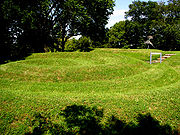 |
The Fort Ancient people built the largest effigy mound in the United States United States The United States of America is a federal constitutional republic comprising fifty states and a federal district... according to carbon dating of charcoal found underneath the mound. |
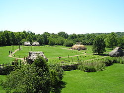
| SunWatch Indian Village SunWatch Indian Village SunWatch Indian Village / Archaeological Park is a recreated Fort Ancient Native American village that sits alongside the Great Miami River in Dayton, Ohio.... |
|
A recreated Fort Ancient village located in Dayton, Ohio Dayton, Ohio Dayton is the 6th largest city in the U.S. state of Ohio and the county seat of Montgomery County, the fifth most populous county in the state. The population was 141,527 at the 2010 census. The Dayton Metropolitan Statistical Area had a population of 841,502 in the 2010 census... . Many archaeological excavations were done here at the park which has revealed much about the Fort Ancient people. |
| State Line Site | A Middle Fort Ancient complex of sites west of Elizabethtown, Ohio on both sides of the Indiana/Ohio border, composed of five contributing properties spread out across 8 acres (32,374.9 m²) of land. Pottery found at the site was found to use shell tempering and had other characteristics such as distinctive styles of painting and the presence of pottery modelled after owls and the human heads, traits which signify contact with Middle Mississippian cultures. | |
| Thompson Site Thompson Site The Thompson Site is a Fort Ancient culture archaeological site located near South Portsmouth in Greenup County, Kentucky, next to the Ohio River across from the mouth of the Scioto River. It was occupied during the Croghan Phase of the local chronology and was a contemporary of Baum Phase sites in... |
A Croghan Phase site located near South Portsmouth, Kentucky in Greenup County, next to the Ohio River across from the mouth of the Scioto River Scioto River The Scioto River is a river in central and southern Ohio more than 231 miles in length. It rises in Auglaize County in west central Ohio, flows through Columbus, Ohio, where it collects its largest tributary, the Olentangy River, and meets the Ohio River at Portsmouth... . |
|
| Turpin Site | An Early Fort Ancient Madisonville Focus site located near Newtown Newtown, Ohio Newtown is a village in southeastern Hamilton County, Ohio, United States, near Cincinnati. The population was 2,420 at the 2000 census.Newtown was first settled in 1792 under the name of Mercersburg. The name was changed before the village incorporated in 1901.-History:Multiple Native American... in Hamilton County, Ohio Hamilton County, Ohio As of 2000, there were 845,303 people, 346,790 households, and 212,582 families residing in the county. The population density was 2,075 people per square mile . There were 373,393 housing units at an average density of 917 per square mile... . The site includes the remains of a village and multiple burial mounds. |
|
Contemporaries and neighbors
The people of the Fort Ancient regions were surrounded by other groups, some similar in their lifestyles and some not. To their northeast in present-day Western PennsylvaniaWestern Pennsylvania
Western Pennsylvania consists of the western third of the state of Pennsylvania in the United States. Pittsburgh is the largest city in the region, with a metropolitan area population of about 2.4 million people, and serves as its economic and cultural center. Erie, Altoona, and Johnstown are its...
, Eastern Ohio and West Virginia were the peoples of the Monongahela culture, who inhabited the Monongahela River
Monongahela River
The Monongahela River is a river on the Allegheny Plateau in north-central West Virginia and southwestern Pennsylvania in the United States...
Valley from 1050 to 1635. They had a similar lifestyle to the Fort Ancients; they were also maize agriculturalists and lived in well laid out palisaded villages with central oval plazas, some of which consisted of as many as 50-100 structures. To the northwest of the Fort Ancients were the people of the Oliver Phase
Oliver Phase
The Oliver Phase is the name for a Late Woodland Native American culture that flourished from 1200 and 1450 CE along the east and west forks of the White River in central and southern Indiana. The Oliver Phase is of the Western Basin Tradition which includes the Springwells Phase, the Younge Phase,...
who lived along the east and west forks of the White River
White River (Indiana)
The White River is a two-forked river that flows through central and southern Indiana and is the main tributary to the Wabash River. Via the west fork, considered to be the main stem of the river by the U.S. Board on Geographic Names, the White River is long.-West Fork:The West Fork, long, is...
in central and southern Indiana
Indiana
Indiana is a US state, admitted to the United States as the 19th on December 11, 1816. It is located in the Midwestern United States and Great Lakes Region. With 6,483,802 residents, the state is ranked 15th in population and 16th in population density. Indiana is ranked 38th in land area and is...
from 1200 and 1450. Their villages were also circular with palisade
Palisade
A palisade is a steel or wooden fence or wall of variable height, usually used as a defensive structure.- Typical construction :Typical construction consisted of small or mid sized tree trunks aligned vertically, with no spacing in between. The trunks were sharpened or pointed at the top, and were...
s. Although their sites began in central Indiana, over the years they spread to the southeast toward the Fort Ancients. The Oliver Phase people were part of the Western Basin Tradition which also includes the Springwells Phase, the Younge Phase, and the Riviere au Vase Phases of Northern Ohio and Indiana. The colder weather of the Little Ice Age
Little Ice Age
The Little Ice Age was a period of cooling that occurred after the Medieval Warm Period . While not a true ice age, the term was introduced into the scientific literature by François E. Matthes in 1939...
may have caused inter-group battling over food and other resources, according to some scholars. The crops did not prosper as well during this colder period, causing food shortages for populations that had grown after their introduction. Some studies show that the culture began failing due to poor health conditions.
These groups, along with others such as the Oneota
Oneota
Oneota is a designation archaeologists use to refer to a cultural complex that existed in the eastern plains and Great Lakes area of what is now the United States from around AD 900 to around 1650 or 1700. The culture is believed to have transitioned into various Macro-Siouan cultures of the...
, were once classified as Upper Mississippian culture
Upper Mississippian culture
Upper Mississippian culture, sometimes referred to as Upper Mississippian cultures , is the archaeological designation for certain late prehistoric cultures of the indigenous peoples of eastern North America, located in the present day Midwestern United States region.Included are:*the Oneota...
s under the assumption that they were either Mississippian peoples intruding into these areas or they were heavily influenced by the Mississippian peoples to their south and east. Today it is thought that these groups were local in situ developments of Late Woodland peoples.