

Eyre Peninsula
Encyclopedia
Peninsula
A peninsula is a piece of land that is bordered by water on three sides but connected to mainland. In many Germanic and Celtic languages and also in Baltic, Slavic and Hungarian, peninsulas are called "half-islands"....
in South Australia
South Australia
South Australia is a state of Australia in the southern central part of the country. It covers some of the most arid parts of the continent; with a total land area of , it is the fourth largest of Australia's six states and two territories.South Australia shares borders with all of the mainland...
. It is bounded on the east by Spencer Gulf
Spencer Gulf
The Spencer Gulf is the westernmost of two large inlets on the southern coast of Australia, in the state of South Australia, facing the Great Australian Bight. The Gulf is 322 km long and 129 km wide at its mouth. The western shore of the Gulf is the Eyre Peninsula, while the eastern side is the...
, the west by the Great Australian Bight
Great Australian Bight
The Great Australian Bight is a large bight, or open bay, off the central and western portions of the southern coastline of mainland Australia.-Extent:...
, and the north by the Gawler Ranges
Gawler Ranges
The Gawler Ranges are a range of stoney hills in South Australia to the north of Eyre Peninsula. The Eyre Highway skirts the south of the ranges. The Gawler Ranges National Park and Gawler Ranges Conservation Reserve are in the ranges north of Wudinna...
. It is named after explorer Edward John Eyre
Edward John Eyre
Edward John Eyre was an English land explorer of the Australian continent, colonial administrator, and a controversial Governor of Jamaica....
who explored some of it in 1839-1841. The coastline was first explored by Matthew Flinders
Matthew Flinders
Captain Matthew Flinders RN was one of the most successful navigators and cartographers of his age. In a career that spanned just over twenty years, he sailed with Captain William Bligh, circumnavigated Australia and encouraged the use of that name for the continent, which had previously been...
in 1801-1802. The west coast was also visited by Nicolas Baudin
Nicolas Baudin
Nicolas-Thomas Baudin was a French explorer, cartographer, naturalist and hydrographer.Baudin was born a commoner in Saint-Martin-de-Ré on the Île de Ré. At the age of fifteen he joined the merchant navy, and at twenty joined the French East India Company...
at around the same time.
Overview
The peninsula was explored by a party led by John Charles DarkeJohn Charles Darke
John Charles Darke, 1806–1844, was a surveyor and explorer in Van Diemen's Land and South Australia. He died after being speared by aborigines in 1844.-Early years:...
in 1844, who was killed by local aborigines on the return to Port Lincoln.
The main towns are Port Lincoln
Port Lincoln, South Australia
- Transport :Port Lincoln is the port for the isolated narrow gauge Eyre Peninsular Railway.There is also a subsidiary port at Proper Bay which may be restored to use for iron ore traffic. The export of iron ore through Port Lincoln has been approved by the South Australian Government. Port...
on the southern point, Whyalla
Whyalla, South Australia
-Demographics:According to the 2006 Census the population of the Whyalla census area was 21,122 people, making it the second largest urban area in the state outside of Adelaide...
and Port Augusta
Port Augusta, South Australia
-Electricity generation:Electricity is generated at the Playford B and Northern power stations from brown coal mined at Leigh Creek, 250 km to the north...
at the north east, and Ceduna
Ceduna, South Australia
Ceduna is a small town in the West Coast region of South Australia. It is situated in the northwest corner of Eyre Peninsula, facing the islands of the Nuyts Archipelago. It lies west of the junction of the Flinders and Eyre Highways around 786 km northwest of the capital Adelaide. The port...
at the northwest. They are connected by the Eyre Highway
Eyre Highway
The Eyre Highway is a highway linking Western Australia and South Australia via the Nullarbor Plain. Signed as National Highway 1/A1, it forms part of Highway 1 and the Australian National Highway network linking Perth and Adelaide. It was named after explorer Edward John Eyre, who was the first to...
across the inland edge, and the Flinders Highway
Flinders Highway, South Australia
Flinders Highway connects the South Australian towns of Ceduna and Port Lincoln, a distance of 410 kilometres. The highway was formerly designated as National Route Alternate 1 and currently signed as B100...
and Lincoln Highway
Lincoln Highway (Australia)
Lincoln Highway links Port Augusta and Port Lincoln, both located in South Australia, a distance of 327 kilometres. It was formerly designated as National Route Alternate 1 and is currently B100....
along the west and east coasts.
The major industry is farming - cereal crops, sheep, and cattle
Cattle
Cattle are the most common type of large domesticated ungulates. They are a prominent modern member of the subfamily Bovinae, are the most widespread species of the genus Bos, and are most commonly classified collectively as Bos primigenius...
in the drier north and more water-intensive activities such as dairy farming
Dairy farming
Dairy farming is a class of agricultural, or an animal husbandry, enterprise, for long-term production of milk, usually from dairy cows but also from goats and sheep, which may be either processed on-site or transported to a dairy factory for processing and eventual retail sale.Most dairy farms...
and a growing wine
Wine
Wine is an alcoholic beverage, made of fermented fruit juice, usually from grapes. The natural chemical balance of grapes lets them ferment without the addition of sugars, acids, enzymes, or other nutrients. Grape wine is produced by fermenting crushed grapes using various types of yeast. Yeast...
industry in the south. Many coastal towns have commercial fishing, in particular Port Lincoln, had a large tuna
Tuna
Tuna is a salt water fish from the family Scombridae, mostly in the genus Thunnus. Tuna are fast swimmers, and some species are capable of speeds of . Unlike most fish, which have white flesh, the muscle tissue of tuna ranges from pink to dark red. The red coloration derives from myoglobin, an...
-fishing fleet, which is gradually being converted to fish farming
Fish farming
Fish farming is the principal form of aquaculture, while other methods may fall under mariculture. Fish farming involves raising fish commercially in tanks or enclosures, usually for food. A facility that releases young fish into the wild for recreational fishing or to supplement a species'...
in bays along the coast. The Eyre Peninsula has a growing population of around 55,390 people.
There is a commercial nephrite
Nephrite
Nephrite is a variety of the calcium and magnesium-rich amphibole mineral actinolite . The chemical formula for nephrite is Ca25Si8O222. It is one of two different mineral species called jade. The other mineral species known as jade is jadeite, which is a variety of pyroxene...
jade
Jade
Jade is an ornamental stone.The term jade is applied to two different metamorphic rocks that are made up of different silicate minerals:...
mine near Cowell
Cowell, South Australia
Cowell is a coastal town on Franklin Harbour on the eastern side of the Eyre Peninsula, in South Australia on the Lincoln Highway 111 km south from the major town of Whyalla...
. Iron ore is mined in the hills near Iron Knob inland from Whyalla, to where it is transported by rail for smelting
Smelting
Smelting is a form of extractive metallurgy; its main use is to produce a metal from its ore. This includes iron extraction from iron ore, and copper extraction and other base metals from their ores...
.
National Parks located on the Eyre peninsula include Lincoln National Park
Lincoln National Park
Lincoln is a national park in South Australia , 249 km west of Adelaide. It occupies the Jussieu Peninsula and a number of nearby islands....
, Coffin Bay National Park
Coffin Bay National Park
Coffin Bay is a national park in on the Eyre Peninsula of South Australia , 301 km west of Adelaide, and 46 km west of Port Lincoln. The township of Coffin Bay is near the entrance to the National Park...
, Gawler Ranges National Park
Gawler Ranges National Park
Gawler Ranges is a 1633 km2 national park lying 350 km north-west of Adelaide in the northern Eyre Peninsula of South Australia. It is known for its spectacular rock formations.-History:...
, and several conservation parks and reserves like Acraman Creek Conservation Park
Acraman Creek Conservation Park
Acraman Creek Conservation Park is located on the northern side of Streaky Bay on the western side of the Eyre Peninsula in South Australia, about half way between Ceduna and Streaky Bay townships....
.
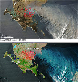
In January 2005, the Eyre Peninsula was the site of bushfires
Eyre Peninsula bushfire
In January 2005, Eyre Peninsula, South Australia, was the scene of a devastating bushfire in which nine people were killed and at least 113 injured. It was one of Australia’s worst bushfires since the Ash Wednesday fires of 1983....
killing 9 people.
Transport
The peninsular is served by the isolated narrow gaugeNarrow gauge
A narrow gauge railway is a railway that has a track gauge narrower than the of standard gauge railways. Most existing narrow gauge railways have gauges of between and .- Overview :...
Eyre Peninsula Railway
Eyre Peninsula Railway
The Eyre Peninsula Railway is a railway on the Eyre Peninsula of South Australia. The system is isolated from the rest of the South Australian railway network.- Overview :The network consists of about 600km of route and carries mainly wheat and gypsum...
. This line is separated from the main system by desert country, and hence there has never been any need for a connecting link.
Physiography
The area is also known as the Eyre Coastal Plain, is part of the Eyre Yorke BlockEyre Yorke Block
The Eyre Yorke Block is an Interim Biogeographic Regionalisation for Australia region and a World Wildlife Fund ecoregion covering the Eyre and Yorke Peninsulas around the Spencer Gulf on the coast of South Australia. -Location and description:...
bioregion
Interim Biogeographic Regionalisation for Australia
The Interim Biogeographic Regionalisation for Australia is a biogeographic regionalisation of Australia developed by the Australian Government's Department of the Environment, Water, Heritage and the Arts...
, and is a distinct physiographic section of the larger Eucla Basin
Eucla Basin
The Eucla Basin is an artesian depression located in Western Australia and South Australia. The onshore-offshore depression covers approximately 1,141,000 km² and slopes southward to an open bay known as the Great Australian Bight. It extends more than 500 km offshore and about 350 km inland from...
province, which in turn is part of the larger West Australian Shield
Australian Shield
The Australian Shield, also called the Western Australian Shield or Western Plateau, occupies more than half of the continent of Australia. It occupies the portion of Australia west of a line running north-south roughly from the eastern shore of Arnhem Land on the Bay or Gulf of Carpentaria to the...
division.