Ceduna, South Australia
Encyclopedia
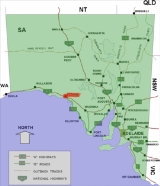
Ceduna is a small town in the West Coast region of South Australia
. It is situated in the northwest corner of Eyre Peninsula
, facing the islands of the Nuyts Archipelago
. It lies west of the junction of the Flinders
and Eyre Highway
s around 786 km northwest of the capital Adelaide
. The port town/suburb of Thevenard
lies 3 km to the west on Cape Thevenard. It is in the District Council of Ceduna
, the federal Division of Grey
, and the state electoral district of Flinders
. The name Ceduna is a corruption of the local Aboriginal word Chedoona and is said to mean a place to sit down and rest. The town has played an important but minor role in Australia's overall development due to it being a fishing port and a railroad hub.
 There was a whaling
station on nearby St Peter Island during the 1850s.
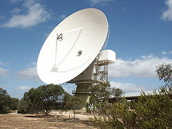
Ceduna was the site of a major satellite telecommunications facility operated by the Overseas Telecommunications Commission
. It was a major employer in the town until made redundant by technological change.
On 4 December 2002, Ceduna received international attention when the path of totality of a solar eclipse
passed directly over the town. Though the day had at times been partly cloudy, the southwestern sky where the Sun and Moon were located was clear at the time of the total solar eclipse, late in the afternoon.
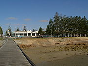
from east to west. It is set on Murat Bay and the sandy coves, sheltered bays and offshore islands of the bay make it a popular base for a beach holiday. The foreshore at Ceduna is lined with Norfolk Island pine
trees. There is a jetty for walking, fishing and small boats.
Ceduna has a number of Indigenous homelands situated within 20–30 minutes of the town. These are groupings of Indigenous families who have chosen to live together. The council area has the highest percentage of Aboriginal people of all local government areas in South Australia, with the population currently standing at 24.1% (860) of the population. A number of Aboriginal communities in adjacent unincorporated areas rely on the available services in Ceduna and use the town as a base for a variety of reasons.
is developing a new mine at Jacinth- Ambrosia which will rely on Ceduna as a service town.
A major residential development called Ceduna Waters is being developed by Carramatta Holdings, a significant South Australian property developer, which was responsible for the Talbot Grove affordable housing development.
Prospectively, the development is projected to result in the growth of the population of Ceduna by over 10%. The development will allow for the provision of additional residential accommodation in Ceduna to meet the needs of workers at the Iluka
Jacinth- Ambrosia mine.
 Ceduna has a radio telescope
that is being integrated into the CSIRO radio telescope network. It is also a hub for research on Southern Ocean Tuna.
with hot, dry summers and cool, wet winters July is the wettest month. The average yearly precipitation is just under 300mm at the coast and diminishes northward into the interior, becoming increasingly semi-arid. Goyder's Line
, which demarcates the edge of the area where rainfall is generally sufficient to support agriculture, starts near Ceduna.
South Australia
South Australia is a state of Australia in the southern central part of the country. It covers some of the most arid parts of the continent; with a total land area of , it is the fourth largest of Australia's six states and two territories.South Australia shares borders with all of the mainland...
. It is situated in the northwest corner of Eyre Peninsula
Eyre Peninsula
Eyre Peninsula is a triangular peninsula in South Australia. It is bounded on the east by Spencer Gulf, the west by the Great Australian Bight, and the north by the Gawler Ranges. It is named after explorer Edward John Eyre who explored some of it in 1839-1841. The coastline was first explored by...
, facing the islands of the Nuyts Archipelago
Nuyts Archipelago
The Nuyts Archipelago, including the Isles of St Francis, comprises a group of mainly small and mostly granitic islands lying off Ceduna, South Australia, at the eastern end of the Great Australian Bight and the north-western coast of the Eyre Peninsula...
. It lies west of the junction of the Flinders
Flinders Highway, South Australia
Flinders Highway connects the South Australian towns of Ceduna and Port Lincoln, a distance of 410 kilometres. The highway was formerly designated as National Route Alternate 1 and currently signed as B100...
and Eyre Highway
Eyre Highway
The Eyre Highway is a highway linking Western Australia and South Australia via the Nullarbor Plain. Signed as National Highway 1/A1, it forms part of Highway 1 and the Australian National Highway network linking Perth and Adelaide. It was named after explorer Edward John Eyre, who was the first to...
s around 786 km northwest of the capital Adelaide
Adelaide
Adelaide is the capital city of South Australia and the fifth-largest city in Australia. Adelaide has an estimated population of more than 1.2 million...
. The port town/suburb of Thevenard
Thevenard, South Australia
Thevenard is a port town 3 km east of Ceduna, South Australia. It is named after nearby Cape Thevenard, which in turn had been named after Antoine-Jean-Marie Thévenard, a French admiral. At the 2006 census, Thevenard had a population of 776.The port at Thevenard, handles bulk grain, gypsum...
lies 3 km to the west on Cape Thevenard. It is in the District Council of Ceduna
District Council of Ceduna
The District Council of Ceduna is a Local Government Area located on the far west coast of the Eyre Peninsula in South Australia. The district has a diverse business and industry with an estimated 240,000 tourists passing through every year....
, the federal Division of Grey
Division of Grey
The Division of Grey is an Australian Electoral Division in South Australia.The division was created in 1903 and is named for Sir George Grey, who was Governor of South Australia 1841-45 ....
, and the state electoral district of Flinders
Electoral district of Flinders
Flinders is an electoral district of the House of Assembly in the Australian state of South Australia. It is named after explorer Matthew Flinders, who was responsible for charting most of the state's coastline. It is a 55,260.6 km² coastal rural electorate encompassing the Eyre Peninsula and...
. The name Ceduna is a corruption of the local Aboriginal word Chedoona and is said to mean a place to sit down and rest. The town has played an important but minor role in Australia's overall development due to it being a fishing port and a railroad hub.
History

Whaling
Whaling is the hunting of whales mainly for meat and oil. Its earliest forms date to at least 3000 BC. Various coastal communities have long histories of sustenance whaling and harvesting beached whales...
station on nearby St Peter Island during the 1850s.
Ceduna was the site of a major satellite telecommunications facility operated by the Overseas Telecommunications Commission
Overseas Telecommunications Commission
The Overseas Telecommunications Commission was established by an Act of Parliament in August 1946. It inherited facilities and resources from Amalgamated Wireless Australasia Limited and Cable & Wireless, and was charged with responsibility for all international telecommunications services into,...
. It was a major employer in the town until made redundant by technological change.
On 4 December 2002, Ceduna received international attention when the path of totality of a solar eclipse
Solar eclipse
As seen from the Earth, a solar eclipse occurs when the Moon passes between the Sun and the Earth, and the Moon fully or partially blocks the Sun as viewed from a location on Earth. This can happen only during a new moon, when the Sun and the Moon are in conjunction as seen from Earth. At least...
passed directly over the town. Though the day had at times been partly cloudy, the southwestern sky where the Sun and Moon were located was clear at the time of the total solar eclipse, late in the afternoon.
Description
With a population of 2,304, the town is the last major settlement before crossing the Nullarbor PlainNullarbor Plain
The Nullarbor Plain is part of the area of flat, almost treeless, arid or semi-arid country of southern Australia, located on the Great Australian Bight coast with the Great Victoria Desert to its north. It is the world's largest single piece of limestone, and occupies an area of about...
from east to west. It is set on Murat Bay and the sandy coves, sheltered bays and offshore islands of the bay make it a popular base for a beach holiday. The foreshore at Ceduna is lined with Norfolk Island pine
Araucaria heterophylla
Araucaria heterophylla is a distinctive conifer, a member of the ancient and now disjointly distributed family Araucariaceae. As its vernacular name Norfolk Island Pine implies, the tree is endemic to Norfolk Island, a small island in the Pacific Ocean between Australia, New Zealand and New...
trees. There is a jetty for walking, fishing and small boats.
Demographics
Ceduna urban area had a population of 2,304 in the 2006 census. The wider Ceduna council area recorded a population of 3,574 in the 2006 census.Ceduna has a number of Indigenous homelands situated within 20–30 minutes of the town. These are groupings of Indigenous families who have chosen to live together. The council area has the highest percentage of Aboriginal people of all local government areas in South Australia, with the population currently standing at 24.1% (860) of the population. A number of Aboriginal communities in adjacent unincorporated areas rely on the available services in Ceduna and use the town as a base for a variety of reasons.
Education
The two schools in Ceduna are Crossways Lutheran School and Ceduna Area School (CAS). Crossways has around 150 students from Reception to Year 10, of which approximately 80% are Indigenous. CAS has approximately 600 students, from Reception to Year 12, with approximately 25% of Indigenous students.Economic activity
Iluka ResourcesIluka Resources
Iluka Resources is a mining company involved in the mining and processing of titanium based and zircon products. The company mines heavy mineral sands and separates the concentrate into its individual mineral constituents rutile, ilmenite, leucoxene and zircon...
is developing a new mine at Jacinth- Ambrosia which will rely on Ceduna as a service town.
A major residential development called Ceduna Waters is being developed by Carramatta Holdings, a significant South Australian property developer, which was responsible for the Talbot Grove affordable housing development.
Prospectively, the development is projected to result in the growth of the population of Ceduna by over 10%. The development will allow for the provision of additional residential accommodation in Ceduna to meet the needs of workers at the Iluka
Iluka
Iluka may refer to* Iluka, New South Wales - a town on the north coast of New South Wales in Australia* Iluka, Western Australia - a suburb of Perth* Iluka Resources - an Australian mining company...
Jacinth- Ambrosia mine.
Scientific research

Radio telescope
A radio telescope is a form of directional radio antenna used in radio astronomy. The same types of antennas are also used in tracking and collecting data from satellites and space probes...
that is being integrated into the CSIRO radio telescope network. It is also a hub for research on Southern Ocean Tuna.
Cultural festivals
Ceduna's annual Oysterfest is a major attraction on the October long weekend. It was established in 1991. It celebrates the oyster industry in the clean waters of SA's far-west coast, with a wide variety of activities, including a gala dinner, a charity quest, live concerts, children's amusements and a street parade. The finale is marked by a fireworks display.Climate
Ceduna has a Mediterranean climateMediterranean climate
A Mediterranean climate is the climate typical of most of the lands in the Mediterranean Basin, and is a particular variety of subtropical climate...
with hot, dry summers and cool, wet winters July is the wettest month. The average yearly precipitation is just under 300mm at the coast and diminishes northward into the interior, becoming increasingly semi-arid. Goyder's Line
Goyder's Line
Goyder's Line is a boundary line across South Australia corresponding to a rainfall boundary believed to indicate the edge of the area suitable for agriculture. North of Goyder's Line, the rainfall is not reliable enough, and the land is only suitable for grazing and not cropping. The line traces a...
, which demarcates the edge of the area where rainfall is generally sufficient to support agriculture, starts near Ceduna.
Individuals from Ceduna
- Chris SperouChris SperouChris Sperou is an Australian aerobatic pilot. Sperou has won the Australian Aerobatic Championship 13 times, and has flown in 5 World Aerobatic Championships.-Biography:...
, aerobatic pilot, born in Ceduna in 1938 - Jodi MartinJodi MartinJodi Miranda Martin is an Australian singer-songwriter living in Sydney. Her professional music career began in mid-1996 while she was still a student, when she was the opening act for Arlo Guthrie's first Australian tour...
, singer/songwriter, born and raised in Ceduna - Jenny Borlase (née Kennett), former netballer, was born in Ceduna
- Krista Eleftheriou, journalist and former television presenter, raised in Ceduna
- Greg Irvine, thoroughbred journalist, born and raised in Ceduna and first published in the Ceduna based West Coast Sentinel as a 14-year-old

