
Erdington
Encyclopedia
Erdington is a suburb 5 miles (8 km) northeast of Birmingham
city centre, England
and bordering Sutton Coldfield
. It is also a council constituency, managed by its own district committee. The formal council constituency the smaller ward of Erdington, and the wards of Tyburn
(formerly Kingsbury), Stockland Green
and Kingstanding
, although most of both Kingstanding and Tyburn wards and some of Stockland Green lie outside the historical boundaries of Erdington.
, Erdington Hall, which was protected on three sides by a double moat on the fourth by the River Tame. It had developed from a small fortified homestead constructed by an Anglo-Saxon named Eardwulf
in the area of Bromford
. Demolished in the 17th century, it stood on a hill at the junction of what is now Wheelwright Road and Tyburn Road. The double moat was drained in the 18th century by Sir Charles Holte. Up until 1912 stood another building which was demolished for the construction of the Tyburn Road, though a small section did remain until World War I
.
Other moated properties included one at Fern Road, one at the junction of Moor End Lane and Berkswell Road, and another that surrounded a large farm called Pipe Orchard, the site of which can be seen in the Erdington Grammar School playing fields.
in the 9th century. The settlers also established communities in what is now Minworth
and Curdworth. It is also believed that the Roman track 'Ridgeway', now Chester Road, also provided a source of people looking to settle. Evidence to support this comes from the early nucleus of the village which was located a very short distance from the path.
The Earls of Mercia had possession of the village at the time of the Norman conquest. At this time, Edwin, grandson of Lady Godiva
, owned the property and he resisted all attempts by the Normans to gain possession of Erdington. However, he failed and as a result was executed in 1071. The earldom was then passed to William I
who placed the manor and village in the possession of William Fitz-Ansculf
, a powerful baron of Norman heritage who lived at Dudley Castle
. He then gave the manor to a man named Peter de Erdington.
Erdington was mentioned in the Domesday Book
under the name Hardintone and was under the possession of Peter. It had arable land for six ploughs, a mill and 5 acres (20,234.3 m²) of meadows and woodland. It was valued at 30 shillings and was one mile (1.6 km) in length and half a mile in breadth.
As a result of Erdington's close proximity to Sutton Coldfield and more precisely, Sutton Forest, strict Norman laws were placed upon the village forbidding the hunting of wild animals and the keeping of sheep, as a result of Norman beliefs. However, tenants were permitted an allowance of timber from the forest, though, with limitations to protect royal game. Erdington remained within the precincts of Sutton Forest until 1126, when Henry I
exchanged the Manor of Sutton, with forest, for two manors in Rutland
belonging to Roger, Earl of Warwick
. The forest became a chase and the laws placed on the woodland were relaxed.
The mill mentioned in the Domesday Book was located in Bromford, where it stood close to the manor house at a loop in the river, at which a straight channel was cut to facilitate the milling of corn. The mill was owned by the lord of the manor and the tenants were obliged to grind their corn there. Erdington was connected to Bromford via Bromford Lane, which still exists today in the midst of a 1960s council estate.
In the 15th century, a chapel was constructed on the side of the manor house for the residents of Erdington. However, attendance was low and the chapel fell into decay. The residents were then urged to travel to the parish church in Aston, however, again the attendance was low. A south aisle was therefore added to the church and became known as the Erdington chantry.
The Black Death
plague affected Erdington severely as indicated by the 14th century local records. Henry de Pipe, owner of the Manor of Pipe (now Pype Hayes Hall
), suffered the loss of all but one child and his wife. Henry married another woman, Maud, who was the daughter of George de Castello of Castle Bromwich. However, after soon discovering that she was pregnant with a child conceived with another man, he died.
. Salford Bridge was first mentioned as Shrafford Brugge during the reign of Henry III
. It was originally a footbridge
, however, in 1810, it was improved for the crossing of vehicles. The word Shrafford was of Saxon origin meaning "the ford by the caves". These caves were cavities in the nearby Copeley escarpment
. The caves were artificially enlarged and survived World War II
. During the war, they were converted into air raid shelters. After the war they were completely destroyed for the construction of the Gravelly Hill Interchange
.
During the 16th and 17th centuries, new families resided at Erdington Hall. The Dymock's moved in and were a prominent family, with several members being knights. However, their strict rule which consisted of unpopular manorial laws made them unpopular amongst the residents of Erdington.
erupted, Erdington was expanding rapidly through the purchase of land for agricultural purposes. In 1643, Birmingham was plundered by the Royalists
. After his victory in Birmingham, Prince Rupert passed through Erdington and Sutton Coldfield with his troops on their way to Lichfield
.
act was passed for the Chester Road and another act was passed in 1807 for a road that passed through Erdington village from Birmingham. This resulted in Erdington being a stop-off location for stage coaches which passed along the Chester Road to Chester
from London
. In 1783, the Birmingham-Fazeley Canal was completed. It passed along the southern boundary of Erdington at Tyburn. Planning requests included that the canal should not pass within 500 metres of Pype Hayes Hall
.
By the mid-1700s, Erdington had a population of under 700 and within its boundaries were 52 roads, one forge, 40 farms, 96 cottages, two smithies and a shop. By 1832, it had a population of 2,000.
Erdington broke from Aston in 1894 to become an urban district
. Administrative offices were established at the Rookery on Kingsbury Road, which have since become Rookery Park. In 1911, the urban district council of Erdington and that of Aston Manor were absorbed into the growing city of Birmingham.
Erdington shopping centre formed the core of the area with most of the older housing being located close to it. The railway alongside also attracted the development of many Victorian
and Edwardian houses.
institution, then a Psychiatric hospital
. There was a social stigma
to being treated there. Other large psychiatric institutions in Birmingham have been broken up. All of the old Highcroft Hospital grounds have been used for new housing. The main hospital itself has been renovated into luxury apartments and has been named Highcroft Hall. Highcroft Hall was built between 1869 and 1871 by Victorian
architect
Yeoville Thomason
.
The building, sanctioned by the Poor Law Board
, was originally a workhouse providing housing to paupers, idiots, tramps, seniles, lunatics and imbeciles (terms used at the time with distinctive definitions).
The building was originally named the Aston Union Workhouse although it has been renamed over the years to Erdington House (1912 - following the City boundary changes), Highcroft Hall Hospital (1942) and was more commonly referred to in later years as just Highcroft Hospital.
Over the years, the hospital has generally provided care for the mentally ill. In 1994, the hospital became part of the Northern Birmingham Mental Health NHS Trust. During the following two years, the facilities were gradually rehoused in more modern units nearby and in 1996, the building was declared closed.
The site was derelict for the subsequent eight years, before being refurbished by property developers between 2004 and 2006.
frame, a sweeping staircase and a false upper storey to hide the laundry facilities on the roof.
The Lyndhurst estate is now the focus of a redevelopment scheme in Erdington. The low rise maisonettes will be demolished as well as Harlech and Burcombe Towers. Modern residential properties will be built on the site and the money raised from this will be used to refurbish the remaining tower blocks.
in Anglo Saxon times
, with 'ton' or 'tun' being an Anglo-Saxon suffix for a settlement of that period. This homestead developed into a large house in the area of Bromford
and became Erdington Hall.
However the name "Yenton" also applies to the possible corruption of "Yerdington", an enclosure, which could apply to a moated homestead.
, situated on the southern edge of the district and on the border of Aston
and Gravelly Hill
. As well as being a road interchange, two railway lines, three canals, and two rivers also converge on that location. It has also been a historic crossing point in Birmingham, with the incorporation of Salford Bridge
, which was first mentioned in a deed in 1490, although a bridge is believed to have been at this location since 1290.
, former home of Dunlop Rubber
, a relic of Erdington's industrial past. At its peak, it employed 10,000 people but its industrial usage has declined since with Dunlop maintaining only a small presence in the area. The main building was redeveloped from 2005 to 2006 into office and retail space by Urban Splash
. The area surrounding Fort Dunlop is used by logistics companies and also features showrooms operated by several car manufacturers, including Birmingham's only Lamborghini
dealership.
in 1996.
 Erdington has a distinct concentration of retail space, known as Erdington town centre or Erdington village, the main focus of which is Erdington High Street. There is also a market
located on Barnabas Road and another market, Wilton Market, between Sutton New Road and the High Street, next to Witton Market is Swannies which is intermediate between a market and a shopping centre. Opposite Witon Market and Swannies on the High Street is as Cooperative Store
which has been there since at least the 1950's and is the largest Supermarket
in the town centre. Erdington town centre is now a Business Improvement District
.
, and nearby on Sutton Road is The Abbey Church
. The Parish Church was severely damaged by fire on the morning of 4 October 2007. Also nearby, on Mason Road, is Erdington Swimming Baths which were constructed by the Birmingham Baths Committee
, this is a complex including Sauna
s and a fitness centre as well as a swimming pool
, Erdington Library, Opened in 1907 as a Carnegie library
, is a public library operated by Birmingham City Council
. It is the meeting place of the Erdington Historical Society on the second Monday of every month.
, was formerly a further education
college by the name of Josiah Mason College that merged with Sutton Coldfield College in 2006.
To the north of Erdington, within the area of Pype Hayes
on the border with Walmley
, is Pype Hayes Park
and Pype Hayes Hall
, the former home of the Bagot family
. A smaller park in the area is Sorrel Park.
The Old Green Man on Bromford Lane (now known as the Lad in the Lane
) is one of the oldest public house
s in Birmingham.
in neighbouring Sutton Coldfield
. Erdington is also served by the John Taylor Hospice and by Northcroft Hospital built on the edge of the site of the former Highcroft Hospital.
, Perry Barr
and Hodge Hill
, and the affluent and spacious districts of Sutton Coldfield
, Minworth
, Castle Bromwich
and Water Orton
(North Warwickshire
). It is located approximately five miles north east of Birmingham City Centre.
The borders of Erdington are:
Erdington also includes Pype Hayes
. This was formerly a working class
area of Council house
s built between World War I
and World War II
. These houses had to be demolished due to problems with the concrete used in their construction. Pype Hayes is now an area with modern houses, some are owner occupied
, others belong to Housing association
s. One tower block, Sorrel House, was retained and refurbished.
Brookvale Park Lake
and surrounding land is a park that was formally a drinking water reservoir until the steadily encroaching city made the water unfit for human consumption. It was briefly converted into an outdoor pool until that was also abandoned after health and safety concerns.
there were 22,626 Yentonians, as residents of Erdington are traditionally known. The term, "Yentonian" is hardly known or used in 21st century Erdington. The area where Chester Road crosses Birmingham Road and Sutton Road is called "The Yenton". The area had a population density of 50.7 people per hectare and the ward covers an area of 446.2 hectares. Erdington had a slightly higher proportion of females, at 52%, to males. This followed the city trend as 51.6% of the population of Birmingham are females. 98.6% of the population of Erdington lived in households whilst the remaining 1.4% lived in communal establishments. This is 0.3% above and 0.3% below the city average, respectively. There were a total of 10,547 households in Erdington, producing an average of 2.2 persons per household. This is below the city average of 2.5 and national average of 2.4. 63.4% of the households are owner occupied, above the city average of 60.4%. The local authority rented out 19.2% of the population. 5.8% of the households were rented from housing association
s and 8% were rented privately. 459 of households were vacant, which accounted for 4.4% of the total number of houses in Erdington. The most common housing type was semi-detached properties, whilst purpose built blocks of flats were the second most common.
The age patterns of Erdington are very similar to that of the England. 29.7% of the residents were in the 25-44 age bracket, above the city average of 28.3% and the nationwide average of 29.3%. 19% of residents were of a pensionable age, above the city average of 16.7%. 60% of the population were of a working age (16–65 years of age), above the city average of 59.8% but below the national average of 61.5%.
Erdington is a relatively little ethnically diversity for a suburb of a major English city. Some 8.9% of the population were born outside of the country, below the city average of 16.5% and national average of 9.3%. 89% of the population are white, well above the city average of 70.4% and just below the national average of 90.9%. Black ethnic groups were the second largest in Erdington, representing 3.9% of the population. 3.8% were from Asian ethnic groups and 2.8% were from mixed ethnic backgrounds. The remaining 0.5% were from Chinese and other ethnic groups. More specifically, the British White ethnic group represented 81.7% of the population and the Irish White represented 6%. 3.2% of the population were of Black Caribbean descent and 1.8% were of Indian descent.
71.% of the population of Erdington stated themselves as Christians
, the same figure for the rest of the country although higher than the Birmingham average of 59.1%. 14.9% of the population stated that they were of no religion. Muslims
represented only 2.2% of the population, below the Birmingham average of 14.3% and the lowest number in the city (together with the Sutton Coldfield wards).
Erdington had an unemployment rate of 8.1%, below the city rate of 9.5% but above the national average of 5%. 65.5% of the population were economically active. Of the economically inactive, 36.2% were retired and 10.7% were students. 33% were long term unemployed and 9.9% had never worked. Of the economically active, 17.5% worked in the Manufacturing sector. The largest employers in the area were the Education Department of Birmingham City Council
, Colliers Peugeot
dealers and Cincinnati Machine (UK) Ltd. all of which employed 200 people between them.
Erdington's best known resident was Josiah Mason
, the philanthropist
whose bust now stands at the centre of the roundabout
at the junction of Chester Road
and Orphanage Road
, so named because he founded an Orphanage there in 1860.
 There are three railway stations on the Cross-City Line serving Erdington; Erdington railway station
, Chester Road station
, and Gravelly Hill station
.
Important roads that access the area include A38 (Birmingham to Derby road)
, A5127 (Gravelly Hill)
and the A47 Spine Road
. The M6 motorway
forms the southern border of the district with connections at Junction 6 (Gravelly Hill Interchange
). There is a well established network of bus routes through Erdington with connections to Birmingham city centre and Sutton Coldfield, the majority of which are operated by National Express West Midlands
.
In the southern area of the district is the Birmingham Fazeley Canal which helped develop that area as a major employment sector. The River Tame added to this and with the introduction of the Birmingham and Derby Junction Railway
, the area became a prominent industrial area.
. There was much surprise when Conservative
Robert Alden won a seat in Erdington ward de-seating the Labour candidate Susannah McCory in 2006. Again in 2007, McCory lost to the Conservatives, this time to Gareth Compton who replaced the retiring long serving Labour councillor Renee Spector. The other seat in the ward was won, again by the Conservatives, by Bob Beuchamp, an Erdington garage owner.
Birmingham Erdington is a constituency
, its Member of Parliament
is Jack Dromey
. In addition to Erdington, the constituency includes the wards of Kingstanding
, Stockland Green
and Tyburn
all outside the traditional Erdington boundaries.
Erdington has adopted a Ward Support Officer with the current holder of the title being Alison Nicholls.
venue, Mothers
(previously the Carlton Ballroom), which from 1968 until it closed in 1971 played host to bands such as Pink Floyd
, Led Zeppelin
and The Who
. The resident band were Erdington locals The Moody Blues
and the DJ was John Peel
. The club was located opposite St Barnabus Church on the High Street above a furniture store. Local Erdington artists included The Moody Blues
.
Erdington boasts two cricket
teams in its Ward; Highcroft and Great Barr Unity (formed in 2003 following the merge of Highcroft Cricket Club and Great Barr Cricket Club) and Erdington Court. It also has a Gaelic football team, Erin Go Bragh.
Birmingham
Birmingham is a city and metropolitan borough in the West Midlands of England. It is the most populous British city outside the capital London, with a population of 1,036,900 , and lies at the heart of the West Midlands conurbation, the second most populous urban area in the United Kingdom with a...
city centre, England
England
England is a country that is part of the United Kingdom. It shares land borders with Scotland to the north and Wales to the west; the Irish Sea is to the north west, the Celtic Sea to the south west, with the North Sea to the east and the English Channel to the south separating it from continental...
and bordering Sutton Coldfield
Sutton Coldfield
Sutton Coldfield is a suburb of Birmingham, in the West Midlands of England. Sutton is located about from central Birmingham but has borders with Erdington and Kingstanding. Sutton is in the northeast of Birmingham, with a population of 105,000 recorded in the 2001 census...
. It is also a council constituency, managed by its own district committee. The formal council constituency the smaller ward of Erdington, and the wards of Tyburn
Tyburn, West Midlands
Tyburn is a ward in Birmingham, England formerly known as Kingsbury.It is part of the Erdington formal district and comprises Castle Vale, and the south-eastern part of Erdington. The significant landmarks in the area include Jaguar Cars' Castle Bromwich Assembly factory and Fort Dunlop.The newly...
(formerly Kingsbury), Stockland Green
Stockland Green
Stockland Green is an area of Birmingham, England.It gives its name to a ward which is part of the Erdington formal district, and which comprises the south-western part of Erdington including areas such as Stockland Green itself and Gravelly Hill....
and Kingstanding
Kingstanding
Kingstanding is an area in north Birmingham, England. It gives its name to a ward in the Erdington council constituency. Kingstanding ward includes the areas; Perry Common, St. Mary's College, Witton Lakes and parts of Kingstanding, Wyrley Birch and New Oscott...
, although most of both Kingstanding and Tyburn wards and some of Stockland Green lie outside the historical boundaries of Erdington.
Erdington Manor
Erdington had its own manor houseManor house
A manor house is a country house that historically formed the administrative centre of a manor, the lowest unit of territorial organisation in the feudal system in Europe. The term is applied to country houses that belonged to the gentry and other grand stately homes...
, Erdington Hall, which was protected on three sides by a double moat on the fourth by the River Tame. It had developed from a small fortified homestead constructed by an Anglo-Saxon named Eardwulf
Eardwulf
Eardwulf or Eardulf is an Anglo-Saxon male name. It may refer to:* Eardwulf of Northumbria, , ruler of Northumbria* Eardwulf of Kent , ruler of Kent...
in the area of Bromford
Bromford
Bromford is an industrial area of Birmingham, situated between Ward End and Erdington.- Toponomy :In Old English, "Bromford" means "broom ford", signifying abundance of broom shrubs and a location to cross the River Tame....
. Demolished in the 17th century, it stood on a hill at the junction of what is now Wheelwright Road and Tyburn Road. The double moat was drained in the 18th century by Sir Charles Holte. Up until 1912 stood another building which was demolished for the construction of the Tyburn Road, though a small section did remain until World War I
World War I
World War I , which was predominantly called the World War or the Great War from its occurrence until 1939, and the First World War or World War I thereafter, was a major war centred in Europe that began on 28 July 1914 and lasted until 11 November 1918...
.
Other moated properties included one at Fern Road, one at the junction of Moor End Lane and Berkswell Road, and another that surrounded a large farm called Pipe Orchard, the site of which can be seen in the Erdington Grammar School playing fields.
Middle Ages
Erdington developed as a village as a result of settlers travelling up the course of the River Tame from TamworthTamworth
Tamworth is a town and local government district in Staffordshire, England, located north-east of Birmingham city centre and north-west of London. The town takes its name from the River Tame, which flows through the town, as does the River Anker...
in the 9th century. The settlers also established communities in what is now Minworth
Minworth
Minworth is a village on the outskirts of Birmingham in the West Midlands area of England. It is located near Walmley, Wishaw, Warwickshire, Curdworth, Thimble End and Castle Vale....
and Curdworth. It is also believed that the Roman track 'Ridgeway', now Chester Road, also provided a source of people looking to settle. Evidence to support this comes from the early nucleus of the village which was located a very short distance from the path.
The Earls of Mercia had possession of the village at the time of the Norman conquest. At this time, Edwin, grandson of Lady Godiva
Lady Godiva
Godiva , often referred to as Lady Godiva , was an Anglo-Saxon noblewoman who, according to legend, rode naked through the streets of Coventry in order to gain a remission of the oppressive taxation imposed by her husband on his tenants...
, owned the property and he resisted all attempts by the Normans to gain possession of Erdington. However, he failed and as a result was executed in 1071. The earldom was then passed to William I
William I of England
William I , also known as William the Conqueror , was the first Norman King of England from Christmas 1066 until his death. He was also Duke of Normandy from 3 July 1035 until his death, under the name William II...
who placed the manor and village in the possession of William Fitz-Ansculf
William Fitz-Ansculf
William Fitz-Ansculf was a Norman-French landowner who suceeded his father, Ansculf de Picquigny.-Birth and early life:William's date of birth is not known, though it was likely in Picquigny, Somme, France in the mid 11th Century...
, a powerful baron of Norman heritage who lived at Dudley Castle
Dudley Castle
Dudley Castle is a ruined castle in the town of Dudley, West Midlands, England. Dudley Zoo is located in its grounds. The location, Castle Hill, is an outcrop of Wenlock Group limestone that was extensively quarried during the Industrial Revolution, and which now along with Wren's Nest Hill is a...
. He then gave the manor to a man named Peter de Erdington.
Erdington was mentioned in the Domesday Book
Domesday Book
Domesday Book , now held at The National Archives, Kew, Richmond upon Thames in South West London, is the record of the great survey of much of England and parts of Wales completed in 1086...
under the name Hardintone and was under the possession of Peter. It had arable land for six ploughs, a mill and 5 acres (20,234.3 m²) of meadows and woodland. It was valued at 30 shillings and was one mile (1.6 km) in length and half a mile in breadth.
As a result of Erdington's close proximity to Sutton Coldfield and more precisely, Sutton Forest, strict Norman laws were placed upon the village forbidding the hunting of wild animals and the keeping of sheep, as a result of Norman beliefs. However, tenants were permitted an allowance of timber from the forest, though, with limitations to protect royal game. Erdington remained within the precincts of Sutton Forest until 1126, when Henry I
Henry I of England
Henry I was the fourth son of William I of England. He succeeded his elder brother William II as King of England in 1100 and defeated his eldest brother, Robert Curthose, to become Duke of Normandy in 1106...
exchanged the Manor of Sutton, with forest, for two manors in Rutland
Rutland
Rutland is a landlocked county in central England, bounded on the west and north by Leicestershire, northeast by Lincolnshire and southeast by Peterborough and Northamptonshire....
belonging to Roger, Earl of Warwick
Earl of Warwick
Earl of Warwick is a title that has been created four times in British history and is one of the most prestigious titles in the peerages of the British Isles.-1088 creation:...
. The forest became a chase and the laws placed on the woodland were relaxed.
The mill mentioned in the Domesday Book was located in Bromford, where it stood close to the manor house at a loop in the river, at which a straight channel was cut to facilitate the milling of corn. The mill was owned by the lord of the manor and the tenants were obliged to grind their corn there. Erdington was connected to Bromford via Bromford Lane, which still exists today in the midst of a 1960s council estate.
In the 15th century, a chapel was constructed on the side of the manor house for the residents of Erdington. However, attendance was low and the chapel fell into decay. The residents were then urged to travel to the parish church in Aston, however, again the attendance was low. A south aisle was therefore added to the church and became known as the Erdington chantry.
The Black Death
Black Death
The Black Death was one of the most devastating pandemics in human history, peaking in Europe between 1348 and 1350. Of several competing theories, the dominant explanation for the Black Death is the plague theory, which attributes the outbreak to the bacterium Yersinia pestis. Thought to have...
plague affected Erdington severely as indicated by the 14th century local records. Henry de Pipe, owner of the Manor of Pipe (now Pype Hayes Hall
Pype Hayes Hall
Pype Hayes Hall is a former mansion house in the Pype Hayes area of Erdington, Birmingham, West Midlands. The hall is in Pype Hayes Park by by the gardens. It was formerly in the historic county of Warwickshire before being transferred into the new county of the West Midlands along with the rest...
), suffered the loss of all but one child and his wife. Henry married another woman, Maud, who was the daughter of George de Castello of Castle Bromwich. However, after soon discovering that she was pregnant with a child conceived with another man, he died.
Tudor period
It was around the 1500s in which the area of Gravelly Hill began to become mentioned in documents. John Leland described the area as being "by sandy ground, better wooded than fertile of wheat... the soil is sandy and good for conyes." This indicates that the area had a big population of rabbits (conyes) and it is known that it remained as a rabbit warren for a while as it was deemed unsuitable for cultivation. At the foot of Gravelly Hill was the River Tame which was spanned by Salford BridgeSalford Junction
Salford Junction is the name of the canal junction where the Grand Union Canal and Tame Valley Canal meet the Birmingham and Fazeley Canal north of Birmingham, England....
. Salford Bridge was first mentioned as Shrafford Brugge during the reign of Henry III
Henry III of England
Henry III was the son and successor of John as King of England, reigning for 56 years from 1216 until his death. His contemporaries knew him as Henry of Winchester. He was the first child king in England since the reign of Æthelred the Unready...
. It was originally a footbridge
Footbridge
A footbridge or pedestrian bridge is a bridge designed for pedestrians and in some cases cyclists, animal traffic and horse riders, rather than vehicular traffic. Footbridges complement the landscape and can be used decoratively to visually link two distinct areas or to signal a transaction...
, however, in 1810, it was improved for the crossing of vehicles. The word Shrafford was of Saxon origin meaning "the ford by the caves". These caves were cavities in the nearby Copeley escarpment
Escarpment
An escarpment is a steep slope or long cliff that occurs from erosion or faulting and separates two relatively level areas of differing elevations.-Description and variants:...
. The caves were artificially enlarged and survived World War II
World War II
World War II, or the Second World War , was a global conflict lasting from 1939 to 1945, involving most of the world's nations—including all of the great powers—eventually forming two opposing military alliances: the Allies and the Axis...
. During the war, they were converted into air raid shelters. After the war they were completely destroyed for the construction of the Gravelly Hill Interchange
Gravelly Hill Interchange
Gravelly Hill Interchange, better known by its nickname Spaghetti Junction, is junction 6 of the M6 motorway where it meets the A38 Aston Expressway in Birmingham, England.- Overview :...
.
During the 16th and 17th centuries, new families resided at Erdington Hall. The Dymock's moved in and were a prominent family, with several members being knights. However, their strict rule which consisted of unpopular manorial laws made them unpopular amongst the residents of Erdington.
English Civil War
As the English Civil WarEnglish Civil War
The English Civil War was a series of armed conflicts and political machinations between Parliamentarians and Royalists...
erupted, Erdington was expanding rapidly through the purchase of land for agricultural purposes. In 1643, Birmingham was plundered by the Royalists
Cavalier
Cavalier was the name used by Parliamentarians for a Royalist supporter of King Charles I and son Charles II during the English Civil War, the Interregnum, and the Restoration...
. After his victory in Birmingham, Prince Rupert passed through Erdington and Sutton Coldfield with his troops on their way to Lichfield
Lichfield
Lichfield is a cathedral city, civil parish and district in Staffordshire, England. One of eight civil parishes with city status in England, Lichfield is situated roughly north of Birmingham...
.
18th and 19th centuries
In 1759, a turnpikeTurnpike trust
Turnpike trusts in the United Kingdom were bodies set up by individual Acts of Parliament, with powers to collect road tolls for maintaining the principal highways in Britain from the 17th but especially during the 18th and 19th centuries...
act was passed for the Chester Road and another act was passed in 1807 for a road that passed through Erdington village from Birmingham. This resulted in Erdington being a stop-off location for stage coaches which passed along the Chester Road to Chester
Chester
Chester is a city in Cheshire, England. Lying on the River Dee, close to the border with Wales, it is home to 77,040 inhabitants, and is the largest and most populous settlement of the wider unitary authority area of Cheshire West and Chester, which had a population of 328,100 according to the...
from London
London
London is the capital city of :England and the :United Kingdom, the largest metropolitan area in the United Kingdom, and the largest urban zone in the European Union by most measures. Located on the River Thames, London has been a major settlement for two millennia, its history going back to its...
. In 1783, the Birmingham-Fazeley Canal was completed. It passed along the southern boundary of Erdington at Tyburn. Planning requests included that the canal should not pass within 500 metres of Pype Hayes Hall
Pype Hayes Hall
Pype Hayes Hall is a former mansion house in the Pype Hayes area of Erdington, Birmingham, West Midlands. The hall is in Pype Hayes Park by by the gardens. It was formerly in the historic county of Warwickshire before being transferred into the new county of the West Midlands along with the rest...
.
By the mid-1700s, Erdington had a population of under 700 and within its boundaries were 52 roads, one forge, 40 farms, 96 cottages, two smithies and a shop. By 1832, it had a population of 2,000.
Erdington broke from Aston in 1894 to become an urban district
Urban district
In the England, Wales and Ireland, an urban district was a type of local government district that covered an urbanised area. Urban districts had an elected Urban District Council , which shared local government responsibilities with a county council....
. Administrative offices were established at the Rookery on Kingsbury Road, which have since become Rookery Park. In 1911, the urban district council of Erdington and that of Aston Manor were absorbed into the growing city of Birmingham.
Erdington shopping centre formed the core of the area with most of the older housing being located close to it. The railway alongside also attracted the development of many Victorian
Victorian architecture
The term Victorian architecture refers collectively to several architectural styles employed predominantly during the middle and late 19th century. The period that it indicates may slightly overlap the actual reign, 20 June 1837 – 22 January 1901, of Queen Victoria. This represents the British and...
and Edwardian houses.
Highcroft Hospital
Highcroft Hospital was a former Poor LawPoor Law
The English Poor Laws were a system of poor relief which existed in England and Wales that developed out of late-medieval and Tudor-era laws before being codified in 1587–98...
institution, then a Psychiatric hospital
Psychiatric hospital
Psychiatric hospitals, also known as mental hospitals, are hospitals specializing in the treatment of serious mental disorders. Psychiatric hospitals vary widely in their size and grading. Some hospitals may specialise only in short-term or outpatient therapy for low-risk patients...
. There was a social stigma
Social stigma
Social stigma is the severe disapproval of or discontent with a person on the grounds of characteristics that distinguish them from other members of a society.Almost all stigma is based on a person differing from social or cultural norms...
to being treated there. Other large psychiatric institutions in Birmingham have been broken up. All of the old Highcroft Hospital grounds have been used for new housing. The main hospital itself has been renovated into luxury apartments and has been named Highcroft Hall. Highcroft Hall was built between 1869 and 1871 by Victorian
Victorian era
The Victorian era of British history was the period of Queen Victoria's reign from 20 June 1837 until her death on 22 January 1901. It was a long period of peace, prosperity, refined sensibilities and national self-confidence...
architect
Architect
An architect is a person trained in the planning, design and oversight of the construction of buildings. To practice architecture means to offer or render services in connection with the design and construction of a building, or group of buildings and the space within the site surrounding the...
Yeoville Thomason
Yeoville Thomason
H. R. Yeoville Thomason was an architect in Birmingham, England. He was born in Edinburgh to a Birmingham family. Thomason set up his own practice in Birmingham 1853-1854....
.
The building, sanctioned by the Poor Law Board
Poor Law Board
The Poor Law Board was established in the United Kingdom in 1847 as a successor body to the Poor Law Commission overseeing the administration of the 1834 Poor Law Amendment Act...
, was originally a workhouse providing housing to paupers, idiots, tramps, seniles, lunatics and imbeciles (terms used at the time with distinctive definitions).
The building was originally named the Aston Union Workhouse although it has been renamed over the years to Erdington House (1912 - following the City boundary changes), Highcroft Hall Hospital (1942) and was more commonly referred to in later years as just Highcroft Hospital.
Over the years, the hospital has generally provided care for the mentally ill. In 1994, the hospital became part of the Northern Birmingham Mental Health NHS Trust. During the following two years, the facilities were gradually rehoused in more modern units nearby and in 1996, the building was declared closed.
The site was derelict for the subsequent eight years, before being refurbished by property developers between 2004 and 2006.
Lyndhurst estate
On the Sutton Road, numbers 44-108 were demolished in 1957 for the construction of the Lyndhurst Estate. Number 44 was retained as it was an old building considered to be of interest. The demolished houses were detached post 1840 Victorian villas. Constructed on the site was six tower block#United KingdomTower blocks and numerous low rise maisonettes. The tallest of these, Harlech Tower, was 16 storeys and at the time it was the tallest tower block in Birmingham, though many taller blocks were later built. In 1961, the estate won the Civic Award for Housing for the retention of the original trees from the villas and the architectural qualities of the tower blocks which included an exposed concreteConcrete
Concrete is a composite construction material, composed of cement and other cementitious materials such as fly ash and slag cement, aggregate , water and chemical admixtures.The word concrete comes from the Latin word...
frame, a sweeping staircase and a false upper storey to hide the laundry facilities on the roof.
The Lyndhurst estate is now the focus of a redevelopment scheme in Erdington. The low rise maisonettes will be demolished as well as Harlech and Burcombe Towers. Modern residential properties will be built on the site and the money raised from this will be used to refurbish the remaining tower blocks.
Etymology
Though referred to as Hardintone in the Domesday Book, it is widely accepted that the name comes from a reference to a fortified homestead established by EardwulfEardwulf
Eardwulf or Eardulf is an Anglo-Saxon male name. It may refer to:* Eardwulf of Northumbria, , ruler of Northumbria* Eardwulf of Kent , ruler of Kent...
in Anglo Saxon times
Anglo-Saxons
Anglo-Saxon is a term used by historians to designate the Germanic tribes who invaded and settled the south and east of Great Britain beginning in the early 5th century AD, and the period from their creation of the English nation to the Norman conquest. The Anglo-Saxon Era denotes the period of...
, with 'ton' or 'tun' being an Anglo-Saxon suffix for a settlement of that period. This homestead developed into a large house in the area of Bromford
Bromford
Bromford is an industrial area of Birmingham, situated between Ward End and Erdington.- Toponomy :In Old English, "Bromford" means "broom ford", signifying abundance of broom shrubs and a location to cross the River Tame....
and became Erdington Hall.
However the name "Yenton" also applies to the possible corruption of "Yerdington", an enclosure, which could apply to a moated homestead.
Features
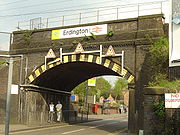
Erdington's history is documented well through its buildings. One of the most well-known features in the area is Spaghetti JunctionGravelly Hill Interchange
Gravelly Hill Interchange, better known by its nickname Spaghetti Junction, is junction 6 of the M6 motorway where it meets the A38 Aston Expressway in Birmingham, England.- Overview :...
, situated on the southern edge of the district and on the border of Aston
Aston
Aston is an area of the City of Birmingham, in the West Midlands of England. Lying to the north-east of the Birmingham city centre, Aston constitutes an electoral ward within the council constituency of Ladywood.-History:...
and Gravelly Hill
Gravelly Hill
Gravelly Hill is an area of Birmingham, England.- Notability :It is best known for its motorway junction, the Gravelly Hill Interchange, popularly known as Spaghetti Junction, which provides the intersection between the A38 Aston Expressway from the centre of Birmingham to the M6 motorway. The...
. As well as being a road interchange, two railway lines, three canals, and two rivers also converge on that location. It has also been a historic crossing point in Birmingham, with the incorporation of Salford Bridge
Salford Junction
Salford Junction is the name of the canal junction where the Grand Union Canal and Tame Valley Canal meet the Birmingham and Fazeley Canal north of Birmingham, England....
, which was first mentioned in a deed in 1490, although a bridge is believed to have been at this location since 1290.
Fort Dunlop
Nearby is Fort DunlopFort Dunlop
Fort Dunlop , is the common name of the original tyre factory and main office of Dunlop Rubber in the Erdington district of Birmingham, England. It was established in 1917, and by 1954 the entire factory area employed 10,000 workers...
, former home of Dunlop Rubber
Dunlop Rubber
Dunlop Rubber was a company based in the United Kingdom which manufactured tyres and other rubber products for most of the 20th century. It was acquired by BTR plc in 1985. Since then, ownership of the Dunlop trade-names has been fragmented.-Early history:...
, a relic of Erdington's industrial past. At its peak, it employed 10,000 people but its industrial usage has declined since with Dunlop maintaining only a small presence in the area. The main building was redeveloped from 2005 to 2006 into office and retail space by Urban Splash
Urban Splash
Urban Splash is a British company which regenerates decaying industrial warehouses, mills, Victorian terraced houses and other buildings. These buildings have mainly been converted into housing...
. The area surrounding Fort Dunlop is used by logistics companies and also features showrooms operated by several car manufacturers, including Birmingham's only Lamborghini
Lamborghini
Automobili Lamborghini S.p.A., commonly referred to as Lamborghini , is an Italian car manufacturer. The company was founded by manufacturing magnate Ferruccio Lamborghini in 1963, with the objective of producing a refined grand touring car to compete with established offerings from marques like...
dealership.
Shopping
Fort Dunlop lends its name to the nearby The Fort Shopping Park, constructed on reclaimed land by the Birmingham Heartlands Development CorporationBirmingham Heartlands Development Corporation
The Birmingham Heartlands Development Corporation was established in 1992 to develop 9.5 square kilometres of land in the East of Birmingham.-Pre-designation:...
in 1996.
Market
A market is one of many varieties of systems, institutions, procedures, social relations and infrastructures whereby parties engage in exchange. While parties may exchange goods and services by barter, most markets rely on sellers offering their goods or services in exchange for money from buyers...
located on Barnabas Road and another market, Wilton Market, between Sutton New Road and the High Street, next to Witton Market is Swannies which is intermediate between a market and a shopping centre. Opposite Witon Market and Swannies on the High Street is as Cooperative Store
The Co-operative Group
The Co-operative Group Ltd. is a United Kingdom consumer cooperative with a diverse range of business interests. It is co-operatively run and owned by its members. It is the largest organisation of this type in the world, with over 5.5 million members, who all have a say in how the business is...
which has been there since at least the 1950's and is the largest Supermarket
Supermarket
A supermarket, a form of grocery store, is a self-service store offering a wide variety of food and household merchandise, organized into departments...
in the town centre. Erdington town centre is now a Business Improvement District
Business improvement district
A business improvement district is a defined area within which businesses pay an additional tax or fee in order to fund improvements within the district's boundaries. Grant funds acquired by the city for special programs and/or incentives such as tax abatements can be made available to assist...
.
Other features in central Erdington
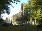
Also on the High Street is Erdington Parish ChurchSt. Barnabas' Church, Erdington
St. Barnabas' Church is the parish church of Erdington, in the north of Birmingham, England.-Background:It is located on the High Street, in the main shopping centre area of Erdington, and is a Grade II listed building. The vicar is the Reverend Freda Evans, inducted on June 19, 2008.-History:The...
, and nearby on Sutton Road is The Abbey Church
Erdington Abbey
Erdington Abbey Church on Sutton Road, Erdington, Birmingham, England, is the more usual name of the grade II listed church of Saints Thomas and Edmund of Canterbury. It is the church of a Roman Catholic parish in the Archdiocese of Birmingham served by the Redemptorists...
. The Parish Church was severely damaged by fire on the morning of 4 October 2007. Also nearby, on Mason Road, is Erdington Swimming Baths which were constructed by the Birmingham Baths Committee
Birmingham Baths Committee
The Birmingham Baths Committee was a Birmingham City Council-run organisation responsible for the provision and maintenance of public swimming and bathing facilities within the Birmingham boundaries in England...
, this is a complex including Sauna
Sauna
A sauna is a small room or house designed as a place to experience dry or wet heat sessions, or an establishment with one or more of these and auxiliary facilities....
s and a fitness centre as well as a swimming pool
Swimming pool
A swimming pool, swimming bath, wading pool, or simply a pool, is a container filled with water intended for swimming or water-based recreation. There are many standard sizes; the largest is the Olympic-size swimming pool...
, Erdington Library, Opened in 1907 as a Carnegie library
Carnegie library
A Carnegie library is a library built with money donated by Scottish-American businessman and philanthropist Andrew Carnegie. 2,509 Carnegie libraries were built between 1883 and 1929, including some belonging to public and university library systems...
, is a public library operated by Birmingham City Council
Birmingham City Council
The Birmingham City Council is the body responsible for the governance of the City of Birmingham in England, which has been a metropolitan district since 1974. It is the most populated local authority in the United Kingdom with, following a reorganisation of boundaries in June 2004, 120 Birmingham...
. It is the meeting place of the Erdington Historical Society on the second Monday of every month.
Other features in Erdington
Josiah Mason Campus, a campus forming Birmingham Metropolitan CollegeBirmingham Metropolitan College
Birmingham Metropolitan College is a further and higher education college with eight campuses distributed within Birmingham, England. The college was created in August 2009 as a result of the amalgamation of Matthew Boulton College and Sutton Coldfield College...
, was formerly a further education
Further education
Further education is a term mainly used in connection with education in the United Kingdom and Ireland. It is post-compulsory education , that is distinct from the education offered in universities...
college by the name of Josiah Mason College that merged with Sutton Coldfield College in 2006.
To the north of Erdington, within the area of Pype Hayes
Pype Hayes
Pype Hayes is an area in the east of the Erdington district of Birmingham in the West Midlands, England. It is located within the Tyburn ward.-Etymology:The name of the area derives from a major landowner in Erdington called Henry de Pipe...
on the border with Walmley
Walmley
Walmley is an area of Sutton Coldfield, England. It is in south Sutton Coldfield, near to Minworth, Wylde Green, Erdington and south of Thimble End. It is approximately northeast of Birmingham city centre...
, is Pype Hayes Park
Pype Hayes Park
Pype Hayes Park is one of the larger parks in Birmingham. The park is in Erdiington Constituency and straddles the boundary between Pype Hayes and Erdington Pype Hayes Park is one of the larger parks in Birmingham. The park is in Erdiington Constituency and straddles the boundary between Pype...
and Pype Hayes Hall
Pype Hayes Hall
Pype Hayes Hall is a former mansion house in the Pype Hayes area of Erdington, Birmingham, West Midlands. The hall is in Pype Hayes Park by by the gardens. It was formerly in the historic county of Warwickshire before being transferred into the new county of the West Midlands along with the rest...
, the former home of the Bagot family
Baron Bagot
Baron Bagot, of Bagot's Bromley in the County of Stafford, is a title in the Peerage of Great Britain. It was created on 12 October 1780 for Sir William Bagot, 6th Baronet.-Bagot family:...
. A smaller park in the area is Sorrel Park.
The Old Green Man on Bromford Lane (now known as the Lad in the Lane
Lad in the Lane
The Lad in the Lane is a public house located in the Bromford area of Erdington in Birmingham, England. Dating to the year 1400, it is considered to be the oldest house and pub in the city, although The Old Crown in Digbeth claims to date from 1368, a date which is yet to be confirmed...
) is one of the oldest public house
Public house
A public house, informally known as a pub, is a drinking establishment fundamental to the culture of Britain, Ireland, Australia and New Zealand. There are approximately 53,500 public houses in the United Kingdom. This number has been declining every year, so that nearly half of the smaller...
s in Birmingham.
Hospitals
Erdington is served by the Good Hope HospitalGood Hope Hospital
Good Hope Hospital is a hospital in the Sutton Coldfield area of Birmingham, England. Covering north Birmingham and south east Staffordshire it has Accident and Emergency facilities....
in neighbouring Sutton Coldfield
Sutton Coldfield
Sutton Coldfield is a suburb of Birmingham, in the West Midlands of England. Sutton is located about from central Birmingham but has borders with Erdington and Kingstanding. Sutton is in the northeast of Birmingham, with a population of 105,000 recorded in the 2001 census...
. Erdington is also served by the John Taylor Hospice and by Northcroft Hospital built on the edge of the site of the former Highcroft Hospital.
Geography
Erdington itself borders the traditionally working class areas of AstonAston
Aston is an area of the City of Birmingham, in the West Midlands of England. Lying to the north-east of the Birmingham city centre, Aston constitutes an electoral ward within the council constituency of Ladywood.-History:...
, Perry Barr
Perry Barr
Perry Barr is an inner-city area in north Birmingham, England. It is also a council constituency, managed by its own district committee. The constituency includes the smaller Perry Barr ward and the wards of Handsworth Wood, Lozells and East Handsworth, and Oscott, which elect three councillors to...
and Hodge Hill
Hodge Hill
Hodge Hill is an area seven km east of Birmingham city centre, England. It is also a council constituency, managed by its own district committee....
, and the affluent and spacious districts of Sutton Coldfield
Sutton Coldfield
Sutton Coldfield is a suburb of Birmingham, in the West Midlands of England. Sutton is located about from central Birmingham but has borders with Erdington and Kingstanding. Sutton is in the northeast of Birmingham, with a population of 105,000 recorded in the 2001 census...
, Minworth
Minworth
Minworth is a village on the outskirts of Birmingham in the West Midlands area of England. It is located near Walmley, Wishaw, Warwickshire, Curdworth, Thimble End and Castle Vale....
, Castle Bromwich
Castle Bromwich
Castle Bromwich is a suburb situated within the northern part of the Metropolitan Borough of Solihull in the English county of West Midlands. It is bordered by the rest of the borough to the south east, North Warwickshire to the east and north east; also Shard End to the south west, Castle Vale,...
and Water Orton
Water Orton
Water Orton is a village near the River Tame in the North Warwickshire borough of Warwickshire in England. It is located between Castle Bromwich and Coleshill, and borders the West Midlands metropolitan county boundary to the north, west and south. At the last census in 2001, the population was...
(North Warwickshire
North Warwickshire
North Warwickshire is a local government district and borough in Warwickshire, England. The main town in the district is Atherstone where the council is based...
). It is located approximately five miles north east of Birmingham City Centre.
The borders of Erdington are:
- Boldmere via the Chester Road
- Stockland Green which borders with Witton at the end of Marsh Hill. (Erdington claims Witton LakesWitton LakesWitton Lakes are a pair of former drinking water reservoirs between the Perry Common and Erdington areas of Birmingham, England ....
they border Erdington along with Wyrley Birch to separate it from Kingstanding) - The Yenton and Chester Road form the border from Wylde Green
- Following Chester Road down all the way to the Tyburn House Public HousePublic houseA public house, informally known as a pub, is a drinking establishment fundamental to the culture of Britain, Ireland, Australia and New Zealand. There are approximately 53,500 public houses in the United Kingdom. This number has been declining every year, so that nearly half of the smaller...
would end the Erdington constituency as Castle ValeCastle ValeCastle Vale is a housing estate located near Erdington currently Castle Vale votes with Tyburn Ward which is part of Erdington constituency, northeast of Birmingham city centre in England...
(formerly Castle BromwichCastle BromwichCastle Bromwich is a suburb situated within the northern part of the Metropolitan Borough of Solihull in the English county of West Midlands. It is bordered by the rest of the borough to the south east, North Warwickshire to the east and north east; also Shard End to the south west, Castle Vale,...
and the Aerodrome) is further down - New OscottNew OscottNew Oscott is an area of Birmingham, England.It was named after the Oscott area of Birmingham, when St. Mary's College, the Roman Catholic seminary, moved from that site to the new one. The original then became known as Old Oscott....
past Oscott College - WalmleyWalmleyWalmley is an area of Sutton Coldfield, England. It is in south Sutton Coldfield, near to Minworth, Wylde Green, Erdington and south of Thimble End. It is approximately northeast of Birmingham city centre...
(Eachelhurst Road) - Moving back would be the Tyburn road which intersects Kingsbury Road and leads right back to Spaghetti junction on the border of Aston & Gravelly Hill.
- MinworthMinworthMinworth is a village on the outskirts of Birmingham in the West Midlands area of England. It is located near Walmley, Wishaw, Warwickshire, Curdworth, Thimble End and Castle Vale....
at the North Eastern end of Kingsbury Road heading towards Kingsbury Village and the Warwickshire border.
Erdington also includes Pype Hayes
Pype Hayes
Pype Hayes is an area in the east of the Erdington district of Birmingham in the West Midlands, England. It is located within the Tyburn ward.-Etymology:The name of the area derives from a major landowner in Erdington called Henry de Pipe...
. This was formerly a working class
Working class
Working class is a term used in the social sciences and in ordinary conversation to describe those employed in lower tier jobs , often extending to those in unemployment or otherwise possessing below-average incomes...
area of Council house
Council house
A council house, otherwise known as a local authority house, is a form of public or social housing. The term is used primarily in the United Kingdom and the Republic of Ireland. Council houses were built and operated by local councils to supply uncrowded, well-built homes on secure tenancies at...
s built between World War I
World War I
World War I , which was predominantly called the World War or the Great War from its occurrence until 1939, and the First World War or World War I thereafter, was a major war centred in Europe that began on 28 July 1914 and lasted until 11 November 1918...
and World War II
World War II
World War II, or the Second World War , was a global conflict lasting from 1939 to 1945, involving most of the world's nations—including all of the great powers—eventually forming two opposing military alliances: the Allies and the Axis...
. These houses had to be demolished due to problems with the concrete used in their construction. Pype Hayes is now an area with modern houses, some are owner occupied
Owner-occupier
An owner-occupier is a person who lives in and owns the same home. It is a type of housing tenure. The home of the owner-occupier may be, for example, a house, apartment, condominium, or a housing cooperative...
, others belong to Housing association
Housing association
Housing associations in the United Kingdom are independent not-for-profit bodies that provide low-cost "social housing" for people in housing need. Any trading surplus is used to maintain existing homes and to help finance new ones...
s. One tower block, Sorrel House, was retained and refurbished.
Brookvale Park Lake
Brookvale Park Lake
Brookvale Park Lake is a former drinking water reservoir in the Erdington area of Birmingham, England.Two brooks, arising at Kingstanding and Bleak Hill, Erdington, respectively, feed first Witton Lakes, then overspill into Brookvale Park Lake, before reaching the River Tame, and ultimately the...
and surrounding land is a park that was formally a drinking water reservoir until the steadily encroaching city made the water unfit for human consumption. It was briefly converted into an outdoor pool until that was also abandoned after health and safety concerns.
Demographics
At the time of the 2001 Population CensusUnited Kingdom Census 2001
A nationwide census, known as Census 2001, was conducted in the United Kingdom on Sunday, 29 April 2001. This was the 20th UK Census and recorded a resident population of 58,789,194....
there were 22,626 Yentonians, as residents of Erdington are traditionally known. The term, "Yentonian" is hardly known or used in 21st century Erdington. The area where Chester Road crosses Birmingham Road and Sutton Road is called "The Yenton". The area had a population density of 50.7 people per hectare and the ward covers an area of 446.2 hectares. Erdington had a slightly higher proportion of females, at 52%, to males. This followed the city trend as 51.6% of the population of Birmingham are females. 98.6% of the population of Erdington lived in households whilst the remaining 1.4% lived in communal establishments. This is 0.3% above and 0.3% below the city average, respectively. There were a total of 10,547 households in Erdington, producing an average of 2.2 persons per household. This is below the city average of 2.5 and national average of 2.4. 63.4% of the households are owner occupied, above the city average of 60.4%. The local authority rented out 19.2% of the population. 5.8% of the households were rented from housing association
Housing association
Housing associations in the United Kingdom are independent not-for-profit bodies that provide low-cost "social housing" for people in housing need. Any trading surplus is used to maintain existing homes and to help finance new ones...
s and 8% were rented privately. 459 of households were vacant, which accounted for 4.4% of the total number of houses in Erdington. The most common housing type was semi-detached properties, whilst purpose built blocks of flats were the second most common.
The age patterns of Erdington are very similar to that of the England. 29.7% of the residents were in the 25-44 age bracket, above the city average of 28.3% and the nationwide average of 29.3%. 19% of residents were of a pensionable age, above the city average of 16.7%. 60% of the population were of a working age (16–65 years of age), above the city average of 59.8% but below the national average of 61.5%.
Erdington is a relatively little ethnically diversity for a suburb of a major English city. Some 8.9% of the population were born outside of the country, below the city average of 16.5% and national average of 9.3%. 89% of the population are white, well above the city average of 70.4% and just below the national average of 90.9%. Black ethnic groups were the second largest in Erdington, representing 3.9% of the population. 3.8% were from Asian ethnic groups and 2.8% were from mixed ethnic backgrounds. The remaining 0.5% were from Chinese and other ethnic groups. More specifically, the British White ethnic group represented 81.7% of the population and the Irish White represented 6%. 3.2% of the population were of Black Caribbean descent and 1.8% were of Indian descent.
71.% of the population of Erdington stated themselves as Christians
Christianity
Christianity is a monotheistic religion based on the life and teachings of Jesus as presented in canonical gospels and other New Testament writings...
, the same figure for the rest of the country although higher than the Birmingham average of 59.1%. 14.9% of the population stated that they were of no religion. Muslims
Islam
Islam . The most common are and . : Arabic pronunciation varies regionally. The first vowel ranges from ~~. The second vowel ranges from ~~~...
represented only 2.2% of the population, below the Birmingham average of 14.3% and the lowest number in the city (together with the Sutton Coldfield wards).
Erdington had an unemployment rate of 8.1%, below the city rate of 9.5% but above the national average of 5%. 65.5% of the population were economically active. Of the economically inactive, 36.2% were retired and 10.7% were students. 33% were long term unemployed and 9.9% had never worked. Of the economically active, 17.5% worked in the Manufacturing sector. The largest employers in the area were the Education Department of Birmingham City Council
Birmingham City Council
The Birmingham City Council is the body responsible for the governance of the City of Birmingham in England, which has been a metropolitan district since 1974. It is the most populated local authority in the United Kingdom with, following a reorganisation of boundaries in June 2004, 120 Birmingham...
, Colliers Peugeot
Peugeot
Peugeot is a major French car brand, part of PSA Peugeot Citroën, the second largest carmaker based in Europe.The family business that precedes the current Peugeot company was founded in 1810, and manufactured coffee mills and bicycles. On 20 November 1858, Emile Peugeot applied for the lion...
dealers and Cincinnati Machine (UK) Ltd. all of which employed 200 people between them.
Erdington's best known resident was Josiah Mason
Josiah Mason
Sir Josiah Mason was an English pen-manufacturer.Mason was born in Mill Street, Kidderminster, the son of a carpet-weaver. He began life as a street hawker of cakes, fruits and vegetables. After trying his hand in his native town at shoemaking, baking, carpentering, blacksmithing, house-painting...
, the philanthropist
Philanthropist
A philanthropist is someone who engages in philanthropy; that is, someone who donates his or her time, money, and/or reputation to charitable causes...
whose bust now stands at the centre of the roundabout
Roundabout
A roundabout is the name for a road junction in which traffic moves in one direction around a central island. The word dates from the early 20th century. Roundabouts are common in many countries around the world...
at the junction of Chester Road
A452 road
The A452 is a road in England, which runs from Leamington Spa, Warwickshire to Brownhills in Staffordshire. It is the major link to the M6 motorway for both Leamington and Warwick in addition to serving as Leamington's link to the M40 motorway and to Coventry....
and Orphanage Road
Orphanage Road
Orphanage Road is a road in Erdington, Birmingham and Wylde Green, Sutton Coldfield. Orphanage Road runs from just before Erdington High Street to Penns Lane. Sutton Coldfield....
, so named because he founded an Orphanage there in 1860.
Transport
Erdington railway station
Erdington railway station is a railway station serving the Erdington area of Birmingham, England. It is situated on the Redditch-Birmingham New Street-Lichfield Cross-City Line.The station was opened in 1862 on Sheep Lane, later known as Station Road....
, Chester Road station
Chester Road railway station
Chester Road railway station is a railway station serving the Pype Hayes and Erdington areas of north-east Birmingham, in the West Midlands county of England...
, and Gravelly Hill station
Gravelly Hill railway station
Gravelly Hill railway station serves the Gravelly Hill area of Birmingham, in the West Midlands county of England. It is situated on the Redditch-Birmingham New Street-Lichfield Cross-City Line....
.
Important roads that access the area include A38 (Birmingham to Derby road)
A38 road
The A38, part of which is also known as the Devon Expressway, is a major A-class trunk road in England.The road runs from Bodmin in Cornwall to Mansfield in Nottinghamshire. It is long, making it one of the longest A-roads in England. It was formerly known as the Leeds — Exeter Trunk Road,...
, A5127 (Gravelly Hill)
A5127 road
The A5127 is a major road in England which runs between Birmingham and Lichfield, Staffordshire. For much of the route the road follows the old route of the A38 which has since been moved in order to by-pass places such as Erdington and Sutton Coldfield and form a relief road from Birmingham city...
and the A47 Spine Road
A47 road
The A47 is a trunk road in England originally linking Birmingham to Great Yarmouth. Most of the section between Birmingham and Nuneaton is now classified as the B4114.-Route:...
. The M6 motorway
M6 motorway
The M6 motorway runs from junction 19 of the M1 at the Catthorpe Interchange, near Rugby via Birmingham then heads north, passing Stoke-on-Trent, Manchester, Preston, Carlisle and terminating at the Gretna junction . Here, just short of the Scottish border it becomes the A74 which continues to...
forms the southern border of the district with connections at Junction 6 (Gravelly Hill Interchange
Gravelly Hill Interchange
Gravelly Hill Interchange, better known by its nickname Spaghetti Junction, is junction 6 of the M6 motorway where it meets the A38 Aston Expressway in Birmingham, England.- Overview :...
). There is a well established network of bus routes through Erdington with connections to Birmingham city centre and Sutton Coldfield, the majority of which are operated by National Express West Midlands
National Express West Midlands
National Express West Midlands , formerly known as Travel West Midlands , is the trade name of West Midlands Travel Ltd , a company which operates bus services from depots in the cities of Birmingham, and Wolverhampton, as well as the boroughs of Dudley, Sandwell, Solihull and Walsall in the West...
.
In the southern area of the district is the Birmingham Fazeley Canal which helped develop that area as a major employment sector. The River Tame added to this and with the introduction of the Birmingham and Derby Junction Railway
Birmingham and Derby Junction Railway
The Birmingham and Derby Junction Railway was a British railway company. From Birmingham it connected at Derby with the North Midland Railway and the Midland Counties Railway at what became known as the Tri Junct Station...
, the area became a prominent industrial area.
Politics
Erdington has long been represented by the Labour PartyLabour Party (UK)
The Labour Party is a centre-left democratic socialist party in the United Kingdom. It surpassed the Liberal Party in general elections during the early 1920s, forming minority governments under Ramsay MacDonald in 1924 and 1929-1931. The party was in a wartime coalition from 1940 to 1945, after...
. There was much surprise when Conservative
Conservative Party (UK)
The Conservative Party, formally the Conservative and Unionist Party, is a centre-right political party in the United Kingdom that adheres to the philosophies of conservatism and British unionism. It is the largest political party in the UK, and is currently the largest single party in the House...
Robert Alden won a seat in Erdington ward de-seating the Labour candidate Susannah McCory in 2006. Again in 2007, McCory lost to the Conservatives, this time to Gareth Compton who replaced the retiring long serving Labour councillor Renee Spector. The other seat in the ward was won, again by the Conservatives, by Bob Beuchamp, an Erdington garage owner.
| Candidate | Political party | Votes |
|---|---|---|
| Robert James Cambray Alden | Conservative Party Conservative Party (UK) The Conservative Party, formally the Conservative and Unionist Party, is a centre-right political party in the United Kingdom that adheres to the philosophies of conservatism and British unionism. It is the largest political party in the UK, and is currently the largest single party in the House... |
2,210 |
| Gareth Andrew Hardy | Liberal Democrats | 559 |
| Susanna Loretta McCorry | Labour Party Labour Party (UK) The Labour Party is a centre-left democratic socialist party in the United Kingdom. It surpassed the Liberal Party in general elections during the early 1920s, forming minority governments under Ramsay MacDonald in 1924 and 1929-1931. The party was in a wartime coalition from 1940 to 1945, after... |
1,889 |
| Mark Adam Oley | Green Party of England and Wales Green Party of England and Wales The Green Party of England and Wales is a political party in England and Wales which follows the traditions of Green politics and maintains a strong commitment to social progressivism. It is the largest Green party in the United Kingdom, containing within it various regional divisions including... |
321 |
| Elizabeth Jane Wainwright | British National Party British National Party The British National Party is a British far-right political party formed as a splinter group from the National Front by John Tyndall in 1982... |
826 |
- Candidate Elected - Robert James Cambray Alden
- Majority - 321
| Candidate | Political party | Votes |
|---|---|---|
| Gareth Francis Thomas Compton | Conservative Party | 2,588 |
| Gareth Andrew Hardy | Liberal Democrats | 453 |
| Susanna Loretta McCorry | Labour Party | 1,701 |
| Mark Adam Oley | Green Party of England and Wales | 295 |
| Terence Raymond Larkin | British National Party | 494 |
- Candidate Elected - Gareth Francis Thomas Compton
- Majority - 887
| Candidate | Political party | Votes |
|---|---|---|
| Bob Beauchamp | Conservative Party | 2,678 |
| Philip David Mills | Liberal Democrats | 330 |
| Christopher Peter Hilcox | Labour Party | 1,187 |
| Mark Adam Oley | Green Party of England and Wales | 185 |
| Simon Briscoe | British National Party | 317 |
| Umar Malik | United Kingdom Independence Party United Kingdom Independence Party The United Kingdom Independence Party is a eurosceptic and right-wing populist political party in the United Kingdom. Whilst its primary goal is the UK's withdrawal from the European Union, the party has expanded beyond its single-issue image to develop a more comprehensive party platform.UKIP... |
82 |
- Candidate Elected - Bob Beauchamp
- Majority - 1,491
Birmingham Erdington is a constituency
United Kingdom constituencies
In the United Kingdom , each of the electoral areas or divisions called constituencies elects one or more members to a parliament or assembly.Within the United Kingdom there are now five bodies with members elected by constituencies:...
, its Member of Parliament
Member of Parliament
A Member of Parliament is a representative of the voters to a :parliament. In many countries with bicameral parliaments, the term applies specifically to members of the lower house, as upper houses often have a different title, such as senate, and thus also have different titles for its members,...
is Jack Dromey
Jack Dromey
Jack Dromey MP is a British Labour Party politician and trade unionist, who has been the Member of Parliament for Birmingham Erdington since 2010...
. In addition to Erdington, the constituency includes the wards of Kingstanding
Kingstanding
Kingstanding is an area in north Birmingham, England. It gives its name to a ward in the Erdington council constituency. Kingstanding ward includes the areas; Perry Common, St. Mary's College, Witton Lakes and parts of Kingstanding, Wyrley Birch and New Oscott...
, Stockland Green
Stockland Green
Stockland Green is an area of Birmingham, England.It gives its name to a ward which is part of the Erdington formal district, and which comprises the south-western part of Erdington including areas such as Stockland Green itself and Gravelly Hill....
and Tyburn
Tyburn, West Midlands
Tyburn is a ward in Birmingham, England formerly known as Kingsbury.It is part of the Erdington formal district and comprises Castle Vale, and the south-eastern part of Erdington. The significant landmarks in the area include Jaguar Cars' Castle Bromwich Assembly factory and Fort Dunlop.The newly...
all outside the traditional Erdington boundaries.
Erdington has adopted a Ward Support Officer with the current holder of the title being Alison Nicholls.
Culture and sport
It was formerly home to the famous rock musicRock music
Rock music is a genre of popular music that developed during and after the 1960s, particularly in the United Kingdom and the United States. It has its roots in 1940s and 1950s rock and roll, itself heavily influenced by rhythm and blues and country music...
venue, Mothers
Mothers
Mothers was a club in Erdington, near Birmingham, England during the late 1960s and early 1970s. Mothers opened above an old furniture store in Erdington High Street on August 9, 1968. The club, run by John 'Spud' Taylor and promoter Phil Myatt, closed its doors on 3 January 1971...
(previously the Carlton Ballroom), which from 1968 until it closed in 1971 played host to bands such as Pink Floyd
Pink Floyd
Pink Floyd were an English rock band that achieved worldwide success with their progressive and psychedelic rock music. Their work is marked by the use of philosophical lyrics, sonic experimentation, innovative album art, and elaborate live shows. Pink Floyd are one of the most commercially...
, Led Zeppelin
Led Zeppelin
Led Zeppelin were an English rock band, active in the late 1960s and throughout the 1970s. Formed in 1968, they consisted of guitarist Jimmy Page, singer Robert Plant, bassist/keyboardist John Paul Jones, and drummer John Bonham...
and The Who
The Who
The Who are an English rock band formed in 1964 by Roger Daltrey , Pete Townshend , John Entwistle and Keith Moon . They became known for energetic live performances which often included instrument destruction...
. The resident band were Erdington locals The Moody Blues
The Moody Blues
The Moody Blues are an English rock band. Among their innovations was a fusion with classical music, most notably in their 1967 album Days of Future Passed....
and the DJ was John Peel
John Peel
John Robert Parker Ravenscroft, OBE , known professionally as John Peel, was an English disc jockey, radio presenter, record producer and journalist. He was the longest-serving of the original BBC Radio 1 DJs, broadcasting regularly from 1967 until his death in 2004...
. The club was located opposite St Barnabus Church on the High Street above a furniture store. Local Erdington artists included The Moody Blues
The Moody Blues
The Moody Blues are an English rock band. Among their innovations was a fusion with classical music, most notably in their 1967 album Days of Future Passed....
.
Erdington boasts two cricket
Cricket
Cricket is a bat-and-ball game played between two teams of 11 players on an oval-shaped field, at the centre of which is a rectangular 22-yard long pitch. One team bats, trying to score as many runs as possible while the other team bowls and fields, trying to dismiss the batsmen and thus limit the...
teams in its Ward; Highcroft and Great Barr Unity (formed in 2003 following the merge of Highcroft Cricket Club and Great Barr Cricket Club) and Erdington Court. It also has a Gaelic football team, Erin Go Bragh.
Notable people
- Gabriel AgbonlahorGabriel AgbonlahorGabriel Imuetinyan "Gabby" Agbonlahor is an English footballer who plays as a striker for Aston Villa. Agbonlahor is a product of Aston Villa's Academy and has earned three caps for the English national team. He is currently the longest-serving player at Villa Park, joining as a youth player in...
, Aston Villa F.C.Aston Villa F.C.Aston Villa Football Club is an English professional association football club based in Witton, Birmingham. The club was founded in 1874 and have played at their current home ground, Villa Park, since 1897. Aston Villa were founder members of The Football League in 1888. They were also founder...
striker was born in Erdington - Victor JohnsonVictor Johnson (cyclist)Victor Louis Johnson, Vic Johnson, was a British track cycling racer who, in 1908, won a gold medal at the 1908 Summer Olympics; became 'World Amateur Sprint Champion' and the 'British National Quarter-mile Champion'....
, (1883–1951) was a track cycling racer who, in 1908, won a gold medal at the Olympics; became 'World Amateur Sprint Champion' in Germany and the 'British National Quarter-mile Champion'. - Ryan Cartwright, an actor who plays the character of Gary Bell in the SyFySyfySyfy , formerly known as the Sci-Fi Channel and SCI FI, is an American cable television channel featuring science fiction, supernatural, fantasy, reality, paranormal, wrestling, and horror programming. Launched on September 24, 1992, it is part of the entertainment conglomerate NBCUniversal, a...
science fiction drama "AlphasAlphasAlphas is an American science fiction dramatic television series created by Zak Penn and Michael Karnow. The series follows a group of people with superhuman abilities, known as "Alphas", as they work to prevent crimes committed by other Alphas....
".