

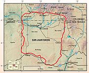
San Juan Basin
Encyclopedia
Southwestern United States
The Southwestern United States is a region defined in different ways by different sources. Broad definitions include nearly a quarter of the United States, including Arizona, California, Colorado, Nevada, New Mexico, Oklahoma, Texas and Utah...
United States
United States
The United States of America is a federal constitutional republic comprising fifty states and a federal district...
; its main portion covers around 4600 square miles (11,913.9 km²), encompassing much of northwestern New Mexico
New Mexico
New Mexico is a state located in the southwest and western regions of the United States. New Mexico is also usually considered one of the Mountain States. With a population density of 16 per square mile, New Mexico is the sixth-most sparsely inhabited U.S...
, southwest Colorado
Colorado
Colorado is a U.S. state that encompasses much of the Rocky Mountains as well as the northeastern portion of the Colorado Plateau and the western edge of the Great Plains...
, and parts of Arizona
Arizona
Arizona ; is a state located in the southwestern region of the United States. It is also part of the western United States and the mountain west. The capital and largest city is Phoenix...
and Utah
Utah
Utah is a state in the Western United States. It was the 45th state to join the Union, on January 4, 1896. Approximately 80% of Utah's 2,763,885 people live along the Wasatch Front, centering on Salt Lake City. This leaves vast expanses of the state nearly uninhabited, making the population the...
.
The region is arid
Arid
A region is said to be arid when it is characterized by a severe lack of available water, to the extent of hindering or even preventing the growth and development of plant and animal life...
with rugged topography of plain
Plain
In geography, a plain is land with relatively low relief, that is flat or gently rolling. Prairies and steppes are types of plains, and the archetype for a plain is often thought of as a grassland, but plains in their natural state may also be covered in shrublands, woodland and forest, or...
s and valley
Valley
In geology, a valley or dale is a depression with predominant extent in one direction. A very deep river valley may be called a canyon or gorge.The terms U-shaped and V-shaped are descriptive terms of geography to characterize the form of valleys...
s interspersed by butte
Butte
A butte is a conspicuous isolated hill with steep, often vertical sides and a small, relatively flat top; it is smaller than mesas, plateaus, and table landform tables. In some regions, such as the north central and northwestern United States, the word is used for any hill...
s, canyon
Canyon
A canyon or gorge is a deep ravine between cliffs often carved from the landscape by a river. Rivers have a natural tendency to reach a baseline elevation, which is the same elevation as the body of water it will eventually drain into. This forms a canyon. Most canyons were formed by a process of...
s and mesa
Mesa
A mesa or table mountain is an elevated area of land with a flat top and sides that are usually steep cliffs. It takes its name from its characteristic table-top shape....
s. Its most striking features include Chaco Canyon (northwestern New Mexico, between Farmington
Farmington, New Mexico
Farmington is a city in San Juan County in the U.S. state of New Mexico. As of the 2010 U.S. Census the city had a total population of 45,877 people. Farmington makes up one of the four Metropolitan Statistical Areas in New Mexico. The U.S...
and Santa Fe
Santa Fe, New Mexico
Santa Fe is the capital of the U.S. state of New Mexico. It is the fourth-largest city in the state and is the seat of . Santa Fe had a population of 67,947 in the 2010 census...
) and Chacra Mesa
Chacra Mesa
The Chacra Mesa is a high mesa massif composing the southwestern flank of Chaco Canyon, a region that is notable for its rich collection of ancient Chacoan Anasazi archaeological sites....
. The San Juan Basin also has uplands that exceed elevations of 9800 feet (2,987 m). Drainage in the structural basin is general westward from the Continental Divide of the Americas to the Mancos River
Mancos River
Mancos River is an tributary of the San Juan River. It flows from the confluence of West Mancos River and East Mancos River near Mancos, Colorado and joins the San Juan near Four Corners Monument in New Mexico.-See also:*List of rivers of Colorado...
's confluence with the San Juan River. The San Juan River then continues to the Colorado River
Colorado River
The Colorado River , is a river in the Southwestern United States and northwestern Mexico, approximately long, draining a part of the arid regions on the western slope of the Rocky Mountains. The watershed of the Colorado River covers in parts of seven U.S. states and two Mexican states...
.
Geology
The San Juan structural basin is a large downwarp of sedimentary rocks of mostly MesozoicMesozoic
The Mesozoic era is an interval of geological time from about 250 million years ago to about 65 million years ago. It is often referred to as the age of reptiles because reptiles, namely dinosaurs, were the dominant terrestrial and marine vertebrates of the time...
age. As a geologic region, the San Juan Basin is noted for its large deposits of coal
Coal
Coal is a combustible black or brownish-black sedimentary rock usually occurring in rock strata in layers or veins called coal beds or coal seams. The harder forms, such as anthracite coal, can be regarded as metamorphic rock because of later exposure to elevated temperature and pressure...
, uranium
Uranium
Uranium is a silvery-white metallic chemical element in the actinide series of the periodic table, with atomic number 92. It is assigned the chemical symbol U. A uranium atom has 92 protons and 92 electrons, of which 6 are valence electrons...
, and natural gas
Natural gas
Natural gas is a naturally occurring gas mixture consisting primarily of methane, typically with 0–20% higher hydrocarbons . It is found associated with other hydrocarbon fuel, in coal beds, as methane clathrates, and is an important fuel source and a major feedstock for fertilizers.Most natural...
. Since the 1980s, the Fruitland Formation
Fruitland Formation
The Fruitland Formation is a sedimentary geological formation containing layers of sandstone, shale, and coal. It was laid down in marshy delta conditions, with poor drainage and frequent flooding, under a warm, humid and seasonal climate...
in the basin has been one of the major US sources of coalbed methane
Coalbed methane
Coalbed methane or Coal Bed Methane, coalbed gas or coal mine methane is a form of natural gas extracted from coal beds. In recent decades it has become an important source of energy in United States, Canada, and other countries...
. In 2007, the San Juan Basin produced 1.32 trillion cubic feet of natural gas, making it the largest source of natural gas in the United States. Uranium mining in New Mexico
Uranium mining in New Mexico
Uranium mining in New Mexico, a state of the United States, was a significant industry from the early 1950s until the early 1980s. Although New Mexico has the second largest identified uranium ore reserves of any state in the US , no uranium ore has been mined in New Mexico since 1998.-White...
is also performed from the San Juan Basin.