
Helvellyn
Encyclopedia
Helvellyn is a mountain in the English Lake District
, the apex of the Eastern Fells
. At 950 metres (3,117 ft) above sea level, it is the third highest peak in both the Lake District and England
. The traditional border of Cumberland
and Westmorland
lies along the Helvellyn Ridge.
situated between the Thirlmere
valley to the west, and Patterdale
to the east. This ridge continues north over Helvellyn Lower Man, White Side
, Raise, Stybarrow Dodd
, Great Dodd
and Clough Head
, and south leads to Nethermost Pike
and Dollywaggon Pike
.
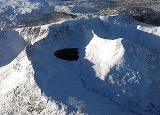
The eastern side of the fell is geographically the most dramatic. Two sharp arête
s lead off the summit, Striding Edge and Swirral Edge, either side of Red Tarn
. The knife-edged Striding Edge provides one of the best-known scrambles
in Lakeland, while the Swirral Edge ridge leads to the conical summit of Catstye Cam
.
Nestling between the encircling arms of Helvellyn's two edges, is Red Tarn
. This pool is named for the colour of the surrounding screes rather than its water, and contains brown trout and schelly, a fresh-water herring. The depth of Red Tarn is now about 80 feet (25m), although in the mid-19th century it was dammed with boulders to increase capacity. This was carried out to provide additional water to the Greenside lead
mine in Glenridding, the water race still visible as it crosses the slope of Birkhouse Moor
.
 A second tarn once existed in Brown Cove between Swirral Edge and Lower Man, but this now is reduced to a couple of small pools widening the stream. Brown Cove Tarn was another creation of the Greenside mine, a stone-faced dam being built in about 1860. The dam is still in place, but water now leaks through the base, the extended tarn-bed a smooth patch of luxuriant turf. A water leat passing beneath the north face of Catstye Cam to Red Tarn Beck can still be traced, although it is now in ruins. Water from Brown Cove and Red Tarn unites at the beyond Catstye Cam to form Glenridding Beck, flowing on through the village to Ullswater
.
The western slopes are relatively shallow, and partially forested, with many gills leading down to the Thirlmere
valley.
 The summit of Helvellyn takes the form of a broad plateau
about 500 metres (1,640 ft) long. The highest point is marked by a cairn and a cross-shaped dry stone
shelter; to the north is an Ordnance Survey
trig point
, a little lower than the summit at 949 m (3,114 ft).
There is a subsidiary top, Helvellyn Lower Man, about a third of a mile to the north-west. Its summit is small compared to the plateau of Helvellyn and offers better views north-westward, as the ground falls steeply away from it on this side.
According to Ordnance Survey
maps there is a bridleway along the full length of the Helvellyn range taking in a number of Wainwrights. This can be traversed by mountain bike
and the usual route is South to North starting from Mill Bridge. This challenging six-hour circular route is 16 miles off road and 10 on road.
Geologically, the summit area and Striding Edge are formed by the Deepdale formation of the Borrowdale Volcanic Group. This consists of volcaniclastic sandstone
with some intercalcated tuff
, pebbley sandstone breccia
, and lapilli
-tuff. Underlying this is the Helvellyn formation of dacitic
lapilli-tuff.
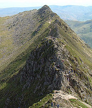 Striding Edge is a classic scrambling
route on Helvellyn, linking the summit ridge of Birkhouse Moor to Helvellyn's summit by what becomes a sharp arête
.
Striding Edge begins at Hole-in-the-Wall and then stretches for over a mile to the Helvellyn summit plateau. The initial part of the ridge is relatively rounded and has a good path running along the right hand side. This all changes upon reaching High Spying How, which at 863 m (2,831 ft) is the highest point on the ridge. At this point a narrow path continues closely to the top of the ridge which becomes increasingly narrow. Scramblers, however, will move to the top of the ridge and walk at the very top of the arête.
The side path continues until near the end of the ridge where it switches over to the left hand side. Scramblers are forced to descend a short gully down the last tower on the ridge. At this point the ridge joins to the main Helvellyn massif. All that remains is a walk or scramble up loose rocky terrain to reach the summit plateau around two hundred metres from the summit. Typically a cornice will form here in the winter and can represent the most dangerous part of the hike.
Striding Edge is a notorious accident spot among hikers and scramblers. Conditions on the ridge in early 2008 were described as the worst in thirty years by fell top assessor Craig Palmer. In winter conditions the climb from Striding Edge up to the summit plateau can involve an icy traverse of a dangerous cornice
. Without an ice axe
or crampons
this presents a serious obstacle. Two walkers died after falling from the ridge in separate incidents in the following weeks. Another walker died after falling from Striding Edge in May 2008.
as this gives the best views of Striding Edge, Red Tarn, and the summit of Helvellyn itself.
The weather should be taken into consideration when deciding to camp on Helvellyn. The weather can change suddenly, mist is also a problem at times. Although wild camping often is tolerated in the upland areas of the Lake District, it should be noted that camping wild is not legal without the permission of the landowner. No trace of your campsite should be left: this includes litter, ground disturbance, and human waste.
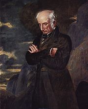 Helvellyn is strongly associated with the poet William Wordsworth
, who used to climb the mountain regularly. Benjamin Robert Haydon's painting Wordsworth on Helvellyn epitomises Romanticism
in portraiture. Wordsworth wrote about the mountain several times. In particular he commemorated the death of the artist, Charles Gough
, a tourist in the Lake District. Gough set out with his dog to cross Striding Edge to reach the peak of Helvellyn. He perished there and his dog stood at his side for three months before his corpse was found. A plaque commemorating this event can be found close to the peak.
The somewhat flat summit made the first British mountain-top landing of a plane possible, when John F. Leeming
and Bert Hinkler
successfully landed and took off again, in 1926. An academic, E.R. Dodds (1893–1979), Professor of Greek at the University of Birmingham, recorded the event, signing an old bill (receipt) to that effect, before they took off again. The event is marked by a slate which reads: "The first aeroplane to land on a mountain in Great Britain did so on this spot. On December 22nd 1926 John Leeming and Bert Hinkler in an AVRO 585 Gosport landed here and after a short stay flew back to Woodford".
The western slopes bear witness to historic mining activity. Helvellyn (or Wythburn) mine operated from 1839 until 1880, after which the land was acquired for the Thirlmere reservoir scheme. Four levels can be found along the course of Mines Gill, from where lead
was extracted. Despite the sizeable workings the venture was never a commercial success.
Lake District
The Lake District, also commonly known as The Lakes or Lakeland, is a mountainous region in North West England. A popular holiday destination, it is famous not only for its lakes and its mountains but also for its associations with the early 19th century poetry and writings of William Wordsworth...
, the apex of the Eastern Fells
Eastern Fells
The Eastern Fells are a group of hills in the English Lake District. Centred on Helvellyn they primarily comprise a north south ridge running between Ullswater and Lakeland's Central Valley.-Partition of the Lakeland Fells:...
. At 950 metres (3,117 ft) above sea level, it is the third highest peak in both the Lake District and England
England
England is a country that is part of the United Kingdom. It shares land borders with Scotland to the north and Wales to the west; the Irish Sea is to the north west, the Celtic Sea to the south west, with the North Sea to the east and the English Channel to the south separating it from continental...
. The traditional border of Cumberland
Cumberland
Cumberland is a historic county of North West England, on the border with Scotland, from the 12th century until 1974. It formed an administrative county from 1889 to 1974 and now forms part of Cumbria....
and Westmorland
Westmorland
Westmorland is an area of North West England and one of the 39 historic counties of England. It formed an administrative county from 1889 to 1974, after which the entirety of the county was absorbed into the new county of Cumbria.-Early history:...
lies along the Helvellyn Ridge.
Topography
The peak of Helvellyn is the highest on the north-south ridgeHelvellyn range
Helvellyn range is the name given to a part of the Eastern Fells in the English Lake District, fell being the local word for hill. The name comes from Helvellyn, the highest point of the group....
situated between the Thirlmere
Thirlmere
Thirlmere is a reservoir in the Borough of Allerdale in Cumbria and the English Lake District. It runs roughly south to north, with a dam at the northern end, and is bordered on the eastern side by the A591 road and on the western side by a minor road....
valley to the west, and Patterdale
Patterdale
Patterdale is a small village and civil parish in the eastern part of the English Lake District in the Eden District of Cumbria, and the long valley in which they are found, also called the Ullswater Valley....
to the east. This ridge continues north over Helvellyn Lower Man, White Side
White Side
White Side is a fell in the English Lake District. It is situated to the east of Thirlmere and to the west of Glenridding valley. This places White Side in the Helvellyn range of the Eastern Fells, with Raise to the north and Helvellyn Lower Man to the south, both of which are of greater...
, Raise, Stybarrow Dodd
Stybarrow Dodd
Stybarrow Dodd is a fell in the English Lake District. It stands on the main spine of the Helvellyn range in the Eastern Fells, situated between Thirlmere and the Ullswater catchment.-Topography:...
, Great Dodd
Great Dodd
Great Dodd is a fell in the English Lake District. It stands on the main spine of the Helvellyn range in the Eastern Fells, between the Vale of St John and Dockray.-Topography:...
and Clough Head
Clough Head
Clough Head is a fell in the English Lake District. It is the northernmost top of the Helvellyn range in the Eastern Fells, standing to the south of Threlkeld and the A66.-Topography:...
, and south leads to Nethermost Pike
Nethermost Pike
Nethermost Pike is a fell in Cumbria, England, and a part of the Lake District. At it is the second highest Wainwright in the Helvellyn range, the tallest of which is Helvellyn itself. It is located close to the southern end of the ridge, with Helvellyn to the north, and High Crag and Dollywaggon...
and Dollywaggon Pike
Dollywaggon Pike
Dollywaggon Pike is a fell in the English Lake District. It stands on the main spine of the Helvellyn range in the Eastern Fells, between Thirlmere and the Ullswater catchment.-Name:...
.
The eastern side of the fell is geographically the most dramatic. Two sharp arête
Arete
Areté is the term meaning "virtue" or "excellence", from Greek ἈρετήArete may also be used:*as a given name of persons or things:**Queen Arete , a character in Homer's Odyssey.***197 Arete, an asteroid....
s lead off the summit, Striding Edge and Swirral Edge, either side of Red Tarn
Red Tarn
Red Tarn is a small lake in the eastern region of the English Lake District, in the county of Cumbria. It is high up on the eastern flank of Helvellyn, beneath Striding Edge and Catstye Cam....
. The knife-edged Striding Edge provides one of the best-known scrambles
Scrambling
Scrambling is a method of ascending rocky faces and ridges. It is an ambiguous term that lies somewhere between hillwalking and rock climbing. It is often distinguished from hillwalking by defining a scramble as a route where hands must be used in the ascent...
in Lakeland, while the Swirral Edge ridge leads to the conical summit of Catstye Cam
Catstye Cam
Catstye Cam is a fell in the English Lake District. It is an outlier of Helvellyn in the Eastern Fells.-Name:The name of the fell is also given as 'Catstycam', a spelling preferred by Alfred Wainwright in his influential Pictorial Guide to the Lakeland Fells. A third variant, 'Catchedicam', is also...
.
Nestling between the encircling arms of Helvellyn's two edges, is Red Tarn
Tarn (lake)
A tarn is a mountain lake or pool, formed in a cirque excavated by a glacier. A moraine may form a natural dam below a tarn. A corrie may be called a cirque.The word is derived from the Old Norse word tjörn meaning pond...
. This pool is named for the colour of the surrounding screes rather than its water, and contains brown trout and schelly, a fresh-water herring. The depth of Red Tarn is now about 80 feet (25m), although in the mid-19th century it was dammed with boulders to increase capacity. This was carried out to provide additional water to the Greenside lead
Lead
Lead is a main-group element in the carbon group with the symbol Pb and atomic number 82. Lead is a soft, malleable poor metal. It is also counted as one of the heavy metals. Metallic lead has a bluish-white color after being freshly cut, but it soon tarnishes to a dull grayish color when exposed...
mine in Glenridding, the water race still visible as it crosses the slope of Birkhouse Moor
Birkhouse Moor
Birkhouse Moor is a fell in the English Lake District, an outlier of the Helvellyn range in the Eastern Fells. It is properly an eastern ridge of Helvellyn, but was treated as a separate fell by Alfred Wainwright in his Pictorial Guide to the Lakeland Fells...
.
Ullswater
Ullswater is the second largest lake in the English Lake District, being approximately nine miles long and 0.75 miles wide with a maximum depth of slightly more than ....
.
The western slopes are relatively shallow, and partially forested, with many gills leading down to the Thirlmere
Thirlmere
Thirlmere is a reservoir in the Borough of Allerdale in Cumbria and the English Lake District. It runs roughly south to north, with a dam at the northern end, and is bordered on the eastern side by the A591 road and on the western side by a minor road....
valley.
Plateau
In geology and earth science, a plateau , also called a high plain or tableland, is an area of highland, usually consisting of relatively flat terrain. A highly eroded plateau is called a dissected plateau...
about 500 metres (1,640 ft) long. The highest point is marked by a cairn and a cross-shaped dry stone
Dry stone
Dry stone is a building method by which structures are constructed from stones without any mortar to bind them together. Dry stone structures are stable because of their unique construction method, which is characterized by the presence of a load-bearing facade of carefully selected interlocking...
shelter; to the north is an Ordnance Survey
Ordnance Survey
Ordnance Survey , an executive agency and non-ministerial government department of the Government of the United Kingdom, is the national mapping agency for Great Britain, producing maps of Great Britain , and one of the world's largest producers of maps.The name reflects its creation together with...
trig point
Trig point
A triangulation station, also known as a triangulation pillar, trigonometrical station, trigonometrical point, trig station, trig beacon or trig point, and sometimes informally as a trig, is a fixed surveying station, used in geodetic surveying and other surveying projects in its vicinity...
, a little lower than the summit at 949 m (3,114 ft).
There is a subsidiary top, Helvellyn Lower Man, about a third of a mile to the north-west. Its summit is small compared to the plateau of Helvellyn and offers better views north-westward, as the ground falls steeply away from it on this side.
According to Ordnance Survey
Ordnance Survey
Ordnance Survey , an executive agency and non-ministerial government department of the Government of the United Kingdom, is the national mapping agency for Great Britain, producing maps of Great Britain , and one of the world's largest producers of maps.The name reflects its creation together with...
maps there is a bridleway along the full length of the Helvellyn range taking in a number of Wainwrights. This can be traversed by mountain bike
Mountain bike
A mountain bike or mountain bicycle is a bicycle created for off-road cycling. This activity includes traversing of rocks and washouts, and steep declines,...
and the usual route is South to North starting from Mill Bridge. This challenging six-hour circular route is 16 miles off road and 10 on road.
Geologically, the summit area and Striding Edge are formed by the Deepdale formation of the Borrowdale Volcanic Group. This consists of volcaniclastic sandstone
Sandstone
Sandstone is a sedimentary rock composed mainly of sand-sized minerals or rock grains.Most sandstone is composed of quartz and/or feldspar because these are the most common minerals in the Earth's crust. Like sand, sandstone may be any colour, but the most common colours are tan, brown, yellow,...
with some intercalcated tuff
Tuff
Tuff is a type of rock consisting of consolidated volcanic ash ejected from vents during a volcanic eruption. Tuff is sometimes called tufa, particularly when used as construction material, although tufa also refers to a quite different rock. Rock that contains greater than 50% tuff is considered...
, pebbley sandstone breccia
Breccia
Breccia is a rock composed of broken fragments of minerals or rock cemented together by a fine-grained matrix, that can be either similar to or different from the composition of the fragments....
, and lapilli
Lapilli
Lapilli is a size classification term for tephra, which is material that falls out of the air during a volcanic eruption or during some meteorite impacts. Lapilli means "little stones" in Latin. They are in some senses similar to ooids or pisoids in calcareous sediments.By definition lapilli range...
-tuff. Underlying this is the Helvellyn formation of dacitic
Dacite
Dacite is an igneous, volcanic rock. It has an aphanitic to porphyritic texture and is intermediate in composition between andesite and rhyolite. The relative proportions of feldspars and quartz in dacite, and in many other volcanic rocks, are illustrated in the QAPF diagram...
lapilli-tuff.
Striding Edge
Scrambling
Scrambling is a method of ascending rocky faces and ridges. It is an ambiguous term that lies somewhere between hillwalking and rock climbing. It is often distinguished from hillwalking by defining a scramble as a route where hands must be used in the ascent...
route on Helvellyn, linking the summit ridge of Birkhouse Moor to Helvellyn's summit by what becomes a sharp arête
Arete
Areté is the term meaning "virtue" or "excellence", from Greek ἈρετήArete may also be used:*as a given name of persons or things:**Queen Arete , a character in Homer's Odyssey.***197 Arete, an asteroid....
.
Striding Edge begins at Hole-in-the-Wall and then stretches for over a mile to the Helvellyn summit plateau. The initial part of the ridge is relatively rounded and has a good path running along the right hand side. This all changes upon reaching High Spying How, which at 863 m (2,831 ft) is the highest point on the ridge. At this point a narrow path continues closely to the top of the ridge which becomes increasingly narrow. Scramblers, however, will move to the top of the ridge and walk at the very top of the arête.
The side path continues until near the end of the ridge where it switches over to the left hand side. Scramblers are forced to descend a short gully down the last tower on the ridge. At this point the ridge joins to the main Helvellyn massif. All that remains is a walk or scramble up loose rocky terrain to reach the summit plateau around two hundred metres from the summit. Typically a cornice will form here in the winter and can represent the most dangerous part of the hike.
Striding Edge is a notorious accident spot among hikers and scramblers. Conditions on the ridge in early 2008 were described as the worst in thirty years by fell top assessor Craig Palmer. In winter conditions the climb from Striding Edge up to the summit plateau can involve an icy traverse of a dangerous cornice
Cornice (climbing)
A snow cornice or simply cornice is an overhanging edge of snow on a ridge or the crest of a mountain. They form by wind blowing snow over the crest of the mountain, so they often form on the leeward sides of mountains...
. Without an ice axe
Ice axe
An ice axe, is a multi-purpose ice and snow tool used by mountaineers both in the ascent and descent of routes which involve frozen conditions. It can be held and employed in a number of different ways, depending on the terrain encountered...
or crampons
Crampons
Crampons are traction devices used to improve mobility on snow and ice. There are three main attachment systems for footwear: step-in, hybrid, and strap bindings. The first two require boots with welts, the last adapt to any type....
this presents a serious obstacle. Two walkers died after falling from the ridge in separate incidents in the following weeks. Another walker died after falling from Striding Edge in May 2008.
Fell top assessors
The Lake District national park authority has two 'Fell top assessors' who ascend Helvellyn daily during the winter months of December to March. Their job is to check the weather conditions at the summit and write a report containing information such as temperature, windchill, windspeed, snowdepth, and any dangers such as unstable snow or avalanche hazard and icy footpaths. This report is put on the Weatherline, which is a Met Office mountain weather forecast and is available on the internet, by telephone and at local shops and tourist information centres. This information is important for people who go out winter hillwalking and climbing as it can help them plan their routes and to get an idea of the mountain conditions.Camping on Helvellyn
Because of the picturesque scenery that Helvellyn offers, many people camp on Helvellyn throughout the year. Many campers will set up camp around Red TarnRed Tarn
Red Tarn is a small lake in the eastern region of the English Lake District, in the county of Cumbria. It is high up on the eastern flank of Helvellyn, beneath Striding Edge and Catstye Cam....
as this gives the best views of Striding Edge, Red Tarn, and the summit of Helvellyn itself.
The weather should be taken into consideration when deciding to camp on Helvellyn. The weather can change suddenly, mist is also a problem at times. Although wild camping often is tolerated in the upland areas of the Lake District, it should be noted that camping wild is not legal without the permission of the landowner. No trace of your campsite should be left: this includes litter, ground disturbance, and human waste.
History
William Wordsworth
William Wordsworth was a major English Romantic poet who, with Samuel Taylor Coleridge, helped to launch the Romantic Age in English literature with the 1798 joint publication Lyrical Ballads....
, who used to climb the mountain regularly. Benjamin Robert Haydon's painting Wordsworth on Helvellyn epitomises Romanticism
Romanticism
Romanticism was an artistic, literary and intellectual movement that originated in the second half of the 18th century in Europe, and gained strength in reaction to the Industrial Revolution...
in portraiture. Wordsworth wrote about the mountain several times. In particular he commemorated the death of the artist, Charles Gough
Charles Gough (artist)
Charles Gough was an artist of the early English romantic movement in the 18th and 19th centuries. He did not achieve significant fame in his lifetime, but after his mysterious death in 1805, he became seen as a martyr, and an icon of the romantic vision...
, a tourist in the Lake District. Gough set out with his dog to cross Striding Edge to reach the peak of Helvellyn. He perished there and his dog stood at his side for three months before his corpse was found. A plaque commemorating this event can be found close to the peak.
The somewhat flat summit made the first British mountain-top landing of a plane possible, when John F. Leeming
John F. Leeming
John Fishwick Leeming was an English entrepreneur, businessman, early aviator, co-founder of the Lancashire Aero Club, gardener and author.- Early life and family :...
and Bert Hinkler
Bert Hinkler
Herbert John Louis Hinkler AFC DSM , better known as Bert Hinkler, was a pioneer Australian aviator and inventor. He designed and built early aircraft before being the first person to fly solo from England to Australia, and the first person to fly solo across the Southern Atlantic Ocean...
successfully landed and took off again, in 1926. An academic, E.R. Dodds (1893–1979), Professor of Greek at the University of Birmingham, recorded the event, signing an old bill (receipt) to that effect, before they took off again. The event is marked by a slate which reads: "The first aeroplane to land on a mountain in Great Britain did so on this spot. On December 22nd 1926 John Leeming and Bert Hinkler in an AVRO 585 Gosport landed here and after a short stay flew back to Woodford".
The western slopes bear witness to historic mining activity. Helvellyn (or Wythburn) mine operated from 1839 until 1880, after which the land was acquired for the Thirlmere reservoir scheme. Four levels can be found along the course of Mines Gill, from where lead
Lead
Lead is a main-group element in the carbon group with the symbol Pb and atomic number 82. Lead is a soft, malleable poor metal. It is also counted as one of the heavy metals. Metallic lead has a bluish-white color after being freshly cut, but it soon tarnishes to a dull grayish color when exposed...
was extracted. Despite the sizeable workings the venture was never a commercial success.
External links
- Striding Edge information
- Ullswater information centre latest information from centre at the foot of Helvellyn in Glenridding
- Helvellyn Pictures and Walks
- Computer-generated virtual panoramas North South Index
- Illustrated Lake District Guide
- Helvellyn Photo Guide
- Weatherline - Lake District weather forecast with daily weather report from summit of Helvellyn, December to March
- Lake District Walks - Helvellyn Via Striding Edge