

Central Fells
Encyclopedia
The Central Fells are a group of hills in the English
Lake District
. Reaching their highest point at High Raise
(2,500 ft or 762 metres), they occupy a broad area to the east of Borrowdale
. Perhaps unexpectedly the Central Fells are generally lower than the surrounding hills, the Lake District's general dome-like structure having a slight dip in the middle. The range extends from the boggy ridge between Derwentwater and Thirlmere
in the north, to the famous rock peaks of the Langdale Pikes in the south.
 The Lake District is a National Park
in the north west of the country which, in addition to its lake
s, contains a complex range of hills. These are locally known as fells and range from low hills to the highest ground in England. Hundreds of tops exist and many writers have attempted to draw up definitive lists
. In doing so the compilers frequently divide the range into smaller areas to aid their description.
The most influential of all such authors was Alfred Wainwright
whose Pictorial Guide to the Lakeland Fells
series has sold in excess of 2 million copies, being in print continuously since the first volume was published in 1952. Wainwright divided the fells into seven geographical areas, each surrounded by valleys and low passes. While any such division must be arbitrary- and later writers have deviated to a greater or lesser extent from this blueprint- Wainwright's sevenfold division remains the best known partitioning of the fells into 'sub ranges', each with its own characteristics. The Central Fells are one of these divisions, covered by volume 3 of Wainwright's work..
and the Northern Fells
. To the west runs the long valley of Borrowdale, flowing in this instance from Stake Pass at the head of Langstrath, all the way to Keswick. The parallel eastern boundary is created by Thirlmere and the Vale of St John, all of these valleys ultimately joining the River Derwent. At the head of Thirlmere is the pass of Dunmail Raise, crossed by the A591 road
. South of Dunmail Raise the Vale of Grasmere
runs down to Windermere
, forming the remainder of the eastern boundary. In the west, Stake Pass descends into Great Langdale
. This also descends, via the River Brathay, to Windermere.
As the name suggests, the Central Fells are the only group to be entirely surrounded by other Lakeland ranges. However, topographical links only exist with two of the surrounding groups. South west across Stake Pass are Rossett Pike
and the Southern Fells
while Dunmail Raise connects to Seat Sandal
in the Eastern Fells
. The North Western
and Western Fells
are cut off by the long gash of Borrowdale.
 The Central Fells when seen in plan best resemble a boot, although one facing the other way to Italy
. A broad ridge runs due south for about 10 miles, the valleys on either side being about 3 miles (5 km) apart. The range then narrows and turns south east, the Langdale Pikes forming the 'heel' and Loughrigg Fell
the 'toe'.
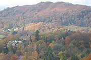
Beginning with Walla Crag
and Bleaberry Fell
in the north, the range climbs gradually to its apex at High Raise
, the 'ankle' of the boot analogy. This section is often termed the 'Central Ridge' and consists of flat topped peat covered hills. Many of the worst upland bogs of the District are in this area. South of Bleaberry Fell are High Seat
, High Tove
(home to The Peewits, the worst bog of all)and Ullscarf
, the land finally drying out here as High Raise is reached. To the west of the Central Ridge a lower spur encloses the quiet valley of Watendlath
. In this sector are Great Crag
and Grange Fell
, lower hills exposing more rock and popular as short climbs. On the eastern side a further low ridge surrounds Shoulthwaite, topped by the impressive Raven Crag
and family favourite High Rigg
.
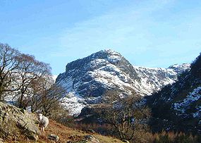
 High Raise itself is mostly grassy apart from the summit, and a broad plateau runs off south west over Thunacar Knott
. Beyond are a line of low tops, rimming this tableland and appearing nothing from this direction. From the south the true majesty of the Langdale Pikes is displayed, falling direct from their rock crowns to the valley floor of Great Langdale, nearly 2000 feet (609.6 m) below. Pike of Stickle
stands at the western end, followed by Loft Crag
, Harrison Stickle
and the great cliff of Pavey Ark
above Stickle Tarn
.
To the east of High Raise a complex system of minor ridges radiates out from the subsidiary top of Sergeant Man
. Rising between the valleys of Wythburn, Easedale and Greenburn are Calf Crag
, Helm Crag
, Gibson Knott
, Steel Fell
and Tarn Crag
. Along with Eagle Crag
and Sergeant's Crag
on the Borrowdale side these fells display steep flanks and plenty of rock on the summits.
The main ridge descends south east from High Raise as the ground between the Rivers Brothay and Rathay gradually narrows to a point at Ambleside
. In this section are the many tops of Blea Rigg
, Silver How
a fine viewpoint for Grasmere
and finally Loughrigg Fell
, easily accessible from White Moss car park and often combined with a walk along the terrace path above Rydal Water
.
In general, quieter walking can be had in the centre of the range from High Seat to Ullscarf, while many walkers will be met on Walla Crag or the Langdale Pikes.
England
England is a country that is part of the United Kingdom. It shares land borders with Scotland to the north and Wales to the west; the Irish Sea is to the north west, the Celtic Sea to the south west, with the North Sea to the east and the English Channel to the south separating it from continental...
Lake District
Lake District
The Lake District, also commonly known as The Lakes or Lakeland, is a mountainous region in North West England. A popular holiday destination, it is famous not only for its lakes and its mountains but also for its associations with the early 19th century poetry and writings of William Wordsworth...
. Reaching their highest point at High Raise
High Raise (Langdale)
High Raise is a fell in the Central Fells of the English Lake District not to be confused with another High Raise situated in the Far Eastern Fells...
(2,500 ft or 762 metres), they occupy a broad area to the east of Borrowdale
Borrowdale
Borrowdale is a valley and civil parish in the English Lake District in the Borough of Allerdale in Cumbria, England.Borrowdale lies within the historic county boundaries of Cumberland, and is sometimes referred to as Cumberland Borrowdale in order to distinguish it from another Borrowdale in the...
. Perhaps unexpectedly the Central Fells are generally lower than the surrounding hills, the Lake District's general dome-like structure having a slight dip in the middle. The range extends from the boggy ridge between Derwentwater and Thirlmere
Thirlmere
Thirlmere is a reservoir in the Borough of Allerdale in Cumbria and the English Lake District. It runs roughly south to north, with a dam at the northern end, and is bordered on the eastern side by the A591 road and on the western side by a minor road....
in the north, to the famous rock peaks of the Langdale Pikes in the south.
Partition of the Lakeland Fells
National park
A national park is a reserve of natural, semi-natural, or developed land that a sovereign state declares or owns. Although individual nations designate their own national parks differently A national park is a reserve of natural, semi-natural, or developed land that a sovereign state declares or...
in the north west of the country which, in addition to its lake
Lake
A lake is a body of relatively still fresh or salt water of considerable size, localized in a basin, that is surrounded by land. Lakes are inland and not part of the ocean and therefore are distinct from lagoons, and are larger and deeper than ponds. Lakes can be contrasted with rivers or streams,...
s, contains a complex range of hills. These are locally known as fells and range from low hills to the highest ground in England. Hundreds of tops exist and many writers have attempted to draw up definitive lists
Hill lists in the British Isles
The mountains and hills of Great Britain, and to a lesser extent Ireland, are the subject of a considerable number of lists that categorise them by height, topographic prominence, or other criteria. They are commonly used as a basis for peak bagging, whereby hillwalkers attempt to reach all the...
. In doing so the compilers frequently divide the range into smaller areas to aid their description.
The most influential of all such authors was Alfred Wainwright
Alfred Wainwright
Alfred Wainwright MBE was a British fellwalker, guidebook author and illustrator. His seven-volume Pictorial Guide to the Lakeland Fells, published between 1955 and 1966 and consisting entirely of reproductions of his manuscript, has become the standard reference work to 214 of the fells of the...
whose Pictorial Guide to the Lakeland Fells
Pictorial Guide to the Lakeland Fells
A Pictorial Guide to the Lakeland Fells is a series of seven books by A. Wainwright, detailing the fells of the Lake District in northwest England...
series has sold in excess of 2 million copies, being in print continuously since the first volume was published in 1952. Wainwright divided the fells into seven geographical areas, each surrounded by valleys and low passes. While any such division must be arbitrary- and later writers have deviated to a greater or lesser extent from this blueprint- Wainwright's sevenfold division remains the best known partitioning of the fells into 'sub ranges', each with its own characteristics. The Central Fells are one of these divisions, covered by volume 3 of Wainwright's work..
Boundaries
In the north is the Vale of Keswick, providing wide and total separation from SkiddawSkiddaw
Skiddaw is a mountain in the Lake District National Park in England. With a summit at 931 m above sea level it is the fourth highest mountain in England. It lies just north of the town of Keswick, Cumbria, and dominates the skyline in this part of the northern lakes...
and the Northern Fells
Northern Fells
The Northern Fells are a group of hills in the English Lake District. Including Skiddaw, they occupy a wide area to the north of Keswick. Smooth sweeping slopes predominate with a minimum of tarns or crags...
. To the west runs the long valley of Borrowdale, flowing in this instance from Stake Pass at the head of Langstrath, all the way to Keswick. The parallel eastern boundary is created by Thirlmere and the Vale of St John, all of these valleys ultimately joining the River Derwent. At the head of Thirlmere is the pass of Dunmail Raise, crossed by the A591 road
A591 road
The A591 is a major road in Cumbria, in the north-west of England. The stretch of the road between Windermere and Keswick has been voted Britain's Favourite Road.-Route:...
. South of Dunmail Raise the Vale of Grasmere
Grasmere
Grasmere is a village, and popular tourist destination, in the centre of the English Lake District. It takes its name from the adjacent lake, and is associated with the Lake Poets...
runs down to Windermere
Windermere (lake)
Windermere is the largest natural lake in England. It is a ribbon lake formed in a glacial trough after the retreat of ice at the start of the current interglacial. It has been one of the country’s most popular places for holidays and summer homes since the arrival of the Kendal and Windermere...
, forming the remainder of the eastern boundary. In the west, Stake Pass descends into Great Langdale
Great Langdale
Great Langdale is a valley in the Lake District National Park in the county of Cumbria, in the northwest of England. It is often simply referred to as Langdale, the epithet Great distinguishing it from the neighbouring valley of Little Langdale....
. This also descends, via the River Brathay, to Windermere.
As the name suggests, the Central Fells are the only group to be entirely surrounded by other Lakeland ranges. However, topographical links only exist with two of the surrounding groups. South west across Stake Pass are Rossett Pike
Rossett Pike
Rossett Pike is a fell in the English Lake District. It is located at the head of Mickleden, one of two tributary valleys of Great Langdale.-Topography:...
and the Southern Fells
Southern Fells
Image:Annotated Scafell range.jpg|thumb|300px|The Scafellsrect 23 372 252 419 Slight Side rect 173 794 560 834 Scafell East Buttressrect 707 787 893 861 Esk Pike or Crag rect 245 303 409 358 Sca Fell rect 408 238 637 280 Mickledore Image:Annotated Scafell range.jpg|thumb|300px|The Scafellsrect 23...
while Dunmail Raise connects to Seat Sandal
Seat Sandal
Seat Sandal is a fell in the English Lake District, it is situated four kilometers north of the village of Grasmere from where it is very well seen...
in the Eastern Fells
Eastern Fells
The Eastern Fells are a group of hills in the English Lake District. Centred on Helvellyn they primarily comprise a north south ridge running between Ullswater and Lakeland's Central Valley.-Partition of the Lakeland Fells:...
. The North Western
North Western Fells
The North Western Fells are a group of hills in the English Lake District. Including such favourites as Catbells and Grisedale Pike, they occupy an oval area beneath the Buttermere and Borrowdale valley systems...
and Western Fells
Western Fells
The Western Fells are a group of hills in the English Lake District. Centred on Great Gable they occupy a triangular area between Buttermere and Wasdale...
are cut off by the long gash of Borrowdale.
Topography
Italy
Italy , officially the Italian Republic languages]] under the European Charter for Regional or Minority Languages. In each of these, Italy's official name is as follows:;;;;;;;;), is a unitary parliamentary republic in South-Central Europe. To the north it borders France, Switzerland, Austria and...
. A broad ridge runs due south for about 10 miles, the valleys on either side being about 3 miles (5 km) apart. The range then narrows and turns south east, the Langdale Pikes forming the 'heel' and Loughrigg Fell
Loughrigg Fell
Loughrigg Fell is a hill in the central part of the English Lake District. It stands on the end of the long ridge coming down from High Raise over Silver How towards Ambleside, and is separated from its neighbours by the depression of Red Bank....
the 'toe'.
Beginning with Walla Crag
Walla Crag
Walla Crag is a fell in the English Lake District, near Keswick. The fell is a popular short walk from Keswick and gives superb views over Derwentwater...
and Bleaberry Fell
Bleaberry Fell
Bleaberry Fell is a fell in the Lake District in Cumbria, England, with a height of 590 metres . It stands on the main watershed between Borrowdale and Thirlmere and can be climbed from either flank...
in the north, the range climbs gradually to its apex at High Raise
High Raise (Langdale)
High Raise is a fell in the Central Fells of the English Lake District not to be confused with another High Raise situated in the Far Eastern Fells...
, the 'ankle' of the boot analogy. This section is often termed the 'Central Ridge' and consists of flat topped peat covered hills. Many of the worst upland bogs of the District are in this area. South of Bleaberry Fell are High Seat
High Seat (Lake District)
High Seat is a fell in the centre of the English Lake District. Despite being below 2,000 ft it is the highest point for about 5 miles in any direction; a consequence of the curious fact that the centre of the district is lower than the surrounding parts.-Topography:The main watershed of...
, High Tove
High Tove
High Tove is a fell in the English Lake District, close to the geographical centre of the Cumbrian hills. It forms part of the watershed between the Derwentwater and Thirlmere catchments, a ridge running broadly north-south.-Topography:...
(home to The Peewits, the worst bog of all)and Ullscarf
Ullscarf
Ullscarf is a fell in the English Lake District close to the geographical centre of the Cumbrian hills. It forms part of the watershed between the Derwentwater and Thirlmere catchments, a ridge running broadly north-south.-Topography:...
, the land finally drying out here as High Raise is reached. To the west of the Central Ridge a lower spur encloses the quiet valley of Watendlath
Watendlath
Watendlath is a hamlet and tarn in Cumbria in England.Watendlath is owned by the National Trust and sits high between the Borrowdale and Thirlmere valleys at above sea level.- Watendlath Tarn:...
. In this sector are Great Crag
Great Crag
Great Crag is a fell in the English Lake District, located near the hamlets of Rosthwaite and Stonethwaite in Borrowdale.-Topography:The higher slopes are heather-covered and quite rocky, while the lower steep slopes on the Borrowdale side are covered by a mature oak wood...
and Grange Fell
Grange Fell
Grange Fell is a small fell in the English Lake District in the county of Cumbria, situated in the Borrowdale valley overlooking the villages of Grange in Borrowdale and Rosthwaite.-Topography:...
, lower hills exposing more rock and popular as short climbs. On the eastern side a further low ridge surrounds Shoulthwaite, topped by the impressive Raven Crag
Raven Crag
Raven Crag is a fell in the English Lake District. It acts as a superb vantage point for, and backdrop to, views across Thirlmere reservoir.-Topography:...
and family favourite High Rigg
High Rigg
High Rigg is a small fell located in the English Lake District, approximately three miles southeast of the town of Keswick. It occupies an unusual position, surrounded on all sides by higher fells but not connected by any obvious ridge...
.
Thunacar Knott
Thunacar Knott is a fell in the central part of the English Lake District in the county of Cumbria.-Topography:The main spine of the Central Fells runs south from Bleaberry Fell to High Raise, before turning sharply east en route for Blea Rigg and Loughrigg Fell. A secondary ridge projects...
. Beyond are a line of low tops, rimming this tableland and appearing nothing from this direction. From the south the true majesty of the Langdale Pikes is displayed, falling direct from their rock crowns to the valley floor of Great Langdale, nearly 2000 feet (609.6 m) below. Pike of Stickle
Pike of Stickle
Pike of Stickle, also known as Pike O’ Stickle, is a fell in the English Lake District. It reaches a height of 709 metres and is situated in the central part of the national park in the valley of Great Langdale...
stands at the western end, followed by Loft Crag
Loft Crag
Loft Crag is a fell in the English Lake District, it is situated 9 kilometres west of Ambleside in the valley of Great Langdale and along with the neighbouring fells of Harrison Stickle and Pike of Stickle it forms the picturesque Langdale Pikes which when viewed from the area around...
, Harrison Stickle
Harrison Stickle
Harrison Stickle is a fell in the central part of the English Lake District, situated above Great Langdale. The fell is one of the three fells which make up the picturesque Langdale Pikes, the others being Pike of Stickle and Loft Crag. Together they make up one of the most picturesque, and...
and the great cliff of Pavey Ark
Pavey Ark
Pavey Ark is a fell in the English county of Cumbria. It is one of the Langdale Pikes, lying to the north of Great Langdale, in the heart of the Lake District, immediately to the north-east of Harrison Stickle.-Topography:...
above Stickle Tarn
Tarn (lake)
A tarn is a mountain lake or pool, formed in a cirque excavated by a glacier. A moraine may form a natural dam below a tarn. A corrie may be called a cirque.The word is derived from the Old Norse word tjörn meaning pond...
.
To the east of High Raise a complex system of minor ridges radiates out from the subsidiary top of Sergeant Man
Sergeant Man
Sergeant Man is a fell in the English Lake District. It is properly a secondary summit of High Raise, but is given a separate chapter by Alfred Wainwright in his third Pictorial Guide nonetheless, as it "is so prominent an object and offers so compelling a challenge"...
. Rising between the valleys of Wythburn, Easedale and Greenburn are Calf Crag
Calf Crag
Calf Crag is a fell in the English Lake District, on the eastern side of the High Raise massif.-Topography:The spine of the Central Fells runs on a north-south axis with the highpoint at High Raise...
, Helm Crag
Helm Crag
Helm Crag is a fell in the English Lake District situated in the Central Fells to the north of Grasmere. Despite its low height it sits prominently at the end of a ridge, easily seen from the village...
, Gibson Knott
Gibson Knott
Gibson Knott is a fell in the English Lake District, an intermediate height on the ridge between Greenburn and Far Easedale in the Central Fells.-Topography:The spine of the Central Fells runs on a north-south axis with the highpoint at High Raise...
, Steel Fell
Steel Fell
Steel Fell is a fell in the English Lake District, lying between Thirlmere and Grasmere. It is triangular in plan, the ridges running north, west and south east...
and Tarn Crag
Tarn Crag (Easedale)
Tarn Crag is a fell in the Central Fells of the English Lake District. Another Tarn Crag is situated in the Far Eastern Fells. Strictly the name applies only to the rock face looking down upon Easedale Tarn, but Alfred Wainwright applied it to the entire ridge lying between the Easedale and Far...
. Along with Eagle Crag
Eagle Crag
Eagle Crag is a fell in the Lake District in Cumbria, England, it is situated near the village of Stonethwaite where the valleys of Langstrath and Greenup join. Impressive walls of crag look down upon Stonethwaite, making Eagle Crag the most arresting sight from that settlement...
and Sergeant's Crag
Sergeant's Crag
Sergeant's Crag is a fell in the English Lake District. It is an intermediate height on the ridge between the Langstrath and Greenup valleys in the Central Fells.-Topography:...
on the Borrowdale side these fells display steep flanks and plenty of rock on the summits.
The main ridge descends south east from High Raise as the ground between the Rivers Brothay and Rathay gradually narrows to a point at Ambleside
Ambleside
Ambleside is a town in Cumbria, in North West England.Historically within the county of Westmorland, it is situated at the head of Windermere, England's largest lake...
. In this section are the many tops of Blea Rigg
Blea Rigg
Blea Rigg is a fell in the English Lake District, lying between the valleys of Easedale and Great Langdale. One of the Central Fells, it is a broad plateau with a succession of rocky tops...
, Silver How
Silver How
Silver How is a fell in the English Lake District, standing over the village of Grasmere. How, derived from the Old Norse word haugr, is a common local term for a hill or mound.-Topography:...
a fine viewpoint for Grasmere
Grasmere
Grasmere is a village, and popular tourist destination, in the centre of the English Lake District. It takes its name from the adjacent lake, and is associated with the Lake Poets...
and finally Loughrigg Fell
Loughrigg Fell
Loughrigg Fell is a hill in the central part of the English Lake District. It stands on the end of the long ridge coming down from High Raise over Silver How towards Ambleside, and is separated from its neighbours by the depression of Red Bank....
, easily accessible from White Moss car park and often combined with a walk along the terrace path above Rydal Water
Rydal Water
Rydal Water is a small lake in the central part of the English Lake District, in the county of Cumbria. It is located near the hamlet of Rydal, between Grasmere and Ambleside in the Rothay Valley....
.
Access for walkers
In the north, Walla Crag and Bleaberry fell are an easy walk from Keswick, while the Borrowdale road provides access as far south as Eagle Crag and the foot of Langstrath. The A591 road runs the full length of the range in the east, and in combination with the minor road around Thirlmere gives good access at many points. Grasmere village is also a useful starting place for walks around Easedale and Far Easedale. The Langdale Pikes are generally climbed from Great Langdale, beginning from either of the Dungeon Ghyll Hotels. Loughrigg is surrounded by minor roads, including Red Bank, the only one crossing the Central Fells. Near the summit is the youth hostel of High Close.In general, quieter walking can be had in the centre of the range from High Seat to Ullscarf, while many walkers will be met on Walla Crag or the Langdale Pikes.
See also
- Eastern FellsEastern FellsThe Eastern Fells are a group of hills in the English Lake District. Centred on Helvellyn they primarily comprise a north south ridge running between Ullswater and Lakeland's Central Valley.-Partition of the Lakeland Fells:...
- Far Eastern FellsFar Eastern FellsThe Far Eastern Fells are a group of hills in the English Lake District. Reaching their highest point at High Street they occupy a broad area to the east of Ullswater and Kirkstone Pass. Much quieter than the central areas of Lakeland they offer in general easier but less exciting walking as the...
- Southern FellsSouthern FellsImage:Annotated Scafell range.jpg|thumb|300px|The Scafellsrect 23 372 252 419 Slight Side rect 173 794 560 834 Scafell East Buttressrect 707 787 893 861 Esk Pike or Crag rect 245 303 409 358 Sca Fell rect 408 238 637 280 Mickledore Image:Annotated Scafell range.jpg|thumb|300px|The Scafellsrect 23...
- Northern FellsNorthern FellsThe Northern Fells are a group of hills in the English Lake District. Including Skiddaw, they occupy a wide area to the north of Keswick. Smooth sweeping slopes predominate with a minimum of tarns or crags...
- North Western FellsNorth Western FellsThe North Western Fells are a group of hills in the English Lake District. Including such favourites as Catbells and Grisedale Pike, they occupy an oval area beneath the Buttermere and Borrowdale valley systems...
- Western FellsWestern FellsThe Western Fells are a group of hills in the English Lake District. Centred on Great Gable they occupy a triangular area between Buttermere and Wasdale...