
Seat Sandal
Encyclopedia
Fell
“Fell” is a word used to refer to mountains, or certain types of mountainous landscape, in Scandinavia, the Isle of Man, and parts of northern England.- Etymology :...
in the English
England
England is a country that is part of the United Kingdom. It shares land borders with Scotland to the north and Wales to the west; the Irish Sea is to the north west, the Celtic Sea to the south west, with the North Sea to the east and the English Channel to the south separating it from continental...
Lake District
Lake District
The Lake District, also commonly known as The Lakes or Lakeland, is a mountainous region in North West England. A popular holiday destination, it is famous not only for its lakes and its mountains but also for its associations with the early 19th century poetry and writings of William Wordsworth...
, it is situated four kilometers north of the village of Grasmere
Grasmere
Grasmere is a village, and popular tourist destination, in the centre of the English Lake District. It takes its name from the adjacent lake, and is associated with the Lake Poets...
from where it is very well seen. Nevertheless, it tends to be overshadowed by its more illustrious neighbours in the Eastern Fells
Eastern Fells
The Eastern Fells are a group of hills in the English Lake District. Centred on Helvellyn they primarily comprise a north south ridge running between Ullswater and Lakeland's Central Valley.-Partition of the Lakeland Fells:...
, Helvellyn
Helvellyn
Helvellyn is a mountain in the English Lake District, the apex of the Eastern Fells. At above sea level, it is the third highest peak in both the Lake District and England...
and Fairfield
Fairfield (Lake District)
Fairfield is a fell in the English Lake District. It is the highest of a group of hills in the Eastern Fells, standing to the south of the Helvellyn range.-Topography:...
.
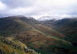
Topography
The fells western flanks above Dunmail RaiseDunmail Raise
Dunmail Raise is a hill in the English Lake District, the highest point of a pass on the Keswick-Kendal road, the A591, to the south of Thirlmere reservoir on the way to Grasmere, in the Lake District National Park...
are grassy and smooth while its eastern slopes are steep and craggy as they fall away towards Grisedale Hause which at 537 m (1,761 ft) contains Lakeland's highest substantial tarn, Grisedale Tarn. The fell reaches a height of 736 m (2,415 ft) and just scrapes into the list of Marilyns
Marilyn (hill)
A Marilyn is a mountain or hill in the United Kingdom, Republic of Ireland or Isle of Man with a relative height of at least 150 metres , regardless of absolute height or other merit...
by being given prominence
Topographic prominence
In topography, prominence, also known as autonomous height, relative height, shoulder drop , or prime factor , categorizes the height of the mountain's or hill's summit by the elevation between it and the lowest contour line encircling it and no higher summit...
of "around" 150 metres from the higher fell of Fairfield, however this must be a borderline case as there is no Ordnance Survey
Ordnance Survey
Ordnance Survey , an executive agency and non-ministerial government department of the Government of the United Kingdom, is the national mapping agency for Great Britain, producing maps of Great Britain , and one of the world's largest producers of maps.The name reflects its creation together with...
surveyed height for the top of Grisedale Hause. Alfred Wainwright
Alfred Wainwright
Alfred Wainwright MBE was a British fellwalker, guidebook author and illustrator. His seven-volume Pictorial Guide to the Lakeland Fells, published between 1955 and 1966 and consisting entirely of reproductions of his manuscript, has become the standard reference work to 214 of the fells of the...
gives it a height of 1929 feet (588 metres) giving Seat Sandal a topographic prominence of only 148 metres (two metres short of Marilyn qualification). The hills unusual name comes from the Norse language, meaning “Sandulf’s Hill Pasture”, Sandulf being a Nordic
Nordic countries
The Nordic countries make up a region in Northern Europe and the North Atlantic which consists of Denmark, Finland, Iceland, Norway and Sweden and their associated territories, the Faroe Islands, Greenland and Åland...
personal name.
Seat Sandal is distinctive in that its drainage
Drainage
Drainage is the natural or artificial removal of surface and sub-surface water from an area. Many agricultural soils need drainage to improve production or to manage water supplies.-Early history:...
reaches the sea at more widely spread points than any other Lakeland Fell, with Raise Beck going through Thirlmere
Thirlmere
Thirlmere is a reservoir in the Borough of Allerdale in Cumbria and the English Lake District. It runs roughly south to north, with a dam at the northern end, and is bordered on the eastern side by the A591 road and on the western side by a minor road....
and Derwent Water
Derwent Water
Derwentwater is one of the principal bodies of water in the Lake District National Park in north west England. It lies wholly within the Borough of Allerdale, in the county of Cumbria....
to reach the Irish Sea
Irish Sea
The Irish Sea separates the islands of Ireland and Great Britain. It is connected to the Celtic Sea in the south by St George's Channel, and to the Atlantic Ocean in the north by the North Channel. Anglesey is the largest island within the Irish Sea, followed by the Isle of Man...
at Workington
Workington
Workington is a town, civil parish and port on the west coast of Cumbria, England, at the mouth of the River Derwent. Lying within the Borough of Allerdale, Workington is southwest of Carlisle, west of Cockermouth, and southwest of Maryport...
, Tongue Beck going through the lakes of Grasmere
Grasmere (lake)
Grasmere is one of the smaller lakes of the English Lake District, in the county of Cumbria. It gives its name to the village of Grasmere, famously associated with the poet William Wordsworth, which lies immediately to the north of the lake....
and Windermere
Windermere (lake)
Windermere is the largest natural lake in England. It is a ribbon lake formed in a glacial trough after the retreat of ice at the start of the current interglacial. It has been one of the country’s most popular places for holidays and summer homes since the arrival of the Kendal and Windermere...
to reach Morecambe Bay
Morecambe Bay
Morecambe Bay is a large bay in northwest England, nearly due east of the Isle of Man and just to the south of the Lake District National Park. It is the largest expanse of intertidal mudflats and sand in the United Kingdom, covering a total area of 310 km².-Natural features:The rivers Leven,...
and Grisedale Beck draining into Ullswater
Ullswater
Ullswater is the second largest lake in the English Lake District, being approximately nine miles long and 0.75 miles wide with a maximum depth of slightly more than ....
and then to the sea at the Solway Firth
Solway Firth
The Solway Firth is a firth that forms part of the border between England and Scotland, between Cumbria and Dumfries and Galloway. It stretches from St Bees Head, just south of Whitehaven in Cumbria, to the Mull of Galloway, on the western end of Dumfries and Galloway. The Isle of Man is also very...
. However, this is only true as a result of the diversion of Raise Beck north to feed Thirlmere Reservoir - before this (and still today when there is enough water in Raise Beck for it to flow both north and south), Dollywaggon Pike
Dollywaggon Pike
Dollywaggon Pike is a fell in the English Lake District. It stands on the main spine of the Helvellyn range in the Eastern Fells, between Thirlmere and the Ullswater catchment.-Name:...
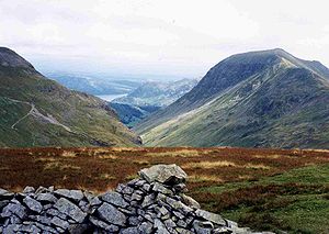
had in this distinction - Birkside Gill feeding Thirlmere, Raise Beck feeding Grasmere, and Grisedale Beck feeding Ullswater. The fell's main topographic attraction is Gavel Crag on its eastern side, which is connected to the main body of the fell by a fine rock arete.
Dunmail Raise provides the topographical connection between the Eastern and Central Fells
Central Fells
The Central Fells are a group of hills in the English Lake District. Reaching their highest point at High Raise , they occupy a broad area to the east of Borrowdale. Perhaps unexpectedly the Central Fells are generally lower than the surrounding hills, the Lake District's general dome-like...
, Steel Fell
Steel Fell
Steel Fell is a fell in the English Lake District, lying between Thirlmere and Grasmere. It is triangular in plan, the ridges running north, west and south east...
rising on the other side of the pass.
Geology
A ill of andesiteAndesite
Andesite is an extrusive igneous, volcanic rock, of intermediate composition, with aphanitic to porphyritic texture. In a general sense, it is the intermediate type between basalt and dacite. The mineral assemblage is typically dominated by plagioclase plus pyroxene and/or hornblende. Magnetite,...
lava
Lava
Lava refers both to molten rock expelled by a volcano during an eruption and the resulting rock after solidification and cooling. This molten rock is formed in the interior of some planets, including Earth, and some of their satellites. When first erupted from a volcanic vent, lava is a liquid at...
forms the summit, the rocks beneath being the dacitic
Dacite
Dacite is an igneous, volcanic rock. It has an aphanitic to porphyritic texture and is intermediate in composition between andesite and rhyolite. The relative proportions of feldspars and quartz in dacite, and in many other volcanic rocks, are illustrated in the QAPF diagram...
lapilli
Lapilli
Lapilli is a size classification term for tephra, which is material that falls out of the air during a volcanic eruption or during some meteorite impacts. Lapilli means "little stones" in Latin. They are in some senses similar to ooids or pisoids in calcareous sediments.By definition lapilli range...
-tuff
Tuff
Tuff is a type of rock consisting of consolidated volcanic ash ejected from vents during a volcanic eruption. Tuff is sometimes called tufa, particularly when used as construction material, although tufa also refers to a quite different rock. Rock that contains greater than 50% tuff is considered...
s of the Lincomb Tarns Formation.
Ascents
The fell can be ascended from Grasmere or Dunmail Raise although a start from PatterdalePatterdale
Patterdale is a small village and civil parish in the eastern part of the English Lake District in the Eden District of Cumbria, and the long valley in which they are found, also called the Ullswater Valley....
is quite feasible. The Grasmere or Patterdale starts use the old packhorse
Packhorse
.A packhorse or pack horse refers generally to an equid such as a horse, mule, donkey or pony used for carrying goods on their backs, usually carried in sidebags or panniers. Typically packhorses are used to cross difficult terrain, where the absence of roads prevents the use of wheeled vehicles. ...
route that links the two places; this is now part of Wainwright’s Coast to Coast Walk
Coast to Coast Walk
The Coast to Coast Walk is a 192-mile unofficial and mostly unsignposted long distance footpath in Northern England...
. When Grisedale Hause is reached it is a steep climb to the summit following a broken wall. The ascent from Dunmail Raise follows the bed of Raise Beck until it peters out at a height of 580 m (1,900 ft), it is then a walk south up easy slopes to reach the summit. There is also a direct ascent up the western slopes starting at Mill Bridge.