
Clough Head
Encyclopedia
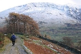
Clough Head is a fell
in the English
Lake District
. It is the northernmost top of the Helvellyn range
in the Eastern Fells
, standing to the south of Threlkeld
and the A66
.
runs broadly north to south for about 7 miles (11.3 km), remaining above 2,000 ft (600 m) throughout its length. To the south of the terminus at Clough Head are Great Dodd
, Watson's Dodd
and Stybarrow Dodd
- collectively 'The Dodds'- before the scenery becomes gradually wilder on the approach to Helvellyn
itself.
Clough Head is the lowest of the range, and from some directions it appears as a rounded grassy dome. Alone among the Helvellyns it has smooth slopes to the east, with crags on the west, a reversal of the usual pattern. The crags continue around to the north west above the village of Threlkeld, forming a large natural amphitheatre
.
The connecting ridge from Great Dodd begins westerly before swinging north around the head of Mosedale, the boundary between these two fells. The halfway point is marked by Calfhow Pike (2,165 ft), a tor. This would be unremarkable in other parts of the district, but here the lone rocky island in a sea of fell-grass is a landmark for miles around. North of Calfhow Pike is a col
at 2020 ft (615.7 m) before the broad ridge makes directly for the summit of Clough Head.
The steep drop of Red Screes begins almost immediately to the north west of the summit, falling to the floor of the unnamed amphitheatre at around 1650 ft (502.9 m) The outlet of this corrie contains the subsidiary top of Threlkeld Knotts, deflecting the drainage to either side. Gentler slopes lead down from here to the hamlet of Wanthwaite and the remains of Threlkeld Quarry, now Threlkeld Mining Museum. Also nearby are the remains of an ancient Settlement, believed to date from the Romano-British period. Outlines of enclosure walls can still be clearly seen.
North east from the summit of Clough Head is the lesser top of White Pike. From here the ridge descends between Mosedale and Red Screes, gradually broadening into Thelkeld Common before it reaches the River Glenderamackin some two miles (3 km) away.
The western face of Clough Head, looming above the Vale of St John, is uniformly rough. The principal rock features are, from the north, Buck Castle, Wanthwaite Crags and Bram Crag. Rising up between the latter two in a south easterly direction is Fisher's Wife's Rake, the only chink in Clough Head's defences on this side. A (very) steep grassy trod rises up from the scree below Wanthwaite Crags, climbing to the smoother ground above. It is practicable although not for the casual walker. The name comes from the Fisher family of nearby Rake How- the husband cut peat
and his wife hauled it down by sled.
to Matterdale
. This has suffered damage from use by off-road vehicles in recent years, but such activity is currently prohibited. Near the road summit is Hause Well, a spring issuing from a crevice in the rock.
. In addition behind Lowthwaite Farm are the remains of Wanthwaite Crag Mine. Several levels were driven here along a system of lead
and copper
veins, the most recent lease being taken out in 1887. Geologically, the area to the north of the top is characterised by an intrusion of microgranite, while various members of the Borrowdale Volcanic series occur to the south.
triangulation column and a sprawling cairn
-cum-windbreak. It provides a good view of Blencathra to the north, in fact Alfred Wainwright
drew himself admiring this view in his Pictorial Guides to the Lakeland Fells. Although the higher Great Dodd obstructs, the vista of the high fells to the west is excellent.
Fell
“Fell” is a word used to refer to mountains, or certain types of mountainous landscape, in Scandinavia, the Isle of Man, and parts of northern England.- Etymology :...
in the English
England
England is a country that is part of the United Kingdom. It shares land borders with Scotland to the north and Wales to the west; the Irish Sea is to the north west, the Celtic Sea to the south west, with the North Sea to the east and the English Channel to the south separating it from continental...
Lake District
Lake District
The Lake District, also commonly known as The Lakes or Lakeland, is a mountainous region in North West England. A popular holiday destination, it is famous not only for its lakes and its mountains but also for its associations with the early 19th century poetry and writings of William Wordsworth...
. It is the northernmost top of the Helvellyn range
Helvellyn range
Helvellyn range is the name given to a part of the Eastern Fells in the English Lake District, fell being the local word for hill. The name comes from Helvellyn, the highest point of the group....
in the Eastern Fells
Eastern Fells
The Eastern Fells are a group of hills in the English Lake District. Centred on Helvellyn they primarily comprise a north south ridge running between Ullswater and Lakeland's Central Valley.-Partition of the Lakeland Fells:...
, standing to the south of Threlkeld
Threlkeld
Threlkeld is a village and civil parish in the north of the Lake District in Cumbria, England, to the east of Keswick. It lies at the southern foot of Blencathra, one of the more prominent fells in the northern Lake District, and to the north of the River Glenderamackin.Historically a part of...
and the A66
A66 road
The A66 is a major road in northern England which in part follows the course of the Roman road from Scotch Corner to Penrith. It runs from east of Middlesbrough in the ceremonial county of North Yorkshire to Workington in Cumbria...
.
Topography
The Helvellyn rangeHelvellyn range
Helvellyn range is the name given to a part of the Eastern Fells in the English Lake District, fell being the local word for hill. The name comes from Helvellyn, the highest point of the group....
runs broadly north to south for about 7 miles (11.3 km), remaining above 2,000 ft (600 m) throughout its length. To the south of the terminus at Clough Head are Great Dodd
Great Dodd
Great Dodd is a fell in the English Lake District. It stands on the main spine of the Helvellyn range in the Eastern Fells, between the Vale of St John and Dockray.-Topography:...
, Watson's Dodd
Watson's Dodd
Watson's Dodd is a fell in the English Lake District. It forms part of the Helvellyn range in the Eastern Fells. This chain of hills runs north-south and, in the vicinity of Watson's Dodd, forms the watershed between the Thirlmere and Ullswater catchments....
and Stybarrow Dodd
Stybarrow Dodd
Stybarrow Dodd is a fell in the English Lake District. It stands on the main spine of the Helvellyn range in the Eastern Fells, situated between Thirlmere and the Ullswater catchment.-Topography:...
- collectively 'The Dodds'- before the scenery becomes gradually wilder on the approach to Helvellyn
Helvellyn
Helvellyn is a mountain in the English Lake District, the apex of the Eastern Fells. At above sea level, it is the third highest peak in both the Lake District and England...
itself.
Clough Head is the lowest of the range, and from some directions it appears as a rounded grassy dome. Alone among the Helvellyns it has smooth slopes to the east, with crags on the west, a reversal of the usual pattern. The crags continue around to the north west above the village of Threlkeld, forming a large natural amphitheatre
Cirque
Cirque may refer to:* Cirque, a geological formation* Makhtesh, an erosional landform found in the Negev desert of Israel and Sinai of Egypt*Cirque , an album by Biosphere* Cirque Corporation, a company that makes touchpads...
.
The connecting ridge from Great Dodd begins westerly before swinging north around the head of Mosedale, the boundary between these two fells. The halfway point is marked by Calfhow Pike (2,165 ft), a tor. This would be unremarkable in other parts of the district, but here the lone rocky island in a sea of fell-grass is a landmark for miles around. North of Calfhow Pike is a col
Mountain pass
A mountain pass is a route through a mountain range or over a ridge. If following the lowest possible route, a pass is locally the highest point on that route...
at 2020 ft (615.7 m) before the broad ridge makes directly for the summit of Clough Head.
The steep drop of Red Screes begins almost immediately to the north west of the summit, falling to the floor of the unnamed amphitheatre at around 1650 ft (502.9 m) The outlet of this corrie contains the subsidiary top of Threlkeld Knotts, deflecting the drainage to either side. Gentler slopes lead down from here to the hamlet of Wanthwaite and the remains of Threlkeld Quarry, now Threlkeld Mining Museum. Also nearby are the remains of an ancient Settlement, believed to date from the Romano-British period. Outlines of enclosure walls can still be clearly seen.
North east from the summit of Clough Head is the lesser top of White Pike. From here the ridge descends between Mosedale and Red Screes, gradually broadening into Thelkeld Common before it reaches the River Glenderamackin some two miles (3 km) away.
The western face of Clough Head, looming above the Vale of St John, is uniformly rough. The principal rock features are, from the north, Buck Castle, Wanthwaite Crags and Bram Crag. Rising up between the latter two in a south easterly direction is Fisher's Wife's Rake, the only chink in Clough Head's defences on this side. A (very) steep grassy trod rises up from the scree below Wanthwaite Crags, climbing to the smoother ground above. It is practicable although not for the casual walker. The name comes from the Fisher family of nearby Rake How- the husband cut peat
Peat
Peat is an accumulation of partially decayed vegetation matter or histosol. Peat forms in wetland bogs, moors, muskegs, pocosins, mires, and peat swamp forests. Peat is harvested as an important source of fuel in certain parts of the world...
and his wife hauled it down by sled.
Old Coach Road
An old route, marked on maps as "Old Coach Road" crosses the northeastern slopes of Clough Head, reaching a high point of 437 m (1,435 ft) as it crosses from St John's in the ValeSt John's in the Vale
St John's in the Vale is a glacial valley in the Lake District National Park, Cumbria, England. Within the vale are a number of farms and small settlements, in addition to several disused quarry and mining works. St Johns Beck meanders northward along the floor of the vale, and is the primary route...
to Matterdale
Matterdale
Matterdale is a civil parish in the Eden District of Cumbria, England. It has a population of 526....
. This has suffered damage from use by off-road vehicles in recent years, but such activity is currently prohibited. Near the road summit is Hause Well, a spring issuing from a crevice in the rock.
Geology, Mines and Quarries
The western face of Clough Head is extensively marked by quarrying. In addition to Thelkeld Quarry were Birkett Bank, Hill Top, Wanthwaite and Bram Crag Quarries, all of which were worked for graniteGranite
Granite is a common and widely occurring type of intrusive, felsic, igneous rock. Granite usually has a medium- to coarse-grained texture. Occasionally some individual crystals are larger than the groundmass, in which case the texture is known as porphyritic. A granitic rock with a porphyritic...
. In addition behind Lowthwaite Farm are the remains of Wanthwaite Crag Mine. Several levels were driven here along a system of lead
Lead
Lead is a main-group element in the carbon group with the symbol Pb and atomic number 82. Lead is a soft, malleable poor metal. It is also counted as one of the heavy metals. Metallic lead has a bluish-white color after being freshly cut, but it soon tarnishes to a dull grayish color when exposed...
and copper
Copper
Copper is a chemical element with the symbol Cu and atomic number 29. It is a ductile metal with very high thermal and electrical conductivity. Pure copper is soft and malleable; an exposed surface has a reddish-orange tarnish...
veins, the most recent lease being taken out in 1887. Geologically, the area to the north of the top is characterised by an intrusion of microgranite, while various members of the Borrowdale Volcanic series occur to the south.
Summit and View
The summit is marked by an Ordnance SurveyOrdnance Survey
Ordnance Survey , an executive agency and non-ministerial government department of the Government of the United Kingdom, is the national mapping agency for Great Britain, producing maps of Great Britain , and one of the world's largest producers of maps.The name reflects its creation together with...
triangulation column and a sprawling cairn
Cairn
Cairn is a term used mainly in the English-speaking world for a man-made pile of stones. It comes from the or . Cairns are found all over the world in uplands, on moorland, on mountaintops, near waterways and on sea cliffs, and also in barren desert and tundra areas...
-cum-windbreak. It provides a good view of Blencathra to the north, in fact Alfred Wainwright
Alfred Wainwright
Alfred Wainwright MBE was a British fellwalker, guidebook author and illustrator. His seven-volume Pictorial Guide to the Lakeland Fells, published between 1955 and 1966 and consisting entirely of reproductions of his manuscript, has become the standard reference work to 214 of the fells of the...
drew himself admiring this view in his Pictorial Guides to the Lakeland Fells. Although the higher Great Dodd obstructs, the vista of the high fells to the west is excellent.