
East Gippsland Rail Trail
Encyclopedia
The East Gippsland Rail Trail is a rail trail
located in East Gippsland
in Victoria
, Australia
. The trail is a popular cycling
route, beginning in Bairnsdale and extending to Orbost
, following the route of the former Orbost railway line
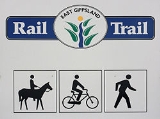
. The shared trail is also available for walkers
and recreational horseriding
, however motorised vehicles are prohibited.
The trail is 96 kilometres (59.7 mi) long and passes through a variety of forest and farmland landscapes with occasional views of the Gippsland Lakes
. Parts of the trail are accessible to any bicycle
, but significant sections are suitable only for mountain bike
s or sturdy hybrid bikes
.
, Bruthen
, Nowa Nowa
, and Newmerella, with a short connecting path taking it into Orbost
. Water and most facilities are only available in these towns, so trail users are required to be self-sufficient. The trail follows the long gradual inclines and sweeping curves of the former railway line, reaching a maximum altitude of 129 m at Colquhoun.
Along its route it passes the former railway stations
and/or sidings at Nicholson, Bumberrah, Mossiface, Bruthen, Colquhoun, Nowa Nowa, Tostaree, Waygara, and Orbost. It passes across or past a number of former railway bridges including some large trestle bridges, and starts alongside the Mitchell River
and crosses the Nicholson River
, Tambo River
and Snowy River
, as well as several minor watercourse
s on its way to Orbost.
railway station itself due to the poor condition of the old rail bridge over the Mitchell River
. The trail begins on the south side of the Princes Highway
opposite the Howitt Park sports grounds at McEacharn Street.
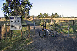
The rail trail is accessible from the town via the road or footpath on the Princes Highway road bridge across the river. Toilet
s and good car parking
facilities are available in the main section of Howitt Park on the north side of Princes Highway. Safe access to the south side of the highway and the rail trail can be obtained by following the path alongside the Mitchell River under the road bridge and up to road level, then along between the highway and the Howitt Park sports grounds.
The trail travels east from Bairnsdale following the route of the old railway line and roughly follows the line of the Princes Highway. The trail initially passes between industrial and retail properties leading out of Bairnsdale, then travels mainly through open farmland, predominantly for cattle and horse grazing, to the town of Nicholson
.
There are distant views of the Gippsland Lakes
in some sections, and a number of crossings of minor roads are required, as well an unsigned crossing of the Princes Highway. The surface is sealed with asphalt
and is in fair to good condition as far as the Nicholson River
bridge in Nicholson, 9 km from the start of the route. The bridge is the former railway bridge across the river, now sealed with concrete, while just before the bridge is a station name board marking the site of the former Nicholson railway station.
The trail passes just to the north of the Nicholson
township. Access to the town itself can be gained either by turning south at the Nicolson-Sarsfield Road, or by following a minor track along the west side of the Nicholson River. Toilets, water and barbecue
facilities are available at the Nicholson boat ramp on the west bank of the river to the south of the Princes Highway.
and affords excellent views. Beyond the bridge the track surface becomes smooth gravel and heads inland away from the Princes Highway. The trail passes through undulating farmland, veering from its easterly route to northerly direction on a gradually rougher track surface, and after 9 km reaches the old Bumberrah railway station where there is a rest stop with a shelter and information board in a remnant grassy woodland reserve.
From Bumberrah the trail travels 8.5 km on to Mossiface, passing through various cuttings, fills
and tunnel
s from the old rail route. The surface is rough gravel and of poor standard through much of this section, including occasional wombat
holes, but there is significant flora and fauna, as well as some good views of adjacent farmland and hills. Mossiface, a tiny locality of only a few houses and facilities, was the site of the former Mossiface railway station and offers views of the Tambo River
flats and historic hop kilns
of the region.
Following Mossiface the trail continues north for about 2.5 km on a smooth gravel surface and crosses the Great Alpine Road
at the site of a former railway trestle bridge which used to take the railway over the highway. Just past the trestle bridge, 2 km out of Bruthen
, the track diverges, with one route (the Bruthen-Wiseleigh path) travelling alongside the Great Alpine Road directly into Bruthen, while the rail trail proper continues to follow the route of the old railway about 100m north of the road.
About half a kilometre before the town the remains of the former Bruthen railway station can clearly be seen on the rail trail. Shortly past the station site a minor detour from the trail can be taken in order to enter Bruthen itself, the largest town en route, where major facilities such as food, drink, toilets and accommodation are available.
now sealed with boards as the trail surface, and then passes behind the sports ground at the eastern edge of the town, where an alternative detour into Bruthen can be accessed.
After leaving Bruthen the trail passes through some grazing land on a smooth gravel surface, then enters an open eucalyptus
forest
, the Colquhoun State Forest, where it climbs steadily for several kilometres on a stony gravel surface suffering from a fair degree of washboarding
, along with some sandy sections. At Seaton Track in the Colquhoun Forest, 11 km out of Bruthen, the Gippsland Lakes Discovery Trail
provides a connection to Lakes Entrance
, approximately 25 km to the south.
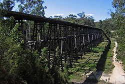
The East Gippsland Rail Trail itself continues east through the Colquhoun State Forest on a generally good surface at a gradual decline. A few kilometres on from the Discovery Trail turnoff is the site of the former Colquhoun railway station and siding]], which, at 129m is the highest point on the trail, however the site is rapidly being overgrown by forest. Further along, about 4.5 km west of Nowa Nowa
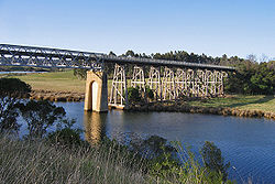
is the spectacular Stony Creek Trestle Bridge, built in the early 1900s and measuring 276m long and 19m high. Due to its poor condition the bridge itself is fenced off, and trail users must travel down and up the steep slopes of the Stony Creek valley to reach the far side. A carpark, toilet and picnic facilities are available at this location.
The trail continues to the small town of Nowa Nowa where it diverts through the town, departing from the former railway route. It runs onto an old section of the highway and down to the Lakes Entrance Road, where it then turns sharply onto a concrete path through the town. The path takes an underpass below the highway and leaves town after crossing a bridge over Boggy Creek, finally rejoining the original railway route beyond the east side of the town.
to Newmerella section was the last section of the track to open, being constructed in 2005 at a cost of $660,000 and opening in January 2006, with a further 2 km of shared pathway taking the trail into Orbost
.
The track leaves Nowa Nowa after crossing the bridge over Boggy Creek and soon rejoins the railway line formation. The former Nowa Nowa railway station is just north of the realigned rail trail, with the station site itself now used as an emergency helicopter landing place. Not far from town the track descends to a creek level crossing over Ironstone Creek, bypassing the first and smallest of three wooden trestle bridges in this section. Following this the track steadily climbs over several kilometres on a rough loose gravel surface through a gradually drier environment largely composed of banksia
and eucalypt
vegetation, and areas of open farmland, then descends towards Wairewa Road about 9km from Nowa Nowa. The original rail line crossed this spot on a spectacular curved timber trestle bridge, the largest of the three on this part of the route. While the bridge remains, the trail again bypasses it due to the costs that would be involved in making and keeping the bridge safe, descending down and across Wairewa Road, then climbing back up to the level of the railway.
Beyond this point the trail heads back towards the Princes Highway and then runs close to it for several kilometres. Near Johnsons Road the trail passes the unmarked site of the former Tostaree railway station and travels just north of the small locality of Tostaree, and then drops down to another low level creek crossing over Hospital Creek, bypassing the third of the former railway trestle bridges. The track climbs again and soon diverges from the highway, then travels through light forest and occasional farmland on a quite wide but rough surface, before reaching Partellis Crossing Road at about the midpoint of this section of the trail. There is a picnic table, seats, and toilet facilities at this location, however no water is available.
Continuing on from Partellis Crossing the trail continues for several kilometres through mixed forest and farmland, and then past the former timber mill
site of Waygara; native vegetation is reclaiming this site but some signs of the former mill are visible such as a shed, an incinerator
stack, and former mill houses. The former Waygara railway station was also in this location, however little sign remains of it. The trail again starts heading back towards the highway and soon crosses Simpsons Creek and then Simpsons Creek Rd through more forested areas which preserve a significant amount of biological diversity from early and pre-European settlement times.
Another 3 km on is the first crossing of Joiners Rd, and from this point to Newmeralla about 5 km distant the trail travels very closely to the Princes Highway with increasing signs of development such as timber mill operations and a pumping station
for the underground gas pipeline
. The trail crosses Prestons Road, which provides access to the small town of Newmerella, while the trail itself continues for another couple of kilometres, doglegging through a cutting around a steep hillside, then providing views over the Snowy River
floodplain
before descending to the end of the trail at Burn Rd, north of the Princes Highway
at Newmeralla.
Across the road from the end of the rail trail is an off-road shared pathway which was constructed in 2007/08 and which leads into Orbost, about another 2 km further on. The original Orbost terminus of the line was on the west bank of the Snowy River, with the train never actually crossing the river into Orbost
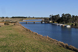
itself. The shared pathway travels near this station site, but little remains of it. There is however an impressive low level causeway over the river flats consisting of a series of timber and steel bridges called the Orbost Viaduct
, which shows the original route of the railway, however there are no plans to reopen this as part of the rail trail.
Rail trail
A rail trail is the conversion of a disused railway easement into a multi-use path, typically for walking, cycling and sometimes horse riding. The characteristics of former tracks—flat, long, frequently running through historical areas—are appealing for various development. The term sometimes also...
located in East Gippsland
East Gippsland
East Gippsland is the eastern region of Gippsland, Australia covering 31,740 square kilometres of Victoria. It has a population of 80,114....
in Victoria
Victoria (Australia)
Victoria is the second most populous state in Australia. Geographically the smallest mainland state, Victoria is bordered by New South Wales, South Australia, and Tasmania on Boundary Islet to the north, west and south respectively....
, Australia
Australia
Australia , officially the Commonwealth of Australia, is a country in the Southern Hemisphere comprising the mainland of the Australian continent, the island of Tasmania, and numerous smaller islands in the Indian and Pacific Oceans. It is the world's sixth-largest country by total area...
. The trail is a popular cycling
Cycling
Cycling, also called bicycling or biking, is the use of bicycles for transport, recreation, or for sport. Persons engaged in cycling are cyclists or bicyclists...
route, beginning in Bairnsdale and extending to Orbost
Orbost, Victoria
Orbost is a town in the Shire of East Gippsland, Victoria, Australia, located east of Melbourne and south of Canberra where the Princes Highway crosses the Snowy River. It is about from the town of Marlo on the coast of Bass Strait. At the 2006 census, Orbost had a population of 2452...
, following the route of the former Orbost railway line
Orbost railway line
The Orbost railway line is a railway serving the Latrobe Valley and Gippsland regions of Victoria, Australia...
. The shared trail is also available for walkers
Pedestrian
A pedestrian is a person traveling on foot, whether walking or running. In some communities, those traveling using roller skates or skateboards are also considered to be pedestrians. In modern times, the term mostly refers to someone walking on a road or footpath, but this was not the case...
and recreational horseriding
Equestrianism
Equestrianism more often known as riding, horseback riding or horse riding refers to the skill of riding, driving, or vaulting with horses...
, however motorised vehicles are prohibited.
The trail is 96 kilometres (59.7 mi) long and passes through a variety of forest and farmland landscapes with occasional views of the Gippsland Lakes
Gippsland Lakes
The Gippsland Lakes are a network of lakes, marshes and lagoons in east Gippsland, Victoria, Australia covering an area of about 600 km2. The largest of the lakes are Lake Wellington , Lake King and Lake Victoria. They are fed by the Avon, Thomson, Latrobe, Mitchell, Nicholson and Tambo...
. Parts of the trail are accessible to any bicycle
Bicycle
A bicycle, also known as a bike, pushbike or cycle, is a human-powered, pedal-driven, single-track vehicle, having two wheels attached to a frame, one behind the other. A person who rides a bicycle is called a cyclist, or bicyclist....
, but significant sections are suitable only for mountain bike
Mountain bike
A mountain bike or mountain bicycle is a bicycle created for off-road cycling. This activity includes traversing of rocks and washouts, and steep declines,...
s or sturdy hybrid bikes
Hybrid bicycle
A hybrid bicycle is a bicycle designed for general-purpose utility and commuting on a wide variety of surfaces, including paved and unpaved roads, paths and trails...
.
Route description
The East Gippsland Rail Trail travels from just east of the current Bairnsdale railway station along the old Orbost railway line easement, past or through the small towns of NicholsonNicholson, Victoria
Nicholson is a small town in East Gippsland, Victoria, Australia, 295 km east of the state capital Melbourne. It is situated between the larger towns of Bairnsdale and Lakes Entrance...
, Bruthen
Bruthen, Victoria
Bruthen is a small town located alongside the Tambo River between Bairnsdale and Ensay on the Great Alpine Road in East Gippsland, Victoria, Australia. At the 2006 census, Bruthen had a population of 624...
, Nowa Nowa
Nowa Nowa, Victoria
Nowa Nowa is a small town in the Australian state of Victoria. It is in East Gippsland, near Lakes Entrance. At the 2006 census, Nowa Nowa and the surrounding area had a population of 144....
, and Newmerella, with a short connecting path taking it into Orbost
Orbost, Victoria
Orbost is a town in the Shire of East Gippsland, Victoria, Australia, located east of Melbourne and south of Canberra where the Princes Highway crosses the Snowy River. It is about from the town of Marlo on the coast of Bass Strait. At the 2006 census, Orbost had a population of 2452...
. Water and most facilities are only available in these towns, so trail users are required to be self-sufficient. The trail follows the long gradual inclines and sweeping curves of the former railway line, reaching a maximum altitude of 129 m at Colquhoun.
Along its route it passes the former railway stations
Train station
A train station, also called a railroad station or railway station and often shortened to just station,"Station" is commonly understood to mean "train station" unless otherwise qualified. This is evident from dictionary entries e.g...
and/or sidings at Nicholson, Bumberrah, Mossiface, Bruthen, Colquhoun, Nowa Nowa, Tostaree, Waygara, and Orbost. It passes across or past a number of former railway bridges including some large trestle bridges, and starts alongside the Mitchell River
Mitchell River (Victoria)
The Mitchell River is the largest unregulated river in Victoria, Australia and provides a unique example of riparian ecology. Tributaries include the Crooked, Dargo, Wentworth, Wonnangatta, and Wongungarra Rivers, which are surrounded by dense native forest on the steep mountains of the Victorian...
and crosses the Nicholson River
Nicholson River (Victoria)
The Nicholson River is a river in East Gippsland, Victoria, Australia, lying between the Mitchell and the Tambo Rivers. It has a length of .The river was named by Angus McMillan in 1839 after Charles Nicholson, who represented the Port Phillip District on the NSW Legislative Council and was later...
, Tambo River
Tambo River (Victoria)
The Tambo River is a river in East Gippsland, Victoria, Australia with a total length in excess of 170 km. It is the longest river in the Tambo and Nicholson Basin, extending from the steep forested southern slopes of the Australian Alps through forest and farmland to the Gippsland...
and Snowy River
Snowy River
The Snowy River is a major river in south-eastern Australia. It originates on the slopes of Mount Kosciuszko, Australia's highest mainland peak, draining the eastern slopes of the Snowy Mountains in New South Wales, before flowing through the Snowy River National Park in Victoria and emptying into...
, as well as several minor watercourse
Watercourse
A watercourse is any flowing body of water. These include rivers, streams, anabranches, and so forth.-See also:* physical geography* Environmental flow* Waterway* Hydrology* Wadi-External links:...
s on its way to Orbost.
Bairnsdale to Nicholson (9 km)
The East Gippsland Rail Trail does not officially begin at the BairnsdaleBairnsdale, Victoria
Bairnsdale is a small city in Gippsland, Victoria, Australia. With a population at the 2006 census of 11,282, it is a major regional centre of eastern Victoria along with Traralgon and Sale....
railway station itself due to the poor condition of the old rail bridge over the Mitchell River
Mitchell River (Victoria)
The Mitchell River is the largest unregulated river in Victoria, Australia and provides a unique example of riparian ecology. Tributaries include the Crooked, Dargo, Wentworth, Wonnangatta, and Wongungarra Rivers, which are surrounded by dense native forest on the steep mountains of the Victorian...
. The trail begins on the south side of the Princes Highway
Princes Highway
The Princes Highway extends from Sydney to Port Augusta via the coast through the states of New South Wales, Victoria and South Australia, a distance of 1941 km or 1898 km via the former alignments of the highway ....
opposite the Howitt Park sports grounds at McEacharn Street.
The rail trail is accessible from the town via the road or footpath on the Princes Highway road bridge across the river. Toilet
Toilet
A toilet is a sanitation fixture used primarily for the disposal of human excrement, often found in a small room referred to as a toilet/bathroom/lavatory...
s and good car parking
Parking lot
A parking lot , also known as car lot, is a cleared area that is intended for parking vehicles. Usually, the term refers to a dedicated area that has been provided with a durable or semi-durable surface....
facilities are available in the main section of Howitt Park on the north side of Princes Highway. Safe access to the south side of the highway and the rail trail can be obtained by following the path alongside the Mitchell River under the road bridge and up to road level, then along between the highway and the Howitt Park sports grounds.
The trail travels east from Bairnsdale following the route of the old railway line and roughly follows the line of the Princes Highway. The trail initially passes between industrial and retail properties leading out of Bairnsdale, then travels mainly through open farmland, predominantly for cattle and horse grazing, to the town of Nicholson
Nicholson, Victoria
Nicholson is a small town in East Gippsland, Victoria, Australia, 295 km east of the state capital Melbourne. It is situated between the larger towns of Bairnsdale and Lakes Entrance...
.
There are distant views of the Gippsland Lakes
Gippsland Lakes
The Gippsland Lakes are a network of lakes, marshes and lagoons in east Gippsland, Victoria, Australia covering an area of about 600 km2. The largest of the lakes are Lake Wellington , Lake King and Lake Victoria. They are fed by the Avon, Thomson, Latrobe, Mitchell, Nicholson and Tambo...
in some sections, and a number of crossings of minor roads are required, as well an unsigned crossing of the Princes Highway. The surface is sealed with asphalt
Asphalt
Asphalt or , also known as bitumen, is a sticky, black and highly viscous liquid or semi-solid that is present in most crude petroleums and in some natural deposits, it is a substance classed as a pitch...
and is in fair to good condition as far as the Nicholson River
Nicholson River (Victoria)
The Nicholson River is a river in East Gippsland, Victoria, Australia, lying between the Mitchell and the Tambo Rivers. It has a length of .The river was named by Angus McMillan in 1839 after Charles Nicholson, who represented the Port Phillip District on the NSW Legislative Council and was later...
bridge in Nicholson, 9 km from the start of the route. The bridge is the former railway bridge across the river, now sealed with concrete, while just before the bridge is a station name board marking the site of the former Nicholson railway station.
The trail passes just to the north of the Nicholson
Nicholson, Victoria
Nicholson is a small town in East Gippsland, Victoria, Australia, 295 km east of the state capital Melbourne. It is situated between the larger towns of Bairnsdale and Lakes Entrance...
township. Access to the town itself can be gained either by turning south at the Nicolson-Sarsfield Road, or by following a minor track along the west side of the Nicholson River. Toilets, water and barbecue
Barbecue
Barbecue or barbeque , used chiefly in the United States, Canada, the United Kingdom, New Zealand and Australia is a method and apparatus for cooking meat, poultry and occasionally fish with the heat and hot smoke of a fire, smoking wood, or hot coals of...
facilities are available at the Nicholson boat ramp on the west bank of the river to the south of the Princes Highway.
 |
 |
 |
Nicholson to Bruthen (22 km)
The rail trail crosses the Nicholson River on the former railway bridge. The bridge surface has been sealed with concreteConcrete
Concrete is a composite construction material, composed of cement and other cementitious materials such as fly ash and slag cement, aggregate , water and chemical admixtures.The word concrete comes from the Latin word...
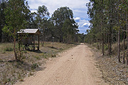
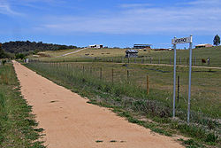
and affords excellent views. Beyond the bridge the track surface becomes smooth gravel and heads inland away from the Princes Highway. The trail passes through undulating farmland, veering from its easterly route to northerly direction on a gradually rougher track surface, and after 9 km reaches the old Bumberrah railway station where there is a rest stop with a shelter and information board in a remnant grassy woodland reserve.
From Bumberrah the trail travels 8.5 km on to Mossiface, passing through various cuttings, fills
Fill dirt
Fill dirt is earthy material which is used to fill in a depression or hole in the ground or create mounds or otherwise artificially change the grade or elevation of real property....
and tunnel
Tunnel
A tunnel is an underground passageway, completely enclosed except for openings for egress, commonly at each end.A tunnel may be for foot or vehicular road traffic, for rail traffic, or for a canal. Some tunnels are aqueducts to supply water for consumption or for hydroelectric stations or are sewers...
s from the old rail route. The surface is rough gravel and of poor standard through much of this section, including occasional wombat
Wombat
Wombats are Australian marsupials; they are short-legged, muscular quadrupeds, approximately in length with a short, stubby tail. They are adaptable in their habitat tolerances, and are found in forested, mountainous, and heathland areas of south-eastern Australia, including Tasmania, as well as...
holes, but there is significant flora and fauna, as well as some good views of adjacent farmland and hills. Mossiface, a tiny locality of only a few houses and facilities, was the site of the former Mossiface railway station and offers views of the Tambo River
Tambo River (Victoria)
The Tambo River is a river in East Gippsland, Victoria, Australia with a total length in excess of 170 km. It is the longest river in the Tambo and Nicholson Basin, extending from the steep forested southern slopes of the Australian Alps through forest and farmland to the Gippsland...
flats and historic hop kilns
Oast house
An oast, oast house or hop kiln is a building designed for kilning hops as part of the brewing process. They can be found in most hop-growing areas and are often good examples of vernacular architecture...
of the region.
Following Mossiface the trail continues north for about 2.5 km on a smooth gravel surface and crosses the Great Alpine Road
Great Alpine Road
The Great Alpine Road is a country tourist road in Victoria, Australia, running from Wangaratta in the north to Bairnsdale in the east, and passing through the Australian Alps...
at the site of a former railway trestle bridge which used to take the railway over the highway. Just past the trestle bridge, 2 km out of Bruthen
Bruthen, Victoria
Bruthen is a small town located alongside the Tambo River between Bairnsdale and Ensay on the Great Alpine Road in East Gippsland, Victoria, Australia. At the 2006 census, Bruthen had a population of 624...
, the track diverges, with one route (the Bruthen-Wiseleigh path) travelling alongside the Great Alpine Road directly into Bruthen, while the rail trail proper continues to follow the route of the old railway about 100m north of the road.
About half a kilometre before the town the remains of the former Bruthen railway station can clearly be seen on the rail trail. Shortly past the station site a minor detour from the trail can be taken in order to enter Bruthen itself, the largest town en route, where major facilities such as food, drink, toilets and accommodation are available.
 |
 |
 |
Bruthen to Nowa Nowa (27 km)
The rail trail continues from the Bruthen Station site and passes below the Great Alpine Road through the former railway tunnel. It then skirts around the southern edge of Bruthen following the route of the railway line. The trail goes over the Storer Bridge, a former railway bridge over the Tambo RiverTambo River (Victoria)
The Tambo River is a river in East Gippsland, Victoria, Australia with a total length in excess of 170 km. It is the longest river in the Tambo and Nicholson Basin, extending from the steep forested southern slopes of the Australian Alps through forest and farmland to the Gippsland...
now sealed with boards as the trail surface, and then passes behind the sports ground at the eastern edge of the town, where an alternative detour into Bruthen can be accessed.
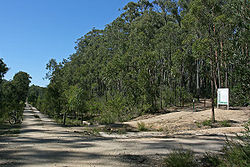
After leaving Bruthen the trail passes through some grazing land on a smooth gravel surface, then enters an open eucalyptus
Eucalyptus
Eucalyptus is a diverse genus of flowering trees in the myrtle family, Myrtaceae. Members of the genus dominate the tree flora of Australia...
forest
Forest
A forest, also referred to as a wood or the woods, is an area with a high density of trees. As with cities, depending where you are in the world, what is considered a forest may vary significantly in size and have various classification according to how and what of the forest is composed...
, the Colquhoun State Forest, where it climbs steadily for several kilometres on a stony gravel surface suffering from a fair degree of washboarding
Washboarding
Washboarding is the name of the process which results in unmetalled roads developing a series of regular bumps with short spacing in the road surface...
, along with some sandy sections. At Seaton Track in the Colquhoun Forest, 11 km out of Bruthen, the Gippsland Lakes Discovery Trail
Gippsland Lakes Discovery Trail
The Gippsland Lakes Discovery Trail is a 25 km rail trail in East Gippsland, Victoria, Australia, sometimes known as the Mississippi Creek Trail....
provides a connection to Lakes Entrance
Lakes Entrance, Victoria
Lakes Entrance is a tourist resort and fishing port in eastern Victoria, Australia. It is situated approximately east of Melbourne, near a managed, man-made channel connecting the Gippsland Lakes to the Bass Strait. At the 2006 census, Lakes Entrance had a population of 4,094.The township was...
, approximately 25 km to the south.
The East Gippsland Rail Trail itself continues east through the Colquhoun State Forest on a generally good surface at a gradual decline. A few kilometres on from the Discovery Trail turnoff is the site of the former Colquhoun railway station and siding]], which, at 129m is the highest point on the trail, however the site is rapidly being overgrown by forest. Further along, about 4.5 km west of Nowa Nowa
Nowa Nowa, Victoria
Nowa Nowa is a small town in the Australian state of Victoria. It is in East Gippsland, near Lakes Entrance. At the 2006 census, Nowa Nowa and the surrounding area had a population of 144....
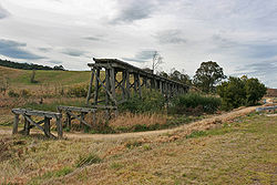
is the spectacular Stony Creek Trestle Bridge, built in the early 1900s and measuring 276m long and 19m high. Due to its poor condition the bridge itself is fenced off, and trail users must travel down and up the steep slopes of the Stony Creek valley to reach the far side. A carpark, toilet and picnic facilities are available at this location.
The trail continues to the small town of Nowa Nowa where it diverts through the town, departing from the former railway route. It runs onto an old section of the highway and down to the Lakes Entrance Road, where it then turns sharply onto a concrete path through the town. The path takes an underpass below the highway and leaves town after crossing a bridge over Boggy Creek, finally rejoining the original railway route beyond the east side of the town.
 |
 |
 |
Nowa Nowa to Orbost (38 km)
The 36 km Nowa NowaNowa Nowa, Victoria
Nowa Nowa is a small town in the Australian state of Victoria. It is in East Gippsland, near Lakes Entrance. At the 2006 census, Nowa Nowa and the surrounding area had a population of 144....
to Newmerella section was the last section of the track to open, being constructed in 2005 at a cost of $660,000 and opening in January 2006, with a further 2 km of shared pathway taking the trail into Orbost
Orbost, Victoria
Orbost is a town in the Shire of East Gippsland, Victoria, Australia, located east of Melbourne and south of Canberra where the Princes Highway crosses the Snowy River. It is about from the town of Marlo on the coast of Bass Strait. At the 2006 census, Orbost had a population of 2452...
.
The track leaves Nowa Nowa after crossing the bridge over Boggy Creek and soon rejoins the railway line formation. The former Nowa Nowa railway station is just north of the realigned rail trail, with the station site itself now used as an emergency helicopter landing place. Not far from town the track descends to a creek level crossing over Ironstone Creek, bypassing the first and smallest of three wooden trestle bridges in this section. Following this the track steadily climbs over several kilometres on a rough loose gravel surface through a gradually drier environment largely composed of banksia
Banksia
Banksia is a genus of around 170 species in the plant family Proteaceae. These Australian wildflowers and popular garden plants are easily recognised by their characteristic flower spikes and fruiting "cones" and heads. When it comes to size, banksias range from prostrate woody shrubs to trees up...
and eucalypt
Eucalypt
Eucalypts are woody plants belonging to three closely related genera:Eucalyptus, Corymbia and Angophora.In 1995 new evidence, largely genetic, indicated that some prominent Eucalyptus species were actually more closely related to Angophora than to the other eucalypts; they were split off into the...
vegetation, and areas of open farmland, then descends towards Wairewa Road about 9km from Nowa Nowa. The original rail line crossed this spot on a spectacular curved timber trestle bridge, the largest of the three on this part of the route. While the bridge remains, the trail again bypasses it due to the costs that would be involved in making and keeping the bridge safe, descending down and across Wairewa Road, then climbing back up to the level of the railway.
Beyond this point the trail heads back towards the Princes Highway and then runs close to it for several kilometres. Near Johnsons Road the trail passes the unmarked site of the former Tostaree railway station and travels just north of the small locality of Tostaree, and then drops down to another low level creek crossing over Hospital Creek, bypassing the third of the former railway trestle bridges. The track climbs again and soon diverges from the highway, then travels through light forest and occasional farmland on a quite wide but rough surface, before reaching Partellis Crossing Road at about the midpoint of this section of the trail. There is a picnic table, seats, and toilet facilities at this location, however no water is available.
Continuing on from Partellis Crossing the trail continues for several kilometres through mixed forest and farmland, and then past the former timber mill
Sawmill
A sawmill is a facility where logs are cut into boards.-Sawmill process:A sawmill's basic operation is much like those of hundreds of years ago; a log enters on one end and dimensional lumber exits on the other end....
site of Waygara; native vegetation is reclaiming this site but some signs of the former mill are visible such as a shed, an incinerator
Incineration
Incineration is a waste treatment process that involves the combustion of organic substances contained in waste materials. Incineration and other high temperature waste treatment systems are described as "thermal treatment". Incineration of waste materials converts the waste into ash, flue gas, and...
stack, and former mill houses. The former Waygara railway station was also in this location, however little sign remains of it. The trail again starts heading back towards the highway and soon crosses Simpsons Creek and then Simpsons Creek Rd through more forested areas which preserve a significant amount of biological diversity from early and pre-European settlement times.
Another 3 km on is the first crossing of Joiners Rd, and from this point to Newmeralla about 5 km distant the trail travels very closely to the Princes Highway with increasing signs of development such as timber mill operations and a pumping station
Pumping station
Pumping stations are facilities including pumps and equipment for pumping fluids from one place to another. They are used for a variety of infrastructure systems, such as the supply of water to canals, the drainage of low-lying land, and the removal of sewage to processing sites.A pumping station...
for the underground gas pipeline
Pipeline transport
Pipeline transport is the transportation of goods through a pipe. Most commonly, liquids and gases are sent, but pneumatic tubes that transport solid capsules using compressed air are also used....
. The trail crosses Prestons Road, which provides access to the small town of Newmerella, while the trail itself continues for another couple of kilometres, doglegging through a cutting around a steep hillside, then providing views over the Snowy River
Snowy River
The Snowy River is a major river in south-eastern Australia. It originates on the slopes of Mount Kosciuszko, Australia's highest mainland peak, draining the eastern slopes of the Snowy Mountains in New South Wales, before flowing through the Snowy River National Park in Victoria and emptying into...
floodplain
Floodplain
A floodplain, or flood plain, is a flat or nearly flat land adjacent a stream or river that stretches from the banks of its channel to the base of the enclosing valley walls and experiences flooding during periods of high discharge...
before descending to the end of the trail at Burn Rd, north of the Princes Highway
Princes Highway
The Princes Highway extends from Sydney to Port Augusta via the coast through the states of New South Wales, Victoria and South Australia, a distance of 1941 km or 1898 km via the former alignments of the highway ....
at Newmeralla.
Across the road from the end of the rail trail is an off-road shared pathway which was constructed in 2007/08 and which leads into Orbost, about another 2 km further on. The original Orbost terminus of the line was on the west bank of the Snowy River, with the train never actually crossing the river into Orbost
Orbost, Victoria
Orbost is a town in the Shire of East Gippsland, Victoria, Australia, located east of Melbourne and south of Canberra where the Princes Highway crosses the Snowy River. It is about from the town of Marlo on the coast of Bass Strait. At the 2006 census, Orbost had a population of 2452...
itself. The shared pathway travels near this station site, but little remains of it. There is however an impressive low level causeway over the river flats consisting of a series of timber and steel bridges called the Orbost Viaduct
Viaduct
A viaduct is a bridge composed of several small spans. The term viaduct is derived from the Latin via for road and ducere to lead something. However, the Ancient Romans did not use that term per se; it is a modern derivation from an analogy with aqueduct. Like the Roman aqueducts, many early...
, which shows the original route of the railway, however there are no plans to reopen this as part of the rail trail.