
Snowy River
Encyclopedia
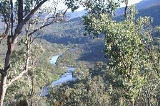
The Snowy River is a major river in south-eastern Australia
. It originates on the slopes of Mount Kosciuszko
, Australia's highest mainland peak, draining the eastern slopes of the Snowy Mountains
in New South Wales
, before flowing through the Snowy River National Park in Victoria
and emptying into Bass Strait
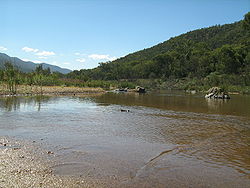
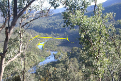
. Up until the mid–20th century, the river was notable for its high volume of fresh water, wide reach and large rapids.
While the river's course and surroundings have remained almost entirely unchanged, the majority of it being protected by the Snowy River National Park
, its flow was drastically reduced in the mid 20th century, to less than 1% (as measured at Jindabyne), after the construction of four large dams (Guthega, Island Bend, Eucumbene, and Jindabyne) and many smaller diversion structures in its headwaters in New South Wales, as part of the Snowy Mountains Scheme
.
 The main headwaters of the Snowy River, which include the Eucumbene
, Gungarlin and Thredbo River
s and many smaller alpine watercourses, are predominately located in Kosciuszko National Park
and meet near Jindabyne
. From this point the river winds 352 km southwards through inaccessible country, comprising private lands and the Snowy River National Park, eventually reaching the sea in the Snowy Inlet, at Marlo
, near Orbost
, Victoria
.
In New South Wales, the river runs through the Snowy River Shire. The tributaries of the Snowy River below Jindabyne include: the Mowamba, Wullwye Creek, Maclaughlin, Delegate
, Jacobs, Pinch, Suggan Buggan, Deddick, Buchan, Rodger and Brodribb Rivers.
In 1986, Jennings and Mabbutt mapped four geomorphic classes in the Snowy River Basin; (i) Australian Alps; (ii) the Monaro Tablelands; (iii) the East Victorian Uplands and (iv) the Gippsland Plains. Each class is physically distinct from one another, and they are further described by Erskine et al. (1999).
. There is a strong rainfall gradient across the catchment.
The highest average annual rainfall is recorded in the higher alpine reaches of the Snowy Catchment, with 1800 mm recorded in areas above 1500 m. The lowest average rainfall is recorded in the rain shadow affected north eastern catchment on the Monaro Plains around Dalgety, with average rain below 500 mm.
The lower eastern sub-catchments are more strongly influenced by coastal rainfall patterns. For example, peak rainfall in the Delegete catchment is strongly influenced by east coast lows, rather than the alpine dominated precipitation patterns in the upper Snowy River catchment.
These local variations in rainfall result in distinctly different hydrology in the rivers across the Snowy River catchment.
Typically, many Australian rivers can be defined as having highly variable river flows. The mixed snow melt-rainfall rivers of the Snowy Mountains can be defined by strong seasonal patterns but still contain a variable stream flow attributable to rainfall events across the catchment.
In the lower reaches of the Snowy River catchment, the larger tributaries have a distinctly different flow regime to the snow melt rivers of the alps. These tributaries are typically dominated by the winter rainfall and often have peak monthly flows a few months earlier than the snow melt tributaries. The peak monthly flows for these lower Snowy River tributaries occur in June through July. Additionally, the flow regime in the lower tributaries is far more variable and unpredictable.
 The Snowy River below Jindabyne Dam contains four major waterfalls. These are Stone Bridge Falls, Corrowong Falls, Snowy Falls and Pinch Falls. Potentially, many of these waterfalls act as barriers for the large scale movement of aquatic species in the main stem
of the Snowy River. The flows required to drown out the largest barrier, Snowy Falls, is potentially larger than the environmental water releases to the river via Jindabyne Dam.
The bushfires of 2002-03, added to this problem as large amounts of sediment and organic matter were deposited in the river via tributary inflows. This input of sediment lead to the substrate becoming finer. This pattern of increased silt in the pools of rivers and streams has been observed across the Snowy Mountains following the bushfires. These bushfires are likely to have a long lasting influence on these waterways.
Larger events are required to start to improve the condition of the river bed. Events of 1,000 ML/day will start to move the unconsolidated fine particles of the riverbed. Events between 1,000 and 3,000 ML/day are important for conditioning the riffle habitats (i.e., a type of flowing water habitat).
The current poor condition of the river bed is one of the key factors inhibiting the aquatic fauna typical in a snow melt river.
Large dams can essentially influence downstream water quality via two key mechanisms, either by poor water quality released from the waters of the dam itself and reduced mixing of the river water column attributable to lower water velocities leading to anoxic conditions at the bottom of deep river pools.
The Snowy River is on average 4oC warmer than the surrounding unregulated snow melt rivers, with a peak difference of up to 8oC. The water temperature in spring appears to be the greatly warmer than the surrounding snow melt rivers.
Stratification can occur between October and March, but typically does not persist for very long in the Snowy River in the Jindabyne Gorge. Breakdown of thermal stratification is frequently driven by the cooling overnight air temperature. This region experiences a very large temperature range between day and night (i.e. diurnal temperature range).
, whereas the riverbed algae is defined as periphyton
(attached algae).
The composition of algae in the free flowing snow melt rivers are typically defined by diatoms. Over 58% of taxa are diatoms, with Fragilaria spp. being the most numerically abundant taxa.
Caenid mayflies (riffles) and oligochaete worms (pool edges) are generally typical of the upland regulated Snowy River. Other studies have also found greater densities of Caenidae mayflies in regulated rivers compared to unregulated rivers. Reduced high flows and constant low flows in the upper Snowy River are likely to have favoured high densities of worms through the build up of silt and organic matter in the pools. Nichols et al. (2006) and Petts et al. (1993) also found greater densities of segmented worms associated with soft sediments and coarse organic debris in response to river regulation. Chironomids were also numerically dominant in riffles sampled in the regulated Snowy River. This response has been found in many other studies of regulated rivers and has been attributed to an increase of periphytic growth in riffles that increased overall habitat area and food availability.
Conoesucidae caddisflies (riffles), larval and adult elimids (riffles) and Oniscigastridae (pool edges) distinguished the snow melt rivers from regulated Snowy River. Marchant and Hehir (2002) reported that AUSRIVAS models (>50% probability) predicted Conoesucidae and elmids to be present in the upper Snowy River, but these taxa were not found in their study. The greater density of these taxa in snowmelt rivers compared the Snowy River is consistent with river regulation.
Marchant and Hehir attribute the absence of these taxa to dams acting as a barrier to drift and limiting recolonisation of these taxa and not to flow regulation. The upper Snowy River sites are all below the confluence of the Mowamba River which provides a pathway for recolonisation of the Snowy River. Therefore, the reduced flow and altered flow regime is likely to be the primary cause of reduced densities of these taxa in the upper Snowy River rather than the barrier effects of Jindabyne Dam. There is little information on the responses of Oniscigastridae to reduced flows and altered flow regimes, but it is probable that an elevated temperature regime combined with lack of suitable sandy edge habitat has reduced their densities in the Snowy River.
The major differences between the two zones were the low abundance or absence of diadromous migratory fish (except eels) and the greater abundance of short-finned eel and trout in the upper catchment, and the greater abundance of Australian smelt
, congoli and long-finned eel
below Snowy Falls. These upper and lower Snowy River zone differences were greater than the differences between un-regulated tributary streams and the highly regulated main channel of the Snowy River within either zone. In the upper catchment, river blackfish, brown trout and short-finned eel were more abundant in un-regulated tributaries, whilst long-finned eel and goldfish were more abundant in the regulated upper part of the Snowy River. In the lower zone, eastern gambusia, long-finned eel, Australian smelt, short-finned eel and congoli were all more abundant in Snowy River while common galaxias and short-headed lamprey were more abundant at tributaries.
Further defining of ecological flow thresholds is currently in progress via modelling, field based studies, and flow trials. See Snowy Flow Response Monitoring and Modelling.
as a food and water resource by Indigenous Australians
for around 30,000–40,000 years prior to European settlement. Evidence of human occupation at Cloggs Cave, near the Snowy River, near Buchan
, was dated at up to 17,000 years. Despite the cold climate in the river's higher reaches, the Ngarigo
nation held territory around the Australian Alps
and the Snowy Mountains
in modern day New South Wales. As the river flowed southwards into modern day Victoria, it flowed in the Gunai
nation's territory, particularly, the Krauatungalung
clan's territory.
and Murrumbidgee River
agricultural basins for irrigation
. Several hydro-electric power stations were also constructed to generate electricity
. While there was initial public opposition to the diversion of the river's water during the 1950s and '60s, it was largely ignored as the scheme provided agriculture with more water and generated a large amount of jobs at the time.
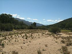
, New South Wales and across Australia. After the scheme was built downstream flows were insufficient to keep the channel clear of vegetation or move sediment in the stream bed
. Salt water intrusion extended seven to ten kilometres up the estuary and outdoor recreational activities were curtailed along the lower reaches of the river.
This period of increased awareness of the impacts of water diversions lead to the Snowy Water Inquiry, which looked at options to improve the health of the Snowy River. The key outcomes of the Snowy Water Inquiry was an initial agreement to increase environmental water releases to the Snowy River below Jindabyne by 15% and the Snowy Montane Rivers.
These series of staged flow targets (up to 28% of mean annual natural discharge) were set for the Snowy River below Jindabyne, with these dependent on water savings in the Murray and Murrumbidgee River catchments. The targets included 15% by 2009 and 21% by 2012.
This stage increased flows from 1% to approximately 4% of mean annual river discharge. Typically an annual release of 38 GL/year.
Overall the annual volume released remained around 38GL year given the historical record drought.
During this period the annual water availability jumped from about 38 GL/Year to about 150 GL/Year.
Although water is released all year, this period has seen two significant spring snow melt environmental water releases to the Snowy River.
In November 2010 the first spring snow melt release occurred. This small but important release had a peak discharge of 3,080 megalitres per day, and was sufficient to start to scour the fines sediment from some sections of the bed of the Snowy.
In October 2011, with substantially greater water available a much larger spring snow melt release has occurred i.e. 84 GL over 19 days. This second and substaitially larger release with a peak discharge rate of 12,000 megalitres per day over three days is expected to scour the bed of the river. This releases targeted much larger particles, up to the size of 256mm, as the bed of the river is heavily "armoured" and larger flows are required to move these particles to improve the instream habitat of the river. Once the armouring had been removed it is expected the fine sediment would be scoured within the river bed profile.
, was elected to the Victorian Legislative Assembly
in 1999 and re-elected in 2002 and 2006, on a platform to increase the flow of water in the Snowy River.
After Ingram was elected to office, rather than attempt to increase water-flow, he became instrumental in the corporatisation of the Snowy Scheme, swinging the Victorian Government to sign the legislation. Although the Victorian, NSW and Federal governments promised that corporatisation would not lead to privatisation, in November 2005 they announced their intention to sell Snowy Hydro
through a public float. Community groups rallied to stop the sale of Snowy Hydro and by June 2006 the Australian Prime Minister withdrew the Commonwealth's intention to sell Snowy Hydro.
in 1890, which formed the basis of many subsequent works in film
, TV and music theatre.
The natural environment surrounding the Snowy River formed part of the subject matter and setting for the 'Banjo' Paterson
poem The Man from Snowy River, first published in 1890. The Snowy River has also been immortalised in a 1920 The Man from Snowy River
silent film, as well as in the better-known 1982 Fox
film The Man from Snowy River and its 1988 Disney
sequel film The Man from Snowy River II (U.S. title: "Return to Snowy River" — UK title: "The Untamed"), as well as in the The Man from Snowy River (TV series)
and The Man from Snowy River: Arena Spectacular
, all of which were based on the Banjo Paterson's poem.
New South Wales:
Victoria:
Victoria:
Australia
Australia , officially the Commonwealth of Australia, is a country in the Southern Hemisphere comprising the mainland of the Australian continent, the island of Tasmania, and numerous smaller islands in the Indian and Pacific Oceans. It is the world's sixth-largest country by total area...
. It originates on the slopes of Mount Kosciuszko
Mount Kosciuszko
Mount Kosciuszko is a mountain located in the Snowy Mountains in Kosciuszko National Park. With a height of 2,228 metres above sea level, it is the highest mountain in Australia...
, Australia's highest mainland peak, draining the eastern slopes of the Snowy Mountains
Snowy Mountains
The Snowy Mountains, known informally as "The Snowies", are the highest Australian mountain range and contain the Australian mainland's highest mountain, Mount Kosciuszko, which reaches 2,228 metres AHD, approximately 7310 feet....
in New South Wales
New South Wales
New South Wales is a state of :Australia, located in the east of the country. It is bordered by Queensland, Victoria and South Australia to the north, south and west respectively. To the east, the state is bordered by the Tasman Sea, which forms part of the Pacific Ocean. New South Wales...
, before flowing through the Snowy River National Park in Victoria
Victoria (Australia)
Victoria is the second most populous state in Australia. Geographically the smallest mainland state, Victoria is bordered by New South Wales, South Australia, and Tasmania on Boundary Islet to the north, west and south respectively....
and emptying into Bass Strait
Bass Strait
Bass Strait is a sea strait separating Tasmania from the south of the Australian mainland, specifically the state of Victoria.-Extent:The International Hydrographic Organization defines the limits of the Bass Strait as follows:...
. Up until the mid–20th century, the river was notable for its high volume of fresh water, wide reach and large rapids.
While the river's course and surroundings have remained almost entirely unchanged, the majority of it being protected by the Snowy River National Park
Snowy River National Park
Snowy River is a national park in Victoria , 323 km east of Melbourne.Much of the park is classified as wilderness area, where vehicles are unable to visit. The park provides one of the last natural habitats at the Little River Gorge for the endangered brush-tailed rock wallaby...
, its flow was drastically reduced in the mid 20th century, to less than 1% (as measured at Jindabyne), after the construction of four large dams (Guthega, Island Bend, Eucumbene, and Jindabyne) and many smaller diversion structures in its headwaters in New South Wales, as part of the Snowy Mountains Scheme
Snowy Mountains Scheme
The Snowy Mountains scheme is a hydroelectricity and irrigation complex in south-east Australia. It consists of sixteen major dams; seven power stations; a pumping station; and 225 kilometres of tunnels, pipelines and aqueducts and was constructed between 1949 and 1974. The Chief engineer was Sir...
.
Geography
Eucumbene River
The Eucumbene River rises in the northern part of the Kosciuszko National Park in the Snowy Mountains of New South Wales, Australia, and flows south. Its flow is blocked by Eucumbene Dam, the largest dam in the Snowy Mountains Scheme...
, Gungarlin and Thredbo River
Thredbo River
The Thredbo is a river which runs through Thredbo, New South Wales, Australia. Formerly known as the Crackenback River. Feeds into the Snowy River at Lake Jindabyne....
s and many smaller alpine watercourses, are predominately located in Kosciuszko National Park
Kosciuszko National Park
Kosciuszko National Park covers 690,000 hectares and contains mainland Australia's highest peak, Mount Kosciuszko for which it is named, and Cabramurra the highest town in Australia...
and meet near Jindabyne
Jindabyne, New South Wales
Jindabyne is a town in south-east New South Wales, Australia that overlooks Lake Jindabyne near the Snowy Mountains, in Snowy River Shire. It is a popular holiday destination, especially in winter, due to its proximity to several ski resorts throughout the Kosciuszko National Park, including...
. From this point the river winds 352 km southwards through inaccessible country, comprising private lands and the Snowy River National Park, eventually reaching the sea in the Snowy Inlet, at Marlo
Marlo, Victoria
Marlo is a small village in the Gippsland region of Victoria, Australia. It is located east near the mouth of the Snowy River where the Snowy River meets and flows into the Southern Ocean....
, near Orbost
Orbost, Victoria
Orbost is a town in the Shire of East Gippsland, Victoria, Australia, located east of Melbourne and south of Canberra where the Princes Highway crosses the Snowy River. It is about from the town of Marlo on the coast of Bass Strait. At the 2006 census, Orbost had a population of 2452...
, Victoria
Victoria (Australia)
Victoria is the second most populous state in Australia. Geographically the smallest mainland state, Victoria is bordered by New South Wales, South Australia, and Tasmania on Boundary Islet to the north, west and south respectively....
.
In New South Wales, the river runs through the Snowy River Shire. The tributaries of the Snowy River below Jindabyne include: the Mowamba, Wullwye Creek, Maclaughlin, Delegate
Delegate River
The Delegate River is a river in the states of Victoria andNew South Wales, Australia. It is a tributary of the Snowy River.It rises on the northern slopes of the Errinundra Plateau in east Gippsland, Victoria and flows north into New South Wales to join the Snowy Rivernear Delegate....
, Jacobs, Pinch, Suggan Buggan, Deddick, Buchan, Rodger and Brodribb Rivers.
In 1986, Jennings and Mabbutt mapped four geomorphic classes in the Snowy River Basin; (i) Australian Alps; (ii) the Monaro Tablelands; (iii) the East Victorian Uplands and (iv) the Gippsland Plains. Each class is physically distinct from one another, and they are further described by Erskine et al. (1999).
Rainfall
The general distribution of rainfall over the Snowy River catchment is controlled by orographic effectsOrography
Orography is the study of the formation and relief of mountains, and can more broadly include hills, and any part of a region's elevated terrain...
. There is a strong rainfall gradient across the catchment.
The highest average annual rainfall is recorded in the higher alpine reaches of the Snowy Catchment, with 1800 mm recorded in areas above 1500 m. The lowest average rainfall is recorded in the rain shadow affected north eastern catchment on the Monaro Plains around Dalgety, with average rain below 500 mm.
The lower eastern sub-catchments are more strongly influenced by coastal rainfall patterns. For example, peak rainfall in the Delegete catchment is strongly influenced by east coast lows, rather than the alpine dominated precipitation patterns in the upper Snowy River catchment.
These local variations in rainfall result in distinctly different hydrology in the rivers across the Snowy River catchment.
Hydrology
The snow melt derived rivers in the Snowy Mountains typically have the lowest average stream flow in the months from November to June, with October having the largest monthly flows of the year, e.g., mean monthly flow for October at Dalgety was 283,973 ML prior to the Snowy Scheme). The large flows in September and October are derived from snowmelt and hydrologically its one of the key aspects that defines these mountain waterways. Additionally the prolonged base flows over the summer months are another feature of these types of rivers. These prolonged base flows are driven by snowmelt derived groundwater.Typically, many Australian rivers can be defined as having highly variable river flows. The mixed snow melt-rainfall rivers of the Snowy Mountains can be defined by strong seasonal patterns but still contain a variable stream flow attributable to rainfall events across the catchment.
In the lower reaches of the Snowy River catchment, the larger tributaries have a distinctly different flow regime to the snow melt rivers of the alps. These tributaries are typically dominated by the winter rainfall and often have peak monthly flows a few months earlier than the snow melt tributaries. The peak monthly flows for these lower Snowy River tributaries occur in June through July. Additionally, the flow regime in the lower tributaries is far more variable and unpredictable.
Waterfalls
Main Stem
"Main Stem" is 1942 instrumental by Duke Ellington and His Famous Orchestra. Although recorded in 1942, the single would not be released until 1944 where it was Duke Ellington's last of four number one's on the Harlem Hit Parade. "Main Stem" would also peak at number twenty on the pop chart"Main...
of the Snowy River. The flows required to drown out the largest barrier, Snowy Falls, is potentially larger than the environmental water releases to the river via Jindabyne Dam.
Parklands and protected areas
Around 70–80% of the Snowy River's length is protected by national parks, these include, from upstream to downstream:- Kosciuszko National ParkKosciuszko National ParkKosciuszko National Park covers 690,000 hectares and contains mainland Australia's highest peak, Mount Kosciuszko for which it is named, and Cabramurra the highest town in Australia...
— New South Wales - Alpine National ParkAlpine National ParkThe Alpine National Park is a national park in Victoria , northeast of Melbourne. It covers much of the higher areas of the Great Dividing Range in Victoria, including Victoria's highest point, Mount Bogong and the associated subalpine woodland and grassland of the Bogong High Plains...
— Victoria - Snowy River National ParkSnowy River National ParkSnowy River is a national park in Victoria , 323 km east of Melbourne.Much of the park is classified as wilderness area, where vehicles are unable to visit. The park provides one of the last natural habitats at the Little River Gorge for the endangered brush-tailed rock wallaby...
— Victoria
River ecology
The aquatic flora and fauna of the snowy mountain snow melt rivers have evolved with the predictable seasonal hydrological snow melt peaks and constant summer base flow conditions. Many of these flora and fauna are coldwater specialists.River habitat
The instream habitat of the Snowy River below Jindabyne can be best described as highly disturbed. Many of the in-stream features of a large upland river are not evident today. The substrate was previously typified by a clean cobble stone substrate. Today, the river channel has contracted and the substrate has a heavy cover of sediment, overlaying much of the cobble stone riverbed.The bushfires of 2002-03, added to this problem as large amounts of sediment and organic matter were deposited in the river via tributary inflows. This input of sediment lead to the substrate becoming finer. This pattern of increased silt in the pools of rivers and streams has been observed across the Snowy Mountains following the bushfires. These bushfires are likely to have a long lasting influence on these waterways.
Larger events are required to start to improve the condition of the river bed. Events of 1,000 ML/day will start to move the unconsolidated fine particles of the riverbed. Events between 1,000 and 3,000 ML/day are important for conditioning the riffle habitats (i.e., a type of flowing water habitat).
The current poor condition of the river bed is one of the key factors inhibiting the aquatic fauna typical in a snow melt river.
Water quality
The mountain streams and rivers are typically low in nutrients and electrical conductivity. Electrical conductivity is generally below 50 µS/cm.Large dams can essentially influence downstream water quality via two key mechanisms, either by poor water quality released from the waters of the dam itself and reduced mixing of the river water column attributable to lower water velocities leading to anoxic conditions at the bottom of deep river pools.
Influence of Jindabyne Dam on water quality
Possibly the main influence on downstream water quality from Jindabyne Dam, is the influence on water temperature. Unlike many other dams were coldwater pollution is a concern, where water is released from the below the thermocline in the reservoir (i.e. the bottom water of the lake), the water is released from the surface waters of lake Jindabyne. The water temperature of the Snowy River downstream of Jindabyne often differs from the surrounding snowmelt rivers of Thredbo and Mowamba.The Snowy River is on average 4oC warmer than the surrounding unregulated snow melt rivers, with a peak difference of up to 8oC. The water temperature in spring appears to be the greatly warmer than the surrounding snow melt rivers.
Flow and thermal stratification in the Snowy
Thermal stratification in the river reaches below Jindabyne is typically restricted to a few of the larger or deeper pools. In general thermal stratification is spatially restricted to the pools that are typically greater than 4–5 m deep. Pools shallower than 4 m have not displayed any thermal stratification.Stratification can occur between October and March, but typically does not persist for very long in the Snowy River in the Jindabyne Gorge. Breakdown of thermal stratification is frequently driven by the cooling overnight air temperature. This region experiences a very large temperature range between day and night (i.e. diurnal temperature range).
Algae
Algae is present in the water column and on the bed of the Snowy River. The water column algae is called phytoplanktonPhytoplankton
Phytoplankton are the autotrophic component of the plankton community. The name comes from the Greek words φυτόν , meaning "plant", and πλαγκτός , meaning "wanderer" or "drifter". Most phytoplankton are too small to be individually seen with the unaided eye...
, whereas the riverbed algae is defined as periphyton
Periphyton
Periphyton are a complex mixture of algae, cyanobacteria, heterotrophic microbes, and detritus that are attached to submerged surfaces in most aquatic ecosystems. It serves as an important food source for invertebrates, tadpoles, and some fish. It can also absorb contaminants; removing them from...
(attached algae).
Riverbed algae
Much of the bed of the Snowy River below Jindabyne contains high levels of attached algae. These taxa are typically filamentous algae. In the snowy mountains rivers unaffected by water diversions, large stands of filamentous algae are uncommon.Water column algae
During 2008-09, the river pools of Jindabyne Gorge and the Dalgety uplands were typically dominated by blue green algae. Two blue green algae Aphanotheca spp. and Aphanocaspa spp. comprise about 25% of the total abundance. However, these abundances are still under the guidelines and its unclear if this is solely related to river regulation, but also reflects other catchment inputs.The composition of algae in the free flowing snow melt rivers are typically defined by diatoms. Over 58% of taxa are diatoms, with Fragilaria spp. being the most numerically abundant taxa.
Water bugs
The water bugs in the Snowy River differ from the bugs of the snowmelt rivers. Dams have been shown to have an adverse impact on the water bugs of rivers.Caenid mayflies (riffles) and oligochaete worms (pool edges) are generally typical of the upland regulated Snowy River. Other studies have also found greater densities of Caenidae mayflies in regulated rivers compared to unregulated rivers. Reduced high flows and constant low flows in the upper Snowy River are likely to have favoured high densities of worms through the build up of silt and organic matter in the pools. Nichols et al. (2006) and Petts et al. (1993) also found greater densities of segmented worms associated with soft sediments and coarse organic debris in response to river regulation. Chironomids were also numerically dominant in riffles sampled in the regulated Snowy River. This response has been found in many other studies of regulated rivers and has been attributed to an increase of periphytic growth in riffles that increased overall habitat area and food availability.
Conoesucidae caddisflies (riffles), larval and adult elimids (riffles) and Oniscigastridae (pool edges) distinguished the snow melt rivers from regulated Snowy River. Marchant and Hehir (2002) reported that AUSRIVAS models (>50% probability) predicted Conoesucidae and elmids to be present in the upper Snowy River, but these taxa were not found in their study. The greater density of these taxa in snowmelt rivers compared the Snowy River is consistent with river regulation.
Marchant and Hehir attribute the absence of these taxa to dams acting as a barrier to drift and limiting recolonisation of these taxa and not to flow regulation. The upper Snowy River sites are all below the confluence of the Mowamba River which provides a pathway for recolonisation of the Snowy River. Therefore, the reduced flow and altered flow regime is likely to be the primary cause of reduced densities of these taxa in the upper Snowy River rather than the barrier effects of Jindabyne Dam. There is little information on the responses of Oniscigastridae to reduced flows and altered flow regimes, but it is probable that an elevated temperature regime combined with lack of suitable sandy edge habitat has reduced their densities in the Snowy River.
Fish
The fish assemblage of the Snowy River below Jindabyne are clearly divided into two components. This division is based on that which occurred in the upper catchment (above Snowy Falls) and that in the lower catchment (below Snowy Falls).The major differences between the two zones were the low abundance or absence of diadromous migratory fish (except eels) and the greater abundance of short-finned eel and trout in the upper catchment, and the greater abundance of Australian smelt
Australian smelt
Australian smelt, Retropinna semoni, is a small, pelagic silvery freshwater fish found in large numbers in waters of the south eastern Australian mainland.-Distribution:Widely distributed through the south eastern part of the Australian mainland...
, congoli and long-finned eel
Long-finned worm eel
The long-finned worm eel or short-headed worm eel, Scolecenchelys breviceps, is a snake eel of the genus Scolecenchelys, found in southern Australia between Rottnest Island and Tasmania, and around New Zealand, to depths of about 50 m, on sandy or muddy bottoms...
below Snowy Falls. These upper and lower Snowy River zone differences were greater than the differences between un-regulated tributary streams and the highly regulated main channel of the Snowy River within either zone. In the upper catchment, river blackfish, brown trout and short-finned eel were more abundant in un-regulated tributaries, whilst long-finned eel and goldfish were more abundant in the regulated upper part of the Snowy River. In the lower zone, eastern gambusia, long-finned eel, Australian smelt, short-finned eel and congoli were all more abundant in Snowy River while common galaxias and short-headed lamprey were more abundant at tributaries.
Flow thresholds below Jindabyne
River scientists are currently undertaking studies to determine the flow thresholds for a range of riverine processes. Some preliminary flow thresholds that have been developed include:| Discharge ML/day | River process |
|---|---|
| ~300 | Initial wetting of lower benches- old riverbed (Dalgety uplands) |
| 850 - 1,000 | Breakdown of thermal stratification (Jindabyne gorge) |
| 1,000 | Movement of fine silt from riverbed and initiating movement in unconsolidated coarse sands up to about 1.9 mm |
| 1,000 - 3,000 | Shear stress velocities across riffles are substantially greater than in pools (riffle maintenance) |
| 10,370 | Passage for Adult Australian Bass (Pinch Falls) |
| 13,350 | Passage for Juvenile Australian Bass (Pinch Falls) |
Further defining of ecological flow thresholds is currently in progress via modelling, field based studies, and flow trials. See Snowy Flow Response Monitoring and Modelling.
History of water management
Early history
The Snowy River was initially utilised sustainablySustainability
Sustainability is the capacity to endure. For humans, sustainability is the long-term maintenance of well being, which has environmental, economic, and social dimensions, and encompasses the concept of union, an interdependent relationship and mutual responsible position with all living and non...
as a food and water resource by Indigenous Australians
Indigenous Australians
Indigenous Australians are the original inhabitants of the Australian continent and nearby islands. The Aboriginal Indigenous Australians migrated from the Indian continent around 75,000 to 100,000 years ago....
for around 30,000–40,000 years prior to European settlement. Evidence of human occupation at Cloggs Cave, near the Snowy River, near Buchan
Buchan
Buchan is one of the six committee areas and administrative areas of Aberdeenshire Council, Scotland. These areas were created by the council in 1996, when the Aberdeenshire unitary council area was created under the Local Government etc Act 1994...
, was dated at up to 17,000 years. Despite the cold climate in the river's higher reaches, the Ngarigo
Ngarigo
The Ngarigo is the Aboriginal people group whose traditional lands lie south-east of the Canberra area.According to Norman Tindale in his 1974 catalogue of Australian Aboriginal people groups, the specific areas lands of the Ngarigo are:...
nation held territory around the Australian Alps
Australian Alps
The Australian Alps are the highest mountain ranges of mainland Australia. They are located in southeastern Australia and straddle the Australian Capital Territory, south-eastern New South Wales and eastern Victoria...
and the Snowy Mountains
Snowy Mountains
The Snowy Mountains, known informally as "The Snowies", are the highest Australian mountain range and contain the Australian mainland's highest mountain, Mount Kosciuszko, which reaches 2,228 metres AHD, approximately 7310 feet....
in modern day New South Wales. As the river flowed southwards into modern day Victoria, it flowed in the Gunai
Gunai
The Gunai or Kurnai is an Indigenous Australian nation of south-east Australia whose territory occupied most of present-day Gippsland and much of the southern slopes of the Victorian Alps. The nation was not on friendly terms with the neighbouring Wurundjeri and Bunurong nations...
nation's territory, particularly, the Krauatungalung
Gunai
The Gunai or Kurnai is an Indigenous Australian nation of south-east Australia whose territory occupied most of present-day Gippsland and much of the southern slopes of the Victorian Alps. The nation was not on friendly terms with the neighbouring Wurundjeri and Bunurong nations...
clan's territory.
1950–1990s reduced water flow
The Snowy River originally had a huge flow during the spring snow-melt which flowed directly into the sea. In the 1950s and 1960s, as part of the Snowy Mountains Scheme, a network of four dams (i.e. Guthega, Island Bend, Eucumebene and Jindabyne) and many smaller water diversion structures were built to collect and divert 99% (as measured at Jindabyne) of the Snowy River's flow through the mountains, to provide more water to the MurrayMurray River
The Murray River is Australia's longest river. At in length, the Murray rises in the Australian Alps, draining the western side of Australia's highest mountains and, for most of its length, meanders across Australia's inland plains, forming the border between New South Wales and Victoria as it...
and Murrumbidgee River
Murrumbidgee River
The Murrumbidgee River is a major river in the state of New South Wales, Australia, and the Australian Capital Territory . A major tributary of the Murray River, the Murrumbidgee flows in a west-northwesterly direction from the foot of Peppercorn Hill in the Fiery Range of the Snowy Mountains,...
agricultural basins for irrigation
Irrigation
Irrigation may be defined as the science of artificial application of water to the land or soil. It is used to assist in the growing of agricultural crops, maintenance of landscapes, and revegetation of disturbed soils in dry areas and during periods of inadequate rainfall...
. Several hydro-electric power stations were also constructed to generate electricity
Electricity
Electricity is a general term encompassing a variety of phenomena resulting from the presence and flow of electric charge. These include many easily recognizable phenomena, such as lightning, static electricity, and the flow of electrical current in an electrical wire...
. While there was initial public opposition to the diversion of the river's water during the 1950s and '60s, it was largely ignored as the scheme provided agriculture with more water and generated a large amount of jobs at the time.
1990s–2000: Increased awareness
By the 1990s, the reduced flows in the Snowy River became a major environmental concern in VictoriaVictoria (Australia)
Victoria is the second most populous state in Australia. Geographically the smallest mainland state, Victoria is bordered by New South Wales, South Australia, and Tasmania on Boundary Islet to the north, west and south respectively....
, New South Wales and across Australia. After the scheme was built downstream flows were insufficient to keep the channel clear of vegetation or move sediment in the stream bed
Stream bed
A stream bed is the channel bottom of a stream, river or creek; the physical confine of the normal water flow. The lateral confines or channel margins, during all but flood stage, are known as the stream banks or river banks. In fact, a flood occurs when a stream overflows its banks and flows onto...
. Salt water intrusion extended seven to ten kilometres up the estuary and outdoor recreational activities were curtailed along the lower reaches of the river.
This period of increased awareness of the impacts of water diversions lead to the Snowy Water Inquiry, which looked at options to improve the health of the Snowy River. The key outcomes of the Snowy Water Inquiry was an initial agreement to increase environmental water releases to the Snowy River below Jindabyne by 15% and the Snowy Montane Rivers.
These series of staged flow targets (up to 28% of mean annual natural discharge) were set for the Snowy River below Jindabyne, with these dependent on water savings in the Murray and Murrumbidgee River catchments. The targets included 15% by 2009 and 21% by 2012.
2002–2006: Environmental water releases from the Mowamba River in a low allocation period
From 28 August 2002 until January 2006, the first stage of environmental water was released to the Snowy River via the Mowamba River. The Mowamba River aqueduct was "turned out", preventing water being diverted to Jindabyne Dam. The releases from the Mowamba River, essentially doubled the daily discharge at Dalgety from about 40ML/day to 80 ML/day. Additionally, it provided a small snow melt signal, peaking in September. Only a small percentage of the Mowamba River catchment is covered by snow in winter, compared to some of the upper catchments in the Snowy River catchment. Additionally, the release increased daily river flow variability, between 3 and 523 ML/day, and the timing of flows was in keeping with natural events across the catchment. These small discharges saw a 20% increase in wetted habitat and a doubling of running water habitat (i.e. riffles) in the upper reaches of the Snowy River in the Dalgety Uplands, whereas the rest of the river saw a decline in discharge due to the prevailing drought.This stage increased flows from 1% to approximately 4% of mean annual river discharge. Typically an annual release of 38 GL/year.
2006–2010: Environmental water releases from Jindabyne Dam in a low allocation period
After the completion of capital works (i.e. multi-level offtake and the cone values) at Jindabyne Dam the environmental water releases were essentially released from Jindabyne Dam, rather than the Mowamba River. The second stage of environmental flow releases saw a very small increase in the median flow rate, but also a decline in daily flow variability compared to base flow compared to stage one.Overall the annual volume released remained around 38GL year given the historical record drought.
2010–2011: Environmental water releases in a higher allocation period
During this stage the "Water for Rivers" were able to secure more water entitlements (i.e. up 190 GL) in the Western Rivers and the allocations increased as the drought broke in South Eastern Australia. Note: actual allocations are weather dependent, so in dry periods the allocation will be smaller than during wet periods.During this period the annual water availability jumped from about 38 GL/Year to about 150 GL/Year.
Although water is released all year, this period has seen two significant spring snow melt environmental water releases to the Snowy River.
In November 2010 the first spring snow melt release occurred. This small but important release had a peak discharge of 3,080 megalitres per day, and was sufficient to start to scour the fines sediment from some sections of the bed of the Snowy.
In October 2011, with substantially greater water available a much larger spring snow melt release has occurred i.e. 84 GL over 19 days. This second and substaitially larger release with a peak discharge rate of 12,000 megalitres per day over three days is expected to scour the bed of the river. This releases targeted much larger particles, up to the size of 256mm, as the bed of the river is heavily "armoured" and larger flows are required to move these particles to improve the instream habitat of the river. Once the armouring had been removed it is expected the fine sediment would be scoured within the river bed profile.
Politics
A political campaign began, which aimed to increase the water flow from 1% to 28% of its original flow from the dam at Jindabyne. An independent candidate from the East Gippsland district, Craig IngramCraig Ingram
Craig Ingram is a former Australian politician, and was the Independent Member of Parliament for Gippsland East in the Victorian Legislative Assembly from 1999 to 2010.-Personal life:...
, was elected to the Victorian Legislative Assembly
Victorian Legislative Assembly
The Victorian Legislative Assembly is the lower house of the Parliament of Victoria in Australia. Together with the Victorian Legislative Council, the upper house, it sits in Parliament House in the state capital, Melbourne.-History:...
in 1999 and re-elected in 2002 and 2006, on a platform to increase the flow of water in the Snowy River.
After Ingram was elected to office, rather than attempt to increase water-flow, he became instrumental in the corporatisation of the Snowy Scheme, swinging the Victorian Government to sign the legislation. Although the Victorian, NSW and Federal governments promised that corporatisation would not lead to privatisation, in November 2005 they announced their intention to sell Snowy Hydro
Snowy Mountains Scheme
The Snowy Mountains scheme is a hydroelectricity and irrigation complex in south-east Australia. It consists of sixteen major dams; seven power stations; a pumping station; and 225 kilometres of tunnels, pipelines and aqueducts and was constructed between 1949 and 1974. The Chief engineer was Sir...
through a public float. Community groups rallied to stop the sale of Snowy Hydro and by June 2006 the Australian Prime Minister withdrew the Commonwealth's intention to sell Snowy Hydro.
Cultural references
The poem The Man from Snowy River, set on the river and its surrounds, was written by 'Banjo' PatersonBanjo Paterson
Andrew Barton "Banjo" Paterson, OBE was an Australian bush poet, journalist and author. He wrote many ballads and poems about Australian life, focusing particularly on the rural and outback areas, including the district around Binalong, New South Wales where he spent much of his childhood...
in 1890, which formed the basis of many subsequent works in film
Film
A film, also called a movie or motion picture, is a series of still or moving images. It is produced by recording photographic images with cameras, or by creating images using animation techniques or visual effects...
, TV and music theatre.
The natural environment surrounding the Snowy River formed part of the subject matter and setting for the 'Banjo' Paterson
Banjo Paterson
Andrew Barton "Banjo" Paterson, OBE was an Australian bush poet, journalist and author. He wrote many ballads and poems about Australian life, focusing particularly on the rural and outback areas, including the district around Binalong, New South Wales where he spent much of his childhood...
poem The Man from Snowy River, first published in 1890. The Snowy River has also been immortalised in a 1920 The Man from Snowy River
The Man from Snowy River (1920 film)
The Man from Snowy River is a 1920 film made in Australia. The film was silent and filmed in black and white, and was based on the Banjo Paterson poem of the same name....
silent film, as well as in the better-known 1982 Fox
20th Century Fox
Twentieth Century Fox Film Corporation — also known as 20th Century Fox, or simply 20th or Fox — is one of the six major American film studios...
film The Man from Snowy River and its 1988 Disney
Walt Disney Pictures
Walt Disney Pictures is an American film studio owned by The Walt Disney Company. Walt Disney Pictures and Television, a subsidiary of the Walt Disney Studios and the main production company for live-action feature films within the Walt Disney Motion Pictures Group, based at the Walt Disney...
sequel film The Man from Snowy River II (U.S. title: "Return to Snowy River" — UK title: "The Untamed"), as well as in the The Man from Snowy River (TV series)
The Man From Snowy River (TV series)
The Man from Snowy River is an Australian television series based on Banjo Paterson's poem "The Man from Snowy River". Released in Australia as Banjo Paterson's The Man from Snowy River, the series was subsequently released in the United States as Snowy River: The McGregor Saga.The television...
and The Man from Snowy River: Arena Spectacular
The Man From Snowy River: Arena Spectacular
The Man from Snowy River: Arena Spectacular, which was based on Banjo Paterson's poem The Man from Snowy River, was a very popular musical theatre production which toured Australian capital cities twice during 2002....
, all of which were based on the Banjo Paterson's poem.
Settlements
There are very few towns located on the Snowy River, the following is a list of towns that sit on the Snowy River, ordered from upstream to downstream;New South Wales:
- Jindabyne
- DalgetyDalgety, New South WalesDalgety is a small town in New South Wales Australia, on the banks of the Snowy River between Melbourne and Sydney.The town is located at what was once an important river crossing along the Travelling Stock route from Gippsland to the Snowy Mountains High Country dating from the 1840s.- History...
- Ironmungy (nearby)
Victoria:
- Willis
- Suggan Buggan (nearby)
- BuchanBuchan, VictoriaBuchan is a town in Victoria, Australia, located on Buchan Road, in the Shire of East Gippsland near the Snowy River. At the 2006 census, Buchan and the surrounding area had a population of 326....
(nearby) - Bete Bolong
- OrbostOrbost, VictoriaOrbost is a town in the Shire of East Gippsland, Victoria, Australia, located east of Melbourne and south of Canberra where the Princes Highway crosses the Snowy River. It is about from the town of Marlo on the coast of Bass Strait. At the 2006 census, Orbost had a population of 2452...
- MarloMarlo, VictoriaMarlo is a small village in the Gippsland region of Victoria, Australia. It is located east near the mouth of the Snowy River where the Snowy River meets and flows into the Southern Ocean....
Crossings
New South Wales:- Alpine Way - Jindabyne
- Romero
Victoria:
- McKillops Bridge - McKillops Road
- Bete Bolong
- Princes HighwayPrinces HighwayThe Princes Highway extends from Sydney to Port Augusta via the coast through the states of New South Wales, Victoria and South Australia, a distance of 1941 km or 1898 km via the former alignments of the highway ....
- OrbostOrbost, VictoriaOrbost is a town in the Shire of East Gippsland, Victoria, Australia, located east of Melbourne and south of Canberra where the Princes Highway crosses the Snowy River. It is about from the town of Marlo on the coast of Bass Strait. At the 2006 census, Orbost had a population of 2452...
See also
- List of rivers of Australia
- Public Fight to Stop the Sale of Snowy Hydro