

Gippsland Lakes Discovery Trail
Encyclopedia
The Gippsland Lakes Discovery Trail is a 25 km rail trail
in East Gippsland
, Victoria
, Australia
, sometimes known as the Mississippi Creek Trail.
It connects the East Gippsland Rail Trail
to Lakes Entrance
, much of it running through the Colquhoun State Forest. It follows the route of a former tramway used to transport granite
from a quarry
to Lakes Entrance.
Work to build the trail was initiated in 2000 as part of a state wide Government program to expand the rail trail network, and it was fully completed in 2003. Its surface is gravel and crushed granite. Some sections of the trail are suitable only for mountain bike
s or sturdy hybrid bikes
.
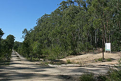
beside Seaton Track in the Colquhoun State Forest. The Discovery Trail heads south on a narrow path through the eucalyptus
forest
, while the Rail Trail travels east-west on a wide clearing following the route of the former Orbost railway line
.
The trail initially travels close to the route of Seaton Track, but their routes soon diverge and the trail continues south through isolated bush. The track surface is coarse stony gravel in this section, much of it formed from crushed granite from the quarry. Parts of the trail in this section are narrow, with some very steep grades, and should be approached with care.
After 4 km the trail descends steeply to Quarry Road and travels beside this for a short distance, before offering a detour to the granite
quarry
near Mississippi Creek. This quarry is now abandoned, but operated during the first half of the twentieth century originally to provide granite used to build a permanent entrance to the Gippsland Lakes
. This was to be a replacement for the timber
pylons that had been used in the original construction of an entrance, but which had suffered much damage due to the marine toledo worm
. There is a small viewing area and rest stop at the quarry.
from the quarry
to Lakes Entrance. This tramway closely followed the path of Mississippi Creek, and the Discovery Trail therefore takes the same route.
The trail continues for 7 km before crossing Log Crossing Rd, where the Log Crossing Picnic Area provides a rest stop, including toilets and parking. The Forestech campus of the East Gippsland Institute of TAFE
on the Princes Highway
is approximately 2 km away from this point, and can be reached either via a narrow walking/cycling track, or via Log Crossing Rd.
The track travels alongside Scrivener Rd for 3 km, gradually turning north-east. Where Scrivener Rd meets the Lakes-Colquhoun Rd the track again turns south-south-east and travels along Lakes-Colquhoun Rd for about 5 km of generally flat to undulating road, before a final 3 km descent into Lakes Entrance
. A very rough track is available beside the road for part of this route, but cyclists in particular are best advised to take the road itself. The Lakes-Colquhoun Rd joins the Princes Highway
at the eastern end of the main Lakes Entrance shopping strip.
Rail trail
A rail trail is the conversion of a disused railway easement into a multi-use path, typically for walking, cycling and sometimes horse riding. The characteristics of former tracks—flat, long, frequently running through historical areas—are appealing for various development. The term sometimes also...
in East Gippsland
East Gippsland
East Gippsland is the eastern region of Gippsland, Australia covering 31,740 square kilometres of Victoria. It has a population of 80,114....
, Victoria
Victoria (Australia)
Victoria is the second most populous state in Australia. Geographically the smallest mainland state, Victoria is bordered by New South Wales, South Australia, and Tasmania on Boundary Islet to the north, west and south respectively....
, Australia
Australia
Australia , officially the Commonwealth of Australia, is a country in the Southern Hemisphere comprising the mainland of the Australian continent, the island of Tasmania, and numerous smaller islands in the Indian and Pacific Oceans. It is the world's sixth-largest country by total area...
, sometimes known as the Mississippi Creek Trail.
It connects the East Gippsland Rail Trail
East Gippsland Rail Trail
The East Gippsland Rail Trail is a rail trail located in East Gippsland in Victoria, Australia. The trail is a popular cycling route, beginning in Bairnsdale and extending to Orbost, following the route of the former Orbost railway line...
to Lakes Entrance
Lakes Entrance, Victoria
Lakes Entrance is a tourist resort and fishing port in eastern Victoria, Australia. It is situated approximately east of Melbourne, near a managed, man-made channel connecting the Gippsland Lakes to the Bass Strait. At the 2006 census, Lakes Entrance had a population of 4,094.The township was...
, much of it running through the Colquhoun State Forest. It follows the route of a former tramway used to transport granite
Granite
Granite is a common and widely occurring type of intrusive, felsic, igneous rock. Granite usually has a medium- to coarse-grained texture. Occasionally some individual crystals are larger than the groundmass, in which case the texture is known as porphyritic. A granitic rock with a porphyritic...
from a quarry
Quarry
A quarry is a type of open-pit mine from which rock or minerals are extracted. Quarries are generally used for extracting building materials, such as dimension stone, construction aggregate, riprap, sand, and gravel. They are often collocated with concrete and asphalt plants due to the requirement...
to Lakes Entrance.
Work to build the trail was initiated in 2000 as part of a state wide Government program to expand the rail trail network, and it was fully completed in 2003. Its surface is gravel and crushed granite. Some sections of the trail are suitable only for mountain bike
Mountain bike
A mountain bike or mountain bicycle is a bicycle created for off-road cycling. This activity includes traversing of rocks and washouts, and steep declines,...
s or sturdy hybrid bikes
Hybrid bicycle
A hybrid bicycle is a bicycle designed for general-purpose utility and commuting on a wide variety of surfaces, including paved and unpaved roads, paths and trails...
.
East Gippsland Rail Trail to Granite Quarry (5 km)
The trail commences at a junction with the East Gippsland Rail TrailEast Gippsland Rail Trail
The East Gippsland Rail Trail is a rail trail located in East Gippsland in Victoria, Australia. The trail is a popular cycling route, beginning in Bairnsdale and extending to Orbost, following the route of the former Orbost railway line...
beside Seaton Track in the Colquhoun State Forest. The Discovery Trail heads south on a narrow path through the eucalyptus
Eucalyptus
Eucalyptus is a diverse genus of flowering trees in the myrtle family, Myrtaceae. Members of the genus dominate the tree flora of Australia...
forest
Forest
A forest, also referred to as a wood or the woods, is an area with a high density of trees. As with cities, depending where you are in the world, what is considered a forest may vary significantly in size and have various classification according to how and what of the forest is composed...
, while the Rail Trail travels east-west on a wide clearing following the route of the former Orbost railway line
Orbost railway line
The Orbost railway line is a railway serving the Latrobe Valley and Gippsland regions of Victoria, Australia...
.
The trail initially travels close to the route of Seaton Track, but their routes soon diverge and the trail continues south through isolated bush. The track surface is coarse stony gravel in this section, much of it formed from crushed granite from the quarry. Parts of the trail in this section are narrow, with some very steep grades, and should be approached with care.
After 4 km the trail descends steeply to Quarry Road and travels beside this for a short distance, before offering a detour to the granite
Granite
Granite is a common and widely occurring type of intrusive, felsic, igneous rock. Granite usually has a medium- to coarse-grained texture. Occasionally some individual crystals are larger than the groundmass, in which case the texture is known as porphyritic. A granitic rock with a porphyritic...
quarry
Quarry
A quarry is a type of open-pit mine from which rock or minerals are extracted. Quarries are generally used for extracting building materials, such as dimension stone, construction aggregate, riprap, sand, and gravel. They are often collocated with concrete and asphalt plants due to the requirement...
near Mississippi Creek. This quarry is now abandoned, but operated during the first half of the twentieth century originally to provide granite used to build a permanent entrance to the Gippsland Lakes
Gippsland Lakes
The Gippsland Lakes are a network of lakes, marshes and lagoons in east Gippsland, Victoria, Australia covering an area of about 600 km2. The largest of the lakes are Lake Wellington , Lake King and Lake Victoria. They are fed by the Avon, Thomson, Latrobe, Mitchell, Nicholson and Tambo...
. This was to be a replacement for the timber
Timber
Timber may refer to:* Timber, a term common in the United Kingdom and Australia for wood materials * Timber, Oregon, an unincorporated community in the U.S...
pylons that had been used in the original construction of an entrance, but which had suffered much damage due to the marine toledo worm
Marine worm
Any worm that lives in a marine environment is considered a marine worm. Marine worms are found in several different phyla, including the Platyhelminthes, Nematoda, Annelida , Chaetognatha, Hemichordata, and Phoronida....
. There is a small viewing area and rest stop at the quarry.
 |
Granite Quarry to Log Crossing Picnic Area (Forestech) (7 km)
The main trail must be rejoined following the same short detour used to access the quarry. The trail in this section follows the route of the original Mississippi Creek Tramway which was constructed in the early 1900s and used until the 1930s to transport graniteGranite
Granite is a common and widely occurring type of intrusive, felsic, igneous rock. Granite usually has a medium- to coarse-grained texture. Occasionally some individual crystals are larger than the groundmass, in which case the texture is known as porphyritic. A granitic rock with a porphyritic...
from the quarry
Quarry
A quarry is a type of open-pit mine from which rock or minerals are extracted. Quarries are generally used for extracting building materials, such as dimension stone, construction aggregate, riprap, sand, and gravel. They are often collocated with concrete and asphalt plants due to the requirement...
to Lakes Entrance. This tramway closely followed the path of Mississippi Creek, and the Discovery Trail therefore takes the same route.
The trail continues for 7 km before crossing Log Crossing Rd, where the Log Crossing Picnic Area provides a rest stop, including toilets and parking. The Forestech campus of the East Gippsland Institute of TAFE
East Gippsland Institute of TAFE
Advance TAFE is a TAFE institute located in the East Gippsland region of Victoria, Australia. It has campuses located at Bairnsdale, Lakes Entrance, Sale, and outreach centres located in the small towns of Buchan, Heyfield, Mallacoota, Orbost, Swifts Creek and Yarram.A wide selection of study...
on the Princes Highway
Princes Highway
The Princes Highway extends from Sydney to Port Augusta via the coast through the states of New South Wales, Victoria and South Australia, a distance of 1941 km or 1898 km via the former alignments of the highway ....
is approximately 2 km away from this point, and can be reached either via a narrow walking/cycling track, or via Log Crossing Rd.
Log Crossing Picnic Area to Lakes Entrance (13 km)
The trail continues south-south-east from the Log Crossing Picnic Area for 2 km until it meets Scrivener Rd; a parking bay is available at this location. The trail diverges from Mississippi Creek at this point, and trail users must travel about 100m east along Scrivener Rd before the trail recommences on the opposite side of the road at the foot of a steep hill.The track travels alongside Scrivener Rd for 3 km, gradually turning north-east. Where Scrivener Rd meets the Lakes-Colquhoun Rd the track again turns south-south-east and travels along Lakes-Colquhoun Rd for about 5 km of generally flat to undulating road, before a final 3 km descent into Lakes Entrance
Lakes Entrance, Victoria
Lakes Entrance is a tourist resort and fishing port in eastern Victoria, Australia. It is situated approximately east of Melbourne, near a managed, man-made channel connecting the Gippsland Lakes to the Bass Strait. At the 2006 census, Lakes Entrance had a population of 4,094.The township was...
. A very rough track is available beside the road for part of this route, but cyclists in particular are best advised to take the road itself. The Lakes-Colquhoun Rd joins the Princes Highway
Princes Highway
The Princes Highway extends from Sydney to Port Augusta via the coast through the states of New South Wales, Victoria and South Australia, a distance of 1941 km or 1898 km via the former alignments of the highway ....
at the eastern end of the main Lakes Entrance shopping strip.