

Lidcombe, New South Wales
Encyclopedia
Lidcombe is a suburb
in western
Sydney
, in the state of New South Wales
Australia
. Lidcombe is located 14 kilometres west of the Sydney central business district
, in the local government area of Auburn Council
.
Lidcombe is located north of Rookwood Cemetery
, the largest cemetery in the Southern Hemisphere
.
from 1804. A railway station called Haslam's Creek was opened in this area in 1859, on the railway line from Sydney to Parramatta
. Haslam's Creek is sometimes referred to as Haslem's Creek.
Although it had not been intended to construct a station at Haslam's Creek, the then owner of the land where the station now stands, Father John Joseph Therry, together with nearby landholders Potts and Blaxland, agreed to pay £700 to enable its construction.
Haslam's Creek was the site of the first railway disaster in New South Wales in July 1858 which resulted in two deaths.
When the necropolis
opened in 1867 it was known as Haslam's Creek Cemetery. Residents disliked the association with the burial ground and in 1876 the suburb was renamed Rookwood
from a title of a novel by William Harrison Ainsworth
(1805–1882). The name of the railway station was changed to Rookwood in 1878 and by the 1880s shops were established in the area. In 1891, the municipality of Rookwood was incorporated. Over time, the necropolis had become known as Rookwood Cemetery
and by 1898 residents were again agitated about the association of their suburb with the cemetery. In 1913, a new name was suggested to honour the previous mayor Mr Lidbury and the current mayor Mr Larcombe. Syllables from the name of each alderman (Lidbury and Larcombe) were combined to form the name Lidcombe on 1 January 1914. The municipality amalgamated with Auburn
local government area in 1949.
A large number of post-WWII European migrants, including a large number of Ukrainians, settled in the area of Lidcombe, and built a number of buildings including a church, 2 halls and 2 schools. Lidcombe is still the cultural centre of the Ukrainian
community in Sydney. The population dynamics changed with the influx of Middle Eastern immigrants in the 1960s and 1970s.
The two main streets are John and Joseph, named after the early colonial priest John Joseph Terry.
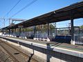 Lidcombe railway station is a junction for seven railway lines:
A railway service from the Mortuary railway station, near Central railway station
, once ran to a platform at the nearby cemetery, but has since closed.
Veolia Transport
runs two routes via Lidcombe railway station:
NightRide
runs two routes via Lidcombe station:
 Lidcombe has many places of worship including:
St Joachim's Parish School is a Catholic school on Mary Street. The Sisters of St Joseph founded the school in 1885 and remained active in the school until 1984. After that time the Sisters handed the Principalship over to lay staff who have continued to uphold the traditions and spirit of Blessed Mary MacKillop, who walked the playground and worked at the school, and her Josephite Sisters. The school caters for children up to Year 6.
Marist Brothers was a boys school located on Keating Street, behind St. Joachim's Catholic Church. It closed following the amalgamation of several Catholic schools in the area. The school catered for boys up to Year 6. This site is used for various Catholic Church
enterprises, including the Inner Western Regional Office of the Catholic Education Office, Sydney, the Catholic Adult Education Centre and a bookstore specialising in Catholic publications ("The Mustard Seed").
, situated in Church Street, on the northern side of the railway line, was the home ground of the Western Suburbs Magpies from 1967–1986. The playing surface is enclosed by a cycling track. The ground earned a reputation as a fortress for the home side, particularly in the late 1970s to the early 1980s when the Magpies were at their most competitive. Games against rivals Parramatta and Manly would usually draw large crowds during this era. The attendance record for the venue is 21,015 (Wests vs Parramatta, 30.7.78).
, Lidcombe between Wetherill Street and Hill Road in an area currently covered by the M4 Western Motorway
. The “Old Course” was in an area of three paddocks north of Fariola Street in an area owned by the Newington State Hospital (now Silverwater Correctional Centre
) which consisted of nine holes in the top paddock (holes one-eight and eighteen). Seven holes in the bottom paddock, now Wilson Park, and the sixteenth and seventeenth holes in a paddock leased from Lidcombe Council on the southern side of Holker Street. This course was in use from 1932 until early 1943 when the top paddock and the Clubhouse were taken over by the U.S. Navy during World War II
. The Silverwater Course was used from 1942 to 1949 and was a nine-hole course where the bottom paddock held holes one-two and five-nine with the third and fourth holes in the Council paddock. The present site which originally consisted of Lidcombe Sports and Showground and the western grazing paddock of Lidcombe State Hospital was obtained in 1947 and officially opened in December, 1949.
Suburb
The word suburb mostly refers to a residential area, either existing as part of a city or as a separate residential community within commuting distance of a city . Some suburbs have a degree of administrative autonomy, and most have lower population density than inner city neighborhoods...
in western
Greater Western Sydney
Greater Western Sydney is a term used to describe the western region of the metropolitan area of Sydney, Australia. The University of Western Sydney defines Greater Western Sydney as comprising 14 local government areas...
Sydney
Sydney
Sydney is the most populous city in Australia and the state capital of New South Wales. Sydney is located on Australia's south-east coast of the Tasman Sea. As of June 2010, the greater metropolitan area had an approximate population of 4.6 million people...
, in the state of New South Wales
New South Wales
New South Wales is a state of :Australia, located in the east of the country. It is bordered by Queensland, Victoria and South Australia to the north, south and west respectively. To the east, the state is bordered by the Tasman Sea, which forms part of the Pacific Ocean. New South Wales...
Australia
Australia
Australia , officially the Commonwealth of Australia, is a country in the Southern Hemisphere comprising the mainland of the Australian continent, the island of Tasmania, and numerous smaller islands in the Indian and Pacific Oceans. It is the world's sixth-largest country by total area...
. Lidcombe is located 14 kilometres west of the Sydney central business district
Sydney central business district
The Sydney central business district is the main commercial centre of Sydney, New South Wales, Australia. It extends southwards for about 3 kilometres from Sydney Cove, the point of first European settlement. Its north–south axis runs from Circular Quay in the north to Central railway station in...
, in the local government area of Auburn Council
Auburn Council
Auburn Council is the governing body of a local government area in Sydney, New South Wales, Australia, about 15 kilometres west of the Sydney central business district...
.
Lidcombe is located north of Rookwood Cemetery
Rookwood Cemetery
Rookwood Cemetery is the largest multicultural necropolis in the Southern Hemisphere, located in Sydney, New South Wales, Australia...
, the largest cemetery in the Southern Hemisphere
Southern Hemisphere
The Southern Hemisphere is the part of Earth that lies south of the equator. The word hemisphere literally means 'half ball' or "half sphere"...
.
History
Samuel Haslam owned various grants beside Haslams CreekHaslams Creek
Haslams Creek is located in Sydney, Australia. It flows through Sydney Olympic Park.-External links:***...
from 1804. A railway station called Haslam's Creek was opened in this area in 1859, on the railway line from Sydney to Parramatta
Parramatta, New South Wales
Parramatta is a suburb of Sydney, in the state of New South Wales, Australia. It is located in Greater Western Sydney west of the Sydney central business district on the banks of the Parramatta River. Parramatta is the administrative seat of the Local Government Area of the City of Parramatta...
. Haslam's Creek is sometimes referred to as Haslem's Creek.
Although it had not been intended to construct a station at Haslam's Creek, the then owner of the land where the station now stands, Father John Joseph Therry, together with nearby landholders Potts and Blaxland, agreed to pay £700 to enable its construction.
Haslam's Creek was the site of the first railway disaster in New South Wales in July 1858 which resulted in two deaths.
When the necropolis
Necropolis
A necropolis is a large cemetery or burial ground, usually including structural tombs. The word comes from the Greek νεκρόπολις - nekropolis, literally meaning "city of the dead"...
opened in 1867 it was known as Haslam's Creek Cemetery. Residents disliked the association with the burial ground and in 1876 the suburb was renamed Rookwood
Rookwood, New South Wales
Rookwood is a suburb in western Sydney, in the state of New South Wales Australia. Rookwood is located 17 kilometres south-west of the Sydney central business district, in the local government area of Auburn Council....
from a title of a novel by William Harrison Ainsworth
William Harrison Ainsworth
William Harrison Ainsworth was an English historical novelist born in Manchester. He trained as a lawyer, but the legal profession held no attraction for him. While completing his legal studies in London he met the publisher John Ebers, at that time manager of the King's Theatre, Haymarket...
(1805–1882). The name of the railway station was changed to Rookwood in 1878 and by the 1880s shops were established in the area. In 1891, the municipality of Rookwood was incorporated. Over time, the necropolis had become known as Rookwood Cemetery
Rookwood Cemetery
Rookwood Cemetery is the largest multicultural necropolis in the Southern Hemisphere, located in Sydney, New South Wales, Australia...
and by 1898 residents were again agitated about the association of their suburb with the cemetery. In 1913, a new name was suggested to honour the previous mayor Mr Lidbury and the current mayor Mr Larcombe. Syllables from the name of each alderman (Lidbury and Larcombe) were combined to form the name Lidcombe on 1 January 1914. The municipality amalgamated with Auburn
Auburn, New South Wales
Auburn is a suburb in western Sydney, in the state of New South Wales Australia. Auburn is located 19 kilometres west of the Sydney central business district and is the administrative centre of the local government area of Auburn Council.-History:...
local government area in 1949.
A large number of post-WWII European migrants, including a large number of Ukrainians, settled in the area of Lidcombe, and built a number of buildings including a church, 2 halls and 2 schools. Lidcombe is still the cultural centre of the Ukrainian
Ukrainian Australian
The Ukrainians are an ethnic minority in Australia, numbering about 20,000 people, hence making up 0.16% of the total population. Currently, the main concentrations of Ukrainians are located in Melbourne and Sydney.- History :...
community in Sydney. The population dynamics changed with the influx of Middle Eastern immigrants in the 1960s and 1970s.
The two main streets are John and Joseph, named after the early colonial priest John Joseph Terry.
Trains
- the Olympic Park line for Special Events services
- the Blue Mountains line to LithgowLithgow, New South WalesLithgow is a city in the Central Tablelands of New South Wales, Australia and is the centre of the local political division City of Lithgow. It is located in a mountain valley named Lithgow's Valley by John Oxley in honour of William Lithgow, the first Auditor-General of New South Wales.Lithgow is...
via KatoombaKatoomba, New South WalesKatoomba is the chief town of the City of Blue Mountains in New South Wales, Australia and the administrative headquarters of Blue Mountains City Council. It is on the Great Western Highway 110 kilometres west of Sydney and 39 kilometres south-east of Lithgow. Katoomba railway station is on the... - the North Shore line to BerowraBerowra, New South WalesBerowra is a suburb of northern Sydney, in the state of New South Wales, Australia. Berowra is located 38 kilometres north of the Sydney central business district, in the local government area of Hornsby Shire...
via the City and ChatswoodChatswood, New South WalesChatswood is a suburb on the North Shore of Sydney, in the state of New South Wales, Australia. Chatswood is located 10 kilometres north of the Sydney central business district and is the administrative centre of the local government area of the City of Willoughby. Chatswood West is a separate suburb... - the Western lineWestern railway line, SydneyThe Western Line is part of the CityRail metropolitan rail network in Sydney, and is the suburban section of the Main West line which connects Sydney with the west of New South Wales. It connects the Sydney CBD to the employment centre of Parramatta and the outer western suburbs, terminating at Emu...
to either RichmondRichmond, New South WalesRichmond is a town in New South Wales, north-west of Sydney, in the Local Government Area of the City of Hawkesbury. It is located at a latitude of 33° 35' 54" South and a longitude of 150°45' 04" east, 19 metres above sea level on the alluvial Hawkesbury River flats, at the foot of the Blue...
or Emu PlainsEmu Plains, New South WalesEmu Plains is a town, in the state of New South Wales, Australia. Emu Plains is located 58 kilometres west of the Sydney central business district, in the local government area of the City of Penrith and is part of the Greater Western Sydney region....
via ParramattaParramatta, New South WalesParramatta is a suburb of Sydney, in the state of New South Wales, Australia. It is located in Greater Western Sydney west of the Sydney central business district on the banks of the Parramatta River. Parramatta is the administrative seat of the Local Government Area of the City of Parramatta... - the South lineSouth railway line, SydneyThe South Line is a railway line in Sydney, New South Wales, Australia, and is part of the CityRail suburban network...
to CampbelltownCampbelltown, New South WalesCampbelltown is a suburb in south-western Sydney, in the state of New South Wales, Australia. Campbelltown is located 51 kilometres south-west of the Sydney central business district and is the administrative centre for the local government area of the City of Campbelltown.- History :Campbelltown...
via GranvilleGranville, New South WalesGranville, is a suburb in western Sydney, Australia. Granville is located west of the Sydney central business district, in the local government area of the City of Parramatta. A small part in the north-west is located in the Local Government Area of the City of Holroyd.South Granville is a... - the Inner West line to LiverpoolLiverpool, New South WalesLiverpool is a suburb in south-western Sydney, in the state of New South Wales, Australia. Liverpool is located 32 km south-west of the Sydney central business district, and is the administrative centre of the local government area of the City of Liverpool...
via Regents ParkRegents Park, New South WalesAlternate uses: Regents Park Regents Park is a western suburb of Sydney, in the state of New South Wales, Australia. Regents Park is located 22 kilometres west of the Sydney central business district, in the local government area of Auburn Council.-History:The suburb took its name from a local... - the Bankstown line to the City via BankstownBankstown, New South WalesBankstown is a suburb of south-western Sydney, in the state of New South Wales, Australia. Bankstown is located 20 kilometres south-west of the Sydney central business district and is the administrative centre of the local government area of the City of Bankstown.-History:Prior to European...
A railway service from the Mortuary railway station, near Central railway station
Central railway station, Sydney
Central Railway Station, the largest railway station in Australia, is at the southern end of the Sydney CBD. It services almost all the lines on the CityRail network, and is the major terminus for interurban and interstate rail services...
, once ran to a platform at the nearby cemetery, but has since closed.
Bus services
Sydney Buses runs one route via Lidcombe station:- Route 401 - to Sydney Olympic Park station via Parramatta RoadParramatta Road.Parramatta Road is the major historical east-west artery of metropolitan Sydney, Australia, connecting the Sydney with Parramatta. It is the eastern-most part of the Great Western Highway. Much of its traffic has been diverted to modern expressways such as the M4 and the City West Link...
, Homebush Bay, Athletic Centre, Olympic Park railway station
Veolia Transport
Veolia Transport NSW
Veolia Transport NSW is a division of the global Veolia company that operates the Metro Light Rail, the Metro Monorail and commuter bus services in the southern suburbs of Sydney, New South Wales, Australia.-Metro Transport:...
runs two routes via Lidcombe railway station:
- Route 912 - to Bankstown
- Route 915 - to University of Sydney Cumberland Campus
NightRide
NightRide
NightRide is a network of bus routes in operation between midnight and 5.00 am in Sydney, Australia. The eleven routes are run by private bus operators and allow for a nightly shutdown of the CityRail commuter rail network. Established by the New South Wales Ministry of Transport and monitored by...
runs two routes via Lidcombe station:
- Route N50 - Between LiverpoolLiverpool, New South WalesLiverpool is a suburb in south-western Sydney, in the state of New South Wales, Australia. Liverpool is located 32 km south-west of the Sydney central business district, and is the administrative centre of the local government area of the City of Liverpool...
and City (Town Hall) - Route N60 - Between Fairfield stationFairfield railway station, Sydney-Bus services:Fairfield Bus InterchangeWestbus:*824 - to Wakeley.*825 - weekdays and Saturday services - to Greenfield Park*826 - weekdays and Saturday services - to Cabramatta...
and City (Town Hall)
Landmarks
- The Juniperina Juvenile Justice Centre at Rookwood Road, is a juvenile detention centre for girls. It is the only detention facility catering for juvenile female offenders in New South WalesNew South WalesNew South Wales is a state of :Australia, located in the east of the country. It is bordered by Queensland, Victoria and South Australia to the north, south and west respectively. To the east, the state is bordered by the Tasman Sea, which forms part of the Pacific Ocean. New South Wales...
. The Centre was also used as a filming location for the UK-Australian TV mini series, 'The Leaving of LiverpoolThe Leaving of LiverpoolThe Leaving of Liverpool is a 1992 television mini-series, an Australian–British co-production between the Australian Broadcasting Corporation and British Broadcasting Corporation...
'. - The heritage-listed Lidcombe Hospital was closed in the 1990s. It is now being developed as a residential estate. The complex was designed by Walter Liberty VernonWalter Liberty VernonWalter Liberty Vernon was an English architect who migrated to the state of New South Wales, Australia and pursued his career as an architect in Sydney...
, the Government Architect of the day, and built in 1906. It is now listed on the Register of the National Estate. - The Gables is a historic home in East Street, opposite Rookwood CemeteryRookwood CemeteryRookwood Cemetery is the largest multicultural necropolis in the Southern Hemisphere, located in Sydney, New South Wales, Australia...
, that is now used as a function centre. - Church Street is the site for the Ukrainian Youth Centre, the Ukrainian Plast (Scouts) centre, the St Andrews Ukrainian Catholic Church and its presbytery, hall, school and kindergarten, and the former Karpaty Ukrainian Credit Union. Joseph Street is the site for the Ukrainian Folk Hall, and Ukrainian Central School. Nearby is the office of "The Free Thought" newspaper.
Churches
- St Joachim's Catholic Church on John Street and Mills Street
- Sts Cyril and Methodius, a Slovak Catholic Church in Vaughan Street.
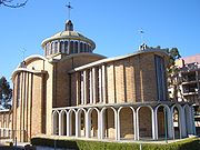
- St Andrew's Ukrainian Catholic Church (ByzantineByzantineByzantine usually refers to the Roman Empire during the Middle Ages.Byzantine may also refer to:* A citizen of the Byzantine Empire, or native Greek during the Middle Ages...
style) on Church Street - St Stephens Anglican Church on Mark Street
- Holy Annunciation - Assumption Russian Orthodox Church on Vaughan Street
- St Ephraim Syrian Orthodox Church on Joseph Street
- Lidcombe Baptist Church on Kerrs Road
- Our Lady of the Assumption Armenian Catholic Church on John Street
- Pacific Island Christian Church on Martin Street
- Christian Church on the corner of Olympic Drive and Vaughan Street
- St Marks Presbyterian Church in Yarram Street is now closed and for sale
Schools
Lidcombe Public School, located on John Street, was established in 1879. The school has 600 students and caters for special education children with trained teachers in that field. The school provides extra-curricular education facilities such as a choir, dance group, PSSA sports team.St Joachim's Parish School is a Catholic school on Mary Street. The Sisters of St Joseph founded the school in 1885 and remained active in the school until 1984. After that time the Sisters handed the Principalship over to lay staff who have continued to uphold the traditions and spirit of Blessed Mary MacKillop, who walked the playground and worked at the school, and her Josephite Sisters. The school caters for children up to Year 6.
Marist Brothers was a boys school located on Keating Street, behind St. Joachim's Catholic Church. It closed following the amalgamation of several Catholic schools in the area. The school catered for boys up to Year 6. This site is used for various Catholic Church
Roman Catholic Church
The Catholic Church, also known as the Roman Catholic Church, is the world's largest Christian church, with over a billion members. Led by the Pope, it defines its mission as spreading the gospel of Jesus Christ, administering the sacraments and exercising charity...
enterprises, including the Inner Western Regional Office of the Catholic Education Office, Sydney, the Catholic Adult Education Centre and a bookstore specialising in Catholic publications ("The Mustard Seed").
Commercial area
Lidcombe has a mixture of residential, commercial and industrial developments. A small shopping centre is located close to Lidcombe railway station. Commercial and industrial developments are located along Parramatta Road and surrounding areas.Industry
- Macquarie Goodman own a couple of business parks on Parramatta Road and Birnie Avenue.
- The Dairy FarmersDairy FarmersDairy Farmers is one of the largest and oldest dairy manufacturers in Australia, established in 1900, supplying products to local and international markets such as Eastern Europe, the Middle East and Asia. Kirin Holdings Company, Limited of Japan, via its subsidiary National Foods, acquired the...
' distribution centre is located at Birnie Avenue. Dairy Farmers is a milk co-operative and supplied most of NSW's milk before competition was opened to milk suppliers from other states. - Masons servicing the nearby Rookwood CemeteryRookwood CemeteryRookwood Cemetery is the largest multicultural necropolis in the Southern Hemisphere, located in Sydney, New South Wales, Australia...
are located on Railway Street - Arthur Street business park just on the border with Strathfield MunicipalityMunicipality of StrathfieldThe Municipality of Strathfield is a Local Government Area of Sydney, New South Wales, Australia. The Municipality incorporates the suburbs of Flemington, Homebush, Homebush West, Strathfield South entirely, and shares the following suburbs with other Councils, Belfield, Greenacre, and Strathfield...
. - Dooley's Lidcombe Catholic Club (there is a franchise in SilverwaterSilverwater, New South WalesSilverwater is a suburb in western Sydney, in the state of New South Wales Australia. Silverwater is located 20 kilometres west of the Sydney central business district, in the local government area of Auburn Council....
too) - McVicar's Bus Services depot was located at the corner of Joseph and James Streets. It closed in 1978.
- Phil Gilbert Toyota (Parramatta Road and Bombay Street)
- The TooheysTooheysTooheys is a brewery in the suburb of Lidcombe, in Sydney, New South Wales, Australia. It produces beers under the Tooheys and Hahn trademarks, and is part of the New Zealand Lion Nathan beverages group.-History:...
Brewery is located on the corner of Parramatta Road and Nyrang Street. The brewery site was bought in 1955 and the company is now part of the Lion NathanLion NathanLion Nathan National Foods is the parent company created in October 2009, into which Lion Nathan and National Foods were merged. It is fully owned by Kirin Holdings Company, Limited...
conglomerate. The smell of the hops is noticeable around the area as it wafts through the air, especially during the night. - The NSW Rural Fire Service headquarters is in Carter Street. Carter Street was part of Lidcombe before the 2000 Sydney Olympics, but later became part of Homebush BayHomebush Bay, New South WalesHomebush Bay was the former name of a suburb of western Sydney, in the state of New South Wales, Australia that took in the suburbs of Sydney Olympic Park, Wentworth Point and part of the neighbouring suburb of Lidcombe. Homebush Bay is located 16 kilometres west of the Sydney central business...
. On October 2, 2009, the suburb of Homebush Bay was dismantled into two new suburbs, Sydney Olympic ParkSydney Olympic ParkSydney Olympic Park is a suburb in western Sydney, in the state of New South Wales, Australia. Sydney Olympic Park is located 16 kilometres west of the Sydney central business district, in the local government area of Auburn Council....
and Wentworth PointWentworth Point, New South WalesWentworth Point is a suburb of western Sydney, in the state of New South Wales, Australia. Wentworth Point is located 16 kilometres west of the Sydney central business district, in the local government area of Auburn Council...
, with Carter Street reabsorbed into Lidcombe. The Olympic site was once a stockyard and abattoir.
Lidcombe Oval
Lidcombe OvalLidcombe Oval
Lidcombe Oval is a playing field in the Western Sydney suburb of Lidcombe, and is part of Wyatt Park. Situated in Church Street, on the northern side of the railway line, it has a capacity of more than 20,000 and is used mainly for football matches of various codes...
, situated in Church Street, on the northern side of the railway line, was the home ground of the Western Suburbs Magpies from 1967–1986. The playing surface is enclosed by a cycling track. The ground earned a reputation as a fortress for the home side, particularly in the late 1970s to the early 1980s when the Magpies were at their most competitive. Games against rivals Parramatta and Manly would usually draw large crowds during this era. The attendance record for the venue is 21,015 (Wests vs Parramatta, 30.7.78).
Carnarvon Golf Course
Carnarvon Golf Course, located at Nottinghill Road and Joseph Street, reflects the social history of Lidcombe. The first site was in use from 1927 to 1932 and occupied an area running east and west on the northern side of Parramatta RoadParramatta Road
.Parramatta Road is the major historical east-west artery of metropolitan Sydney, Australia, connecting the Sydney with Parramatta. It is the eastern-most part of the Great Western Highway. Much of its traffic has been diverted to modern expressways such as the M4 and the City West Link...
, Lidcombe between Wetherill Street and Hill Road in an area currently covered by the M4 Western Motorway
M4 Western Motorway
The M4 Western Motorway,, is a motorway in central Sydney, New South Wales, Australia...
. The “Old Course” was in an area of three paddocks north of Fariola Street in an area owned by the Newington State Hospital (now Silverwater Correctional Centre
Silverwater Correctional Centre
Silverwater Correctional Centre is a minimum security Australian male prison facility, located in Holker St, Silverwater, west of the Sydney central business district in New South Wales, Australia.-Notable prisoners:...
) which consisted of nine holes in the top paddock (holes one-eight and eighteen). Seven holes in the bottom paddock, now Wilson Park, and the sixteenth and seventeenth holes in a paddock leased from Lidcombe Council on the southern side of Holker Street. This course was in use from 1932 until early 1943 when the top paddock and the Clubhouse were taken over by the U.S. Navy during World War II
World War II
World War II, or the Second World War , was a global conflict lasting from 1939 to 1945, involving most of the world's nations—including all of the great powers—eventually forming two opposing military alliances: the Allies and the Axis...
. The Silverwater Course was used from 1942 to 1949 and was a nine-hole course where the bottom paddock held holes one-two and five-nine with the third and fourth holes in the Council paddock. The present site which originally consisted of Lidcombe Sports and Showground and the western grazing paddock of Lidcombe State Hospital was obtained in 1947 and officially opened in December, 1949.
Ruth Everuss Aquatic Centre
The Ruth Everuss Aquatic Centre (formerly known as the Auburn Swim Centre), located on Church Street, has indoor and outdoor swimming facilities. The Centre is named after Ruth Everuss, the Australian Olympic swimmer who won a silver medal in the women's 4x100m freestyle relay at the 1960 Rome Olympics. The Centre has a 9 lane outdoor 50m pool, a 6 lane heated indoor 25m pool and a children's wade pool. There is also a 20m diving pool, the diving tower has been condemned and is no longer used, but the pool is still accessible. The Centre has its own swim school, called First Splashes, but is also home to the Auburn Swimming Club and the Wests Auburn Masters Swimming Club.Demographics
Lidcombe was, up until recent years a traditional working-class suburb. Over the past decade, Lidcombe, particularly the northern part of the suburb, has experienced the processes of gentrification. Today, the suburb is cosmopolitan, reflecting the waves of immigration to post war Australia.Notable residents
- John Ernest Sullivan. A longstanding member of the Australian Labor Party, he went to the Marist Brothers school (now closed, since turned into the Catholic Education Office) located on Keating Street.
- Rod TaylorRod Taylor (actor)Rodney Sturt "Rod" Taylor is an Australian-American actor of film and television.-Early life:Born on 11 January 1930 in Lidcombe, a suburb of Sydney, Taylor was the only child of William Sturt Taylor, a steel construction contractor and commercial artist, and the former Mona Thompson, a writer of...
. For some years after his Hollywood success, his mother still lived at a local street (reference: Schoolfriends messageboard, now inactive). He went to Parramatta High School. - Michael Wenden. An Olympic swimmer, attended Marist Brothers Lidcombe, he won gold in the 100m and 200m freestyle, silver in the 800m freestyle relay and bronze in the 400m freestyle relay at the 1968 Mexico City Olympics.