

Dubh Artach
Encyclopedia
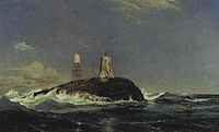
Dubh Artach is a remote skerry
of basalt
rock off the west coast of Scotland
lying 18 miles (29 km) west of Colonsay
and 15 miles (24.1 km) south-west of the Ross of Mull
.
A lighthouse
designed by Thomas Stevenson
with a tower height of 145 feet (44.2 m) was erected between 1867 and 1872 with a shore station constructed on the isle of Erraid
. The rock is subject to extraordinary sea conditions with waves of 92 feet (28 m) or more being encountered by the keepers. Despite these adverse conditions several men served the light for lengthy periods until it was automated in 1971.
Dubh Artach is the official name of the lighthouse, although the skerry itself is also known as Dhu Heartach. Various interpretations have been provided for the original meaning of the Gaelic name, of which "The Black Rock" is the most likely.
beyond the Outer Hebrides
. After the last retreat of the ice around 20,000 years ago, sea levels were up to 425 feet (129.5 m) lower than at present. Although the isostatic
rise of land makes estimating post-glacial coastlines a complex task, circa 14,000 BP
it is likely that Dubh Heartach was at the western edge of a large land bridge linking what is now the island of Ireland
to Scotland
. This land mass included the islands of Jura
and Islay
and was probably connected to the mainland of Scotland by an isthmus
near Loch Craignish, south of Oban
.
Steadily rising sea levels would then have slowly isolated and finally all but submerged Dhu Heartach, which today is a rounded, dark green mass of basalt
ic rock called augite
, which is 240 feet (73.2 m) long and 130 feet (39.6 m) wide, and which rises to 35 feet (10.7 m) above sea level. Submarine surveys indicate that the rock is at the eastern end of a valley stretching 80 miles (128.7 km) into the Atlantic, which may “account for the seemingly abnormal seas to which the tower is subjected". It is an isolated outpost of the Inner Hebrides
archipelago
. The author Robert Louis Stevenson
wrote:
and in Irish
. The variation between the anglicised forms Dubh Artach and Dhu Heartach is a simple case of false splitting where the final [h] of [t̪uh arˠʃt̪əx] in pronunciation seemingly is part of the following word, suggesting *hartach or heartach to the untrained ear.
Stevenson believed that 'black and dismal' was a translation of the name, noting that "as usual, in Gaelic, it is not the only one." Adamnan in his 7th-century Life of St Columba poetically calls the rock An Dubh Iar-stac, "The Black Stack of the West". Watson (1926) suggests the root is Old Irish hirt meaning "death", (which he also believes occurs in Hirta
, the main island of the St Kilda
archipelago), and offers am Duibh-hirteach, meaning "the black deadly one". The skerry was also known as St. John's Rock prior to the construction of the lighthouse.
 Between 1800 and 1854 thirty ships were wrecked on the reef; however, the requirement for a lighthouse was not only to warn seafarers away from Dhu Heartach itself, but also to guide them past the fearsome Torran Rocks, which lie between the Ross of Mull and Colonsay
. Originally it was considered to be an impossible site for a light, but the loss of the steamer Bussorah with all thirty-three hands on her maiden voyage in 1863 and of an astonishing 24 vessels in the area in a storm on 30-31 December 1865 encouraged positive action under pressure from insurers Lloyds of London and a Captain Bedford of the Admiralty. The engineering work was supervised by the famous Stevenson family of engineers, the brothers Thomas
(father of Robert Louis
) and David
commencing work in 1866. Thomas noted that "it would be a work of no ordinary magnitude".
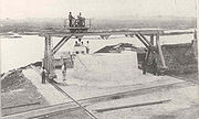 The land base for the construction of the light was Erraid
near Iona
. Fourteen miles distant from Dhu Heartach across open sea, the little island provided a granite quarry and a shore station once the work on the lighthouse was completed. Initial construction on the rock, which began on 25 June 1867 under the supervision of Alan Brebner, required a barrack for the workmen made of iron. Summer gales brought high seas, which resulted in breaking water falling on the roof 77 feet (23.5 m) above sea level. It held firm, although fourteen men including Brebner were trapped there for five days, and at one point seawater poured in through the trapdoor, swirled around them and exited with their remaining food supplies. Describing a similar occasion, R. L. Stevenson wrote:
Despite these hardships a 36 feet (11 m) diameter foundation pit was excavated and by 1869 a solid portion of tower rising 32 feet (9.8 m) above foundation level had been completed. This was no mean feat. On one occasion eleven two-ton stones were dislodged from the third course of stonework and carried off the rock, never to be seen again. Robert Stevenson noted that this destruction occurred at the same height "above the sea as the glass panes in the lantern of Smeaton's lighthouse" at Eddystone
.
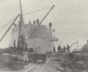 The solid base weighing 1,840 tons rises more than 64 feet (19.5 m) above the pounding seas, more than twice as high as its nearest British rival of Skerryvore
. The blocks, having been shaped and fitted on Erraid, were towed out to the rock in barges by the steamer ‘Dhuheartach’ each barge carrying 16 tons. Masonry work was completed in 1871 and the lantern, optical apparatus and fog bell installed the following year, Dubh Artach becoming the first isolated rock light in Britain to use paraffin
. The finished tower rises 101 feet (30.8 m) above the foundation in seventy-seven courses of stonework all told.
The total cost of the works undertaken by the Northern Lighthouse Board
was £65,784, excluding the £10,300 cost of establishing the shore station on Erraid. However, the extraordinary nature of the work should not be reduced to mere numbers. Stevenson was moved to note that:
Tower height
145 ft (44 m)
Characteristics
Two White Flashes every 30 secs
Description
White, circular tower with red horizontal band
Date established
1872
Date of present tower
1872
Date automated
1971
Current use
Active aid to navigation
Engineers
Thomas and David Stevenson
Open to the public
Grounds only. Landings by sea are likely to be hazardous if not impossible.
Skerry
A skerry is a small rocky island, usually defined to be too small for habitation. It may simply be a rocky reef. A skerry can also be called a low sea stack....
of basalt
Basalt
Basalt is a common extrusive volcanic rock. It is usually grey to black and fine-grained due to rapid cooling of lava at the surface of a planet. It may be porphyritic containing larger crystals in a fine matrix, or vesicular, or frothy scoria. Unweathered basalt is black or grey...
rock off the west coast of Scotland
Scotland
Scotland is a country that is part of the United Kingdom. Occupying the northern third of the island of Great Britain, it shares a border with England to the south and is bounded by the North Sea to the east, the Atlantic Ocean to the north and west, and the North Channel and Irish Sea to the...
lying 18 miles (29 km) west of Colonsay
Colonsay
Colonsay is an island in the Scottish Inner Hebrides, located north of Islay and south of Mull and has an area of . It is the ancestral home of Clan Macfie and the Colonsay branch of Clan MacNeill. Aligned on a south-west to north-east axis, it measures in length and reaches at its widest...
and 15 miles (24.1 km) south-west of the Ross of Mull
Ross of Mull
The Ross of Mull is the largest peninsula of the island of Mull, about long and makes up the south-western part of the island. It is bounded to the north by Loch Scridain and by the Firth of Lorne to the south. The main villages are Bunessan and Fionnphort with smaller settlements including...
.
A lighthouse
Lighthouse
A lighthouse is a tower, building, or other type of structure designed to emit light from a system of lamps and lenses or, in older times, from a fire, and used as an aid to navigation for maritime pilots at sea or on inland waterways....
designed by Thomas Stevenson
Thomas Stevenson
Thomas Stevenson PRSE MInstCE FRSSA FSAScot was a pioneering Scottish lighthouse designer and meteorologist, who designed over thirty lighthouses in and around Scotland, as well as the Stevenson screen used in meteorology...
with a tower height of 145 feet (44.2 m) was erected between 1867 and 1872 with a shore station constructed on the isle of Erraid
Erraid
The Isle of Erraid is a tidal island approximately one mile square in area located in the Inner Hebrides of Scotland. It lies west of Mull and southeast of Iona. The island receives about of rain and 1,350 hours of sunshine annually, making it one of the driest and sunniest places on the western...
. The rock is subject to extraordinary sea conditions with waves of 92 feet (28 m) or more being encountered by the keepers. Despite these adverse conditions several men served the light for lengthy periods until it was automated in 1971.
Dubh Artach is the official name of the lighthouse, although the skerry itself is also known as Dhu Heartach. Various interpretations have been provided for the original meaning of the Gaelic name, of which "The Black Rock" is the most likely.
Geology
In pre-historic times Dhu Heartach was covered by the ice sheets which spread from Scotland out into the Atlantic OceanAtlantic Ocean
The Atlantic Ocean is the second-largest of the world's oceanic divisions. With a total area of about , it covers approximately 20% of the Earth's surface and about 26% of its water surface area...
beyond the Outer Hebrides
Outer Hebrides
The Outer Hebrides also known as the Western Isles and the Long Island, is an island chain off the west coast of Scotland. The islands are geographically contiguous with Comhairle nan Eilean Siar, one of the 32 unitary council areas of Scotland...
. After the last retreat of the ice around 20,000 years ago, sea levels were up to 425 feet (129.5 m) lower than at present. Although the isostatic
Isostasy
Isostasy is a term used in geology to refer to the state of gravitational equilibrium between the earth's lithosphere and asthenosphere such that the tectonic plates "float" at an elevation which depends on their thickness and density. This concept is invoked to explain how different topographic...
rise of land makes estimating post-glacial coastlines a complex task, circa 14,000 BP
Before Present
Before Present years is a time scale used in archaeology, geology, and other scientific disciplines to specify when events in the past occurred. Because the "present" time changes, standard practice is to use AD 1950 as the origin of the age scale, reflecting the fact that radiocarbon...
it is likely that Dubh Heartach was at the western edge of a large land bridge linking what is now the island of Ireland
Ireland
Ireland is an island to the northwest of continental Europe. It is the third-largest island in Europe and the twentieth-largest island on Earth...
to Scotland
Scotland
Scotland is a country that is part of the United Kingdom. Occupying the northern third of the island of Great Britain, it shares a border with England to the south and is bounded by the North Sea to the east, the Atlantic Ocean to the north and west, and the North Channel and Irish Sea to the...
. This land mass included the islands of Jura
Jura, Scotland
Jura is an island in the Inner Hebrides of Scotland, situated adjacent and to the north-east of Islay. Part of the island is designated as a National Scenic Area. Until the twentieth century Jura was dominated - and most of it was eventually owned - by the Campbell clan of Inveraray Castle on Loch...
and Islay
Islay
-Prehistory:The earliest settlers on Islay were nomadic hunter-gatherers who arrived during the Mesolithic period after the retreat of the Pleistocene ice caps. In 1993 a flint arrowhead was found in a field near Bridgend dating from 10,800 BC, the earliest evidence of a human presence found so far...
and was probably connected to the mainland of Scotland by an isthmus
Isthmus
An isthmus is a narrow strip of land connecting two larger land areas usually with waterforms on either side.Canals are often built through isthmuses where they may be particularly advantageous to create a shortcut for marine transportation...
near Loch Craignish, south of Oban
Oban
Oban Oban Oban ( is a resort town within the Argyll and Bute council area of Scotland. It has a total resident population of 8,120. Despite its small size, it is the largest town between Helensburgh and Fort William and during the tourist season the town can be crowded by up to 25,000 people. Oban...
.
Steadily rising sea levels would then have slowly isolated and finally all but submerged Dhu Heartach, which today is a rounded, dark green mass of basalt
Basalt
Basalt is a common extrusive volcanic rock. It is usually grey to black and fine-grained due to rapid cooling of lava at the surface of a planet. It may be porphyritic containing larger crystals in a fine matrix, or vesicular, or frothy scoria. Unweathered basalt is black or grey...
ic rock called augite
Augite
Augite is a single chain inosilicate mineral, 2O6. The crystals are monoclinic and prismatic. Augite has two prominent cleavages, meeting at angles near 90 degrees.-Characteristics:Augite is a solid solution in the pyroxene group...
, which is 240 feet (73.2 m) long and 130 feet (39.6 m) wide, and which rises to 35 feet (10.7 m) above sea level. Submarine surveys indicate that the rock is at the eastern end of a valley stretching 80 miles (128.7 km) into the Atlantic, which may “account for the seemingly abnormal seas to which the tower is subjected". It is an isolated outpost of the Inner Hebrides
Inner Hebrides
The Inner Hebrides is an archipelago off the west coast of Scotland, to the south east of the Outer Hebrides. Together these two island chains form the Hebrides, which enjoy a mild oceanic climate. There are 36 inhabited islands and a further 43 uninhabited Inner Hebrides with an area greater than...
archipelago
Archipelago
An archipelago , sometimes called an island group, is a chain or cluster of islands. The word archipelago is derived from the Greek ἄρχι- – arkhi- and πέλαγος – pélagos through the Italian arcipelago...
. The author Robert Louis Stevenson
Robert Louis Stevenson
Robert Louis Balfour Stevenson was a Scottish novelist, poet, essayist and travel writer. His best-known books include Treasure Island, Kidnapped, and Strange Case of Dr Jekyll and Mr Hyde....
wrote:
An ugly reef is this of the Dhu Heartach; no pleasant assemblage of shelves, and pools, and creeks, about which a child might play for a whole summer without weariness, like the Bell RockInchcapeInchcape or the Bell Rock is a notorious reef off the east coast of Angus, Scotland, near Dundee and Fife . Bell Rock Lighthouse, an automatic lighthouse, occupies the reef...
or the SkerryvoreSkerryvoreSkerryvore is a remote reef that lies off the west coast of Scotland, 12 miles south west of the island of Tiree...
, but one oval nodule of black-trap, sparsely bedabbled with an inconspicuous fucus, and alive in every crevice with a dingy insect between a slater and a bug. No other life was there but of sea-birds, and of the sea itself, that here ran like a mill-race, and growled about the outer reef for ever, and ever and again, in the calmest weather, roared and spouted on the rock itself.
Meaning of the name
The translation of Dubh Artach is "The Black Rock", artach being a now obsolete Gaelic word for a rock or rocky ground both in Scottish GaelicScottish Gaelic language
Scottish Gaelic is a Celtic language native to Scotland. A member of the Goidelic branch of the Celtic languages, Scottish Gaelic, like Modern Irish and Manx, developed out of Middle Irish, and thus descends ultimately from Primitive Irish....
and in Irish
Irish language
Irish , also known as Irish Gaelic, is a Goidelic language of the Indo-European language family, originating in Ireland and historically spoken by the Irish people. Irish is now spoken as a first language by a minority of Irish people, as well as being a second language of a larger proportion of...
. The variation between the anglicised forms Dubh Artach and Dhu Heartach is a simple case of false splitting where the final [h] of [t̪uh arˠʃt̪əx] in pronunciation seemingly is part of the following word, suggesting *hartach or heartach to the untrained ear.
Stevenson believed that 'black and dismal' was a translation of the name, noting that "as usual, in Gaelic, it is not the only one." Adamnan in his 7th-century Life of St Columba poetically calls the rock An Dubh Iar-stac, "The Black Stack of the West". Watson (1926) suggests the root is Old Irish hirt meaning "death", (which he also believes occurs in Hirta
Hirta
Hirta is the largest island in the St Kilda archipelago, on the western edge of Scotland. The name "Hiort" and "Hirta" have also been applied to the entire archipelago.-Geography:...
, the main island of the St Kilda
St Kilda, Scotland
St Kilda is an isolated archipelago west-northwest of North Uist in the North Atlantic Ocean. It contains the westernmost islands of the Outer Hebrides of Scotland. The largest island is Hirta, whose sea cliffs are the highest in the United Kingdom and three other islands , were also used for...
archipelago), and offers am Duibh-hirteach, meaning "the black deadly one". The skerry was also known as St. John's Rock prior to the construction of the lighthouse.
Planning and construction of the lighthouse
Colonsay
Colonsay is an island in the Scottish Inner Hebrides, located north of Islay and south of Mull and has an area of . It is the ancestral home of Clan Macfie and the Colonsay branch of Clan MacNeill. Aligned on a south-west to north-east axis, it measures in length and reaches at its widest...
. Originally it was considered to be an impossible site for a light, but the loss of the steamer Bussorah with all thirty-three hands on her maiden voyage in 1863 and of an astonishing 24 vessels in the area in a storm on 30-31 December 1865 encouraged positive action under pressure from insurers Lloyds of London and a Captain Bedford of the Admiralty. The engineering work was supervised by the famous Stevenson family of engineers, the brothers Thomas
Thomas Stevenson
Thomas Stevenson PRSE MInstCE FRSSA FSAScot was a pioneering Scottish lighthouse designer and meteorologist, who designed over thirty lighthouses in and around Scotland, as well as the Stevenson screen used in meteorology...
(father of Robert Louis
Robert Louis Stevenson
Robert Louis Balfour Stevenson was a Scottish novelist, poet, essayist and travel writer. His best-known books include Treasure Island, Kidnapped, and Strange Case of Dr Jekyll and Mr Hyde....
) and David
David Stevenson (engineer)
David Stevenson FRSE FRSSA was a Scottish lighthouse designer, who designed over thirty lighthouses in and around Scotland, and helped found a great dynasty of lighthouse engineering.-Background:...
commencing work in 1866. Thomas noted that "it would be a work of no ordinary magnitude".
Erraid
The Isle of Erraid is a tidal island approximately one mile square in area located in the Inner Hebrides of Scotland. It lies west of Mull and southeast of Iona. The island receives about of rain and 1,350 hours of sunshine annually, making it one of the driest and sunniest places on the western...
near Iona
Iona
Iona is a small island in the Inner Hebrides off the western coast of Scotland. It was a centre of Irish monasticism for four centuries and is today renowned for its tranquility and natural beauty. It is a popular tourist destination and a place for retreats...
. Fourteen miles distant from Dhu Heartach across open sea, the little island provided a granite quarry and a shore station once the work on the lighthouse was completed. Initial construction on the rock, which began on 25 June 1867 under the supervision of Alan Brebner, required a barrack for the workmen made of iron. Summer gales brought high seas, which resulted in breaking water falling on the roof 77 feet (23.5 m) above sea level. It held firm, although fourteen men including Brebner were trapped there for five days, and at one point seawater poured in through the trapdoor, swirled around them and exited with their remaining food supplies. Describing a similar occasion, R. L. Stevenson wrote:
The men sat high up prisoned in their iron drum, that then resounded with the lashings of the sprays ... It was then that the foreman builder, Mr. Goodwillie, whom I see before me in his rock-habit of indecipherable rags, would get his fiddle down and strike up human minstrelsy amid the music of the storms.
Despite these hardships a 36 feet (11 m) diameter foundation pit was excavated and by 1869 a solid portion of tower rising 32 feet (9.8 m) above foundation level had been completed. This was no mean feat. On one occasion eleven two-ton stones were dislodged from the third course of stonework and carried off the rock, never to be seen again. Robert Stevenson noted that this destruction occurred at the same height "above the sea as the glass panes in the lantern of Smeaton's lighthouse" at Eddystone
Eddystone Lighthouse
Eddystone Lighthouse is on the treacherous Eddystone Rocks, south west of Rame Head, United Kingdom. While Rame Head is in Cornwall, the rocks are in Devon and composed of Precambrian Gneiss....
.
Skerryvore
Skerryvore is a remote reef that lies off the west coast of Scotland, 12 miles south west of the island of Tiree...
. The blocks, having been shaped and fitted on Erraid, were towed out to the rock in barges by the steamer ‘Dhuheartach’ each barge carrying 16 tons. Masonry work was completed in 1871 and the lantern, optical apparatus and fog bell installed the following year, Dubh Artach becoming the first isolated rock light in Britain to use paraffin
Paraffin
In chemistry, paraffin is a term that can be used synonymously with "alkane", indicating hydrocarbons with the general formula CnH2n+2. Paraffin wax refers to a mixture of alkanes that falls within the 20 ≤ n ≤ 40 range; they are found in the solid state at room temperature and begin to enter the...
. The finished tower rises 101 feet (30.8 m) above the foundation in seventy-seven courses of stonework all told.
The total cost of the works undertaken by the Northern Lighthouse Board
Northern Lighthouse Board
The Northern Lighthouse Board is the General Lighthouse Authority for Scotland and the Isle of Man. It is a non-departmental public body responsible for marine navigation aids around coastal areas.-History:...
was £65,784, excluding the £10,300 cost of establishing the shore station on Erraid. However, the extraordinary nature of the work should not be reduced to mere numbers. Stevenson was moved to note that:
It would be ungenerous if a great and dangerous work like this were brought unsuccessfully to an end and no praise should be given to such men as Mr Brebner the resident Superintendent, Mr MacGregor the captain of the steamer, Mr Goodwillie the master-builder on the rock and Mr Irvine the landing master. If full justice were to be done, the list should be much longer, but I can only add that out of all the workmen who took their lives in their hand to finish the Dhu Heartach Lighthouse, there were very few who turned poltroon. And this is the common history of all such undertakings.
Early operations
56°08′0"N 06°38′0"WCompletion of the construction work did not result in an end to the hazards. At low tide the landing stage is forty feet above a boat, yet not completely out of the reach of the swell. Landings other than via the precarious use of dangling ropes from a derrick were most unusual even on calm days. The storm seas could rise to extraordinary heights. In the first year of operation, the copper lightning conductor was wrenched out of its sockets by a storm at a height of 92 feet (28 m) above high water.
The first principal keeper was James Ewing who looked after the light for the next eleven years. Despite the exceptionally adverse conditions faced by the keepers, which resulted in them receiving additional payments in kind, Ewing was not the only one who served the light for a decade or more. However, some found the lonely rock and its cramped quarters less to their taste. One had to be prevented from diving into the sea and attempting to swim ashore.
Later events
- In 1874 the principal keeper reported an incident which suggested that the rock had experienced an earth tremor but the tower stood fast.
- Robert Louis Stevenson's connection with the construction of Dubh Artach and its shore station played a significant part in his 1886 novel KidnappedKidnapped (novel)Kidnapped is a historical fiction adventure novel by the Scottish author Robert Louis Stevenson. Written as a "boys' novel" and first published in the magazine Young Folks from May to July 1886, the novel has attracted the praise and admiration of writers as diverse as Henry James, Jorge Luis...
during which the main character, David BalfourDavid BalfourDavid Balfour may refer to:* David Balfour , Scottish-Danish shipbuilder, director of Bremerholm*David Balfour, the main character and narrator in the books Kidnapped and Catriona*An alternative title to Catriona...
, experiences the dangers of the Torran Rocks and is marooned on ErraidErraidThe Isle of Erraid is a tidal island approximately one mile square in area located in the Inner Hebrides of Scotland. It lies west of Mull and southeast of Iona. The island receives about of rain and 1,350 hours of sunshine annually, making it one of the driest and sunniest places on the western...
.
- In 1890 a distinctive red band was painted round the middle section of the tower to distinguish it from SkerryvoreSkerryvoreSkerryvore is a remote reef that lies off the west coast of Scotland, 12 miles south west of the island of Tiree...
, 20 miles (32.2 km) to the northwest, which was served from the same shore station.
- A dispute concerning the financing of lighthouses led to an 1898 visit to Dubh Artach of some prominent persons, including the President of the Board of TradeBoard of TradeThe Board of Trade is a committee of the Privy Council of the United Kingdom, originating as a committee of inquiry in the 17th century and evolving gradually into a government department with a diverse range of functions...
and the Chancellor of the ExchequerChancellor of the ExchequerThe Chancellor of the Exchequer is the title held by the British Cabinet minister who is responsible for all economic and financial matters. Often simply called the Chancellor, the office-holder controls HM Treasury and plays a role akin to the posts of Minister of Finance or Secretary of the...
, Sir Michael Hicks Beach.
- The name of the lighthouse was changed in 1964 from Dhuheartach to the present form Dubh Artach. The reasons for this are not clear, although the latter is arguably easier to spell for anglophonesEnglish-speaking worldThe English-speaking world consists of those countries or regions that use the English language to one degree or another. For more information, please see:Lists:* List of countries by English-speaking population...
.
- The lighthouse was fully automated in 1971 and the following year a helipadHelipadHelipad is a common abbreviation for helicopter landing pad, a landing area for helicopters. While helicopters are able to operate on a variety of relatively flat surfaces, a fabricated helipad provides a clearly marked hard surface away from obstacles where a helicopter can safely...
was constructed to enable maintenance work to be undertaken without the need for perilous sea landings.
External links
- NLB history of Dubh Artach
- R. L. Stevenson’s Memories and Portraits.
- Bellrock website re RLS, Erraid and Dubh Artach Retrieved 24 March 2007.
- Erraid website - Stevenson family history Retrieved 24 March 2007.