

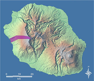
Du battant des lames au sommet des montagnes
Encyclopedia
French language
French is a Romance language spoken as a first language in France, the Romandy region in Switzerland, Wallonia and Brussels in Belgium, Monaco, the regions of Quebec and Acadia in Canada, and by various communities elsewhere. Second-language speakers of French are distributed throughout many parts...
for "From the beating of the waves to the summit of the mountains" (lit.) or "From the seashore to the mountaintops" (fig.)) is a French expression that formerly served to define the geographic concessions accorded by the French East India Company
French East India Company
The French East India Company was a commercial enterprise, founded in 1664 to compete with the British and Dutch East India companies in colonial India....
to the colonists of the island of Réunion
Réunion
Réunion is a French island with a population of about 800,000 located in the Indian Ocean, east of Madagascar, about south west of Mauritius, the nearest island.Administratively, Réunion is one of the overseas departments of France...
when it was still called île Bourbon. Since then, the expression has become a common phrase, indeed a "fixed formula". In its strictest meaning, it acts grammatically as an answer to the question "how?" and explains the way in which the land was cut into straight bands that stretch from the shore to the highest points without ever stretching horizontally. On the other hand, considered in its broader meaning, the expression substitutes for an adverb of place, being a synonym for "everywhere".
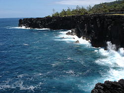
Lame
The island suffers from a geographical position that exposes it to strong waves with multiple origins. One of these is the trade wind
Trade wind
The trade winds are the prevailing pattern of easterly surface winds found in the tropics, within the lower portion of the Earth's atmosphere, in the lower section of the troposphere near the Earth's equator...
s and above all affects the leeward east coast. Another explanation is the absence of dry land between the south seas and the shores of the Sud sauvage (the southeastern part of the island), which means that the screaming sixties and the furious fifties (terms invented by mariners to describe the powerful winds between those longitudes) can reach Réunion without meeting any obstacle. A third reason is that this French Overseas department lies in the path of the tropical cyclone
Tropical cyclone
A tropical cyclone is a storm system characterized by a large low-pressure center and numerous thunderstorms that produce strong winds and heavy rain. Tropical cyclones strengthen when water evaporated from the ocean is released as the saturated air rises, resulting in condensation of water vapor...
s that arise in the centre of the Indian Ocean
Indian Ocean
The Indian Ocean is the third largest of the world's oceanic divisions, covering approximately 20% of the water on the Earth's surface. It is bounded on the north by the Indian Subcontinent and Arabian Peninsula ; on the west by eastern Africa; on the east by Indochina, the Sunda Islands, and...
.
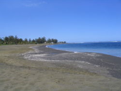
Battant des lames
The word battant as used here is not covered by any of the definitions given by the Trésor de la langue française informatisé. According to Le Français de la Réunion, a dictionary written by literature professor Michel Beniamino, this term in effect forms part of a noun phrase that takes on a particular meaning when it is associated with the word lames in the French spoken on Réunion. Thus, the battant des lames would be "the part of the coast subjected the action of the waves". Consequently, the meaning is close to what is called a foreshore in Metropolitan FranceMetropolitan France
Metropolitan France is the part of France located in Europe. It can also be described as mainland France or as the French mainland and the island of Corsica...
.
However, although Beniamino thinks that "seashore" is the best synonym, others consider that the terms are not equivalent. For instance, in a July 2002 dissertation written for the École supérieure des géomètres et topographes and titled Les Spécificités du bornage à l'île de la Réunion et leurs origines ("The Specifics of Partitioning on the Island of Réunion and Their Origins"), Yannick Smil posits that the seashore is less exposed to waves than the battant des lames.
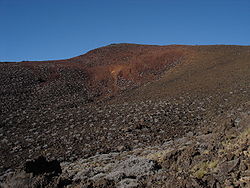
Au sommet des montagnes
Massif
In geology, a massif is a section of a planet's crust that is demarcated by faults or flexures. In the movement of the crust, a massif tends to retain its internal structure while being displaced as a whole...
s, that of Piton des Neiges
Piton des Neiges
The Piton des Neiges is a massive 3,069 m shield volcano on Réunion, one of the French volcanic islands in the Mascarene Archipelago in the southwestern Indian Ocean. It is located about east of Madagascar. Piton des Neiges is the highest point on Réunion and is considered to be the highest...
and of Piton de la Fournaise
Piton de la Fournaise
Piton de la Fournaise : "Peak of the Furnace" is a shield volcano on the eastern side of Réunion island in the Indian Ocean. It is currently one of the most active volcanoes in the world, along with Kīlauea in the Hawaiian Islands , Stromboli, Etna and Mount Erebus in Antarctica...
. However, the sommet meant by the original version is neither of these two peaks. Rather, Grand Bénare
Grand Bénare
The Grand Bénare is a volcanic peak on the island of Réunion, located in the Western part of the island, overlooking the "Cirque de Mafate" and "Cirque de Cilaos".It is the third highest peak on the island, after the Piton des Neiges and the Gros Morne....
was meant: when the expression was devised, it was far more familiar to the settlers.
At the time, in fact, neither of the former two peaks had been approached. According to Bory de Saint-Vincent
Jean Baptiste Bory de Saint-Vincent
Jean Baptiste Bory de Saint-Vincent was a French naturalist. He was born at Agen...
, the first ascent of the island's active volcano (de la Fournaise) came in the mid-18th century, while that of the extinct volcano (des Neiges) came even later. The expression itself dates to the beginnings of the island's colonisation, about a century earlier.
Original context
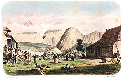
The exact origins of the expression have not been clearly established. However, it is certain that it was first used to designate the physical limits of the enormous parcels of land that the French East India Company granted to the French colonists who had just settled on the island's shores from the end of the 18th century. Thus, it is quite likely that it appeared in writing on the legal documents that the company had to draft in order to grant these concessions, a privilege that conferred upon it the status of royal factory.From the time Réunion started to be peopled, the island's entire territory was the property of the King. However, the first inhabitants settled wherever they liked, taking whatever land they wanted: there was room for everyone. It was only several years later that the East India Company expressed a desire to fix people's property lines so that they could cultivate the land more efficiently. Governor Vauboulon was the first to attempt to organise cultivation of the land and introduced the system of concessions. The first that can be found in the département archives date to 16 January 1690.
Logic behind the principle
Paris
Paris is the capital and largest city in France, situated on the river Seine, in northern France, at the heart of the Île-de-France region...
ian customary law that has guided the rights of succession. It stipulates that goods are to be divided equally among all heirs, regardless of relative age or sex.
Because the climate varied depending on altitude and thus there were differences in the potential value of the land, the property lines were drawn along the slope of the hills so as to benefit each descendant in a complete and equitable fashion: flat, easy-access land in the plains near the royal roads and the sea; land for farming and cultivation halfway up; and, a little higher, land planted with trees for building or burning. In turn, the intermediary level was divided in three parts, each with a distinct function: the lowest was used for subsistence farming
Subsistence agriculture
Subsistence agriculture is self-sufficiency farming in which the farmers focus on growing enough food to feed their families. The typical subsistence farm has a range of crops and animals needed by the family to eat and clothe themselves during the year. Planting decisions are made with an eye...
, the middle for coffee
Coffee
Coffee is a brewed beverage with a dark,init brooo acidic flavor prepared from the roasted seeds of the coffee plant, colloquially called coffee beans. The beans are found in coffee cherries, which grow on trees cultivated in over 70 countries, primarily in equatorial Latin America, Southeast Asia,...
plantations and the highest for animal husbandry
Animal husbandry
Animal husbandry is the agricultural practice of breeding and raising livestock.- History :Animal husbandry has been practiced for thousands of years, since the first domestication of animals....
.
The task of dividing plots perpendicular to the coast was made much easier by the fact that numerous ravines, difficult to cross, cover Réunion, starting from the heights and striating the sides of this cone-shaped island. Each lot might therefore be bounded by two torrents, as is the concession stretching from the shore to the mountain peaks that Governor Jacques de La Cour granted to Chauveau et Grimaud on 10 February 1699 between Ravine Saint-Gilles and Ravine des Sables. The downhill flow of the water forms nearly incontestable natural bounds for the property.
Problems on the shore
Disputes up high
Since ravines were often formed by the union of several thalwegThalweg
Thalweg in geography and fluvial geomorphology signifies the deepest continuous inline within a valley or watercourse system.-Hydrology:In hydrological and fluvial landforms, the thalweg is a line drawn to join the lowest points along the entire length of a stream bed or valley in its downward...
s upstream, the choice of which tributary to keep as the boundary marker between plots of land up high was not always easy and often led to disputes. This problem was aggravated by the fact that some of the ravines in question had several names, which made for a possible source of confusion.
The question of what was meant by au sommet des montagnes was the most hotly debated. Although its meaning was clear in the Saint-Paul
Saint-Paul, Réunion
Saint-Paul is the second-largest commune in the French overseas department of Réunion. It is located on the extreme west side of the island of Réunion.Until 1999, near Saint Paul there was the 428 metres tall mast OMEGA Chabrier transmitter.- Transport :...
region, where the planèze (gently inclined volcanic plateau
Volcanic plateau
A volcanic plateau is a plateau produced by volcanic activity. There are two main types: lava plateaus and pyroclastic plateaus.-Lava plateau:...
) is dominated by the Grand Bénare, the expression thereafter became a "style clause" used without any relation to the real situation in the regions where the landscape was more craggy. Thus, several possible meanings were debated:
- The point that seemed highest, as seen from the shore.
- The outside edge of the ridges of the cirqueCirqueCirque may refer to:* Cirque, a geological formation* Makhtesh, an erosional landform found in the Negev desert of Israel and Sinai of Egypt*Cirque , an album by Biosphere* Cirque Corporation, a company that makes touchpads...
s of MafateCirque de MafateThe Cirque de Mafate is a caldera on Réunion Island . It was formed from the collapse of the large shield volcano the Piton des Neiges....
, SalazieSalazieSalazie is a volcanic caldera and commune in the department and region of Réunion.The first settlement of the area took place in 1829 after a cyclone had devastated the nearby coast, and the municipality of Salazie was formed in 1889...
and CilaosCilaosCilaos is a town and commune on the French island of Réunion in the Indian Ocean. It is located centrally on the island, in a caldera of altitude 1214 m...
, the three depressions in the centre of the island. - The high point of the island, that is the summit of the Piton des Neiges.
La Plaine-des-Palmistes
La Plaine-des-Palmistes is a commune in the French overseas department of Réunion.-Geography:It lies in the eastern part of the island, on the RN3 road, south west of Saint-Benoît and northesast fo the Col de Bellevue. It is known for its nearby forest and for the Biberon Falls...
and of the Plaine des Cafres
Plaine des Cafres
La Plaine des Cafres is a plateau on Réunion Island, one of the French volcanic islands in the Mascarene Archipelago in the southwestern Indian Ocean...
, which happened in 1834. The farmers considered that their parcels extended up to the summit of the island's highest mountain, so that all the concessions met at a single point.
Since this latter interpretation did not correspond to the physical reality of the terrain, the administration created a new distinction between the expressions sommet des montagnes ("summit of the mountains") and sommet de la montagne ("summit of the mountain"), which it had hitherto used interchangeably. Thus, a judgment of the Conseil de contentieux administratif, issued 2 August 1853, defined the first as designating the high point as seen from several successive places, while the second referred only to the crest as seen in the foreground. A judgment of the Saint-Denis tribunal, issued 5 May 1856, then established that le sommet des montagnes was the crest in the background seen from the sea, and that there was no need to differentiate between use of the singular and the plural in the expression. This judgment was upheld by a ruling of the Cour de Bordeaux
Bordeaux
Bordeaux is a port city on the Garonne River in the Gironde department in southwestern France.The Bordeaux-Arcachon-Libourne metropolitan area, has a population of 1,010,000 and constitutes the sixth-largest urban area in France. It is the capital of the Aquitaine region, as well as the prefecture...
on 19 June 1867.
Several years later, a ruling of 25 February 1874 ordered the amicable delimitation
Boundary delimitation
Boundary delimitation, or simply delimitation, is the term used to describe the drawing of boundaries, but is most often used to describe the drawing of electoral boundaries, specifically those of precincts, states, counties or other municipalities...
of the line of separation forming the high point of the concessions. However, the delimitation of the parcels did not follow this judicially-ordered definition. It took an acquisition of summits by the government to put an end to the quarrel and fix the upper limit of the properties.
New units of measurement appear
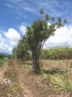
Dracaena reflexa
Dracaena reflexa, commonly called Pleomele or the Song of India, is a species of Dracaena which is a tropical tree native to Madagascar, Mauritius, and other nearby islands of the Indian Ocean...
, to make the boundaries visible and make them known to the neighbours.
The arpent
Arpent
An arpent is a unit of length and a unit of area. It is a pre-metric French unit based on the Roman actus. It is used in Quebec as well as in some areas of the United States that were part of French Louisiana.-Unit of length:...
(58.464 m), the unit of measurement employed in the first years of colonisation, fell out of use in several decades. In this context, new standards were ripe for appearance. Among these were the geometric footstep and above all the gaulette (4.872 m), an agrarian unit that continued to be used on a daily basis through the end of the 20th century.
Thinning, then concentrating private properties
Little by little as they were handed down, the strips of land became more and more narrow. Some were only a few metres wide by several kilometres long following the downward slope. Because of this, farming and access to parcels became more and more difficult.The pauperisation and relegation of part of the island's white population were due to the sugar crisis of the 1820s, '30s and '40s, and also to the growing irrationality of the smallholdings' shapes. This relegation led to the colonisation of the island's centre and of its cirques from 1830. The Petits Blancs des Hauts (poor, landless whites) were those areas' first permanent inhabitants after maroon
Maroon (people)
Maroons were runaway slaves in the West Indies, Central America, South America, and North America, who formed independent settlements together...
slaves.
However, the trend toward thinning the parcels was not universal. The vertical logic imposed by the formula of the East India Company was not immutable and rather quickly, in order to deal with demographic pressure, there started to appear horizontal boundaries cutting the original strips into several plots situated one above the other. In 1732, the surveyor Durongoüet was tasked with tracing four surveyors' lines parallel to the shore, at altitudes of 100, 200, 400 and 600 m. These lines, which correspond to the topographic notion of level curves, are still visible today, especially above the centre of Saint-Pierre
Saint-Pierre, Réunion
Saint-Pierre is the third-largest commune in the French overseas department of Réunion. It is located on the southwest side of the island of Réunion.-External links:*...
, in the southern part of the island. Today these are navigable roads lined with houses that form evocatively-named towns away from the centre: Ligne Paradis at around 100 m altitude, Ligne des Bambous
Ligne des Bambous
Ligne des Bambous is a village on the island of Réunion, located near its southern coast in the commune of Saint-Pierre....
at about 200 m, Ligne des Quatre-cents ("Line of the Four Hundreds") a little further and Ligne des Six-cents ("Line of the Six Hundreds") right at the top.
In addition, according to geographer Wilfrid Bertile, some owners, usually making multiple transactions, were able to merge several properties and so form large domains that encompassed key parts of the island's land. In the second half of the 19th century, land concentration became extreme, to the benefit of a handful of private owners like the Kerveguens and of the several banks, such as Crédit Foncier. These squires, whether private or institutional, thus gained thousands, indeed tens of thousands of hectares. This allowed some to consider that the application of the principle devised by the East India Company is what originated the control by ruling élites over all the lands of the island of Réunion.
Whatever the case may be, the system founded on private property ended up dominating at the expense of the concession-based system, which was further threatened by the development of the colonat partiaire, a form of metayage
Metayage
The Metayage system is the cultivation of land for a proprietor by one who receives a proportion of the produce, as a kind of sharecropping.-Origin and function:...
specific to the French outre-mer, inspired by slavery and not abolished until 2006. These new forms of land occupancy signalled, when the ensuing transactions were made, an approach of economic opportunism rather than geographic logic. It was thus that the carving up du battant des lames au sommet des montagnes inevitably started to ebb.
Initial carving up into communes
Roman Catholic Church
The Catholic Church, also known as the Roman Catholic Church, is the world's largest Christian church, with over a billion members. Led by the Pope, it defines its mission as spreading the gospel of Jesus Christ, administering the sacraments and exercising charity...
. The French Revolution
French Revolution
The French Revolution , sometimes distinguished as the 'Great French Revolution' , was a period of radical social and political upheaval in France and Europe. The absolute monarchy that had ruled France for centuries collapsed in three years...
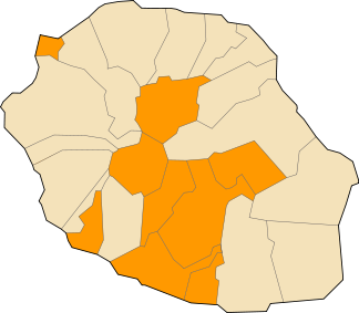
transformed these parishes into communes. For several decades, the latter possessed the specific shape of the first concessions. All stretched from the ocean to the summits until the end of the 19th century.
It took until 1882, when L'Entre-Deux was created, that the first commune of Réunion not stretching du battant des lames au sommet des montagnes was created: it did not reach the sea and its minimum altitude was around 100 m. France having become a republic, systematic hagiotoponymy (naming places after saints) was abandoned on that occasion. Thus, L'Entre-Deux became the first municipality whose name did not honour a saint.
Since then, several other communes not respecting the principle of vertical division have been created: L'Étang-Salé
L'Étang-Salé
L'Étang-Salé is a commune in the department and region of Réunion. It is bordered by the communes of Les Avirons and Saint-Louis. Within the commune is the Etang-Salé forest. There is also a beach with black sand in the commune....
, Petite-Île
Petite-Île
Petite-Île is a commune in the French island and department of Réunion. The commune is bordered by the communes of Saint-Joseph to the east and Saint-Pierre to the west...
, Le Port
Le Port, Réunion
Le Port is a commune in the French overseas department of Réunion. It is located at the extreme northwest corner of the island of Réunion. In the 1999 census, Le Port had a population of 38,412...
and Saint-Pierre do not reach the mountains, while Cilaos, La Plaine-des-Palmistes, Salazie and Le Tampon
Le Tampon
Le Tampon is the fourth-largest commune in the French overseas department of Réunion. It is located on the south-central part of the island of Réunion, adjacent to Saint-Pierre....
do not border the coast. Today, although a majority of communes stretch du battant des lames au sommet des montagnes, other conceptions of territorial division than that promoted by the East India Company's expression have made their mark on Réunion.
The traditional division of plots from seashore to centre has not prevented the differentiation of Réunion's territory into two qualitatively distinct zones. It has not stopped the development of a dualism between the island's Heights and lowlands, an opposition that the Parc national de la Réunion, opened at the beginning of 2007, tries to correct.
Equivalents elsewhere
For all the reasons already indicated, the expression ceased to be used in its original sense rather soon after it appeared. However, it serves to designate the whole of the island of Réunion just as other expressions, more or less historical, stand for the whole of a country or continent:- "From Dunkirk to Tamanrasset" for France, when AlgeriaAlgeriaAlgeria , officially the People's Democratic Republic of Algeria , also formally referred to as the Democratic and Popular Republic of Algeria, is a country in the Maghreb region of Northwest Africa with Algiers as its capital.In terms of land area, it is the largest country in Africa and the Arab...
was part of France - "From the AtlanticAtlantic OceanThe Atlantic Ocean is the second-largest of the world's oceanic divisions. With a total area of about , it covers approximately 20% of the Earth's surface and about 26% of its water surface area...
to the UralsUral MountainsThe Ural Mountains , or simply the Urals, are a mountain range that runs approximately from north to south through western Russia, from the coast of the Arctic Ocean to the Ural River and northwestern Kazakhstan. Their eastern side is usually considered the natural boundary between Europe and Asia...
" for Europe - "From CairoCairoCairo , is the capital of Egypt and the largest city in the Arab world and Africa, and the 16th largest metropolitan area in the world. Nicknamed "The City of a Thousand Minarets" for its preponderance of Islamic architecture, Cairo has long been a centre of the region's political and cultural life...
to Cape TownCape TownCape Town is the second-most populous city in South Africa, and the provincial capital and primate city of the Western Cape. As the seat of the National Parliament, it is also the legislative capital of the country. It forms part of the City of Cape Town metropolitan municipality...
" for Africa - "From AlaskaAlaskaAlaska is the largest state in the United States by area. It is situated in the northwest extremity of the North American continent, with Canada to the east, the Arctic Ocean to the north, and the Pacific Ocean to the west and south, with Russia further west across the Bering Strait...
to Tierra del FuegoTierra del FuegoTierra del Fuego is an archipelago off the southernmost tip of the South American mainland, across the Strait of Magellan. The archipelago consists of a main island Isla Grande de Tierra del Fuego divided between Chile and Argentina with an area of , and a group of smaller islands including Cape...
" for the Americas - "From BrestBrest, FranceBrest is a city in the Finistère department in Brittany in northwestern France. Located in a sheltered position not far from the western tip of the Breton peninsula, and the western extremity of metropolitan France, Brest is an important harbour and the second French military port after Toulon...
to VladivostokVladivostokThe city is located in the southern extremity of Muravyov-Amursky Peninsula, which is about 30 km long and approximately 12 km wide.The highest point is Mount Kholodilnik, the height of which is 257 m...
" for Eurasia - "From sea to shining seaAmerica the Beautiful"America the Beautiful" is an American patriotic song. The lyrics were written by Katharine Lee Bates and the music composed by church organist and choirmaster Samuel A. Ward....
" (from the PacificPacific OceanThe Pacific Ocean is the largest of the Earth's oceanic divisions. It extends from the Arctic in the north to the Southern Ocean in the south, bounded by Asia and Australia in the west, and the Americas in the east.At 165.2 million square kilometres in area, this largest division of the World...
to the Atlantic) for the United StatesUnited StatesThe United States of America is a federal constitutional republic comprising fifty states and a federal district...
Additionally, there are several non-geographical expressions that serve to evoke the totality of a physical entity by describing a bottom-up movement just like the East India Company's expression:
- "From the cellar to the attic" to describe a whole house
- "From the foundation to the roof" (De fond en comble) to describe the whole of a particular building.
Economy
The expression is particularly used by the local tourist industry in its advertising materials. The industry sees it as an easy way to encapsulate the special attraction of travelling to Réunion: access to the sea and the mountains in the same day.Literature
In a 1972 work, the poet Jean Albany wrote that "the mountain starts to rise from the beating of the waves".Several months later, Catherine Lavaux used the expression in the title of a work: La Réunion, du battant des lames au sommet des montagnes ("Réunion, from the beating of the waves to the summit of the mountains"). The work appeared in several editions, the latest in 1998.
Others
An exhibition called Le long du battant des lames ("Along the seashore") was opened by the Confrérie des gens de la mer in February 2004 at Saint-DenisSaint-Denis, Réunion
Saint-Denis is the préfecture of the French overseas region and department of Réunion, in the Indian Ocean. It is located at the island's northernmost point, close to the mouth of the Rivière Saint-Denis....
. It remained there until the beginning of 2007 before opening at the Musée Stella Matutina in Saint-Leu
Saint-Leu, Réunion
Saint-Leu is a commune in the French overseas department of Réunion. It is located on the west side of the island of Réunion.-Points of interest:* Conservatoire botanique national de Mascarin...
that March 31.