
DN postcode area
Encyclopedia
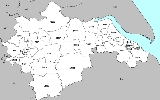
The DN postcode area, also known as the Doncaster postcode area, is a group of postcode districts around Barnetby
, Barrow upon Humber
, Barton-upon-Humber
, Brigg
, Cleethorpes
, Doncaster
, Gainsborough
, Goole
, Grimsby
, Immingham
, Retford
, Scunthorpe
and Ulceby
in England
.
The S64
postcode district was originally earmarked as the DN13 postcode district. On a map, a gap is formed in the geographic postcode pattern, which is why DN13 does not exist.
|-
! DN1
| DONCASTER
| Doncaster
town centre
| Doncaster
|-
! DN2
| DONCASTER
| Intake, Wheatley, Wheatley Hills
| Doncaster
|-
! DN3
| DONCASTER
| Armthorpe
, Barnby Dun, Branton, Edenthorpe
, Kirk Sandall
| Doncaster
|-
! DN4
| DONCASTER
| Balby
, Belle Vue, Bessacarr
, Cantley
, Hexthorpe
, Hyde Park
, Warmsworth
| Doncaster
|-
! DN5
| DONCASTER
| Arksey
, Barnburgh
, Bentley
, Cusworth, Harlington
, Scawsby, Scawthorpe, Sprotborough, Toll Bar
| Barnsley, Doncaster
|-
! DN6
| DONCASTER
| Adwick-le-Street, Askern
, Campsall, Moss
, Norton
, Sutton, Walden Stubbs
, Woodlands
| Doncaster, Selby
|-
! DN7
| DONCASTER
| Dunsville, Hatfield, Lindholme, Stainforth
| Doncaster
|-
! DN8
| DONCASTER
| Thorne
| Doncaster
|-
! DN9
| DONCASTER
| Epworth, Finningley
, Haxey
, Owston Ferry
| Doncaster, North Lincolnshire
, Belton
|-
! DN10
| DONCASTER
| Bawtry
, Misson
, Misterton
, Scrooby
| Bassetlaw
, Doncaster
|-
! DN11
| DONCASTER
| Harworth
, New Rossington
, Rossington
, Tickhill
, Wadworth
| Bassetlaw, Doncaster
|-
! DN12
| DONCASTER
| Conisbrough
, Denaby Main, New Edlington, Old Denaby, Old Edlington
| Doncaster, Rotherham
|-
! DN14
| GOOLE
| Goole
, Howden
, Rawcliffe
, Carlton
| East Riding of Yorkshire
, Selby
|-
! DN15
| SCUNTHORPE
| Alkborough
, Appleby
, Burton upon Stather
, Coleby
, Dragonby, Flixborough
, Flixborough Ind Estate, Foxhills Ind Estate, Gunness
, High Risby, High Santon, Low Risby, Low Santon, Normanby, Roxby
, Scunthorpe
, Thealby, West Halton
, Whitton
, Wintringham
, Winterton
| North Lincolnshire
|-
! DN16
| SCUNTHORPE
| Bottesford
, Holme
, Queensway Ind Estate, Raventhorpe, Scunthorpe
, Twigmoor
| North Lincolnshire
|-
! DN17
| SCUNTHORPE
| Althorpe
, Amcotts, Bottesford Moor, Bottesford
, Crowle, Derrythorpe, Ealand
, East Butterwick
, Eastoft
, Garthorpe, Gunness
, Keadby
, Luddington
, Messingham
, North Ewster, Scunthorpe
, Susworth, West Butterwick
, Yaddlethorpe
| North Lincolnshire
|-
! DN18
| BARTON-UPON-HUMBER
|
| North Lincolnshire
|-
! DN19
| BARROW-UPON-HUMBER
|
| North Lincolnshire
|-
! DN20
| BRIGG
| Brigg
, Broughton
, Hibaldstow
, Scawby
, Wrawby
| North Lincolnshire
|-
! DN21
| GAINSBOROUGH
| Gainsborough
, Kirton Lindsey, Marton
, Lea
, Blyton
, Scotter
| West Lindsey
|-
! DN22
| RETFORD
| Ranskill
, Retford
| Bassetlaw
|-
! DN31
| GRIMSBY
|
| North East Lincolnshire
|-
! DN32
| GRIMSBY
|
| North East Lincolnshire
|-
! DN33
| GRIMSBY
|
| North East Lincolnshire
|-
! DN34
| GRIMSBY
|
| North East Lincolnshire
|-
! DN35
| CLEETHORPES
| Cleethorpes
| North East Lincolnshire
|-
! DN36
| GRIMSBY
| Holton le Clay, Humberston
, Ludborough
, Marshchapel
, New Waltham
, North Cotes, North Thoresby
, Tetney
| East Lindsey
, North East Lincolnshire
|-
! DN37
| GRIMSBY
| Ashby cum Fenby
, Barnoldby-le-Beck, Beelsby
, Bradley
, Brocklesby
, Great Coates
, Great Limber
, Irby-upon-Humber
, Laceby
, Waltham
| North East Lincolnshire, West Lindsey
|-
! DN38
| BARNETBY
| Barnetby
, Grasby
, Searby
, Somerby
| North Lincolnshire, West Lindsey
|-
! DN39
| ULCEBY
| Croxton
, Kirmington
, Ulceby
, Wootton
| North Lincolnshire
|-
! DN40
| IMMINGHAM
| North Killingholme
, South Killingholme
, Habrough
, Immingham
, East Halton
| North Lincolnshire, North East Lincolnshire
|-
! DN41
| GRIMSBY
| Healing
, Keelby
, Stallingborough
| North East Lincolnshire, West Lindsey
|}
Barnetby
Barnetby is a village and civil parish in North Lincolnshire, England, between Scunthorpe and Grimsby. According to the 2001 census it had a population of 1,593. Barnetby railway station serves the village and surrounding area...
, Barrow upon Humber
Barrow upon Humber
Barrow upon Humber is a village and civil parish in North Lincolnshire, England. Many of the buildings in the centre of the village are of 18th and 19th century origin. There are several buildings of note including Down Hall, Barrow Hall, Forester's Hall and West Cote Farm. There are two public...
, Barton-upon-Humber
Barton-upon-Humber
Barton-upon-Humber or Barton is a small town and civil parish in North Lincolnshire, England located on the south bank of the Humber Estuary, and at the end of the Humber Bridge. It lies east of Leeds, southwest of Hull and north northeast of the county town of Lincoln...
, Brigg
Brigg
Brigg is a small market town in North Lincolnshire, England, with a population of 5,076 in 2,213 households . The town lies at the junction of the River Ancholme and east-west transport routes across northern Lincolnshire...
, Cleethorpes
Cleethorpes
Cleethorpes is a town and unparished area in North East Lincolnshire, England, situated on the estuary of the Humber. It has a population of 31,853 and is a seaside resort.- History :...
, Doncaster
Doncaster
Doncaster is a town in South Yorkshire, England, and the principal settlement of the Metropolitan Borough of Doncaster. The town is about from Sheffield and is popularly referred to as "Donny"...
, Gainsborough
Gainsborough, Lincolnshire
Gainsborough is a town 15 miles north-west of Lincoln on the River Trent within the West Lindsey district of Lincolnshire, England. At one time it served as an important port with trade downstream to Hull, and was the most inland in England, being more than 55 miles from the North...
, Goole
Goole
Goole is a town, civil parish and port located approximately inland on the confluence of the rivers Don and Ouse in the East Riding of Yorkshire, England...
, Grimsby
Grimsby
Grimsby is a seaport on the Humber Estuary in Lincolnshire, England. It has been the administrative centre of the unitary authority area of North East Lincolnshire since 1996...
, Immingham
Immingham
Immingham is a town in North East Lincolnshire, located on the south bank of the Humber Estuary...
, Retford
Retford
Retford is a market town in Nottinghamshire in the East Midlands of England, located 31 miles from the city of Nottingham, and 23 miles west of Lincoln, in the district of Bassetlaw. The town is situated in a valley with the River Idle and the Chesterfield Canal running through the centre of the...
, Scunthorpe
Scunthorpe
Scunthorpe is a town within North Lincolnshire, England. It is the administrative centre of the North Lincolnshire unitary authority, and had an estimated total resident population of 72,514 in 2010. A predominantly industrial town, Scunthorpe, the United Kingdom's largest steel processing centre,...
and Ulceby
Ulceby, North Lincolnshire
Ulceby is a village, civil parish and Post town of North Lincolnshire in EnglandUlceby is situated on the eastern side of North Lincolnshire roughly equidistant to Grimsby and Scunthorpe. Ulceby is a rural village surrounded by fields, forests, farms and nearby villages such as Kirmington, Wootton...
in England
England
England is a country that is part of the United Kingdom. It shares land borders with Scotland to the north and Wales to the west; the Irish Sea is to the north west, the Celtic Sea to the south west, with the North Sea to the east and the English Channel to the south separating it from continental...
.
The S64
S postcode area
The S postcode area, also known as the Sheffield postcode area, is a group of postcode districts around Barnsley, Chesterfield, Dronfield, Hope Valley, Mexborough, Rotherham, Sheffield and Worksop in England....
postcode district was originally earmarked as the DN13 postcode district. On a map, a gap is formed in the geographic postcode pattern, which is why DN13 does not exist.
Coverage
The approximate coverage of the postcode districts:|-
! DN1
| DONCASTER
| Doncaster
Doncaster
Doncaster is a town in South Yorkshire, England, and the principal settlement of the Metropolitan Borough of Doncaster. The town is about from Sheffield and is popularly referred to as "Donny"...
town centre
| Doncaster
|-
! DN2
| DONCASTER
| Intake, Wheatley, Wheatley Hills
Wheatley Hills
Wheatley Hills is an urban suburb of Doncaster located a mile outside of the town centre in South Yorkshire, England.-Sport:North 1 East Rugby Union team, Wheatley Hills RUFC are named in conjunction with the suburb. They are based at Brunnel Road in the York Road Industrial Estate just outside...
| Doncaster
|-
! DN3
| DONCASTER
| Armthorpe
Armthorpe
Armthorpe is a village and civil parish which forms the eastern edge of the Doncaster urban sprawl within the Metropolitan Borough of Doncaster, South Yorkshire, England. It has a population of 12,630.-Etymology:...
, Barnby Dun, Branton, Edenthorpe
Edenthorpe
Edenthorpe is a village and civil parish in the east of the Metropolitan Borough of Doncaster in the English county of South Yorkshire. It has a population of 4,752.-Geography:...
, Kirk Sandall
| Doncaster
|-
! DN4
| DONCASTER
| Balby
Balby
Balby is a suburb of Doncaster located to the south-west of the borough in the north of England. It is home to the former secondary school, now sports college Balby Carr...
, Belle Vue, Bessacarr
Bessacarr
Bessacarr is a large village, located in the south-east of Doncaster, South Yorkshire, England. It is one of the most affluent areas in the region. Due, in part, to its respected reputation, Bessacarr has expanded hugely since the Second World War, and is now one of the largest villages in the...
, Cantley
Cantley, South Yorkshire
Cantley is a civil parish in the Metropolitan Borough of Doncaster in South Yorkshire, England. It has a population of 2,830.-Early history:...
, Hexthorpe
Hexthorpe
Hexthorpe is a small village located on the edge of the town of Doncaster. Hexthorpe lies in the Metropolitan Borough of Doncaster, South Yorkshire, England. The area's shape resembles a rhombus, with borders with Balby and Doncaster Town Centre, separated by railway lines and the river separating...
, Hyde Park
Hyde Park, South Yorkshire
Hyde Park is a district in Sheffield, England. The area is named after fields that occupied the area in the early 19th century.The area was used for cricket matches between 1824 and 1856. It had space for up to 10 cricket matches at a time...
, Warmsworth
Warmsworth
Warmsworth is a village and civil parish in the Metropolitan Borough of Doncaster in South Yorkshire, England. It has a population of 3,855. The main route to Warmsworth is the A1 and the A630. The River Don also runs next to Warmsworth, as well as a train line from Doncaster to Sheffield...
| Doncaster
|-
! DN5
| DONCASTER
| Arksey
Arksey
Arksey is a village in the Metropolitan Borough of Doncaster in South Yorkshire, England.It is well known to most in Doncaster and the villagers for its level-railway crossing. The barriers can be down for upto nine hours a day when all durations are added together frustrating many people and...
, Barnburgh
Barnburgh
Barnburgh is a village and civil parish in the Metropolitan Borough of Doncaster in South Yorkshire, England. The village is adjacent to the village of Harlington - the parish contains both villages, and according to the 2001 census it had a population of 1,979...
, Bentley
Bentley, South Yorkshire
Bentley is a village in South Yorkshire, England two miles north of the town of Doncaster.The village was once owned by Edmund Hastings of Plumtree, Nottinghamshire, who had inherited it from his wife Copley's Sprotborough family...
, Cusworth, Harlington
Harlington, South Yorkshire
Harlington is a village in the civil parish of Barnburgh in the Metropolitan Borough of Doncaster in South Yorkshire, England. The village lies less than a mile from the adjoining village of Barnburgh and the parish contains both villages. According to the 2001 census, Harlington had a population...
, Scawsby, Scawthorpe, Sprotborough, Toll Bar
| Barnsley, Doncaster
|-
! DN6
| DONCASTER
| Adwick-le-Street, Askern
Askern
Askern is a town and civil parish within the Metropolitan Borough of Doncaster, in South Yorkshire, England. It is on the A19 road between Doncaster and Selby. It became a spa town in the late 19th century, but this stopped once coal mines opened in the town. The last mine closed in the 1990s...
, Campsall, Moss
Moss, South Yorkshire
Moss is a village and civil parish in the Metropolitan Borough of Doncaster in South Yorkshire, England. It has a population of 290.-References:...
, Norton
Norton, Doncaster
Norton is a civil parish in the Metropolitan Borough of Doncaster , on the border with North Yorkshire. The northern boundary of the parish is marked by the River Went, while the Great North Road forms the western boundary...
, Sutton, Walden Stubbs
Walden Stubbs
Walden Stubbs is a little village and civil parish in the Selby district of North Yorkshire, England. Situated close to the border with South Yorkshire, and north of Doncaster. It lies close to the River Went, which starts at Featherstone. The Askern Branch Line runs through this village, which...
, Woodlands
Woodlands, South Yorkshire
Woodlands is a model village, 3 miles north of Doncaster in South Yorkshire, England. It was designed and built in the early 20th century by Percy Bond Houfton as tied cottages for the miners of the neighbouring Brodsworth Colliery...
| Doncaster, Selby
Selby (district)
Selby is a local government district of North Yorkshire, England. The local authority, Selby District Council, is based in the town of Selby and provides services to an area which includes Tadcaster and a host of villages....
|-
! DN7
| DONCASTER
| Dunsville, Hatfield, Lindholme, Stainforth
Stainforth, South Yorkshire
Stainforth is a small town and civil parish in the Metropolitan Borough of Doncaster, in South Yorkshire, England. It is located roughly north-east of Doncaster, close to Hatfield and Thorne. It has a population of 6,342.-Etymology:...
| Doncaster
|-
! DN8
| DONCASTER
| Thorne
| Doncaster
|-
! DN9
| DONCASTER
| Epworth, Finningley
Finningley
Finningley is a village and civil parish within the Metropolitan Borough of Doncaster, in South Yorkshire, England. Historically part of Nottinghamshire, Finningley lies along the A614 road, about six miles from the centre of Doncaster, at , and at an elevation of around seven metres above sea...
, Haxey
Haxey
Haxey is a village and civil parish within North Lincolnshire, England. It is situated to the northwest of the city of Lincoln and in 2001 had a total resident population of 4,359....
, Owston Ferry
Owston Ferry
Owston Ferry is a village and civil parish in North Lincolnshire, England. It lies on the west bank of the River Trent, north of Gainsborough, and has a total resident population of 1,128....
| Doncaster, North Lincolnshire
North Lincolnshire
North Lincolnshire is a unitary authority area in the region of Yorkshire and the Humber in England. For ceremonial purposes it is part of Lincolnshire....
, Belton
Belton, North Lincolnshire
Belton is a village and civil parish in the Isle of Axholme area of North Lincolnshire, England, that lies on the A161 road six miles east from Scunthorpe. To the north of Belton is the town of Crowle; to the south, the village of Epworth....
|-
! DN10
| DONCASTER
| Bawtry
Bawtry
Bawtry is a small market town and civil parish which lies at the point where the Great North Road crosses the River Idle in the Metropolitan Borough of Doncaster in South Yorkshire, England. Nearby towns include Gainsborough to the east, Retford south southeast, Worksop to the southwest and...
, Misson
Misson, Nottinghamshire
Misson is a village in Nottinghamshire, England. It is located 12 miles north of Retford, and not directly accessible from the rest of Nottinghamshire. Misson Springs, which lie north of the village itself, is the northenmost place within the county...
, Misterton
Misterton, Nottinghamshire
Misterton is a village and civil parish in the Bassetlaw district of Nottinghamshire, England.-Geography:Misterton is located in the far north-east of both Bassetlaw and Nottinghamshire between Walkeringham to the South and Haxey to the North. The East of the village is bordered by the River...
, Scrooby
Scrooby
Scrooby is a small village, on the River Ryton and near Bawtry, in the northern part of the English county of Nottinghamshire. At the time of the 2001 census it had a population of 329. Until 1766, it was on the Great North Road so became a stopping-off point for numerous important figures...
| Bassetlaw
Bassetlaw
Bassetlaw is the northernmost district of Nottinghamshire, England, with a population according to the 2001 UK census of 107,713. The borough is predominantly rural, with two towns: Worksop, site of the borough offices, and Retford...
, Doncaster
|-
! DN11
| DONCASTER
| Harworth
Harworth
Harworth is a small town in the county of Nottinghamshire, in the Midlands of England in Bassetlaw district. It is approximately eight miles north of Worksop...
, New Rossington
Rossington
Rossington is a civil parish and former mining village in the Metropolitan Borough of Doncaster in South Yorkshire, England and is surrounded by countryside and the market towns of Bawtry and Tickhill.-Geography:...
, Rossington
Rossington
Rossington is a civil parish and former mining village in the Metropolitan Borough of Doncaster in South Yorkshire, England and is surrounded by countryside and the market towns of Bawtry and Tickhill.-Geography:...
, Tickhill
Tickhill
Tickhill is a small, wealthy town and civil parish in the Metropolitan Borough of Doncaster in South Yorkshire, England, on the border with Nottinghamshire. It has a population of 5,301.-Geography:...
, Wadworth
Wadworth
Wadworth is a village and civil parish in the Metropolitan Borough of Doncaster in South Yorkshire, England. It has a population of 1,229. Notable buildings in the village include Wadworth Hall.-References:...
| Bassetlaw, Doncaster
|-
! DN12
| DONCASTER
| Conisbrough
Conisbrough
Conisbrough is a town within the Metropolitan Borough of Doncaster, in South Yorkshire, England. It is located roughly midway between Doncaster and Rotherham, and is built alongside the River Don at...
, Denaby Main, New Edlington, Old Denaby, Old Edlington
| Doncaster, Rotherham
|-
! DN14
| GOOLE
| Goole
Goole
Goole is a town, civil parish and port located approximately inland on the confluence of the rivers Don and Ouse in the East Riding of Yorkshire, England...
, Howden
Howden
Howden is a small market town and civil parish in the East Riding of Yorkshire, England. It lies north of the M62, on the A614 road about north of Goole and south-west of York. William the Conqueror gave the town to the Bishops of Durham in 1080...
, Rawcliffe
Rawcliffe, East Riding of Yorkshire
Rawcliffe is a village and civil parish in the East Riding of Yorkshire, England. It is situated approximately west of Goole...
, Carlton
Carlton, Selby
Carlton is a village and civil parish in the Selby district of North Yorkshire, England. It is situated approximately south east of the town of Selby on the A1041.According to the 2001 UK census, Carlton parish had a population of 1,829....
| East Riding of Yorkshire
East Riding of Yorkshire
The East Riding of Yorkshire, or simply East Yorkshire, is a local government district with unitary authority status, and a ceremonial county of England. For ceremonial purposes the county also includes the city of Kingston upon Hull, which is a separate unitary authority...
, Selby
Selby (district)
Selby is a local government district of North Yorkshire, England. The local authority, Selby District Council, is based in the town of Selby and provides services to an area which includes Tadcaster and a host of villages....
|-
! DN15
| SCUNTHORPE
| Alkborough
Alkborough
Alkborough is a village of about 455 people in North Lincolnshire, England, located near the northern end of The Cliff range of hills overlooking the Humber Estuary at the Trent Falls, the confluence of the River Trent and the River Ouse....
, Appleby
Appleby, North Lincolnshire
Appleby is a small village in North Lincolnshire, England. It lies about 5 km to the north-east of Scunthorpe, on the B1207.Appleby population in the 2001 census returns is shown as 597....
, Burton upon Stather
Burton upon Stather
Burton-upon-Stather is a village and civil parish in North Lincolnshire, England. The village lies 5 miles north from Scunthorpe, 5 miles north-west from Frodingham, and is near the east bank of the River Trent...
, Coleby
Coleby, North Lincolnshire
Coleby is a hamlet in the civil parish of West Halton in North Lincolnshire, England, situated half a mile south-west of West Halton, approximately 7 miles north of Scunthorpe....
, Dragonby, Flixborough
Flixborough
Flixborough is a village and civil parish in North Lincolnshire, England. It is situated near to the River Trent, about 3 miles north-west of Scunthorpe. The village is noted for the 1974 Flixborough disaster....
, Flixborough Ind Estate, Foxhills Ind Estate, Gunness
Gunness
Gunness is a civil parish and small village situated on the east bank of the River Trent and deriving its name from forming a ness or promontory in the River Trent....
, High Risby, High Santon, Low Risby, Low Santon, Normanby, Roxby
Roxby, Lincolnshire
Roxby is a village in North Lincolnshire, England, about north of Scunthorpe and south-east from Winterton on the A1077. Roxby stands on a prominent part of the Lincoln Cliff and overlooks the Humber Estuary....
, Scunthorpe
Scunthorpe
Scunthorpe is a town within North Lincolnshire, England. It is the administrative centre of the North Lincolnshire unitary authority, and had an estimated total resident population of 72,514 in 2010. A predominantly industrial town, Scunthorpe, the United Kingdom's largest steel processing centre,...
, Thealby, West Halton
West Halton
West Halton is a village and civil parish in North Lincolnshire, England, situated north-west of Winterton, approximately north of Scunthorpe, and south of the Humber Estuary.The parish also contains part of Coleby, a small hamlet south of the village...
, Whitton
Whitton, North Lincolnshire
Whitton is an English village and civil parish of about 170 inhabitants in North Lincolnshire. It is located at the northern termination of the Cliff range of hills, on the south shore of the Humber, about below Trent Falls, and west of Barton-upon-Humber...
, Wintringham
Wintringham
Wintringham is a village and civil parish in the Ryedale district of North Yorkshire, England. It is near the A64 road and east of Malton.The Yorkshire Wolds Way National Trail and the Centenary Way, long distance footpaths pass through the village...
, Winterton
Winterton, Lincolnshire
Winterton is a small town in North Lincolnshire, England, north-east of Scunthorpe. Taking into account the five years since the last UK census, the population currently stands at approximately 4,700 people. Major north-south/east-west streets of Winterton are Market Street and Northlands Road...
| North Lincolnshire
|-
! DN16
| SCUNTHORPE
| Bottesford
Bottesford, North Lincolnshire
Bottesford is a small town and civil parish in North Lincolnshire, England. It is joined to southern Scunthorpe, and is defined by the B1501 road to the north and Bottesford Beck to the south. The River Trent lies to the west, with a boundary line approximately along Grammar School Walk, Richmond...
, Holme
Holme, Lincolnshire
Holme is a linear settlement and civil parish in North Lincolnshire, England.Holme is located some south-east of the town of Scunthorpe. Just to the south-east is Grade II listed Twigmoor Hall. This house was the home of John Wright before he was executed for his part in the Gunpowder Plot. The...
, Queensway Ind Estate, Raventhorpe, Scunthorpe
Scunthorpe
Scunthorpe is a town within North Lincolnshire, England. It is the administrative centre of the North Lincolnshire unitary authority, and had an estimated total resident population of 72,514 in 2010. A predominantly industrial town, Scunthorpe, the United Kingdom's largest steel processing centre,...
, Twigmoor
| North Lincolnshire
|-
! DN17
| SCUNTHORPE
| Althorpe
Althorpe
Althorpe is a small village lying on the A18 four miles west of Scunthorpe, in North Lincolnshire, England. To the west of Althorpe is the town of Crowle.-Geography:...
, Amcotts, Bottesford Moor, Bottesford
Bottesford, North Lincolnshire
Bottesford is a small town and civil parish in North Lincolnshire, England. It is joined to southern Scunthorpe, and is defined by the B1501 road to the north and Bottesford Beck to the south. The River Trent lies to the west, with a boundary line approximately along Grammar School Walk, Richmond...
, Crowle, Derrythorpe, Ealand
Ealand
Ealand is a small village in North Lincolnshire, England. It lies within the Isle of Axholme, south-east of Crowle, and north of the junction between the A161 and the A18....
, East Butterwick
East Butterwick
East Butterwick is a village in North Lincolnshire, England. It lies in the Isle of Axholme, about north-east from Epworth and north from Owston Ferry, on the eastern bank of the River Trent opposite its neighbour West Butterwick....
, Eastoft
Eastoft
Eastoft is a village and civil parish in North Lincolnshire, England. It lies within the Isle of Axholme, north-east of Crowle on the A161.The 2001 census recorded a parish population of 378.-History:...
, Garthorpe, Gunness
Gunness
Gunness is a civil parish and small village situated on the east bank of the River Trent and deriving its name from forming a ness or promontory in the River Trent....
, Keadby
Keadby
Keadby is a small village lying just off the A18, west of Scunthorpe, in North Lincolnshire, England. It lies on the West bank of the River Trent. It is pronounced "Kidby"....
, Luddington
Luddington, North Lincolnshire
Luddington is a village, part of the civil parish of Luddington with Haldenby, on the Isle of Axholme in North Lincolnshire, England. The nearest towns are Scunthorpe, Goole and Doncaster.-Early history:...
, Messingham
Messingham
Messingham is a small village outside Scunthorpe in North Lincolnshire, England. Messingham has a population of over about 4,000 people.-Geography:...
, North Ewster, Scunthorpe
Scunthorpe
Scunthorpe is a town within North Lincolnshire, England. It is the administrative centre of the North Lincolnshire unitary authority, and had an estimated total resident population of 72,514 in 2010. A predominantly industrial town, Scunthorpe, the United Kingdom's largest steel processing centre,...
, Susworth, West Butterwick
West Butterwick
West Butterwick is a village and civil parish in North Lincolnshire, England. It lies in the Isle of Axholme, about north-east from Epworth and north from Owston Ferry, on the western bank of the River Trent opposite its neighbour East Butterwick....
, Yaddlethorpe
Yaddlethorpe
Yaddlethorpe is a district in the south of Scunthorpe in North Lincolnshire, England close to the M180 in the DN17 postcode area. It is next to Bottesford, divided by the A159 road. The local secondary school is the South Leys School on Enderby Road. is on Park Avenue...
| North Lincolnshire
|-
! DN18
| BARTON-UPON-HUMBER
|
| North Lincolnshire
|-
! DN19
| BARROW-UPON-HUMBER
|
| North Lincolnshire
|-
! DN20
| BRIGG
| Brigg
Brigg
Brigg is a small market town in North Lincolnshire, England, with a population of 5,076 in 2,213 households . The town lies at the junction of the River Ancholme and east-west transport routes across northern Lincolnshire...
, Broughton
Broughton, Lincolnshire
Broughton is a small town and civil parish situated on the Roman Ermine Street, in the North Lincolnshire district of Lincolnshire. England. The hamlet of Wressle is part of the parish....
, Hibaldstow
Hibaldstow
Hibaldstow is a village and civil parish on the B1206, south of Brigg and the M180, in North Lincolnshire, England. The deserted medieval village of Gainsthorpe is situated nearby.-History:...
, Scawby
Scawby
Scawby is a village and civil parish in North Lincolnshire, England. According to the 2001 census it had a population of 2,277. It is located south west of Brigg just off the A15 and A18. Scawby Brook, just outside Brigg, is also within the parish....
, Wrawby
Wrawby
Wrawby is a small village in North Lincolnshire east of Brigg and close to Humberside Airport on the A18. It is most notable for Wrawby Postmill....
| North Lincolnshire
|-
! DN21
| GAINSBOROUGH
| Gainsborough
Gainsborough, Lincolnshire
Gainsborough is a town 15 miles north-west of Lincoln on the River Trent within the West Lindsey district of Lincolnshire, England. At one time it served as an important port with trade downstream to Hull, and was the most inland in England, being more than 55 miles from the North...
, Kirton Lindsey, Marton
Marton, Lincolnshire
Marton is a small Lincolnshire village clustered round the point where the modern A156 crosses the ancient Roman road mentioned in the Antonine Itinerary....
, Lea
Lea, Lincolnshire
Lea is a small village and parish on the outskirts of Gainsborough, Lincolnshire. It is at the junction of the A156 and B1241, approximately 2 miles south of Gainsborough town centre and 14 miles north-west of Lincoln....
, Blyton
Blyton
Blyton is a village and civil parish within the West Lindsey district of Lincolnshire, England. It is north-east of Gainsborough. From Blyton the village of Laughton lies to the north, and Pilham to the south-east, while the course of the River Trent is nearby to the west.Blyton had a population...
, Scotter
Scotter
Scotter is a large village and civil parish in West Lindsey, Lincolnshire, England, situated between Scunthorpe and Gainsborough.-Geography:The A159 road, which connects the two towns, crosses the River Eau in the village...
| West Lindsey
West Lindsey
West Lindsey is a local government district in Lincolnshire, England.-History:The district was formed on 1 April 1974, from the urban districts of Gainsborough, Market Rasen, along with Caistor Rural District, Gainsborough Rural District and Welton Rural District...
|-
! DN22
| RETFORD
| Ranskill
Ranskill
Ranskill is a village and civil parish in the Bassetlaw district of Nottinghamshire with its nearest town being Retford approximately 5 miles south...
, Retford
Retford
Retford is a market town in Nottinghamshire in the East Midlands of England, located 31 miles from the city of Nottingham, and 23 miles west of Lincoln, in the district of Bassetlaw. The town is situated in a valley with the River Idle and the Chesterfield Canal running through the centre of the...
| Bassetlaw
|-
! DN31
| GRIMSBY
|
| North East Lincolnshire
North East Lincolnshire
North East Lincolnshire is a unitary authority in the Yorkshire and the Humber region of England, bordering the unitary authority of North Lincolnshire and the administrative county of Lincolnshire...
|-
! DN32
| GRIMSBY
|
| North East Lincolnshire
|-
! DN33
| GRIMSBY
|
| North East Lincolnshire
|-
! DN34
| GRIMSBY
|
| North East Lincolnshire
|-
! DN35
| CLEETHORPES
| Cleethorpes
Cleethorpes
Cleethorpes is a town and unparished area in North East Lincolnshire, England, situated on the estuary of the Humber. It has a population of 31,853 and is a seaside resort.- History :...
| North East Lincolnshire
|-
! DN36
| GRIMSBY
| Holton le Clay, Humberston
Humberston
Humberston is a large village and civil parish to the south of Cleethorpes, North East Lincolnshire...
, Ludborough
Ludborough
Ludborough is a village in the East Lindsey district of Lincolnshire, England. It lies at the end of the A18 road. Ludborough has a population of 760 people. The Prime Meridian passes to the east of the village....
, Marshchapel
Marshchapel
Marshchapel is a coastal village in Lincolnshire. It is approximately south-east of Grimsby and north-east of Louth. It includes the hamlets of West End and Eskham.It has a village store which doubles as a Post Office...
, New Waltham
New Waltham
New Waltham is a village and civil parish in North East Lincolnshire. It is located just south of Grimsby and Cleethorpes close to the A16 , and is situated between the villages of Waltham and Humberston. Previously part of Waltham parish, the parish of New Waltham was created in 1961...
, North Cotes, North Thoresby
North Thoresby
North Thoresby is a village in Lincolnshire situated between Louth and Grimsby, approximately from each with a population of 2,062 with 50.5% of the population being over 60....
, Tetney
Tetney
Tetney is a small village in the East Lindsey district of Lincolnshire, England, just west of the Prime Meridian.-Geography and amenities:The village is on the A1031 road, the Cleethorpes-Mablethorpe road, just south of Cleethorpes and Humberston...
| East Lindsey
East Lindsey
East Lindsey is a local government district in Lincolnshire, England. The council is based in Manby near Louth, and other major settlements in the district include Alford, Spilsby, Mablethorpe, Skegness, Horncastle and Chapel St Leonards....
, North East Lincolnshire
|-
! DN37
| GRIMSBY
| Ashby cum Fenby
Ashby cum Fenby
Ashby cum Fenby is a village and civil parish in North East Lincolnshire, England, 4 miles south-west from Holton le Clay.In the 2001 census the population was recorded as 248. The village was recorded in the Domesday Book....
, Barnoldby-le-Beck, Beelsby
Beelsby
Beelsby is a village in North East Lincolnshire, England. The village lies 8 miles south-east of Grimsby.Beelsby population at the 2001 census was 114.The Grade II listed village church is dedicated to St...
, Bradley
Bradley, Lincolnshire
Bradley is a village and civil parish in North East Lincolnshire, England. It lies 3 miles west of Grimsby and 2 miles north of Barnoldby le Beck. Its population recorded in the 2001 census was 198....
, Brocklesby
Brocklesby
Brocklesby is a village and civil parish in the West Lindsey district of Lincolnshire, England. The village is 1 mile south of Habrough, 4 miles southwest of Immingham, close to the border of both North Lincolnshire and North East Lincolnshire, and near Humberside International Airport...
, Great Coates
Great Coates
Great Coates is a village and civil parish in North East Lincolnshire, England. It is to the north-west of the Grimsby urban area, and is served by Great Coates railway station...
, Great Limber
Great Limber
Great Limber is a village and civil parish in the West Lindsey district of Lincolnshire, England. It lies on the A18, west of Grimsby and east of Brigg....
, Irby-upon-Humber
Irby upon Humber
Irby upon Humber or Irby-on-Humber is a small village and civil parish in North East Lincolnshire, England. The village is situated on the A46 road south-west of Laceby....
, Laceby
Laceby
Laceby is a village in North East Lincolnshire, England, located on the A46 road just outside the western boundary of Grimsby. The main feature of the village is the 15th century Anglican parish church.-History:...
, Waltham
Waltham, Lincolnshire
Waltham is a village and civil parish in North East Lincolnshire, England. It is south-west of Grimsby and is close to the villages of Scartho, Brigsley, Barnoldby-le-Beck, and Bradley...
| North East Lincolnshire, West Lindsey
|-
! DN38
| BARNETBY
| Barnetby
Barnetby
Barnetby is a village and civil parish in North Lincolnshire, England, between Scunthorpe and Grimsby. According to the 2001 census it had a population of 1,593. Barnetby railway station serves the village and surrounding area...
, Grasby
Grasby
Grasby is a small village in the Lincolnshire Wolds, a designated Area of Outstanding Natural Beauty northwest of the town of Caistor, Lincolnshire, England....
, Searby
Searby, Lincolnshire
Searby is a village in the civil parish of Searby cum Owmby, nestled between the villages of Somerby and Grasby, about south east of the town of Brigg, and about north east of the town of Caistor, Lincolnshire, England...
, Somerby
| North Lincolnshire, West Lindsey
|-
! DN39
| ULCEBY
| Croxton
Croxton, Lincolnshire
Croxton is a civil parish in North Lincolnshire, England. It lies just south of the A180, north-west of Kirmington and west from Immingham.In the 2001 census the parish had a population of 36....
, Kirmington
Kirmington
Kirmington is a village in North Lincolnshire, England with a population of 337 .It is alongside the A18 road close to Humberside International Airport and borders with Habrough and Brocklesby, between Scunthorpe and Grimsby.Eastern Airways has its head office in the Schiphol House on the grounds...
, Ulceby
Ulceby, North Lincolnshire
Ulceby is a village, civil parish and Post town of North Lincolnshire in EnglandUlceby is situated on the eastern side of North Lincolnshire roughly equidistant to Grimsby and Scunthorpe. Ulceby is a rural village surrounded by fields, forests, farms and nearby villages such as Kirmington, Wootton...
, Wootton
| North Lincolnshire
|-
! DN40
| IMMINGHAM
| North Killingholme
North Killingholme
North Killingholme is a small village and civil parish in North Lincolnshire, England. It has a population of 224. Along with its larger neighbour South Killingholme, it makes up the area of Killingholme. It is slightly closer to Grimsby than to Scunthorpe...
, South Killingholme
South Killingholme
South Killingholme is a village in North Lincolnshire, England. It is divided by the A160 dual carriageway. Considerably larger than its neighbour, North Killingholme, together they make up the area of Killingholme...
, Habrough
Habrough
Habrough is a village in North East Lincolnshire, England. Habrough railway station serves the village and the town of Immingham. The name Habrough is found in many old records as "Haburgh"....
, Immingham
Immingham
Immingham is a town in North East Lincolnshire, located on the south bank of the Humber Estuary...
, East Halton
East Halton
East Halton is a small village and civil parish in North Lincolnshire, England, close to the Humber Estuary. It is from Immingham and north of the neighbouring village of North Killingholme.The 2001 census recorded a population of 604 people,...
| North Lincolnshire, North East Lincolnshire
|-
! DN41
| GRIMSBY
| Healing
Healing, Lincolnshire
Healing is a village and civil parish in North East Lincolnshire, England. It lies between Stallingborough and Great Coates, and to the west from Grimsby. Its population at the 2001 census was 2,606....
, Keelby
Keelby
Keelby is a village in the county of Lincolnshire, England, near the seaports of Immingham and Grimsby. It is located near the local Humberside Airport and the main road running alongside the village is the A18....
, Stallingborough
Stallingborough
Stallingborough is a village and civil parish in North East Lincolnshire, a short distance from both Grimsby and Immingham. The parish stretches from Lincolnshire to the Humber coast, and includes the hamlet of Little London.-Geography:...
| North East Lincolnshire, West Lindsey
|}