
Alkborough
Encyclopedia
Alkborough is a village of about 455 people in North Lincolnshire
, England, located near the northern end of The Cliff range of hills overlooking the Humber Estuary at the Trent Falls, the confluence of the River Trent
and the River Ouse
.
Alkborough, with the hamlet of Walcot about a mile (1.6 km) south, forms a civil parish which covers about 2875 acres (12 km²).
The village of Alkborough was once thought to be the location that the Romans
called Aquis but this name is now usually associated with the town of Buxton
in Derbyshire
(Aquis Arnemetiae).
of Lincolnshire
for centuries, from a very early time, Alkborough formed part of the Manley Wapentake in the North division of Lindsey
.
Care for the poor of the parish extends back prior to 1765, though after the Poor Law
reforms of 1834
, Alkborough became part of the Glanford Brigg Poor Law Union.
From 1894 until 1974, Alkborough lay within Glanford Brigg Rural District
.
.
, known as The Cliff, which runs roughly north/south. The steep mudstone escarpment is to the west, with a shallow slope to the east formed from shale of the Lower Lias
in the Jurassic
system.
farmland of nearly 990 acres (4 km²) situated at the "Confluence of the Rivers" (Trent Falls
) where the Rivers Trent
and Ouse
join to form the Humber
estuary
. The alluvial plain
and is now jointly owned by the UK's Environment Agency and English Nature
. Flood
defences which were built in the 1950s to protect the area have been breached to allow water to reclaim the land at high tide and in times of flooding. The project created 495 acres (2 km²) of new intertidal habitat in the inner part of the Humber estuary
. The new grassland will be managed to encourage biodiversity
, with reedbeds, lagoon
s and grazing
areas.
Alkborough Flats is the first coastal realignment site to be developed as part of the Humber
Shore
line Management Plan. This "managed retreat
" strategy should lessen the risks of flooding in low-lying towns along the Ouse and Trent by realigning existing flood defenses to create compensatory intertidal habitat around the estuary.
situated to the south of Alkborough, and within the same Parish
.
. Eminson translates this as 'the ridge-like cliff above the mooring pool of the river'. The village's name goes through various spellings such as Alchebarue, Hautebarg, Alke Bere and Awkeburgh. Mills translates the village's name as 'wood or grave of a man called Alca'.
Professor Cameron thought the name Alkborough meant 'Al(u)ca's hill' from an Old English personal name, and he derived Walcot from 'the cottage, hut or shelter of the Welshman'. He suggested that the name might represent an isolated group of Welshmen, identifiable as such in Anglo-Saxon England.
period (4000 BC-2351 BC).
(2350 BC-1501 BC), were unearthed in 1920, in the grounds of Walcot Hall.
, Alkborough lay within the territory of the Corieltauvi tribe.
of the area, some time after AD43, the local Corieltauvi tribe became a Roman civitas
.
Pottery sherds dating from the 1st to the fourth century AD have been found in the fields south of Countess Close. These finds, along with a pot containing a small hoard of Roman coins, which was unearthed in the grounds of Walcot Hall, indicate the possibility of a Romano-British
Settlement here. A geophysical survey taken in 2003 showed clear evidence of a Romano-British ladder settlement.
. It was founded before 1052 (when it is recorded as being given by its founder, Thorold, High Sheriff
of the County of Lincoln, to Spalding Priory
). It was a small priory, having a cell of only three monks, a secular chaplain
, and a prior
. The abbey was dependent on Spalding Priory from 1052 to 1074, and then became an Alien priory
until 1220.
It was located at 53.683481°N 0.667179°W, which is in the south of the village in the grounds of College Farm. A Field Investigator's comment from 17 February 1964 states that there is no material evidence of antiquity.
Alkborough Priory is included in the National Monuments Record (NMR Number: SE 82 SE 7, Monument Number: 61223).
during World War II
. The following is a summary of an oral history
provided by an Alkborough resident who was school age during World War II:
The southern observation post was located at
53.689761°N 0.662059°W, and the northern at
53.697792°N 0.655185°W. They are both accessible to the public via a public footpath. The location of the chalk target marker is not known exactly, but was somewhere to the west of the new bird hide
, which is located at
53.695063°N 0.660376°W.
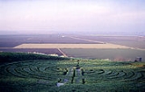
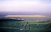 Close to the Cliff edge is Julian's Bower
, a unicursal turf maze
, 43 feet (13 m) across, of indeterminate age. Although referred to as a maze, being unicursal (having only one way in and one path through) it is more accurately a labyrinth
.
According to Arthur Mee's book Lincolnshire the maze was cut by monks in the 12th century, but White's Lincolnshire Directory of 1872 maintains that it was constructed in Roman
times as part of a game. Others think that while the feature is of Roman origin, it was later used by the Medieval Church for some sort of penitential purpose and only reverted to its former use as an amusement or diversion, after the Reformation
.
Firm documentary evidence of its existence only seems to date from 1697 however, when it was noticed, on his travels, by the Yorkshire
antiquary Abraham de la Pryme
.
In case the maze becomes overgrown or otherwise indistinct, its pattern is recorded, in a 19th century stained glass
church window, on the floor of the church porch
and also on the gravestone of James Goulton Constable, which is in Alkborough cemetery
.
Julian's Bower is a Scheduled Ancient Monument
.
(NLSMR) no. 44) is a rectangular earthwork lying a few yards to the south of Julian's Bower
. It measures approx. 80m x 90m internally.
It was recorded by the 18th century Antiquary, William Stukeley
on a visit to the area whilst researching his book Itinerarium Curiosum (or Observations From A Journey). He thought Countess Close to be a Roman Fort
, as did the earlier Abraham de la Pryme
. However, a 2003 archaeological project carried out by Humber Field Archaeology concluded that, despite evidence of a Romano-British
ladder settlement running south along the ridge from Countess Close, it is probable that the earthwork is the remains of a Medieval fortified manor house.
It is thought that Countess Close is named for a Saxon heiress called Countess Lucy of Leicester
, Lincoln and Chester
. She inherited the land from her husband Ivo Taillebois (who in the time of William the Conqueror was Lord of Holland), who was given the land by Peterborough Abbey. Following Lucy’s death, Countess Close passed to her son, who then gave the land to Spalding Priory
in 1147.
Countess close is a Scheduled Ancient Monument
.
The font, although set on a modern base, dates back to Norman
times.
The oak Reredos
behind the Altar was hand made by the famous Robert (Mouseman) Thompson (also known as Mousey Thompson) of Kilburn
. His signature mouse can be seen on the right hand upright. The Reredos was placed in the church as a memorial in the early 1920s.
Under a capping stone set in the floor near the tower entrance, lies what is believed to be a stone of Romano-British
origin.
of the church, bearing the following inscription:
which can be translated as:
suggesting that three of the four knights who murdered Thomas Becket
in Canterbury Cathedral
in 1170, (namely Sir Hugh de Morville, Lord of Westmorland
, Sir William de Tracy
and Sir Richard le Breton
), took refuge in Alkborough and helped with restoration of the church. If any such stone ever existed, it cannot now be found.
at Alkborough was built circa 1860 of red brick and tar, originally for the milling
of cereals. It replaced a post mill
which was recorded as still standing in 1853. It remained in wind operation until 1916 (but continued with engine operation for a short while thereafter), and from 2009 became part of a private dwelling. The mill retains two millstones in situ on the first floor. The floors contain re-used timber from the post mill, and two posts are made from a common sail whip.
The tower mill is included in the National Monuments Record (NMR Number: SE 883 215, Monument Number: 497747). It is located just off West Halton Lane at 53.682821°N 0.664474°W.
that discharges from a point just below the top of The Cliff escarpment, west of Walcot. However, due to Danish influence the name is not uncommon for springs in eastern England, keld being a Danish word for spring pool.
The waters of the spring were once believed to have had petrifying
properties, but if this were ever the case those properties are now lost. However, the spring is chalybeate
. Kell Well was first recorded by Abraham de la Pryme following his visit in 1697. He wrote:
The stones to which De la Pryme referred were the remnants of fossil crinoids. These were once common at Kell Well, though there have been no recorded finds for many years.
Kell Well is accessible to the public via a spur path from the nearby bridleway. It is located at 53.675810°N 0.679078°W
Thompson states that However, in an article written for the local Parish Magazine
, local resident Edna Barnard argued that, (from discussions with an ex-horseman,)
In the same article, reference to Low Wells in the Parish Enclosure Award of 1768 is also cited.
Low Wells is accessible to the public from Prospect Lane, and is located at 53.686635°N 0.666337°W
light known as Apex Light lies within the parish. This is despite it being 'attached' to the opposite bank of the River Trent
, and inaccessible from Alkborough.
It is located at 53.700376°N 0.691336°W
North Lincolnshire
North Lincolnshire is a unitary authority area in the region of Yorkshire and the Humber in England. For ceremonial purposes it is part of Lincolnshire....
, England, located near the northern end of The Cliff range of hills overlooking the Humber Estuary at the Trent Falls, the confluence of the River Trent
River Trent
The River Trent is one of the major rivers of England. Its source is in Staffordshire on the southern edge of Biddulph Moor. It flows through the Midlands until it joins the River Ouse at Trent Falls to form the Humber Estuary, which empties into the North Sea below Hull and Immingham.The Trent...
and the River Ouse
River Ouse, Yorkshire
The River Ouse is a river in North Yorkshire, England. The river is formed from the River Ure at Cuddy Shaw Reach near Linton-on-Ouse, about 6 miles downstream of the confluence of the River Swale with the River Ure...
.
Alkborough, with the hamlet of Walcot about a mile (1.6 km) south, forms a civil parish which covers about 2875 acres (12 km²).
The village of Alkborough was once thought to be the location that the Romans
Roman Empire
The Roman Empire was the post-Republican period of the ancient Roman civilization, characterised by an autocratic form of government and large territorial holdings in Europe and around the Mediterranean....
called Aquis but this name is now usually associated with the town of Buxton
Buxton
Buxton is a spa town in Derbyshire, England. It has the highest elevation of any market town in England. Located close to the county boundary with Cheshire to the west and Staffordshire to the south, Buxton is described as "the gateway to the Peak District National Park"...
in Derbyshire
Derbyshire
Derbyshire is a county in the East Midlands of England. A substantial portion of the Peak District National Park lies within Derbyshire. The northern part of Derbyshire overlaps with the Pennines, a famous chain of hills and mountains. The county contains within its boundary of approx...
(Aquis Arnemetiae).
Governance
Lying within the historic county boundariesHistoric counties of England
The historic counties of England are subdivisions of England established for administration by the Normans and in most cases based on earlier Anglo-Saxon kingdoms and shires...
of Lincolnshire
Lincolnshire
Lincolnshire is a county in the east of England. It borders Norfolk to the south east, Cambridgeshire to the south, Rutland to the south west, Leicestershire and Nottinghamshire to the west, South Yorkshire to the north west, and the East Riding of Yorkshire to the north. It also borders...
for centuries, from a very early time, Alkborough formed part of the Manley Wapentake in the North division of Lindsey
Lindsey
Lindsey was a unit of local government until 1974 in Lincolnshire, England, covering the northern part of the county. The Isle of Axholme, which is on the west side of the River Trent, has normally formed part of it...
.
Care for the poor of the parish extends back prior to 1765, though after the Poor Law
Poor Law
The English Poor Laws were a system of poor relief which existed in England and Wales that developed out of late-medieval and Tudor-era laws before being codified in 1587–98...
reforms of 1834
Poor Law Amendment Act 1834
The Poor Law Amendment Act 1834, sometimes abbreviated to PLAA, was an Act of the Parliament of the United Kingdom passed by the Whig government of Lord Melbourne that reformed the country's poverty relief system . It was an Amendment Act that completely replaced earlier legislation based on the...
, Alkborough became part of the Glanford Brigg Poor Law Union.
From 1894 until 1974, Alkborough lay within Glanford Brigg Rural District
Glanford Brigg Rural District
Glanford Brigg was a rural district in Lincolnshire, Parts of Lindsey from 1894 to 1974.It was formed under the Local Government Act 1894 from the Glanford Brigg rural sanitary district...
.
Population history (1801 - 2001)
| Year | Population |
| 1801 | 345 |
| 1811 | 368 |
| 1821 | 428 |
| 1831 | 467 |
| 1841 | 528 |
| 1851 | 468 |
| 1861 | 497 |
| 1871 | 487 |
| 1881 | 399 |
| 1891 | 427 |
| 1901 | 420 |
| 1911 | 418 |
| 1921 | 432 |
| 1931 | 397 |
| 1941 | N/A (World War II) |
| 1951 | 448 |
| 1961 | 470 |
| 1971 | 468 |
| 1981 | 482 |
| 1991 | 454 |
| 2001 | 455 |
Conservation Area
The older part of Alkborough, including Julian's Bower, Countess Close, and Walcot, lies within a Conservation AreaConservation Area (United Kingdom)
In the United Kingdom, the term Conservation Area nearly always applies to an area considered worthy of preservation or enhancement because of its special architectural or historic interest, "the character or appearance of which it is desirable to preserve or enhance," as required by the Planning ...
.
Geography
Alkborough is situated on an escarpment formed of Triassic MudstoneMudstone
Mudstone is a fine grained sedimentary rock whose original constituents were clays or muds. Grain size is up to 0.0625 mm with individual grains too small to be distinguished without a microscope. With increased pressure over time the platey clay minerals may become aligned, with the...
, known as The Cliff, which runs roughly north/south. The steep mudstone escarpment is to the west, with a shallow slope to the east formed from shale of the Lower Lias
Lias Group
The Lias Group or Lias is a lithostratigraphic unit found in a large area of western Europe, including the British Isles, the North Sea, the low countries and the north of Germany...
in the Jurassic
Jurassic
The Jurassic is a geologic period and system that extends from about Mya to Mya, that is, from the end of the Triassic to the beginning of the Cretaceous. The Jurassic constitutes the middle period of the Mesozoic era, also known as the age of reptiles. The start of the period is marked by...
system.
Alkborough Flats
Alkborough Flats is an area of low-lying arableArable land
In geography and agriculture, arable land is land that can be used for growing crops. It includes all land under temporary crops , temporary meadows for mowing or pasture, land under market and kitchen gardens and land temporarily fallow...
farmland of nearly 990 acres (4 km²) situated at the "Confluence of the Rivers" (Trent Falls
Trent Falls
Trent Falls is the name of the confluence of the River Ouse and the River Trent which forms the Humber in Yorkshire, England.Despite a training wall and a mini-lighthouse called 'Apex Light', navigation at Trent Falls is not simple...
) where the Rivers Trent
River Trent
The River Trent is one of the major rivers of England. Its source is in Staffordshire on the southern edge of Biddulph Moor. It flows through the Midlands until it joins the River Ouse at Trent Falls to form the Humber Estuary, which empties into the North Sea below Hull and Immingham.The Trent...
and Ouse
River Ouse, Yorkshire
The River Ouse is a river in North Yorkshire, England. The river is formed from the River Ure at Cuddy Shaw Reach near Linton-on-Ouse, about 6 miles downstream of the confluence of the River Swale with the River Ure...
join to form the Humber
Humber
The Humber is a large tidal estuary on the east coast of Northern England. It is formed at Trent Falls, Faxfleet, by the confluence of the tidal River Ouse and the tidal River Trent. From here to the North Sea, it forms part of the boundary between the East Riding of Yorkshire on the north bank...
estuary
Estuary
An estuary is a partly enclosed coastal body of water with one or more rivers or streams flowing into it, and with a free connection to the open sea....
. The alluvial plain
Alluvial plain
An alluvial plain is a relatively flat landform created by the deposition of sediment over a long period of time by one or more rivers coming from highland regions, from which alluvial soil forms...
and is now jointly owned by the UK's Environment Agency and English Nature
English Nature
English Nature was the United Kingdom government agency that promoted the conservation of wildlife, geology and wild places throughout England between 1990 and 2006...
. Flood
Flood
A flood is an overflow of an expanse of water that submerges land. The EU Floods directive defines a flood as a temporary covering by water of land not normally covered by water...
defences which were built in the 1950s to protect the area have been breached to allow water to reclaim the land at high tide and in times of flooding. The project created 495 acres (2 km²) of new intertidal habitat in the inner part of the Humber estuary
Estuary
An estuary is a partly enclosed coastal body of water with one or more rivers or streams flowing into it, and with a free connection to the open sea....
. The new grassland will be managed to encourage biodiversity
Biodiversity
Biodiversity is the degree of variation of life forms within a given ecosystem, biome, or an entire planet. Biodiversity is a measure of the health of ecosystems. Biodiversity is in part a function of climate. In terrestrial habitats, tropical regions are typically rich whereas polar regions...
, with reedbeds, lagoon
Lagoon
A lagoon is a body of shallow sea water or brackish water separated from the sea by some form of barrier. The EU's habitat directive defines lagoons as "expanses of shallow coastal salt water, of varying salinity or water volume, wholly or partially separated from the sea by sand banks or shingle,...
s and grazing
Grazing
Grazing generally describes a type of feeding, in which a herbivore feeds on plants , and also on other multicellular autotrophs...
areas.
Alkborough Flats is the first coastal realignment site to be developed as part of the Humber
Humber
The Humber is a large tidal estuary on the east coast of Northern England. It is formed at Trent Falls, Faxfleet, by the confluence of the tidal River Ouse and the tidal River Trent. From here to the North Sea, it forms part of the boundary between the East Riding of Yorkshire on the north bank...
Shore
Shore
A shore or shoreline is the fringe of land at the edge of a large body of water, such as an ocean, sea, or lake. In Physical Oceanography a shore is the wider fringe that is geologically modified by the action of the body of water past and present, while the beach is at the edge of the shore,...
line Management Plan. This "managed retreat
Managed retreat
In the context of coastal erosion, managed retreat allows an area that was not previously exposed to flooding by the sea to become flooded by removing coastal protection...
" strategy should lessen the risks of flooding in low-lying towns along the Ouse and Trent by realigning existing flood defenses to create compensatory intertidal habitat around the estuary.
Walcot
Walcot is an outlying hamletHamlet (place)
A hamlet is usually a rural settlement which is too small to be considered a village, though sometimes the word is used for a different sort of community. Historically, when a hamlet became large enough to justify building a church, it was then classified as a village...
situated to the south of Alkborough, and within the same Parish
Parish
A parish is a territorial unit historically under the pastoral care and clerical jurisdiction of one parish priest, who might be assisted in his pastoral duties by a curate or curates - also priests but not the parish priest - from a more or less central parish church with its associated organization...
.
History
Alkborough was listed as 'Alchebarge' in the Domesday BookDomesday Book
Domesday Book , now held at The National Archives, Kew, Richmond upon Thames in South West London, is the record of the great survey of much of England and parts of Wales completed in 1086...
. Eminson translates this as 'the ridge-like cliff above the mooring pool of the river'. The village's name goes through various spellings such as Alchebarue, Hautebarg, Alke Bere and Awkeburgh. Mills translates the village's name as 'wood or grave of a man called Alca'.
Professor Cameron thought the name Alkborough meant 'Al(u)ca's hill' from an Old English personal name, and he derived Walcot from 'the cottage, hut or shelter of the Welshman'. He suggested that the name might represent an isolated group of Welshmen, identifiable as such in Anglo-Saxon England.
Neolithic
The earliest evidence of settlement in the area has been found near Kell Well (a spring on the ridge to the north of Alkborough and the west of Walcot) in the form of a stone axe head, flint arrowheads and other finds thought to date from the NeolithicNeolithic
The Neolithic Age, Era, or Period, or New Stone Age, was a period in the development of human technology, beginning about 9500 BC in some parts of the Middle East, and later in other parts of the world. It is traditionally considered as the last part of the Stone Age...
period (4000 BC-2351 BC).
Bronze Age
Artifacts including a beaker, dating from the early Bronze AgeBronze Age
The Bronze Age is a period characterized by the use of copper and its alloy bronze as the chief hard materials in the manufacture of some implements and weapons. Chronologically, it stands between the Stone Age and Iron Age...
(2350 BC-1501 BC), were unearthed in 1920, in the grounds of Walcot Hall.
Iron Age
During the late Iron AgeIron Age
The Iron Age is the archaeological period generally occurring after the Bronze Age, marked by the prevalent use of iron. The early period of the age is characterized by the widespread use of iron or steel. The adoption of such material coincided with other changes in society, including differing...
, Alkborough lay within the territory of the Corieltauvi tribe.
Roman
Following Roman invasionRoman conquest of Britain
The Roman conquest of Britain was a gradual process, beginning effectively in AD 43 under Emperor Claudius, whose general Aulus Plautius served as first governor of Britannia. Great Britain had already frequently been the target of invasions, planned and actual, by forces of the Roman Republic and...
of the area, some time after AD43, the local Corieltauvi tribe became a Roman civitas
Civitas
In the history of Rome, the Latin term civitas , according to Cicero in the time of the late Roman Republic, was the social body of the cives, or citizens, united by law . It is the law that binds them together, giving them responsibilities on the one hand and rights of citizenship on the other...
.
Pottery sherds dating from the 1st to the fourth century AD have been found in the fields south of Countess Close. These finds, along with a pot containing a small hoard of Roman coins, which was unearthed in the grounds of Walcot Hall, indicate the possibility of a Romano-British
Romano-British
Romano-British culture describes the culture that arose in Britain under the Roman Empire following the Roman conquest of AD 43 and the creation of the province of Britannia. It arose as a fusion of the imported Roman culture with that of the indigenous Britons, a people of Celtic language and...
Settlement here. A geophysical survey taken in 2003 showed clear evidence of a Romano-British ladder settlement.
Medieval
The village was home to Alkborough Benedictine PrioryOrder of Saint Benedict
The Order of Saint Benedict is a Roman Catholic religious order of independent monastic communities that observe the Rule of St. Benedict. Within the order, each individual community maintains its own autonomy, while the organization as a whole exists to represent their mutual interests...
. It was founded before 1052 (when it is recorded as being given by its founder, Thorold, High Sheriff
High Sheriff
A high sheriff is, or was, a law enforcement officer in the United Kingdom, Canada and the United States.In England and Wales, the office is unpaid and partly ceremonial, appointed by the Crown through a warrant from the Privy Council. In Cornwall, the High Sheriff is appointed by the Duke of...
of the County of Lincoln, to Spalding Priory
Spalding Priory
Spalding Priory was a small Benedictine house in the town of Spalding, Lincolnshire. It was founded as a cell of Croyland Abbey, in 1052, by Leofric, Earl of Mercia and his wife, Godiva, Countess of Leicester. It was supported by Leofric's eldest son...
). It was a small priory, having a cell of only three monks, a secular chaplain
Chaplain
Traditionally, a chaplain is a minister in a specialized setting such as a priest, pastor, rabbi, or imam or lay representative of a religion attached to a secular institution such as a hospital, prison, military unit, police department, university, or private chapel...
, and a prior
Prior
Prior is an ecclesiastical title, derived from the Latin adjective for 'earlier, first', with several notable uses.-Monastic superiors:A Prior is a monastic superior, usually lower in rank than an Abbot. In the Rule of St...
. The abbey was dependent on Spalding Priory from 1052 to 1074, and then became an Alien priory
Alien priory
Alien priories were religious establishments in England, such as a monastery or convent, which were under the control of another religious house outside of England...
until 1220.
It was located at 53.683481°N 0.667179°W, which is in the south of the village in the grounds of College Farm. A Field Investigator's comment from 17 February 1964 states that there is no material evidence of antiquity.
Alkborough Priory is included in the National Monuments Record (NMR Number: SE 82 SE 7, Monument Number: 61223).
Wartime
Bombing range
Alkborough Flats was home to a bombing rangeBombing range
A bombing range is an area used for testing explosive ordnance and practicing to accurately direct them to the target. Bombing ranges are used for munitions that either explode or produce too much destruction to use at a shooting range, such as kinetic energy penetrators or very large caliber...
during World War II
World War II
World War II, or the Second World War , was a global conflict lasting from 1939 to 1945, involving most of the world's nations—including all of the great powers—eventually forming two opposing military alliances: the Allies and the Axis...
. The following is a summary of an oral history
Oral history
Oral history is the collection and study of historical information about individuals, families, important events, or everyday life using audiotapes, videotapes, or transcriptions of planned interviews...
provided by an Alkborough resident who was school age during World War II:
The southern observation post was located at
53.689761°N 0.662059°W, and the northern at
53.697792°N 0.655185°W. They are both accessible to the public via a public footpath. The location of the chalk target marker is not known exactly, but was somewhere to the west of the new bird hide
Bird hide
A bird hide is a shelter, often camouflaged, that is used to observe wildlife, especially birds, at close quarters. Although hides were once built chiefly as hunting aids, they are now commonly found in parks and wetlands for the use of bird watchers, ornithologists and other observers who do not...
, which is located at
53.695063°N 0.660376°W.
Defensive structures
A number of World War II defensive structures were also located in the Alkborough area, including:- Three searchlightSearchlightA searchlight is an apparatus that combines a bright light source with some form of curved reflector or other optics to project a powerful beam of light of approximately parallel rays in a particular direction, usually constructed so that it can be swiveled about.-Military use:The Royal Navy used...
batteries. One of these (Site 3) was located just west of Whitton Road, at 53.689205°N 0.660562°W. It was manned by 1 Troop of 323 Searchlight Battery from October 1941. It was established as part of a special deployment of searchlights to defend the Humber estuary, complimenting existing local searchlight batteries.). A typical installation of this type comprised a small ring ditchRing ditchIn archaeology, the term ring ditch refers to a regularly shaped circular or pennanular ditch cut. The term is most often used as a generic description in cases where there is no clear evidence for the function of the site: for instance where it has been ploughed flat and is known only as a...
(providing operators with some shelter during an air raidStrategic bombingStrategic bombing is a military strategy used in a total war with the goal of defeating an enemy nation-state by destroying its economic ability and public will to wage war rather than destroying its land or naval forces...
, a predictor emplacement (for calculating the height/range of aircraft), a light anti-aircraft machine gun pit, a generatorElectrical generatorIn electricity generation, an electric generator is a device that converts mechanical energy to electrical energy. A generator forces electric charge to flow through an external electrical circuit. It is analogous to a water pump, which causes water to flow...
and hutted accommodation for the crew. This site is included in the National Monuments Record (NMR Number: SE 82 SE 62, Monument Number: 1500984). - A heavy anti-aircraft battery. It was located just south of West Halton Lane (near Southdale Farm), at 53.676506°N 0.650367°W, and was listed as 'unarmed' in 1942. This site is included in the National Monuments Record (NMR Number: SE 82 SE 60, Monument Number: 1473341).
Julian's Bower
Julian's Bower
Julian's Bower or Julian Bower is a name which was given to turf mazes in several different parts of England. Only one of this name still exists, at Alkborough in North Lincolnshire...
, a unicursal turf maze
Turf maze
Historically, a turf maze is a labyrinth made by cutting a convoluted path into a level area of short grass, turf or lawn. Some had names such as Mizmaze, Troy Town, The Walls of Troy, Julian's Bower, or Shepherd's Race...
, 43 feet (13 m) across, of indeterminate age. Although referred to as a maze, being unicursal (having only one way in and one path through) it is more accurately a labyrinth
Labyrinth
In Greek mythology, the Labyrinth was an elaborate structure designed and built by the legendary artificer Daedalus for King Minos of Crete at Knossos...
.
According to Arthur Mee's book Lincolnshire the maze was cut by monks in the 12th century, but White's Lincolnshire Directory of 1872 maintains that it was constructed in Roman
Roman Empire
The Roman Empire was the post-Republican period of the ancient Roman civilization, characterised by an autocratic form of government and large territorial holdings in Europe and around the Mediterranean....
times as part of a game. Others think that while the feature is of Roman origin, it was later used by the Medieval Church for some sort of penitential purpose and only reverted to its former use as an amusement or diversion, after the Reformation
English Reformation
The English Reformation was the series of events in 16th-century England by which the Church of England broke away from the authority of the Pope and the Roman Catholic Church....
.
Firm documentary evidence of its existence only seems to date from 1697 however, when it was noticed, on his travels, by the Yorkshire
Yorkshire
Yorkshire is a historic county of northern England and the largest in the United Kingdom. Because of its great size in comparison to other English counties, functions have been increasingly undertaken over time by its subdivisions, which have also been subject to periodic reform...
antiquary Abraham de la Pryme
Abraham de la Pryme
Abraham de la Pryme was an English antiquary.Abraham de la Pryme was born to Huguenot parents, Matthias de la Pryme and Sarah Smague at Hatfield in 1671...
.
In case the maze becomes overgrown or otherwise indistinct, its pattern is recorded, in a 19th century stained glass
Stained glass
The term stained glass can refer to coloured glass as a material or to works produced from it. Throughout its thousand-year history, the term has been applied almost exclusively to the windows of churches and other significant buildings...
church window, on the floor of the church porch
Porch
A porch is external to the walls of the main building proper, but may be enclosed by screen, latticework, broad windows, or other light frame walls extending from the main structure.There are various styles of porches, all of which depend on the architectural tradition of its location...
and also on the gravestone of James Goulton Constable, which is in Alkborough cemetery
Cemetery
A cemetery is a place in which dead bodies and cremated remains are buried. The term "cemetery" implies that the land is specifically designated as a burying ground. Cemeteries in the Western world are where the final ceremonies of death are observed...
.
Julian's Bower is a Scheduled Ancient Monument
Scheduled Ancient Monument
In the United Kingdom, a scheduled monument is a 'nationally important' archaeological site or historic building, given protection against unauthorized change. The various pieces of legislation used for legally protecting heritage assets from damage and destruction are grouped under the term...
.
Countess Close
Countess Close (National Monument No. 32622; North Lincolnshire Sites and Monuments RecordSites and Monuments Record
Each County or Unitary Authority in the United Kingdom maintains a Sites and Monuments Record or SMR, consisting of a list of known archaeological sites. Many SMRs are now developing into much broader Historic Environment Records , including information on historic buildings and designed landscapes...
(NLSMR) no. 44) is a rectangular earthwork lying a few yards to the south of Julian's Bower
Julian's Bower
Julian's Bower or Julian Bower is a name which was given to turf mazes in several different parts of England. Only one of this name still exists, at Alkborough in North Lincolnshire...
. It measures approx. 80m x 90m internally.
It was recorded by the 18th century Antiquary, William Stukeley
William Stukeley
William Stukeley FRS, FRCP, FSA was an English antiquarian who pioneered the archaeological investigation of the prehistoric monuments of Stonehenge and Avebury, work for which he has been remembered as "probably... the most important of the early forerunners of the discipline of archaeology"...
on a visit to the area whilst researching his book Itinerarium Curiosum (or Observations From A Journey). He thought Countess Close to be a Roman Fort
Castra
The Latin word castra, with its singular castrum, was used by the ancient Romans to mean buildings or plots of land reserved to or constructed for use as a military defensive position. The word appears in both Oscan and Umbrian as well as in Latin. It may have descended from Indo-European to Italic...
, as did the earlier Abraham de la Pryme
Abraham de la Pryme
Abraham de la Pryme was an English antiquary.Abraham de la Pryme was born to Huguenot parents, Matthias de la Pryme and Sarah Smague at Hatfield in 1671...
. However, a 2003 archaeological project carried out by Humber Field Archaeology concluded that, despite evidence of a Romano-British
Romano-British
Romano-British culture describes the culture that arose in Britain under the Roman Empire following the Roman conquest of AD 43 and the creation of the province of Britannia. It arose as a fusion of the imported Roman culture with that of the indigenous Britons, a people of Celtic language and...
ladder settlement running south along the ridge from Countess Close, it is probable that the earthwork is the remains of a Medieval fortified manor house.
It is thought that Countess Close is named for a Saxon heiress called Countess Lucy of Leicester
Leicester
Leicester is a city and unitary authority in the East Midlands of England, and the county town of Leicestershire. The city lies on the River Soar and at the edge of the National Forest...
, Lincoln and Chester
Chester
Chester is a city in Cheshire, England. Lying on the River Dee, close to the border with Wales, it is home to 77,040 inhabitants, and is the largest and most populous settlement of the wider unitary authority area of Cheshire West and Chester, which had a population of 328,100 according to the...
. She inherited the land from her husband Ivo Taillebois (who in the time of William the Conqueror was Lord of Holland), who was given the land by Peterborough Abbey. Following Lucy’s death, Countess Close passed to her son, who then gave the land to Spalding Priory
Spalding Priory
Spalding Priory was a small Benedictine house in the town of Spalding, Lincolnshire. It was founded as a cell of Croyland Abbey, in 1052, by Leofric, Earl of Mercia and his wife, Godiva, Countess of Leicester. It was supported by Leofric's eldest son...
in 1147.
Countess close is a Scheduled Ancient Monument
Scheduled Ancient Monument
In the United Kingdom, a scheduled monument is a 'nationally important' archaeological site or historic building, given protection against unauthorized change. The various pieces of legislation used for legally protecting heritage assets from damage and destruction are grouped under the term...
.
St John the Baptist Church
Earliest records show a Church here in 1052, and the Tower is of typical Saxon design. The architecture of the Church shows there have been many changes to the building throughout its long history.The font, although set on a modern base, dates back to Norman
Norman dynasty
Norman dynasty is the usual designation for the family that were the Dukes of Normandy and the English monarchs which immediately followed the Norman conquest and lasted until the Plantagenet dynasty came to power in 1154. It included Rollo and his descendants, and from William the Conqueror and...
times.
The oak Reredos
Reredos
thumb|300px|right|An altar and reredos from [[St. Josaphat's Roman Catholic Church|St. Josaphat Catholic Church]] in [[Detroit]], [[Michigan]]. This would be called a [[retable]] in many other languages and countries....
behind the Altar was hand made by the famous Robert (Mouseman) Thompson (also known as Mousey Thompson) of Kilburn
Kilburn
Kilburn is an area of north west London, England, which is divided between three London Boroughs, Brent, Camden, and a small part in Westminster. The main thoroughfare running northwest-southeast is Kilburn High Road, part of the modern A5 road which forms the boundary between the boroughs of Brent...
. His signature mouse can be seen on the right hand upright. The Reredos was placed in the church as a memorial in the early 1920s.
Under a capping stone set in the floor near the tower entrance, lies what is believed to be a stone of Romano-British
Romano-British
Romano-British culture describes the culture that arose in Britain under the Roman Empire following the Roman conquest of AD 43 and the creation of the province of Britannia. It arose as a fusion of the imported Roman culture with that of the indigenous Britons, a people of Celtic language and...
origin.
Possible Thomas Becket connection
In 1697, Abraham de la Pryme reported the existence of a stone in the ruined chancelChancel
In church architecture, the chancel is the space around the altar in the sanctuary at the liturgical east end of a traditional Christian church building...
of the church, bearing the following inscription:
which can be translated as:
suggesting that three of the four knights who murdered Thomas Becket
Thomas Becket
Thomas Becket was Archbishop of Canterbury from 1162 until his murder in 1170. He is venerated as a saint and martyr by both the Roman Catholic Church and the Anglican Communion...
in Canterbury Cathedral
Canterbury Cathedral
Canterbury Cathedral in Canterbury, Kent, is one of the oldest and most famous Christian structures in England and forms part of a World Heritage Site....
in 1170, (namely Sir Hugh de Morville, Lord of Westmorland
Hugh de Morville, Lord of Westmorland
Sir Hugh de Morville was an Anglo-Norman knight who served King Henry II of England in the late 12th century. He is chiefly famous as one of the assassins of Thomas Becket, Archbishop of Canterbury in 1170...
, Sir William de Tracy
William de Tracy
Sir William de Tracy, Knt., was Lord of the Manor of Toddington, Gloucestershire, feudal Baron of Bradninch, near Exeter, and Lord of Moretonhampstead, Devon...
and Sir Richard le Breton
Richard le Breton
Sir Richard le Breton was one of the four knights who murdered Saint Thomas Becket.He was the son of Simon le Bret or Simon Brito of Sampford Brett in Somerset and a near neighbour of the FitzUrses of Williton...
), took refuge in Alkborough and helped with restoration of the church. If any such stone ever existed, it cannot now be found.
Alkborough tower mill
The tower millTower mill
A tower mill is a type of windmill which consists of a brick or stone tower, on top of which sits a roof or cap which can be turned to bring the sails into the wind....
at Alkborough was built circa 1860 of red brick and tar, originally for the milling
Mill (grinding)
A grinding mill is a unit operation designed to break a solid material into smaller pieces. There are many different types of grinding mills and many types of materials processed in them. Historically mills were powered by hand , working animal , wind or water...
of cereals. It replaced a post mill
Post mill
The post mill is the earliest type of European windmill. The defining feature is that the whole body of the mill that houses the machinery is mounted on a single vertical post, around which it can be turned to bring the sails into the wind. The earliest post mills in England are thought to have...
which was recorded as still standing in 1853. It remained in wind operation until 1916 (but continued with engine operation for a short while thereafter), and from 2009 became part of a private dwelling. The mill retains two millstones in situ on the first floor. The floors contain re-used timber from the post mill, and two posts are made from a common sail whip.
The tower mill is included in the National Monuments Record (NMR Number: SE 883 215, Monument Number: 497747). It is located just off West Halton Lane at 53.682821°N 0.664474°W.
Kell Well
Kell Well is a springSpring (hydrosphere)
A spring—also known as a rising or resurgence—is a component of the hydrosphere. Specifically, it is any natural situation where water flows to the surface of the earth from underground...
that discharges from a point just below the top of The Cliff escarpment, west of Walcot. However, due to Danish influence the name is not uncommon for springs in eastern England, keld being a Danish word for spring pool.
The waters of the spring were once believed to have had petrifying
Petrifying well
-Nature:If an object is placed into such a well and left there for a period of months or years the object acquires a stony exterior. At one time this property was believed to be a result of magic or witchcraft, but it is an entirely natural phenomenon and due to a process of evaporation and...
properties, but if this were ever the case those properties are now lost. However, the spring is chalybeate
Chalybeate
Chalybeate waters, also known as ferruginous waters, are mineral spring waters containing salts of iron.-Name:The word "chalybeate" is derived from the Latin word for steel, "chalybs", which follows from the Greek word "khalups"...
. Kell Well was first recorded by Abraham de la Pryme following his visit in 1697. He wrote:
The stones to which De la Pryme referred were the remnants of fossil crinoids. These were once common at Kell Well, though there have been no recorded finds for many years.
Kell Well is accessible to the public via a spur path from the nearby bridleway. It is located at 53.675810°N 0.679078°W
Low Wells
Low Wells is a spring that discharges from a point just the south side of Prospect Lane, north of (and several yards below) St John the Baptist Church. There is no evidence suggesting how the spring became known as "Low Wells", though its position below the level of the main part of the village would seem to suggest an obvious answer. The well takes the form of three low brick arches behind a long rectangular trough, into which the water flows. This well-structure is thought to have been constructed c.1850. As this arrangement was probably to facilitate the watering of livestock, a pump was installed nearby to tap the springs first and provide clean drinking water for villagers, though this has now gone. This well-structure is thought to have been constructed c.1850, and was restored in 1986.Thompson states that However, in an article written for the local Parish Magazine
Parish Magazine
A parish magazine is a periodical produced by and for an ecclesiastical parish, generally within the Anglican Church. It usually comprises a mixture of religious articles, community contributions and parish notices, including the previous month‘s christenings, marriages and funerals. Magazines...
, local resident Edna Barnard argued that, (from discussions with an ex-horseman,)
In the same article, reference to Low Wells in the Parish Enclosure Award of 1768 is also cited.
Low Wells is accessible to the public from Prospect Lane, and is located at 53.686635°N 0.666337°W
Apex Light
By a quirk of the Alkborough & Walcot Parish boundary, the Trent FallsTrent Falls
Trent Falls is the name of the confluence of the River Ouse and the River Trent which forms the Humber in Yorkshire, England.Despite a training wall and a mini-lighthouse called 'Apex Light', navigation at Trent Falls is not simple...
light known as Apex Light lies within the parish. This is despite it being 'attached' to the opposite bank of the River Trent
River Trent
The River Trent is one of the major rivers of England. Its source is in Staffordshire on the southern edge of Biddulph Moor. It flows through the Midlands until it joins the River Ouse at Trent Falls to form the Humber Estuary, which empties into the North Sea below Hull and Immingham.The Trent...
, and inaccessible from Alkborough.
It is located at 53.700376°N 0.691336°W