
Whitton, North Lincolnshire
Encyclopedia
Whitton is an English
village
and civil parish of about 170 inhabitants in North Lincolnshire
. It is located at the northern termination of the Cliff range of hills, on the south shore of the Humber
, about 3 miles (4.8 km) below Trent Falls
, and 9 miles (14.5 km) west of Barton-upon-Humber
. The parish is bounded on the west by Alkborough
, on the east by Winteringham
and, to the south, by West Halton
.
crossed the Humber northward in 71 AD; first as a military camp and then later as a Roman villa
, overlooking the river, with its temple a few yards to the east, where the Church now stands. It is perhaps possible that Whitton was a landing stage on the south bank for the Roman fort and civitas
of Petuaria
Parisorum at Brough
across the river. Roman Coins
of Claudius Gothicus (268-270 AD) and Constantine I (the Great) (309-337 AD) have been found in the fields.
Nikolaus Pevsner
tells us that the Church tower 're-uses massive blocks of Roman stone', but these blocks of millstone grit which are to be found in several local churches (for example neighbouring Winteringham
) may have been sailed down the Ouse
and the Humber
from York
where Roman buildings were being dismantled or may even have come from some sort of triumphal arch or structure (perhaps like the Arch of Constantine
), which might have stood at the end of Ermine Street
.
Whitton is mentioned in the Domesday book
in 1086 as land that belonged to Henry de Ferrers
. Mention is made of land for eight ploughs, Henry's man has another two and ten villans and 4 bordars have another 5 and of 300 acres (1.2 km²) of meadow. The land was valued at seven pounds.
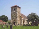
 The church, however is not mentioned in the Domesday survey. St. John the Baptist is a building of stone, dramatically situated overlooking the Humber
, consisting of a west tower, a small nave
( 6.7 m wide and 11.3 m long ) with a chancel
and a south vestry
attached. The partly Romanesque
(or Norman
) tower contains three, now untolled, bells; the third bell is said to have been brought from the village of Welton
, across the river, in Yorkshire
. The base of the tower forms a porch and the large tower arch
, leading into the nave, is thought to be Romanesque. The font
is also ancient and may be from the same period. The church seems to have been almost completely rebuilt in about 1797-8 when the elaborate crocket
ted pinnacle
s were removed from the top of the tower. A drawing, by Nattes
, of 1794 shows a dilapidated structure with a south aisle and a south porch.
The church was reseated in 1865 at the expense of Lady Strickland, and between about 1892 and 1897 the nave, chancel and roof were entirely rebuilt from the designs of W. & C. A. Bassett-Smith, architect
s, of London
. On the north side of the chancel are two stained-glass windows, erected in 1918 to the memory of Henry Spilman who was killed in the First World War. In 1952-3 cracks in the tower were repaired under the direction of A.R Haynes, architect of Brigg
.
The table, below right, shows the relative stability of the population, from the decennial census
figures.
England
England is a country that is part of the United Kingdom. It shares land borders with Scotland to the north and Wales to the west; the Irish Sea is to the north west, the Celtic Sea to the south west, with the North Sea to the east and the English Channel to the south separating it from continental...
village
Village
A village is a clustered human settlement or community, larger than a hamlet with the population ranging from a few hundred to a few thousand , Though often located in rural areas, the term urban village is also applied to certain urban neighbourhoods, such as the West Village in Manhattan, New...
and civil parish of about 170 inhabitants in North Lincolnshire
North Lincolnshire
North Lincolnshire is a unitary authority area in the region of Yorkshire and the Humber in England. For ceremonial purposes it is part of Lincolnshire....
. It is located at the northern termination of the Cliff range of hills, on the south shore of the Humber
Humber
The Humber is a large tidal estuary on the east coast of Northern England. It is formed at Trent Falls, Faxfleet, by the confluence of the tidal River Ouse and the tidal River Trent. From here to the North Sea, it forms part of the boundary between the East Riding of Yorkshire on the north bank...
, about 3 miles (4.8 km) below Trent Falls
Trent Falls
Trent Falls is the name of the confluence of the River Ouse and the River Trent which forms the Humber in Yorkshire, England.Despite a training wall and a mini-lighthouse called 'Apex Light', navigation at Trent Falls is not simple...
, and 9 miles (14.5 km) west of Barton-upon-Humber
Barton-upon-Humber
Barton-upon-Humber or Barton is a small town and civil parish in North Lincolnshire, England located on the south bank of the Humber Estuary, and at the end of the Humber Bridge. It lies east of Leeds, southwest of Hull and north northeast of the county town of Lincoln...
. The parish is bounded on the west by Alkborough
Alkborough
Alkborough is a village of about 455 people in North Lincolnshire, England, located near the northern end of The Cliff range of hills overlooking the Humber Estuary at the Trent Falls, the confluence of the River Trent and the River Ouse....
, on the east by Winteringham
Winteringham
Winteringham is a village in North Lincolnshire and on the south bank of the Humber Estuary, population 989 .The Romans had a settlement here probably called Ad Abum . The Roman road Ermine Street from London and Lincoln to the south crossed the Humber here by way of a ferry or ford to Brough, and...
and, to the south, by West Halton
West Halton
West Halton is a village and civil parish in North Lincolnshire, England, situated north-west of Winterton, approximately north of Scunthorpe, and south of the Humber Estuary.The parish also contains part of Coleby, a small hamlet south of the village...
.
History
Whitton may have originated at the time the RomansRoman Empire
The Roman Empire was the post-Republican period of the ancient Roman civilization, characterised by an autocratic form of government and large territorial holdings in Europe and around the Mediterranean....
crossed the Humber northward in 71 AD; first as a military camp and then later as a Roman villa
Roman villa
A Roman villa is a villa that was built or lived in during the Roman republic and the Roman Empire. A villa was originally a Roman country house built for the upper class...
, overlooking the river, with its temple a few yards to the east, where the Church now stands. It is perhaps possible that Whitton was a landing stage on the south bank for the Roman fort and civitas
Civitas
In the history of Rome, the Latin term civitas , according to Cicero in the time of the late Roman Republic, was the social body of the cives, or citizens, united by law . It is the law that binds them together, giving them responsibilities on the one hand and rights of citizenship on the other...
of Petuaria
Petuaria
Petuaria was originally a Roman fort situated where the town of Brough-on-Humber in the East Riding of Yorkshire now stands. Petuaria means something like 'quarter' or 'fourth part', incorporating the archaic Brythonic *petuar, 'four' .It was founded in 70 AD and abandoned in about 125...
Parisorum at Brough
Brough, East Riding of Yorkshire
Brough , or Brough-on-Humber, is a small town in the civil parish of Elloughton-cum-Brough in the East Riding of Yorkshire, England. The town has a population of around 7,000.-Location:...
across the river. Roman Coins
Roman currency
The Roman currency during most of the Roman Republic and the western half of the Roman Empire consisted of coins including the aureus , the denarius , the sestertius , the dupondius , and the as...
of Claudius Gothicus (268-270 AD) and Constantine I (the Great) (309-337 AD) have been found in the fields.
Nikolaus Pevsner
Nikolaus Pevsner
Sir Nikolaus Bernhard Leon Pevsner, CBE, FBA was a German-born British scholar of history of art and, especially, of history of architecture...
tells us that the Church tower 're-uses massive blocks of Roman stone', but these blocks of millstone grit which are to be found in several local churches (for example neighbouring Winteringham
Winteringham
Winteringham is a village in North Lincolnshire and on the south bank of the Humber Estuary, population 989 .The Romans had a settlement here probably called Ad Abum . The Roman road Ermine Street from London and Lincoln to the south crossed the Humber here by way of a ferry or ford to Brough, and...
) may have been sailed down the Ouse
River Ouse, Yorkshire
The River Ouse is a river in North Yorkshire, England. The river is formed from the River Ure at Cuddy Shaw Reach near Linton-on-Ouse, about 6 miles downstream of the confluence of the River Swale with the River Ure...
and the Humber
Humber
The Humber is a large tidal estuary on the east coast of Northern England. It is formed at Trent Falls, Faxfleet, by the confluence of the tidal River Ouse and the tidal River Trent. From here to the North Sea, it forms part of the boundary between the East Riding of Yorkshire on the north bank...
from York
York
York is a walled city, situated at the confluence of the Rivers Ouse and Foss in North Yorkshire, England. The city has a rich heritage and has provided the backdrop to major political events throughout much of its two millennia of existence...
where Roman buildings were being dismantled or may even have come from some sort of triumphal arch or structure (perhaps like the Arch of Constantine
Arch of Constantine
The Arch of Constantine is a triumphal arch in Rome, situated between the Colosseum and the Palatine Hill. It was erected to commemorate Constantine I's victory over Maxentius at the Battle of Milvian Bridge on October 28, 312...
), which might have stood at the end of Ermine Street
Ermine Street
Ermine Street is the name of a major Roman road in England that ran from London to Lincoln and York . The Old English name was 'Earninga Straete' , named after a tribe called the Earningas, who inhabited a district later known as Armingford Hundred, around Arrington, Cambridgeshire and Royston,...
.
Whitton is mentioned in the Domesday book
Domesday Book
Domesday Book , now held at The National Archives, Kew, Richmond upon Thames in South West London, is the record of the great survey of much of England and parts of Wales completed in 1086...
in 1086 as land that belonged to Henry de Ferrers
Henry de Ferrers
Henry de Ferrers was a Norman soldier from a noble family who took part in the conquest of England and is believed to have fought at the Battle of Hastings of 1066 and, in consequence, was rewarded with much land in the subdued nation.His elder brother William fell in the battle. William and Henri...
. Mention is made of land for eight ploughs, Henry's man has another two and ten villans and 4 bordars have another 5 and of 300 acres (1.2 km²) of meadow. The land was valued at seven pounds.
Humber
The Humber is a large tidal estuary on the east coast of Northern England. It is formed at Trent Falls, Faxfleet, by the confluence of the tidal River Ouse and the tidal River Trent. From here to the North Sea, it forms part of the boundary between the East Riding of Yorkshire on the north bank...
, consisting of a west tower, a small nave
Nave
In Romanesque and Gothic Christian abbey, cathedral basilica and church architecture, the nave is the central approach to the high altar, the main body of the church. "Nave" was probably suggested by the keel shape of its vaulting...
( 6.7 m wide and 11.3 m long ) with a chancel
Chancel
In church architecture, the chancel is the space around the altar in the sanctuary at the liturgical east end of a traditional Christian church building...
and a south vestry
Vestry
A vestry is a room in or attached to a church or synagogue in which the vestments, vessels, records, etc., are kept , and in which the clergy and choir robe or don their vestments for divine service....
attached. The partly Romanesque
Romanesque architecture
Romanesque architecture is an architectural style of Medieval Europe characterised by semi-circular arches. There is no consensus for the beginning date of the Romanesque architecture, with proposals ranging from the 6th to the 10th century. It developed in the 12th century into the Gothic style,...
(or Norman
Norman architecture
About|Romanesque architecture, primarily English|other buildings in Normandy|Architecture of Normandy.File:Durham Cathedral. Nave by James Valentine c.1890.jpg|thumb|200px|The nave of Durham Cathedral demonstrates the characteristic round arched style, though use of shallow pointed arches above the...
) tower contains three, now untolled, bells; the third bell is said to have been brought from the village of Welton
Welton, East Riding of Yorkshire
Welton is a village and civil parish in the East Riding of Yorkshire, England. It is situated approximately north of the town of Brough on the north side of the A63 road to Kingston upon Hull....
, across the river, in Yorkshire
Yorkshire
Yorkshire is a historic county of northern England and the largest in the United Kingdom. Because of its great size in comparison to other English counties, functions have been increasingly undertaken over time by its subdivisions, which have also been subject to periodic reform...
. The base of the tower forms a porch and the large tower arch
Arch
An arch is a structure that spans a space and supports a load. Arches appeared as early as the 2nd millennium BC in Mesopotamian brick architecture and their systematic use started with the Ancient Romans who were the first to apply the technique to a wide range of structures.-Technical aspects:The...
, leading into the nave, is thought to be Romanesque. The font
Baptismal font
A baptismal font is an article of church furniture or a fixture used for the baptism of children and adults.-Aspersion and affusion fonts:...
is also ancient and may be from the same period. The church seems to have been almost completely rebuilt in about 1797-8 when the elaborate crocket
Crocket
A crocket is a hook-shaped decorative element common in Gothic architecture. It is in the form of a stylised carving of curled leaves, buds or flowers which is used at regular intervals to decorate the sloping edges of spires, finials, pinnacles, and wimpergs....
ted pinnacle
Pinnacle
A pinnacle is an architectural ornament originally forming the cap or crown of a buttress or small turret, but afterwards used on parapets at the corners of towers and in many other situations. The pinnacle looks like a small spire...
s were removed from the top of the tower. A drawing, by Nattes
John Claude Nattes
John Claude Nattes c.1765-1839 was a watercolourist and topographical draughtsman of either French or English origin.In 1789 Sir Joseph Banks commissioned him to record the buildings of Lincolnshire and this resulted in more than 700 drawings and watercolours, made between 1789 and 1797, which...
, of 1794 shows a dilapidated structure with a south aisle and a south porch.
The church was reseated in 1865 at the expense of Lady Strickland, and between about 1892 and 1897 the nave, chancel and roof were entirely rebuilt from the designs of W. & C. A. Bassett-Smith, architect
Architect
An architect is a person trained in the planning, design and oversight of the construction of buildings. To practice architecture means to offer or render services in connection with the design and construction of a building, or group of buildings and the space within the site surrounding the...
s, of London
London
London is the capital city of :England and the :United Kingdom, the largest metropolitan area in the United Kingdom, and the largest urban zone in the European Union by most measures. Located on the River Thames, London has been a major settlement for two millennia, its history going back to its...
. On the north side of the chancel are two stained-glass windows, erected in 1918 to the memory of Henry Spilman who was killed in the First World War. In 1952-3 cracks in the tower were repaired under the direction of A.R Haynes, architect of Brigg
Brigg
Brigg is a small market town in North Lincolnshire, England, with a population of 5,076 in 2,213 households . The town lies at the junction of the River Ancholme and east-west transport routes across northern Lincolnshire...
.
The table, below right, shows the relative stability of the population, from the decennial census
Census in the United Kingdom
Coincident full censuses have taken place in the different jurisdictions of the United Kingdom every ten years since 1801, with the exceptions of 1941 and in both Northern Ireland and the Irish Free State in 1921; simultaneous censuses were taken in the Channel Islands and the Isle of Man, with...
figures.
| Year | Population | Year | Population | |
|---|---|---|---|---|
| 1801 | 207 | 1901 | 173 | |
| 1811 | 187 | 1911 | 167 | |
| 1821 | 212 | 1921 | 183 | |
| 1831 | 245 | 1931 | 196 | |
| 1841 | 217 | 1941 | N/A World War II World War II, or the Second World War , was a global conflict lasting from 1939 to 1945, involving most of the world's nations—including all of the great powers—eventually forming two opposing military alliances: the Allies and the Axis... |
|
| 1851 | 190 | 1951 | 173 | |
| 1861 | 215 | 1961 | 180 | |
| 1871 | 214 | 1971 | 136 | |
| 1881 | 201 | 1981 | 178 | |
| 1891 | 257 | 1991 | 173 | |