
Cyclone Percy
Encyclopedia
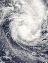
Cyclone Percy was the seventh named storm of the 2004-05 South Pacific cyclone season
and the fourth and final cyclone to form during the February 2005 outbreak in the South Pacific Ocean
.
Percy was also the most damaging of the February cyclones as it battered the Cook Islands
, which were still recovering from the impacts of Cyclones Meena, Nancy and Olaf
. Percy then devastated the island of Tokelau
, leaving many homeless and millions in dollars in property damages (although exact damage figures are unavailable). Because of warnings in anticipation of the storm, there were no deaths and there were only a few injuries.
on 23 February. The area of low pressure moved eastward, where it strengthened into Tropical Depression 10F a day later. Since the depression was located in an area of low wind shear
and warm water temperatures, it was able to quickly strengthen into Tropical Storm Percy. At this point in time, Percy was located 120 miles (193.1 km) east of Fongafale, Tuvalu
, and was moving towards the east-southeast at 14 kt (16 mph, 26 km/h). On 26 February, Percy reached Category 1
status, while located 400 miles (644 km) north of American Samoa
. While Percy moved east-southeast, a shortwave trough developed southwest of the storm. The trough caused the cyclone to intensify even further to a Category 3 storm as it passed between Fakaofa and Swains Island
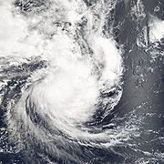
. Percy then reached Category 4 status north of Pago Pago as it winds reached over 135 mph (115 knots, 213 km/h) and the barometric pressure at its center fell to 925 millibars. On 27 February, Cyclone Percy encountered a high pressure ridge which slowed its forward speed. Because of this, the cyclone's structure became elliptical, which caused the cyclone to weaken back to Category 3 status. By 28 February, Percy bypassed the Pukapuka and Nassau Islands as a Category 3 cyclone as it continued to move east-southeast.
 By then, the cyclone was re-organizing as the storm steered to the southeast. On 2 March, Percy reached its second peak intensity. Its winds reached 160 mph (140 knots, 265 km/h) on the Saffir-Simpson Hurricane Scale
, and an estimated barometric pressure of 900 millibars. Cyclone Percy maintained Category 5 status for 18 hours, while located 110 mi (177 km) west of Palmerston Island
. After reaching Category 5 status, Percy began to weaken, due to increasing wind shear
. During its weakening phase, Cyclone Percy passed south of Tropical Depression 20S. Pulled by an upper level trough, Percy swung to the east, passing Tropical Depression 24S in the process, before being caught up by another trough. By 4 March, the center of Percy became detached from the main area of convection and Percy quickly weakened to a tropical storm. Tropical Storm Percy then quickly accelerated to 20 kt (23 mph, 37 km/h) as it became an extratropical storm.
Percy briefly entered the New Zealand area of responsibility before becoming extratropical at 1200 UTC. By 5 March, the remnants of Percy finally dissipated 700 mi (1127 km) southwest of Rarotonga
.
strength, forecasters began to issue watches and warnings for the American Samoa
and Tokelau
areas, which were impacted by earlier storms Nancy and Olaf. As Percy continued to move eastward, forecasters predicted the storm to strengthen into a Category 2 or Category 3 storm within 12–24 hours. meanwhile, forecasters issued gale warnings for Tokelau
. On 26 February, forecasters predicted Percy would stay on its current track and miss the island of Atafu
by 50–70 miles (80–113 km), even though the storm could bring damaging gale force winds and heavy rains to the island. However, forecasters predicted Percy would make landfall on Tokelau
. In American Samoa
, hurricane warnings were issued for Swains Island
, while the rest of American Samoa remained under a hurricane watch. Later, the gale warnings for Tokelau
were changed to hurricane warnings as Percy moved to within 75 miles (121 km) north of Atafu
. In Nukunou and Fakaofo
, forecasters predicted that the cyclone would bring 60-70 mph (95–111 km/h) winds, heavy rains and possible flooding in low lying areas.
Forecasters predicted that Cyclone Percy was going to turn to the southeast and hit the islands of Pukapuka
and Nassau
directly. Because of this, evacuations were ordered and emergency shelters were activated in Rarotonga
. Forecasters also predicted that Percy was going to cause a strong storm surge
. The Joint Typhoon Warning Center
and NOAA also predicted that the storm was going to strengthen further within 12–24 hours. In addition, forecast models predicted that Cyclone Percy would take a similar track like Cyclone Olaf
weeks earlier. That prompted officials in the southern Cook Islands
to order evacuations.
, Tokelau
, and the northern Cook Islands
. However, because of well-executed warnings, there were no deaths and there were only a few injuries. Percy was the worst cyclone to strike Tokelau
since a similar cyclone hit the area in 1966.
. Efforts to re-establish contact with the island were unsuccessful for a week. After the storm, however, all eight people who rode out the storm survived, though nine of the eleven buildings on the islands were destroyed or severely damaged. Damage in American Samoa
was minimal. In Tokelau
, Percy damaged trees and knocked down powerlines. During the height of the storm, one person was injured by flying debris, and two others were swept out to sea, but all three survived. In Nokonunu
, the cyclone destroyed the only school and damaged 80% of the structures. The local hospital completely lost power during the storm and its emergency generator was overwhelmed by the flooding.
In Fakaofo
, the storm surge
from Percy partially damaged a sea wall and caused major beach erosion. One house was destroyed while others were severely damaged. Percy also damaged much of the coconut
harvest and 50% of the livestock were killed by the cyclone. Atafu
also suffered similar damage as the storm damaged a UHF tower and several storage sheds. Damage to crops was also significant as the storm damaged much of the banana
and pandanus
harvests. The schools in Atafu
suffered only minimal damage (mostly wind damage).
were hardest hit by Percy as the storm left 640 people homeless, of which 600 were in Pukapuka
, and 40 were in Nassau
. Of the buildings and houses destroyed or severely damaged, only ten were left standing. One person was rescued when his fishing boat stalled during the storm. Percy also damaged a solar power station, making it inoperable. Percy also battered the southern Cook Islands
while weakening, although the damage there was minimal.
, a rescue plane dropped food and supplies. In Tokelau
and northern Cook Islands
, the governments of Australia and New Zealand offered over $200,000 dollars (2005 USD) in relief aid.
In Tokelau
, many of the local officials feared about contamination since the cyclone had scattered human waste, trash, and other debris in the ocean and across the island. There was also an increase of mosquitoes and other insects, increasing the threat of a dengue fever
outbreak. In addition, the storm damaged many of the hospitals, making treatment of the injured or displaced difficult. Criticism of government preparedness followed after Percy as emergency plans were not easily understood by the local population. In Nukunonu
, the school, which was destroyed by Percy, was poorly built and vulnerable, and there was no early warning system. Also, many of the population had little time to prepare for the storm because of a social event held hours earlier.
2004-05 South Pacific cyclone season
Late on October 28, RSMC Nadi reported that a tropical depression had formed about 420 km, to the northeast of Honiara in the Solomon Islands. The depressions low level circulation center at this time was located under the deep convection and lied in a weak monsoonal trough which had a low to...
and the fourth and final cyclone to form during the February 2005 outbreak in the South Pacific Ocean
Pacific Ocean
The Pacific Ocean is the largest of the Earth's oceanic divisions. It extends from the Arctic in the north to the Southern Ocean in the south, bounded by Asia and Australia in the west, and the Americas in the east.At 165.2 million square kilometres in area, this largest division of the World...
.
Percy was also the most damaging of the February cyclones as it battered the Cook Islands
Cook Islands
The Cook Islands is a self-governing parliamentary democracy in the South Pacific Ocean in free association with New Zealand...
, which were still recovering from the impacts of Cyclones Meena, Nancy and Olaf
Cyclone Olaf
Cyclone Olaf was the sixth cyclone to form in the Southwest Pacific Ocean during the 2004-05 South Pacific cyclone season. Olaf was also one of three simultaneous cyclones to form during the 2004-05 season, forming 21 hours after Cyclone Nancy formed to the east. A powerful Category 5 cyclone,...
. Percy then devastated the island of Tokelau
Tokelau
Tokelau is a territory of New Zealand in the South Pacific Ocean that consists of three tropical coral atolls with a combined land area of 10 km2 and a population of approximately 1,400...
, leaving many homeless and millions in dollars in property damages (although exact damage figures are unavailable). Because of warnings in anticipation of the storm, there were no deaths and there were only a few injuries.
Meteorological history
A discernible area of low pressure formed east of TuvaluTuvalu
Tuvalu , formerly known as the Ellice Islands, is a Polynesian island nation located in the Pacific Ocean, midway between Hawaii and Australia. Its nearest neighbours are Kiribati, Nauru, Samoa and Fiji. It comprises four reef islands and five true atolls...
on 23 February. The area of low pressure moved eastward, where it strengthened into Tropical Depression 10F a day later. Since the depression was located in an area of low wind shear
Wind shear
Wind shear, sometimes referred to as windshear or wind gradient, is a difference in wind speed and direction over a relatively short distance in the atmosphere...
and warm water temperatures, it was able to quickly strengthen into Tropical Storm Percy. At this point in time, Percy was located 120 miles (193.1 km) east of Fongafale, Tuvalu
Tuvalu
Tuvalu , formerly known as the Ellice Islands, is a Polynesian island nation located in the Pacific Ocean, midway between Hawaii and Australia. Its nearest neighbours are Kiribati, Nauru, Samoa and Fiji. It comprises four reef islands and five true atolls...
, and was moving towards the east-southeast at 14 kt (16 mph, 26 km/h). On 26 February, Percy reached Category 1
Tropical cyclone scales
Tropical systems are officially ranked on one of several tropical cyclone scales according to their maximum sustained winds and in what oceanic basin they are located...
status, while located 400 miles (644 km) north of American Samoa
American Samoa
American Samoa is an unincorporated territory of the United States located in the South Pacific Ocean, southeast of the sovereign state of Samoa...
. While Percy moved east-southeast, a shortwave trough developed southwest of the storm. The trough caused the cyclone to intensify even further to a Category 3 storm as it passed between Fakaofa and Swains Island
Swains Island
Swains Island is an atoll in the Tokelau chain. Culturally a part of Tokelau, it is an unincorporated unorganized territory of the United States administered by American Samoa. Swains Island has also been known at various times as Olosenga Island, Olohega Island, Quiros Island, Gente Hermosa...
. Percy then reached Category 4 status north of Pago Pago as it winds reached over 135 mph (115 knots, 213 km/h) and the barometric pressure at its center fell to 925 millibars. On 27 February, Cyclone Percy encountered a high pressure ridge which slowed its forward speed. Because of this, the cyclone's structure became elliptical, which caused the cyclone to weaken back to Category 3 status. By 28 February, Percy bypassed the Pukapuka and Nassau Islands as a Category 3 cyclone as it continued to move east-southeast.
Saffir-Simpson Hurricane Scale
The Saffir–Simpson Hurricane Scale , or the Saffir–Simpson Hurricane Wind Scale , classifies hurricanes — Western Hemisphere tropical cyclones that exceed the intensities of tropical depressions and tropical storms — into five categories distinguished by the intensities of their sustained winds...
, and an estimated barometric pressure of 900 millibars. Cyclone Percy maintained Category 5 status for 18 hours, while located 110 mi (177 km) west of Palmerston Island
Palmerston Island
Palmerston Island is a coral atoll in the Cook Islands in the Pacific Ocean about 500 km northwest of Rarotonga. It was discovered by James Cook on 16 June 1774.-Overview:...
. After reaching Category 5 status, Percy began to weaken, due to increasing wind shear
Wind shear
Wind shear, sometimes referred to as windshear or wind gradient, is a difference in wind speed and direction over a relatively short distance in the atmosphere...
. During its weakening phase, Cyclone Percy passed south of Tropical Depression 20S. Pulled by an upper level trough, Percy swung to the east, passing Tropical Depression 24S in the process, before being caught up by another trough. By 4 March, the center of Percy became detached from the main area of convection and Percy quickly weakened to a tropical storm. Tropical Storm Percy then quickly accelerated to 20 kt (23 mph, 37 km/h) as it became an extratropical storm.
Percy briefly entered the New Zealand area of responsibility before becoming extratropical at 1200 UTC. By 5 March, the remnants of Percy finally dissipated 700 mi (1127 km) southwest of Rarotonga
Rarotonga
Rarotonga is the most populous island of the Cook Islands, with a population of 14,153 , out of the country's total population of 19,569.The Cook Islands' Parliament buildings and international airport are on Rarotonga...
.
Preparations
When Percy quickly reached cycloneCyclone
In meteorology, a cyclone is an area of closed, circular fluid motion rotating in the same direction as the Earth. This is usually characterized by inward spiraling winds that rotate anticlockwise in the Northern Hemisphere and clockwise in the Southern Hemisphere of the Earth. Most large-scale...
strength, forecasters began to issue watches and warnings for the American Samoa
American Samoa
American Samoa is an unincorporated territory of the United States located in the South Pacific Ocean, southeast of the sovereign state of Samoa...
and Tokelau
Tokelau
Tokelau is a territory of New Zealand in the South Pacific Ocean that consists of three tropical coral atolls with a combined land area of 10 km2 and a population of approximately 1,400...
areas, which were impacted by earlier storms Nancy and Olaf. As Percy continued to move eastward, forecasters predicted the storm to strengthen into a Category 2 or Category 3 storm within 12–24 hours. meanwhile, forecasters issued gale warnings for Tokelau
Tokelau
Tokelau is a territory of New Zealand in the South Pacific Ocean that consists of three tropical coral atolls with a combined land area of 10 km2 and a population of approximately 1,400...
. On 26 February, forecasters predicted Percy would stay on its current track and miss the island of Atafu
Atafu
Atafu, formerly known as the Duke of York Group is a group of 42 coral islets within Tokelau in the south Pacific Ocean, 500 km north of Samoa. Covering 2.5 km², it is the smallest of the three islands that constitute Tokelau, and is composed of an atoll surrounding a central lagoon,...
by 50–70 miles (80–113 km), even though the storm could bring damaging gale force winds and heavy rains to the island. However, forecasters predicted Percy would make landfall on Tokelau
Tokelau
Tokelau is a territory of New Zealand in the South Pacific Ocean that consists of three tropical coral atolls with a combined land area of 10 km2 and a population of approximately 1,400...
. In American Samoa
American Samoa
American Samoa is an unincorporated territory of the United States located in the South Pacific Ocean, southeast of the sovereign state of Samoa...
, hurricane warnings were issued for Swains Island
Swains Island
Swains Island is an atoll in the Tokelau chain. Culturally a part of Tokelau, it is an unincorporated unorganized territory of the United States administered by American Samoa. Swains Island has also been known at various times as Olosenga Island, Olohega Island, Quiros Island, Gente Hermosa...
, while the rest of American Samoa remained under a hurricane watch. Later, the gale warnings for Tokelau
Tokelau
Tokelau is a territory of New Zealand in the South Pacific Ocean that consists of three tropical coral atolls with a combined land area of 10 km2 and a population of approximately 1,400...
were changed to hurricane warnings as Percy moved to within 75 miles (121 km) north of Atafu
Atafu
Atafu, formerly known as the Duke of York Group is a group of 42 coral islets within Tokelau in the south Pacific Ocean, 500 km north of Samoa. Covering 2.5 km², it is the smallest of the three islands that constitute Tokelau, and is composed of an atoll surrounding a central lagoon,...
. In Nukunou and Fakaofo
Fakaofo
Fakaofo, formerly known as Bowditch Island, is a South Pacific Ocean atoll located at 171° 15' West, 9° 25' South in the Tokelau Group. The actual land area is only about 3 km², consisting of islets on a coral reef surrounding a central lagoon of some 45 km²...
, forecasters predicted that the cyclone would bring 60-70 mph (95–111 km/h) winds, heavy rains and possible flooding in low lying areas.
Forecasters predicted that Cyclone Percy was going to turn to the southeast and hit the islands of Pukapuka
Pukapuka
Pukapuka is a coral atoll in the Cook Islands in the Pacific Ocean, with three small islets threaded on a reef that encloses a beautifully clear lagoon. It is the most remote island of the Cook Islands, situated about 1140 kilometres northwest of Rarotonga. It is a triangular atoll with three...
and Nassau
Nassau (Cook Islands)
Nassau is an island in the Cook Islands.Located 90 km south of Pukapuka, the small island of Nassau is just 9 metres above sea level, with an oval sandy cay on a coral reef foundation and is surrounded by a narrow reef flat. It is covered with palms, and is the only island of the Northern...
directly. Because of this, evacuations were ordered and emergency shelters were activated in Rarotonga
Rarotonga
Rarotonga is the most populous island of the Cook Islands, with a population of 14,153 , out of the country's total population of 19,569.The Cook Islands' Parliament buildings and international airport are on Rarotonga...
. Forecasters also predicted that Percy was going to cause a strong storm surge
Storm surge
A storm surge is an offshore rise of water associated with a low pressure weather system, typically tropical cyclones and strong extratropical cyclones. Storm surges are caused primarily by high winds pushing on the ocean's surface. The wind causes the water to pile up higher than the ordinary sea...
. The Joint Typhoon Warning Center
Joint Typhoon Warning Center
The Joint Typhoon Warning Center is a joint United States Navy – United States Air Force task force located at the Naval Maritime Forecast Center in Pearl Harbor, Hawaii...
and NOAA also predicted that the storm was going to strengthen further within 12–24 hours. In addition, forecast models predicted that Cyclone Percy would take a similar track like Cyclone Olaf
Cyclone Olaf
Cyclone Olaf was the sixth cyclone to form in the Southwest Pacific Ocean during the 2004-05 South Pacific cyclone season. Olaf was also one of three simultaneous cyclones to form during the 2004-05 season, forming 21 hours after Cyclone Nancy formed to the east. A powerful Category 5 cyclone,...
weeks earlier. That prompted officials in the southern Cook Islands
Cook Islands
The Cook Islands is a self-governing parliamentary democracy in the South Pacific Ocean in free association with New Zealand...
to order evacuations.
Impact
Like the earlier cyclones Meena, Nancy, and Olaf, Percy left widespread damage across Swains IslandSwains Island
Swains Island is an atoll in the Tokelau chain. Culturally a part of Tokelau, it is an unincorporated unorganized territory of the United States administered by American Samoa. Swains Island has also been known at various times as Olosenga Island, Olohega Island, Quiros Island, Gente Hermosa...
, Tokelau
Tokelau
Tokelau is a territory of New Zealand in the South Pacific Ocean that consists of three tropical coral atolls with a combined land area of 10 km2 and a population of approximately 1,400...
, and the northern Cook Islands
Cook Islands
The Cook Islands is a self-governing parliamentary democracy in the South Pacific Ocean in free association with New Zealand...
. However, because of well-executed warnings, there were no deaths and there were only a few injuries. Percy was the worst cyclone to strike Tokelau
Tokelau
Tokelau is a territory of New Zealand in the South Pacific Ocean that consists of three tropical coral atolls with a combined land area of 10 km2 and a population of approximately 1,400...
since a similar cyclone hit the area in 1966.
American Samoa and Tokelau
The strong winds from Percy knocked out power and communications infrastructure in Swains IslandSwains Island
Swains Island is an atoll in the Tokelau chain. Culturally a part of Tokelau, it is an unincorporated unorganized territory of the United States administered by American Samoa. Swains Island has also been known at various times as Olosenga Island, Olohega Island, Quiros Island, Gente Hermosa...
. Efforts to re-establish contact with the island were unsuccessful for a week. After the storm, however, all eight people who rode out the storm survived, though nine of the eleven buildings on the islands were destroyed or severely damaged. Damage in American Samoa
American Samoa
American Samoa is an unincorporated territory of the United States located in the South Pacific Ocean, southeast of the sovereign state of Samoa...
was minimal. In Tokelau
Tokelau
Tokelau is a territory of New Zealand in the South Pacific Ocean that consists of three tropical coral atolls with a combined land area of 10 km2 and a population of approximately 1,400...
, Percy damaged trees and knocked down powerlines. During the height of the storm, one person was injured by flying debris, and two others were swept out to sea, but all three survived. In Nokonunu
Tokelau
Tokelau is a territory of New Zealand in the South Pacific Ocean that consists of three tropical coral atolls with a combined land area of 10 km2 and a population of approximately 1,400...
, the cyclone destroyed the only school and damaged 80% of the structures. The local hospital completely lost power during the storm and its emergency generator was overwhelmed by the flooding.
In Fakaofo
Fakaofo
Fakaofo, formerly known as Bowditch Island, is a South Pacific Ocean atoll located at 171° 15' West, 9° 25' South in the Tokelau Group. The actual land area is only about 3 km², consisting of islets on a coral reef surrounding a central lagoon of some 45 km²...
, the storm surge
Storm surge
A storm surge is an offshore rise of water associated with a low pressure weather system, typically tropical cyclones and strong extratropical cyclones. Storm surges are caused primarily by high winds pushing on the ocean's surface. The wind causes the water to pile up higher than the ordinary sea...
from Percy partially damaged a sea wall and caused major beach erosion. One house was destroyed while others were severely damaged. Percy also damaged much of the coconut
Coconut
The coconut palm, Cocos nucifera, is a member of the family Arecaceae . It is the only accepted species in the genus Cocos. The term coconut can refer to the entire coconut palm, the seed, or the fruit, which is not a botanical nut. The spelling cocoanut is an old-fashioned form of the word...
harvest and 50% of the livestock were killed by the cyclone. Atafu
Atafu
Atafu, formerly known as the Duke of York Group is a group of 42 coral islets within Tokelau in the south Pacific Ocean, 500 km north of Samoa. Covering 2.5 km², it is the smallest of the three islands that constitute Tokelau, and is composed of an atoll surrounding a central lagoon,...
also suffered similar damage as the storm damaged a UHF tower and several storage sheds. Damage to crops was also significant as the storm damaged much of the banana
Banana
Banana is the common name for herbaceous plants of the genus Musa and for the fruit they produce. Bananas come in a variety of sizes and colors when ripe, including yellow, purple, and red....
and pandanus
Pandanus
Pandanus is a genus of monocots with about 600 known species. They are numerous palmlike dioecious trees and shrubs native of the Old World tropics and subtropics. They are classified in the order Pandanales, family Pandanaceae.-Overview:...
harvests. The schools in Atafu
Atafu
Atafu, formerly known as the Duke of York Group is a group of 42 coral islets within Tokelau in the south Pacific Ocean, 500 km north of Samoa. Covering 2.5 km², it is the smallest of the three islands that constitute Tokelau, and is composed of an atoll surrounding a central lagoon,...
suffered only minimal damage (mostly wind damage).
Cook Islands
The northern Cook IslandsCook Islands
The Cook Islands is a self-governing parliamentary democracy in the South Pacific Ocean in free association with New Zealand...
were hardest hit by Percy as the storm left 640 people homeless, of which 600 were in Pukapuka
Pukapuka
Pukapuka is a coral atoll in the Cook Islands in the Pacific Ocean, with three small islets threaded on a reef that encloses a beautifully clear lagoon. It is the most remote island of the Cook Islands, situated about 1140 kilometres northwest of Rarotonga. It is a triangular atoll with three...
, and 40 were in Nassau
Nassau (Cook Islands)
Nassau is an island in the Cook Islands.Located 90 km south of Pukapuka, the small island of Nassau is just 9 metres above sea level, with an oval sandy cay on a coral reef foundation and is surrounded by a narrow reef flat. It is covered with palms, and is the only island of the Northern...
. Of the buildings and houses destroyed or severely damaged, only ten were left standing. One person was rescued when his fishing boat stalled during the storm. Percy also damaged a solar power station, making it inoperable. Percy also battered the southern Cook Islands
Cook Islands
The Cook Islands is a self-governing parliamentary democracy in the South Pacific Ocean in free association with New Zealand...
while weakening, although the damage there was minimal.
Aftermath
Relief efforts followed after Cyclone Percy. In Swains IslandSwains Island
Swains Island is an atoll in the Tokelau chain. Culturally a part of Tokelau, it is an unincorporated unorganized territory of the United States administered by American Samoa. Swains Island has also been known at various times as Olosenga Island, Olohega Island, Quiros Island, Gente Hermosa...
, a rescue plane dropped food and supplies. In Tokelau
Tokelau
Tokelau is a territory of New Zealand in the South Pacific Ocean that consists of three tropical coral atolls with a combined land area of 10 km2 and a population of approximately 1,400...
and northern Cook Islands
Cook Islands
The Cook Islands is a self-governing parliamentary democracy in the South Pacific Ocean in free association with New Zealand...
, the governments of Australia and New Zealand offered over $200,000 dollars (2005 USD) in relief aid.
In Tokelau
Tokelau
Tokelau is a territory of New Zealand in the South Pacific Ocean that consists of three tropical coral atolls with a combined land area of 10 km2 and a population of approximately 1,400...
, many of the local officials feared about contamination since the cyclone had scattered human waste, trash, and other debris in the ocean and across the island. There was also an increase of mosquitoes and other insects, increasing the threat of a dengue fever
Dengue fever
Dengue fever , also known as breakbone fever, is an infectious tropical disease caused by the dengue virus. Symptoms include fever, headache, muscle and joint pains, and a characteristic skin rash that is similar to measles...
outbreak. In addition, the storm damaged many of the hospitals, making treatment of the injured or displaced difficult. Criticism of government preparedness followed after Percy as emergency plans were not easily understood by the local population. In Nukunonu
Nukunonu
Nukunonu is a group of coral islets within Tokelau in the south Pacific Ocean. Covering 5.5 km², it is the largest of the three islands that constitute Tokelau, and is composed of an atoll surrounding a central lagoon, which itself covers some 90 km²...
, the school, which was destroyed by Percy, was poorly built and vulnerable, and there was no early warning system. Also, many of the population had little time to prepare for the storm because of a social event held hours earlier.