

Atafu
Encyclopedia
Islet
An islet is a very small island.- Types :As suggested by its origin as islette, an Old French diminutive of "isle", use of the term implies small size, but little attention is given to drawing an upper limit on its applicability....
s within Tokelau
Tokelau
Tokelau is a territory of New Zealand in the South Pacific Ocean that consists of three tropical coral atolls with a combined land area of 10 km2 and a population of approximately 1,400...
in the south Pacific Ocean
Pacific Ocean
The Pacific Ocean is the largest of the Earth's oceanic divisions. It extends from the Arctic in the north to the Southern Ocean in the south, bounded by Asia and Australia in the west, and the Americas in the east.At 165.2 million square kilometres in area, this largest division of the World...
, 500 km north of Samoa
Samoa
Samoa , officially the Independent State of Samoa, formerly known as Western Samoa is a country encompassing the western part of the Samoan Islands in the South Pacific Ocean. It became independent from New Zealand in 1962. The two main islands of Samoa are Upolu and one of the biggest islands in...
. Covering 2.5 km², it is the smallest of the three islands that constitute Tokelau, and is composed of an atoll
Atoll
An atoll is a coral island that encircles a lagoon partially or completely.- Usage :The word atoll comes from the Dhivehi word atholhu OED...
surrounding a central lagoon, which itself covers some 15 km². The atoll lies some 800 kilometres south of the equator at 8° 35' South, 172° 30' West.
Population
According to the 2006 census 524 people officially live on Atafu (however just 417 were present at census night). Of those present 95% belong to the Congregational ChurchCongregational church
Congregational churches are Protestant Christian churches practicing Congregationalist church governance, in which each congregation independently and autonomously runs its own affairs....
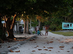
. The main settlement on the atoll is located on Atafu Island at the northwestern corner of the atoll. The Presbyterian church was established on the island in 1858, but today almost all of the residents belong to the Congregational Christian Church. The first village on Atafu was established at the southern end of the islet, and residents built houses along the lagoon shore to receive the cooling trade wind
Trade wind
The trade winds are the prevailing pattern of easterly surface winds found in the tropics, within the lower portion of the Earth's atmosphere, in the lower section of the troposphere near the Earth's equator...
s.
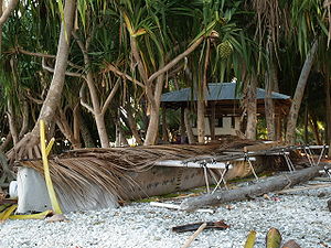
The men on Atafu are highly skilled at fishing, and they use many traditional methods that are passed on from fathers to sons. They make highly effective lures, fish traps, nets, and seines, and noose fishing is still common. They also make well-crafted canoes, which are important vehicles for their fishing expeditions.
Geography
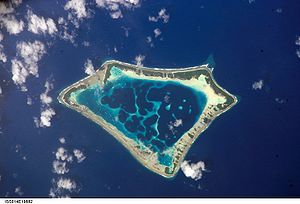
The atoll is roughly triangular in shape and encloses a lagoon some five kilometres north to south by four kilometres east to west at its widest point. It is low-lying, reaching a maximum altitude of only some five metres, and is heavily vegetated with coconut
Coconut
The coconut palm, Cocos nucifera, is a member of the family Arecaceae . It is the only accepted species in the genus Cocos. The term coconut can refer to the entire coconut palm, the seed, or the fruit, which is not a botanical nut. The spelling cocoanut is an old-fashioned form of the word...
palms and other trees, with undergrowth similar to that found on many small central Pacific islands. Lizards, rats, and seabirds are common on Atafu island. The atoll attracts a wide variety of fish in large numbers.
The eastern side of the lagoon is a nearly continuous thin strip of land with one small break halfway along its length. In contrast, the western side is composed of reef and several distinct islands, notably the inverted V shape of Atafu Island in the north, Alofi, which extends into the lagoon from the western reef, and the L-shaped Fenualoa in the southwest. The smaller Tamaseko Island lies in the lagoon close to Alofi.
The reef which connects the islands of the atoll is shallow enough that it is possible to walk between the islands at low tide. This also means that there is no boat passage to the lagoon, although the ocean becomes deep very close to the reef. This allows for good anchorage, but also makes for rough seas close to the reef. The flatness of the atoll and its location within the tropical cyclone
Cyclone
In meteorology, a cyclone is an area of closed, circular fluid motion rotating in the same direction as the Earth. This is usually characterized by inward spiraling winds that rotate anticlockwise in the Northern Hemisphere and clockwise in the Southern Hemisphere of the Earth. Most large-scale...
belt has led to damage to island properties on occasion.
History
Polynesians
The Polynesian peoples is a grouping of various ethnic groups that speak Polynesian languages, a branch of the Oceanic languages within the Austronesian languages, and inhabit Polynesia. They number approximately 1,500,000 people...
visited the island in ancient times, but they may not have settled there. The European discovery of the atoll came on June 21, 1765, by John Byron
John Byron
Vice Admiral The Hon. John Byron, RN was a Royal Navy officer. He was known as Foul-weather Jack because of his frequent bad luck with weather.-Early career:...
, of the HMS Dolphin
HMS Dolphin (1751)
HMS Dolphin was a 24-gun sixth-rate frigate of the Royal Navy. Launched in 1751, she was used as a survey ship from 1764 and made two circumnavigations of the world under the successive commands of John Byron and Samuel Wallis. She was the first ship to circumnavigate the world twice...
. Byron found no-one living on the island at that time. Atafu was established by Tonuia and his wife Lagimaina, along with their seven children.
Between 1856 and 1979, the United States claimed that it held sovereignty over the island and the other Tokelauan atolls. In 1979, the U.S. conceded that Tokelau was under New Zealand sovereignty, and a maritime boundary
Maritime boundary
Maritime boundary is a conceptual means of division of the water surface of the planet into maritime areas that are defined through surrounding physical geography or by human geography. As such it usually includes areas of exclusive national rights over the mineral and biological resources,...
between Tokelau and American Samoa
American Samoa
American Samoa is an unincorporated territory of the United States located in the South Pacific Ocean, southeast of the sovereign state of Samoa...
was established by the Treaty of Tokehega
Treaty of Tokehega
The Treaty of Tokehega is a 1980 treaty between New Zealand and the United States that delineates the maritime boundary between Tokelau and American Samoa....
.
On August 26, 2007, the attempt by Ralph Tuijn to row from South America to Australia crashlanded on Atafu. On November 26, 2010, three teenage boys from Atafu were rescued after drifting 1,300 kilometers {800 miles} for 50 days in the Pacific.