
Nukunonu
Encyclopedia
Tokelau
Tokelau is a territory of New Zealand in the South Pacific Ocean that consists of three tropical coral atolls with a combined land area of 10 km2 and a population of approximately 1,400...
in the south Pacific Ocean
Pacific Ocean
The Pacific Ocean is the largest of the Earth's oceanic divisions. It extends from the Arctic in the north to the Southern Ocean in the south, bounded by Asia and Australia in the west, and the Americas in the east.At 165.2 million square kilometres in area, this largest division of the World...
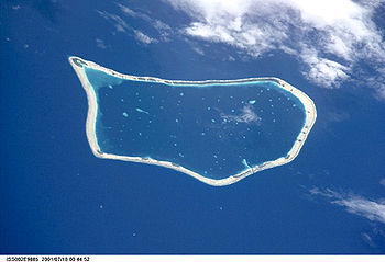
. Covering 5.5 km², it is the largest of the three islands that constitute Tokelau, and is composed of an atoll
Atoll
An atoll is a coral island that encircles a lagoon partially or completely.- Usage :The word atoll comes from the Dhivehi word atholhu OED...
surrounding a central lagoon
Lagoon
A lagoon is a body of shallow sea water or brackish water separated from the sea by some form of barrier. The EU's habitat directive defines lagoons as "expanses of shallow coastal salt water, of varying salinity or water volume, wholly or partially separated from the sea by sand banks or shingle,...
, which itself covers some 90 km². According to the 2006 census 426 people live on Nukunonu, of which more than 95% belong to the Catholic Church.
Overview
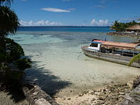
Atoll
An atoll is a coral island that encircles a lagoon partially or completely.- Usage :The word atoll comes from the Dhivehi word atholhu OED...
is located on Nukunonu Island at the southwestern edge of the lagoon with a concrete bridge joining the two areas of settlement. Other islets in the group include Motuhaga
Motuhaga
Motuhaga is an islet of the Nukunonu island group of Tokelau....
, Te Puka e Mua
Te Puka e Mua
Te Puka e Mua is an islet of the Nukunonu island group of Tokelau....
, Ahua
Ahua
Ahua is an islet of the Nukunonu island group of Tokelau....
, Motufala
Motufala
Motufala is an islet of the Nukunonu island group of Tokelau....
, Punalei
Punalei
Punalei is an islet of the Nukunonu island group of Tokelau....
, Taulagapapa
Taulagapapa
Taulagapapa is an islet of the Nukunonu island group of Tokelau....
, Niututahi
Niututahi
Niututahi is an islet of the Nukunonu island group of Tokelau....
, Saumagalu
Saumagalu
Saumagalu is an islet of the Nukunonu island group of Tokelau....
, Apia
Apia, Tokelau
Apia, Tokelau is an islet of the Nukunonu island group of Tokelau....
, Laulauia
Laulauia
Laulauia is an islet of the Nukunonu island group of Tokelau....
, Avakilikili
Avakilikili
Avakilikili is an islet of the Nukunonu island group of Tokelau....
, Fatigauhu
Fatigauhu
Fatigauhu is an islet of the Nukunonu island group of Tokelau....
, Tokelau
Tokelau (islet)
Tokelau is an islet of the Nukunonu island group of Tokelau....
, Te Fakanava
Te Fakanava
Te Fakanava is an islet of the Nukunonu island group of Tokelau....
, Te Puku
Te Puku
Te Puku is an islet of the Nukunonu island group of Tokelau....
, and Te Kamu
Te Kamu
Te Kamu is an islet of the Nukunonu island group of Tokelau....
to name a few. The atoll is located at 171° 50' West, 9° 10' South.
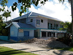
Tokelau has one hotel, the Luana Liki Hotel
Luana Liki Hotel
Luana Liki Hotel is a hotel in Nukunonu, Tokelau. It is the only hotel in Tokelau. Numerous distinguished guests have stayed at the hotel including New Zealand Premier Helen Clarke and the New Zealand Governor General....
, and one resort, Falefa Resort, both situated on Nukunonu. Few tourists visit the country and tourism is not widely promoted. There is ambivalence to the idea of tourists with some Tokelauans wanting to keep the country unaffected by the outside world. Despite this, visitors are greeted with traditional Polynesian hospitality. The Luana Liki Hotel functions mainly to accommodate official visitors who have included the New Zealand Prime Minister and Governor General. There is one main shop in Nukunonu which sells a limited range of products. Due to the vagaries of shipping schedules it is at times short of goods.
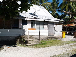
Concrete water tanks are incorporated into the base of newly built houses and collect rain water from the roof. Satellite TV dishes are beginning to appear on some houses in the village.
Between 1856 and 1979, the United States claimed that it held sovereignty over the island and the other Tokelauan atolls. In 1979, the U.S. conceded that Tokelau was under New Zealand sovereignty, and a maritime boundary
Maritime boundary
Maritime boundary is a conceptual means of division of the water surface of the planet into maritime areas that are defined through surrounding physical geography or by human geography. As such it usually includes areas of exclusive national rights over the mineral and biological resources,...
between Tokelau and American Samoa
American Samoa
American Samoa is an unincorporated territory of the United States located in the South Pacific Ocean, southeast of the sovereign state of Samoa...
was established by the Treaty of Tokehega
Treaty of Tokehega
The Treaty of Tokehega is a 1980 treaty between New Zealand and the United States that delineates the maritime boundary between Tokelau and American Samoa....
.

