
Cyclone Olaf
Encyclopedia
Cyclone Olaf was the sixth cyclone to form in the Southwest Pacific Ocean during the 2004-05 South Pacific cyclone season
. Olaf was also one of three simultaneous cyclones to form during the 2004-05 season, forming 21 hours after Cyclone Nancy formed to the east. A powerful Category 5 cyclone, Olaf stuck American Samoa
causing heavy damage although exact estimates are unknown. Despite the damage, there were no reported deaths or injuries from the cyclone. Olaf was third South Pacific cyclone to hit the Cook Islands
during the 2004-05 season (the other two being Meena and Nancy), and Cyclone Percy
would later affect the already devastated archapelago less than 2 weeks later.
formed on February 10. The tropical wave, then spawned two areas of low pressure, one of which became Tropical Depression 08F. At 1300 UTC, the tropical depression was located 490 miles north west of Apia. By 1500, the depression organized into a tropical storm with 40 mph wind and was named Olaf. At the time of formation, the tropical storm was nearly stationary. The low wind shear
and warm water temperatures allowed Olaf to undergo rapid intensification. In a 12 hour period, Olaf quickly became a Category 1 cyclone with 80 mph (130 km/h) winds in a 10 minute average speed. On February 15, the barometric pressure fell to 930 mbar as Olaf reached Category 4 status. After reaching Category 4 status, Olaf then moved on a south-southeasterly course at 7 mph (11 km/h).
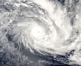
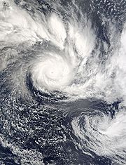
Cyclone Olaf then tuned east and moving 100 miles (165 km) east of Western Samoa. On February 16, satellite imagery depicted a well-defined eye as Olaf strengthened into a Category 5 cyclone. Olaf reached a peak intensity of 165 mph with a barometric pressure of 915 millibars. It is possible Olaf could have a lower pressure but official track reports have Olaf at 915 mbar. At the time of peak intensity, the center of the storm was only 70 miles (120 km) northeast of American Samoa
and 90 miles (145 km) northwest of Pago Pago. At the same time, Cyclone Olaf underwent a minor Fujiwhara effect
with Cyclone Nancy before resuming its southeasterly course. Moving at 10 mph (16 km/h), the cyclone maintained Category 5 status as the eye passed 15 miles east of Ta'u, American Samoa
. During that time, a weather station reported a 931 barometric pressure reading.
On February 18, an approaching upper level trough to the south, and strong wind shear
caused Olaf to weaken as the storm rapidly moved southeastward. As Olaf moved into the New Zealand
area of responsibility, the main circulation separated from the center and Olaf quickly became extratropical 18 hours later. The extratropical remnants of Olaf, quickly re-intensified into a powerful extratropical storm on February 23. The extratropical storm persisted for two days before dissipating near Pitcairn Island
as a Category 4 cyclone. In American Samoa, schools and businesses were closed and warnings were broadcasting over television and radio. Forecasters predicted that Olaf will bring storm surge
and inland flooding and strong winds. In Niue
, the cyclone was carefully monitored by forecasters, fearing a repeat of the destruction wrought by Cyclone Heta a year ago. French Polynesia
was also under a cyclone warning. Forecasters further issued Watches and warnings for the rest of the Cook Islands
.
The next day, Olaf diverted course forcing authorities to order evacuations. In Tutuila
, 70 emergency shelters were opened and 1,000 people evacuated low lying areas. The approach of the cyclone, shut down the local airport, cancelling numerous flights. In Tau
, most of the residences evacuated to storm shelters built on higher ground. The evaluation in the Manu'a group islands, totaled up to 2,000.
, Olaf caused severe damage in both Samoa and American Samoa. Because of well executed warnings and evacuations, there were no deaths. However, 2 people were reported missing and assumed dead, when their boat sank during the storm.
 Although the eye of Olaf never made landfall, several weather stations reported sustained winds of 75-125 mph (120–200 km/h). The winds damaged powerlines and closed an airport. Olaf also produced storm surge
damage along the coast. Offshore, fishing fleet was caught off guard by the storm. One of the boats, sank 150 miles (240 km) off the coast of Samoa, however the crew was rescued. 21 other fishermen were also rescued. Olaf then brushed past the American Samoa, bringing 125 mph (200 km/h) winds. Because of Olaf strength, there was severe damage across American Samoa. In the Manua Islands, the storm destroyed several seaside homes, ruined crops and left thousands without power. In Tau
, 80-90 percent of the infrastructure was destroyed by the storm. Offshore, three people were rescued after their boat sank near Pago Pago.
which were already reeling form the impact of Cyclones Meena and Nancy earlier. In Rarotonga
, Olaf skirted the western side of the island. That placed the island in the strongest part of the storm, which resulted in extensive damage to homes and businesses. According to press reports, nearly 30-40 percent of the population was left without electricity and 60% of the structures sustained damage.
declared those islands disaster areas. The declaration allowed residents and local governments in the American Samoa to receive federal aid. The Federal Emergency Management Agency
provided much aid to the residents of the American Samoa. The Initial Response Resources were sent to the American Samoa and its surrounding islands and was distributed by the United States Coast Guard
and the government of the American Samoa on February 21, 2005. Despite the devastation in the Manua Islands, it could have been worse if Olaf hit American Samoa directly. In the Cook Islands, the Australian and New Zealand
governments provided over A$30,000 (2005) in relief assistance. On February 22, 2005, the Government of New Zealand, provided materials and workmen to help with the clean up effort. The French government and the United Nations
also assisted in the relief effort by sending soldiers from Tahiti
and providing more aid to the striken residents.
2004-05 South Pacific cyclone season
Late on October 28, RSMC Nadi reported that a tropical depression had formed about 420 km, to the northeast of Honiara in the Solomon Islands. The depressions low level circulation center at this time was located under the deep convection and lied in a weak monsoonal trough which had a low to...
. Olaf was also one of three simultaneous cyclones to form during the 2004-05 season, forming 21 hours after Cyclone Nancy formed to the east. A powerful Category 5 cyclone, Olaf stuck American Samoa
American Samoa
American Samoa is an unincorporated territory of the United States located in the South Pacific Ocean, southeast of the sovereign state of Samoa...
causing heavy damage although exact estimates are unknown. Despite the damage, there were no reported deaths or injuries from the cyclone. Olaf was third South Pacific cyclone to hit the Cook Islands
Cook Islands
The Cook Islands is a self-governing parliamentary democracy in the South Pacific Ocean in free association with New Zealand...
during the 2004-05 season (the other two being Meena and Nancy), and Cyclone Percy
Cyclone Percy
Cyclone Percy was the seventh named storm of the 2004-05 South Pacific cyclone season and the fourth and final cyclone to form during the February 2005 outbreak in the South Pacific Ocean....
would later affect the already devastated archapelago less than 2 weeks later.
Meteorological history
A tropical waveTropical wave
Tropical waves, easterly waves, or tropical easterly waves, also known as African easterly waves in the Atlantic region, are a type of atmospheric trough, an elongated area of relatively low air pressure, oriented north to south, which move from east to west across the tropics causing areas of...
formed on February 10. The tropical wave, then spawned two areas of low pressure, one of which became Tropical Depression 08F. At 1300 UTC, the tropical depression was located 490 miles north west of Apia. By 1500, the depression organized into a tropical storm with 40 mph wind and was named Olaf. At the time of formation, the tropical storm was nearly stationary. The low wind shear
Wind shear
Wind shear, sometimes referred to as windshear or wind gradient, is a difference in wind speed and direction over a relatively short distance in the atmosphere...
and warm water temperatures allowed Olaf to undergo rapid intensification. In a 12 hour period, Olaf quickly became a Category 1 cyclone with 80 mph (130 km/h) winds in a 10 minute average speed. On February 15, the barometric pressure fell to 930 mbar as Olaf reached Category 4 status. After reaching Category 4 status, Olaf then moved on a south-southeasterly course at 7 mph (11 km/h).
Cyclone Olaf then tuned east and moving 100 miles (165 km) east of Western Samoa. On February 16, satellite imagery depicted a well-defined eye as Olaf strengthened into a Category 5 cyclone. Olaf reached a peak intensity of 165 mph with a barometric pressure of 915 millibars. It is possible Olaf could have a lower pressure but official track reports have Olaf at 915 mbar. At the time of peak intensity, the center of the storm was only 70 miles (120 km) northeast of American Samoa
American Samoa
American Samoa is an unincorporated territory of the United States located in the South Pacific Ocean, southeast of the sovereign state of Samoa...
and 90 miles (145 km) northwest of Pago Pago. At the same time, Cyclone Olaf underwent a minor Fujiwhara effect
Fujiwhara effect
The Fujiwhara effect or Fujiwara interaction, named after Sakuhei Fujiwhara, is a type of interaction between two nearby cyclonic vortices, causing them to appear to "orbit" each other.-Description:...
with Cyclone Nancy before resuming its southeasterly course. Moving at 10 mph (16 km/h), the cyclone maintained Category 5 status as the eye passed 15 miles east of Ta'u, American Samoa
American Samoa
American Samoa is an unincorporated territory of the United States located in the South Pacific Ocean, southeast of the sovereign state of Samoa...
. During that time, a weather station reported a 931 barometric pressure reading.
On February 18, an approaching upper level trough to the south, and strong wind shear
Wind shear
Wind shear, sometimes referred to as windshear or wind gradient, is a difference in wind speed and direction over a relatively short distance in the atmosphere...
caused Olaf to weaken as the storm rapidly moved southeastward. As Olaf moved into the New Zealand
New Zealand
New Zealand is an island country in the south-western Pacific Ocean comprising two main landmasses and numerous smaller islands. The country is situated some east of Australia across the Tasman Sea, and roughly south of the Pacific island nations of New Caledonia, Fiji, and Tonga...
area of responsibility, the main circulation separated from the center and Olaf quickly became extratropical 18 hours later. The extratropical remnants of Olaf, quickly re-intensified into a powerful extratropical storm on February 23. The extratropical storm persisted for two days before dissipating near Pitcairn Island
Preparations
Forecasts predicted Olaf to move near and over Samoa and American Samoa in 24–48 hours and hitting the southern Cook IslandsCook Islands
The Cook Islands is a self-governing parliamentary democracy in the South Pacific Ocean in free association with New Zealand...
as a Category 4 cyclone. In American Samoa, schools and businesses were closed and warnings were broadcasting over television and radio. Forecasters predicted that Olaf will bring storm surge
Storm surge
A storm surge is an offshore rise of water associated with a low pressure weather system, typically tropical cyclones and strong extratropical cyclones. Storm surges are caused primarily by high winds pushing on the ocean's surface. The wind causes the water to pile up higher than the ordinary sea...
and inland flooding and strong winds. In Niue
Niue
Niue , is an island country in the South Pacific Ocean. It is commonly known as the "Rock of Polynesia", and inhabitants of the island call it "the Rock" for short. Niue is northeast of New Zealand in a triangle between Tonga to the southwest, the Samoas to the northwest, and the Cook Islands to...
, the cyclone was carefully monitored by forecasters, fearing a repeat of the destruction wrought by Cyclone Heta a year ago. French Polynesia
French Polynesia
French Polynesia is an overseas country of the French Republic . It is made up of several groups of Polynesian islands, the most famous island being Tahiti in the Society Islands group, which is also the most populous island and the seat of the capital of the territory...
was also under a cyclone warning. Forecasters further issued Watches and warnings for the rest of the Cook Islands
Cook Islands
The Cook Islands is a self-governing parliamentary democracy in the South Pacific Ocean in free association with New Zealand...
.
The next day, Olaf diverted course forcing authorities to order evacuations. In Tutuila
Tutuila
Tutuila is the largest and the main island of American Samoa in the archipelago of Samoan Islands. It is the third largest island in the Samoan Islands chain of the Central Pacific located roughly northeast of Brisbane, Australia and over northeast of Fiji. It contains a large, natural harbor,...
, 70 emergency shelters were opened and 1,000 people evacuated low lying areas. The approach of the cyclone, shut down the local airport, cancelling numerous flights. In Tau
Tau
Tau is the 19th letter of the Greek alphabet. In the system of Greek numerals it has a value of 300.The name in English is pronounced , but in modern Greek it is...
, most of the residences evacuated to storm shelters built on higher ground. The evaluation in the Manu'a group islands, totaled up to 2,000.
Impact
A destructive cycloneCyclone
In meteorology, a cyclone is an area of closed, circular fluid motion rotating in the same direction as the Earth. This is usually characterized by inward spiraling winds that rotate anticlockwise in the Northern Hemisphere and clockwise in the Southern Hemisphere of the Earth. Most large-scale...
, Olaf caused severe damage in both Samoa and American Samoa. Because of well executed warnings and evacuations, there were no deaths. However, 2 people were reported missing and assumed dead, when their boat sank during the storm.
Samoa and American Samoa
Storm surge
A storm surge is an offshore rise of water associated with a low pressure weather system, typically tropical cyclones and strong extratropical cyclones. Storm surges are caused primarily by high winds pushing on the ocean's surface. The wind causes the water to pile up higher than the ordinary sea...
damage along the coast. Offshore, fishing fleet was caught off guard by the storm. One of the boats, sank 150 miles (240 km) off the coast of Samoa, however the crew was rescued. 21 other fishermen were also rescued. Olaf then brushed past the American Samoa, bringing 125 mph (200 km/h) winds. Because of Olaf strength, there was severe damage across American Samoa. In the Manua Islands, the storm destroyed several seaside homes, ruined crops and left thousands without power. In Tau
Tau
Tau is the 19th letter of the Greek alphabet. In the system of Greek numerals it has a value of 300.The name in English is pronounced , but in modern Greek it is...
, 80-90 percent of the infrastructure was destroyed by the storm. Offshore, three people were rescued after their boat sank near Pago Pago.
Cook Islands
Olaf then struck the Cook IslandsCook Islands
The Cook Islands is a self-governing parliamentary democracy in the South Pacific Ocean in free association with New Zealand...
which were already reeling form the impact of Cyclones Meena and Nancy earlier. In Rarotonga
Rarotonga
Rarotonga is the most populous island of the Cook Islands, with a population of 14,153 , out of the country's total population of 19,569.The Cook Islands' Parliament buildings and international airport are on Rarotonga...
, Olaf skirted the western side of the island. That placed the island in the strongest part of the storm, which resulted in extensive damage to homes and businesses. According to press reports, nearly 30-40 percent of the population was left without electricity and 60% of the structures sustained damage.
Aftermath
Olaf damaged several water stations in the Manua Islands causing a water shortage. Because of the damage, President George W. BushGeorge W. Bush
George Walker Bush is an American politician who served as the 43rd President of the United States, from 2001 to 2009. Before that, he was the 46th Governor of Texas, having served from 1995 to 2000....
declared those islands disaster areas. The declaration allowed residents and local governments in the American Samoa to receive federal aid. The Federal Emergency Management Agency
Federal Emergency Management Agency
The Federal Emergency Management Agency is an agency of the United States Department of Homeland Security, initially created by Presidential Reorganization Plan No. 1 of 1978 and implemented by two Executive Orders...
provided much aid to the residents of the American Samoa. The Initial Response Resources were sent to the American Samoa and its surrounding islands and was distributed by the United States Coast Guard
United States Coast Guard
The United States Coast Guard is a branch of the United States Armed Forces and one of the seven U.S. uniformed services. The Coast Guard is a maritime, military, multi-mission service unique among the military branches for having a maritime law enforcement mission and a federal regulatory agency...
and the government of the American Samoa on February 21, 2005. Despite the devastation in the Manua Islands, it could have been worse if Olaf hit American Samoa directly. In the Cook Islands, the Australian and New Zealand
New Zealand
New Zealand is an island country in the south-western Pacific Ocean comprising two main landmasses and numerous smaller islands. The country is situated some east of Australia across the Tasman Sea, and roughly south of the Pacific island nations of New Caledonia, Fiji, and Tonga...
governments provided over A$30,000 (2005) in relief assistance. On February 22, 2005, the Government of New Zealand, provided materials and workmen to help with the clean up effort. The French government and the United Nations
United Nations
The United Nations is an international organization whose stated aims are facilitating cooperation in international law, international security, economic development, social progress, human rights, and achievement of world peace...
also assisted in the relief effort by sending soldiers from Tahiti
Tahiti
Tahiti is the largest island in the Windward group of French Polynesia, located in the archipelago of the Society Islands in the southern Pacific Ocean. It is the economic, cultural and political centre of French Polynesia. The island was formed from volcanic activity and is high and mountainous...
and providing more aid to the striken residents.