
2004-05 South Pacific cyclone season
Encyclopedia
Late on October 28, RSMC Nadi reported that a tropical depression had formed about 420 km, (260 mi) to the northeast of Honiara
in the Solomon Islands
. The depressions low level circulation center at this time was located under the deep convection and lied in a weak monsoonal trough which had a low to moderate amount of wind shear. Over the next couple of days the system moved towards the west until late on October 30, when RSMC Nadi released their final advisory on the depression as it was now located within TCWC Brisbane’s area of responsibility. TCWC Brisbane mentioned the depression in their tropical weather outlooks for a couple of days but never released any full warnings on the system. There was no impact reported from Tropical Depression 01F.
. The depression was located within an area of moderate shear, as a consequence of this major convection was displaced to the east of the low level circulation center. Over the next few days the depression moved towards the east and gradually weakened. However late on December 9 RSMC Nadi reported that the depression had re-intensified and had reached its peak wind speeds of 55 km/h (35 mph). Early the next day RSMC Nadi reported that a new circulation center had developed and relocated the depression's position to about 600 km (372.8 mi) to the northeast of Fiji. However later that day RSMC Nadi relocated the disturbance to about 600 km (372.8 mi) to the northwest of Fiji. During December 12 as the depression moved to the south and was located a few hundred miles to the east of northern Vanuatu, the depression's low level circulation center consolidated and thus Nadi started to issue gale warnings on the depression however the depression then weakened and Nadi issued their final warning on December 14. There was no impact reported from Tropical Depression 02F.
, Vanuatu
. Kerry moved to the southwest with 40 knots (78.4 km/h) winds as it moved over Vanuatu. Once past the island, Kerry moved on a west-southwest course and it began to intensify after turning to the west. The storm reached a peak intensity of 85 knots (167 km/h) before turning towards the south-southeast. The storm began to weaken under vertical shear and was downgraded to a depression on January 13.
. Lola reached a peak intensity of 40 knots (78.4 km/h), but was downgraded to a depression on February 2.
developed.
, developing over the center of circulation
, whilst it was located about 485 km (301.4 mi) east-northeast of Pago Pago, American Samoa
. During that day Nancy started to rapidly intensify becoming a Severe Tropical Cyclone late on February 13 as a small, irregularly shaped, eye
had begun to develop.
The next day both RSMC Nadi, and the JTWC reported that Cyclone Nancy had attained its peak intensity of 175 km/h (110 mph 10-minute winds) and 230 km/h (145 mph 1-minute winds). Increasing wind shear then caused Nancy to weaken. Early on February 15, the storm passed directly over Manuae
. Continued weakening took place as a trough of low pressure approached from the southwest. By February 16, Nancy weakened below hurricane intensity and turned to the southwest as it began to undergo a Fujiwhara interaction with Cyclone Olaf, strong shear associated with the outflow of Cyclone Olaf caused all convection associated with Nancy to be displaced to the southwest on February 16. Early on February 17, Nancy transitioned into an extratropical cyclone
as it entered the area of responsibility of TCWC Wellington. Shortly afterwards, the low was absorbed into the larger circulation of Olaf however it was monitored by TCWC Wellington as a separate system until 1200 UTC on February 18.
Already impacted by Cyclone Meena a week earlier, the Cook Islands sustained significant damage from Cyclone Nancy. Several homes were damaged and destroyed throughout the islands. Downed trees and power lines blocked roads and cut power and minor flooding was reported along coastal areas.
status north of American Samoa
. The cyclone then moved eastward, peaking at Category 5
status before turning southward. Percy then passed through the southwestern Cook Islands
causing severe damage before dissipating.
. The depression was located east of an 250hPa outflow channel and was poorly organised with major convection located to the northeast of the low level circulation center. During the next morning RSMC Nadi downgraded the depression to a tropical disturbance as they issued their final advisory on the depression.
. Over the next couple of days the system gradually developed and before it was declared as a tropical disturbance early on March 1. At this time convection detached from the disturbance's low level circulation center, whilst vertical wind shear around the system remained weak. Early the next day, the Disturbance was then relocated to the northwest of Viti Levu
in Fiji, before it was designated as Tropical Depression 13F later that day. The Depression remained weak reaching an estimated central pressure of 1001 hPa (mbar) early on March 3, however there were no winds reported by RSMC Nadi whilst they were monitoring it. RSMC Nadi then issued their last advisory on 13F early on March 4 after no persistent convection reported around the system since the depression reached its peak pressure.
during the 2004–2005 season. It includes their intensity on the Australian Tropical cyclone intensity scale, duration, name, landfalls, deaths, and damages. All data is taken from RSMC Nadi and or TCWC Wellington. The Damage figures are all 2005 USD.
Honiara
Honiara, population 49,107 , 78,190 , is the capital of the Solomon Islands and of Guadalcanal Province, although it is a separately administered town...
in the Solomon Islands
Solomon Islands
Solomon Islands is a sovereign state in Oceania, east of Papua New Guinea, consisting of nearly one thousand islands. It covers a land mass of . The capital, Honiara, is located on the island of Guadalcanal...
. The depressions low level circulation center at this time was located under the deep convection and lied in a weak monsoonal trough which had a low to moderate amount of wind shear. Over the next couple of days the system moved towards the west until late on October 30, when RSMC Nadi released their final advisory on the depression as it was now located within TCWC Brisbane’s area of responsibility. TCWC Brisbane mentioned the depression in their tropical weather outlooks for a couple of days but never released any full warnings on the system. There was no impact reported from Tropical Depression 01F.
Tropical Depression 02F
Late on December 3, RSMC Nadi reported that Tropical Depression 02F had formed about 280 km (174 mi) to the north of Port Villa in VanuatuVanuatu
Vanuatu , officially the Republic of Vanuatu , is an island nation located in the South Pacific Ocean. The archipelago, which is of volcanic origin, is some east of northern Australia, northeast of New Caledonia, west of Fiji, and southeast of the Solomon Islands, near New Guinea.Vanuatu was...
. The depression was located within an area of moderate shear, as a consequence of this major convection was displaced to the east of the low level circulation center. Over the next few days the depression moved towards the east and gradually weakened. However late on December 9 RSMC Nadi reported that the depression had re-intensified and had reached its peak wind speeds of 55 km/h (35 mph). Early the next day RSMC Nadi reported that a new circulation center had developed and relocated the depression's position to about 600 km (372.8 mi) to the northeast of Fiji. However later that day RSMC Nadi relocated the disturbance to about 600 km (372.8 mi) to the northwest of Fiji. During December 12 as the depression moved to the south and was located a few hundred miles to the east of northern Vanuatu, the depression's low level circulation center consolidated and thus Nadi started to issue gale warnings on the depression however the depression then weakened and Nadi issued their final warning on December 14. There was no impact reported from Tropical Depression 02F.
Tropical Depression 03F
Early on December 5, a weak tropical disturbance formed within a moderately sheared environment to the northwest of Fiji. Later that day it was designated as Tropical Depression 03F by RSMC Nadi. Deep convection was detached from the Low level circulation center and remained to the north and south of the depression. Over the next couple of days the depression remained weak reaching a peak pressure of 1003 hPa, before being absorbed into a trough of low pressure on December 8. RSMC Nadi then issued its final advisory on December 10 as the depression had dissipated after remaining weak throughout its lifetime.Tropical Cyclone Judy
On December 21, RSMC Nadi reported that Tropical Disturbance 04F had developed, along an active and slow-moving monsoon trough near French Polynesia. The depression was in an area of high shear, with the deep convection located to the northeast of the center. The low level circulation center at this time was exposed but was developing despite the high shear associated with the system. Early on December 24 deep convection associated with the system moved over the low level circulation center whilst the system was getting better organized. Later that day at 1800 UTC the Depression was upgraded to a category one tropical cyclone and was named Judy whilst located about 510 km (316.9 mi) southeast of Tahiti and moving towards the southwest. During the next few hours under strengthening shear, Judy struggled to maintain itself. However as it moved further to the south if came under a strengthening steering field which was being enhanced by a trough of low pressure to the west of the steering field which helped to neutralize the effect of the shear over the cyclone. Judy then intensified slightly further and reached its peak intensity of 85 km/h, (50 mph), with a peak pressure of 989 hPa late on December 25 whilst turning towards the south towards TCWC Wellington's area of responsibility. RSMC Nadi then released their final advisory on Cyclone Judy early the next day as they passed primary warning responsibility of the cyclone to TCWC Wellington. The cyclone had started to weaken by this time due to it moving in to cooler waters. TCWC Wellington kept Judy as a tropical cyclone for 12 hours before declaring it had become extratropical. The remnants of Judy eventually merged with a low pressure system to the southeast of Tahiti.Severe Tropical Cyclone Kerry
Tropical Cyclone Kerry developed from Tropical Depression 05F on January 5, 315 nautical miles (583 km) northeast of Port VilaPort Vila
Port Vila is the capital and largest city of Vanuatu. Situated on the south coast of the island of Efate, in Shefa Province, the city population at last was 29,356, an increase of 55% on the previous census result . This suggests a 2007 population of about 40,000 or around 65% of the province's...
, Vanuatu
Vanuatu
Vanuatu , officially the Republic of Vanuatu , is an island nation located in the South Pacific Ocean. The archipelago, which is of volcanic origin, is some east of northern Australia, northeast of New Caledonia, west of Fiji, and southeast of the Solomon Islands, near New Guinea.Vanuatu was...
. Kerry moved to the southwest with 40 knots (78.4 km/h) winds as it moved over Vanuatu. Once past the island, Kerry moved on a west-southwest course and it began to intensify after turning to the west. The storm reached a peak intensity of 85 knots (167 km/h) before turning towards the south-southeast. The storm began to weaken under vertical shear and was downgraded to a depression on January 13.
Tropical Cyclone Lola
Tropical Storm Lola developed from Tropical Depression 06F on January 31, 100 nautical miles (185.2 km) west-southwest of TongatapuTongatapu
Tongatapu is the main island of the Kingdom of Tonga and the location of its capital Nukualofa. It is located in Tonga's southern island group, to which it gives its name, and is the country's most populous island, with approximately 71,260 residents , 70.5% of the national population...
. Lola reached a peak intensity of 40 knots (78.4 km/h), but was downgraded to a depression on February 2.
Severe Tropical Cyclone Meena
On February 1, the RSMC Nadi began monitoring a tropical disturbance, which they designated as 07F, to the west of the northern Cook Islands. The next day, a small area of deep convectionAtmospheric convection
Atmospheric convection is the result of a parcel-environment instability, or temperature difference, layer in the atmosphere. Different lapse rates within dry and moist air lead to instability. Mixing of air during the day which expands the height of the planetary boundary layer leads to...
developed.
Severe Tropical Cyclone Olaf
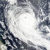
The most intense system of the season, Tropical Cyclone Olaf developed rapidly like Nancy. By February 16, Olaf had attained maximum sustained winds of 145 knots (284 km/h) and was thrashing American Samoa. However bad the damage was, it could have been worse as Olaf veered east, its eyewall missing the islands.Severe Tropical Cyclone Nancy
Cyclone Nancy formed on February 10 as Tropical Disturbance 09F, over the next couple of days. The disturbance gradually developed and was designated as Cyclone Nancy during February 12 due to its outflow improving and a small area of deep convectionAtmospheric convection
Atmospheric convection is the result of a parcel-environment instability, or temperature difference, layer in the atmosphere. Different lapse rates within dry and moist air lead to instability. Mixing of air during the day which expands the height of the planetary boundary layer leads to...
, developing over the center of circulation
Eye (cyclone)
The eye is a region of mostly calm weather found at the center of strong tropical cyclones. The eye of a storm is a roughly circular area and typically 30–65 km in diameter. It is surrounded by the eyewall, a ring of towering thunderstorms where the second most severe weather of a cyclone...
, whilst it was located about 485 km (301.4 mi) east-northeast of Pago Pago, American Samoa
Pago Pago, American Samoa
Pago Pago , also spelled ', is the capital of American Samoa. In 2000, its population was 11,500. The city is served by Pago Pago International Airport. Tourism, entertainment, food, and tuna canning are the primary industries here. From 1878 to 1951, this was a coaling and repair station for the...
. During that day Nancy started to rapidly intensify becoming a Severe Tropical Cyclone late on February 13 as a small, irregularly shaped, eye
Eye (cyclone)
The eye is a region of mostly calm weather found at the center of strong tropical cyclones. The eye of a storm is a roughly circular area and typically 30–65 km in diameter. It is surrounded by the eyewall, a ring of towering thunderstorms where the second most severe weather of a cyclone...
had begun to develop.
The next day both RSMC Nadi, and the JTWC reported that Cyclone Nancy had attained its peak intensity of 175 km/h (110 mph 10-minute winds) and 230 km/h (145 mph 1-minute winds). Increasing wind shear then caused Nancy to weaken. Early on February 15, the storm passed directly over Manuae
Manuae
Manuae is an uninhabited atoll in the southern group of the Cook Islands, 100 kilometres south-east of Aitutaki. It is administratively part of Aitutaki, but does not belong to any district or tapere of Aitutaki. It is, however, part of Arutanga-Reureu-Nikaupara Constituency.Manuae is a true atoll...
. Continued weakening took place as a trough of low pressure approached from the southwest. By February 16, Nancy weakened below hurricane intensity and turned to the southwest as it began to undergo a Fujiwhara interaction with Cyclone Olaf, strong shear associated with the outflow of Cyclone Olaf caused all convection associated with Nancy to be displaced to the southwest on February 16. Early on February 17, Nancy transitioned into an extratropical cyclone
Extratropical cyclone
Extratropical cyclones, sometimes called mid-latitude cyclones or wave cyclones, are a group of cyclones defined as synoptic scale low pressure weather systems that occur in the middle latitudes of the Earth having neither tropical nor polar characteristics, and are connected with fronts and...
as it entered the area of responsibility of TCWC Wellington. Shortly afterwards, the low was absorbed into the larger circulation of Olaf however it was monitored by TCWC Wellington as a separate system until 1200 UTC on February 18.
Already impacted by Cyclone Meena a week earlier, the Cook Islands sustained significant damage from Cyclone Nancy. Several homes were damaged and destroyed throughout the islands. Downed trees and power lines blocked roads and cut power and minor flooding was reported along coastal areas.
Severe Tropical Cyclone Percy
Percy quickly formed from an area of low pressure on February 24 and reached Category 1Saffir-Simpson Hurricane Scale
The Saffir–Simpson Hurricane Scale , or the Saffir–Simpson Hurricane Wind Scale , classifies hurricanes — Western Hemisphere tropical cyclones that exceed the intensities of tropical depressions and tropical storms — into five categories distinguished by the intensities of their sustained winds...
status north of American Samoa
American Samoa
American Samoa is an unincorporated territory of the United States located in the South Pacific Ocean, southeast of the sovereign state of Samoa...
. The cyclone then moved eastward, peaking at Category 5
Saffir-Simpson Hurricane Scale
The Saffir–Simpson Hurricane Scale , or the Saffir–Simpson Hurricane Wind Scale , classifies hurricanes — Western Hemisphere tropical cyclones that exceed the intensities of tropical depressions and tropical storms — into five categories distinguished by the intensities of their sustained winds...
status before turning southward. Percy then passed through the southwestern Cook Islands
Cook Islands
The Cook Islands is a self-governing parliamentary democracy in the South Pacific Ocean in free association with New Zealand...
causing severe damage before dissipating.
Tropical Depression 11F
Late on February 26, RSMC Nadi reported that Tropical Depression 11F had formed about 1200 km (745.6 mi), to the northwest of Henderson IslandHenderson Island (Pitcairn Islands)
Henderson Island is an uninhabited raised coral atoll in the south Pacific Ocean, that in 1902 was annexed to the Pitcairn Islands colony, a South Pacific Dependent Territory of the United Kingdom. Measuring long and wide, it has an area of and is located northeast of Pitcairn Island at . The...
. The depression was located east of an 250hPa outflow channel and was poorly organised with major convection located to the northeast of the low level circulation center. During the next morning RSMC Nadi downgraded the depression to a tropical disturbance as they issued their final advisory on the depression.
Tropical Depression 13F
Late on February 27, RSMC Nadi reported that a suspect tropical disturbance was developing near to the north of Rennel Island, in the Solomon IslandsSolomon Islands
Solomon Islands is a sovereign state in Oceania, east of Papua New Guinea, consisting of nearly one thousand islands. It covers a land mass of . The capital, Honiara, is located on the island of Guadalcanal...
. Over the next couple of days the system gradually developed and before it was declared as a tropical disturbance early on March 1. At this time convection detached from the disturbance's low level circulation center, whilst vertical wind shear around the system remained weak. Early the next day, the Disturbance was then relocated to the northwest of Viti Levu
Viti Levu
Viti Levu is the largest island in the Republic of Fiji, the site of the nation's capital, Suva, and home to a large majority of Fiji's population.- Geography and economy :...
in Fiji, before it was designated as Tropical Depression 13F later that day. The Depression remained weak reaching an estimated central pressure of 1001 hPa (mbar) early on March 3, however there were no winds reported by RSMC Nadi whilst they were monitoring it. RSMC Nadi then issued their last advisory on 13F early on March 4 after no persistent convection reported around the system since the depression reached its peak pressure.
Tropical Disturbance 16F
Late on April 20, RSMC Nadi reported that Tropical Disturbance 16F had formed to the east of Fiji. Over the next couple of days the disturbance remained weak in an area of moderate vertical wind shear and poorly organised before the final advisory was issued early on April 22.Tropical Depression 17F
Early on April 26, RSMC Nadi reported that Tropical depression 17F had formed to the east of Tokelau and was located within an area of low to moderate vertical wind shear. Convection around the system was also poorly orgainsed. The depression moved slowly towards the west before early on April 29 the low level circulation center was relocated to the northeast of Vanautu with deep convection detached from the low level circulation center and located to the southeast of the center with the system not showing much improvement over the last 24 hours. Late the next day it was redesignated as a weak Tropical Depression by RSMC Nadi as there was now no organised convection in the vicinity of the low level circulation center. The final advisory was issued by RSMC Nadi late on May 1.Tropical Depression 18F
Late on April 29, RSMC Nadi reported that Tropical Depression 18F, had formed to the northwest of Wallis and Futuna. Deep Convection was located to the south of the low level circulation center and was in an area of low to mid vertical windshear. However it failed to develop any further and was redesignated as a weak tropical depression late the next day as there was not any orgainsed convection near the center. RSMC Nadi then issued their final advisory late on May 1.Season effects
This table lists all the storms that developed in the South Pacific to the east of longitude 160°E160th meridian east
The meridian 160° east of Greenwich is a line of longitude that extends from the North Pole across the Arctic Ocean, Asia, the Pacific Ocean, the Southern Ocean, and Antarctica to the South Pole....
during the 2004–2005 season. It includes their intensity on the Australian Tropical cyclone intensity scale, duration, name, landfalls, deaths, and damages. All data is taken from RSMC Nadi and or TCWC Wellington. The Damage figures are all 2005 USD.
See also
- List of Southern Hemisphere tropical cyclone seasons
- Atlantic hurricane seasons: 20042004 Atlantic hurricane seasonThe 2004 Atlantic hurricane season officially began on June 1, 2004, and lasted until November 30, 2004. These dates conventionally delimit the period of each year when most tropical cyclones form in the Atlantic basin...
, 20052005 Atlantic hurricane seasonThe 2005 Atlantic hurricane season was the most active Atlantic hurricane season in recorded history, repeatedly shattering numerous records. The impact of the season was widespread and ruinous with an estimated 3,913 deaths and record damage of about $159.2 billion... - Pacific hurricane seasons: 20042004 Pacific hurricane seasonThe 2004 Pacific hurricane season officially started on May 15, 2004 in the eastern Pacific, and on June 1, 2004 in the central Pacific, and lasted until November 30, 2004...
, 20052005 Pacific hurricane seasonThe 2005 Pacific hurricane season officially began on May 15, 2005 in the eastern Pacific and on June 1, 2005 in the central Pacific, and lasted until November 30, 2005. These dates conventionally delimit the period of each year when most tropical cyclones form in the northeastern Pacific Ocean... - Pacific typhoon seasons: 20042004 Pacific typhoon seasonThe 2004 Pacific typhoon season has no official bounds; it ran year-round in 2004, but most tropical cyclones tend to form in the northwestern Pacific Ocean between May and November...
, 20052005 Pacific typhoon seasonThe 2005 Pacific typhoon season had no official bounds; it ran year-round in 2005, but most tropical cyclones tend to form in the northwestern Pacific Ocean between May and November... - North Indian Ocean cyclone seasons: 20042004 North Indian Ocean cyclone seasonThe 2004 North Indian Ocean cyclone season had no bounds, but cyclones tend to form between April and December, with peaks in May and November. These dates conventionally delimit the period of each year when most tropical cyclones form in the northern Indian Ocean.-Season summary:In 2004, RSMC New...
, 2005