

Fakaofo
Encyclopedia
Pacific Ocean
The Pacific Ocean is the largest of the Earth's oceanic divisions. It extends from the Arctic in the north to the Southern Ocean in the south, bounded by Asia and Australia in the west, and the Americas in the east.At 165.2 million square kilometres in area, this largest division of the World...
atoll
Atoll
An atoll is a coral island that encircles a lagoon partially or completely.- Usage :The word atoll comes from the Dhivehi word atholhu OED...
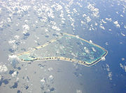
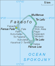
located at 171° 15' West, 9° 25' South in the Tokelau
Tokelau
Tokelau is a territory of New Zealand in the South Pacific Ocean that consists of three tropical coral atolls with a combined land area of 10 km2 and a population of approximately 1,400...
Group. The actual land area is only about 3 km², consisting of islets on a coral reef surrounding a central lagoon of some 45 km². According to the 2006 census 483 people officially live on Fakaofo (however just 370 were present at census night). Of those present 70% belong to the Congregational Church
Congregational church
Congregational churches are Protestant Christian churches practicing Congregationalist church governance, in which each congregation independently and autonomously runs its own affairs....
and 22% to the Catholic Church.
Overview
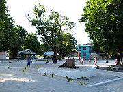
The main settlement on the island is Fale on Fale IsletFale, Tokelau
Fale is an islet of the Fakaofo island group of Tokelau. It is the location of the main settlement in the group.-References:*...
, towards the western side of the atoll. Two kilometers to the west of it is the relatively large Fenua Fala
Fenua Fala
Fenua Fala is an islet of the Fakaofo island group of Tokelau. A settlement was established there in 1960.-References:*...
Islet, where a second settlement had been established in 1960. Other islets in the group include Teafua
Teafua
-References:*...
, Nukumatau
Nukumatau
-References:*...
, Nukulakia
Nukulakia
-References:*...
, Fenua Loa
Fenua Loa
-References:*...
, Saumatafanga
Saumatafanga
-References:*...
, Motu Akea
Motu Akea
-References:*...
, Matangi
Matangi, Tokelau
-References:*...
, Lalo
Lalo, Tokelau
-References:*...
, and Mulifenua
Mulifenua
-References:*...
.
Fakaofo's Council of Elders is made up of citizens over the age of 60.
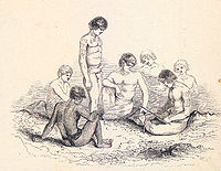
Previously known as Bowditch for its discoverer, this island was visited by the American ship Peacock which was part of the first American voyage of discovery~ The United States Navy Exploring Expedition, or simply the Ex Ex, 1838–1842, Charles Wikes Commanding. Nathaniel Bowditch(1773–1838) was a noted American navigator who wrote a famous two volume eipitome of Navigation that is still used and published today by the Defense Mapping Agency/Topography Center; U.S Printing Office,Washington, D.C. This Epitome is an encyclopedic work on everything to do with Navigation and Sailing.
The author of a first hand account entitled Twenty Years Before The Mast, one Charles Erskine, wrote that "The people found on this island had no knowledge of fire, which I believe, is the only instance of the kind on record."
Twenty Years Before The Mast, George W. Jacobs & Co, Philadelphia, 1896. This book should not be confused with a famous book with a similar title by Richard Henry Dana, Jr.
Richard Henry Dana, Jr.
Richard Henry Dana Jr. was an American lawyer and politician from Massachusetts, a descendant of an eminent colonial family who gained renown as the author of the American classic, the memoir Two Years Before the Mast...
which tells about hide trading on the California coast in the early 19th century.
In a village on the island is a monument which is a coral slab personifying Tui Tokelau
Tui Tokelau
Tui Tokelau is a god worshipped in Tokelau in the Pacific. Before the arrival of Christianity in the islands, Tui Tokelau was the primary god along with the usual pantheon of Polynesian gods. The village of Fakaofo on Fakaofo atoll has a monumental coral slab personifying Tui Tokelau.-References:*...
, a god once worshipped in the islands.
Between 1856 and 1979, the United States claimed that it held sovereignty over the island and the other Tokelauan atolls. In 1979, the U.S. conceded that Tokelau was under New Zealand sovereignty, and a maritime boundary
Maritime boundary
Maritime boundary is a conceptual means of division of the water surface of the planet into maritime areas that are defined through surrounding physical geography or by human geography. As such it usually includes areas of exclusive national rights over the mineral and biological resources,...
between Tokelau and American Samoa
American Samoa
American Samoa is an unincorporated territory of the United States located in the South Pacific Ocean, southeast of the sovereign state of Samoa...
was established by the Treaty of Tokehega
Treaty of Tokehega
The Treaty of Tokehega is a 1980 treaty between New Zealand and the United States that delineates the maritime boundary between Tokelau and American Samoa....
.