

Cyclone Nancy
Encyclopedia
Cyclone Nancy was the second in a series of four severe tropical cyclones to impact the Cook Islands
during February 2005. Forming out of an area of low pressure
on February 10, Nancy quickly organized into a small, but intense, cyclone. By February 14, the storm explosively intensified
into a Category 4 severe tropical cyclone with winds peaking at 175 km/h (110 mph 10-minute winds)The maximum sustained wind
reported by the Regional Specialized Meteorological Center
in Nadi, Fiji are measured by 10-minute standards and a minimum barometric pressure of 935 hPa (mbar). Over the following day, increasing wind shear
rapidly weakened the cyclone and by February 17, it transitioned into an extratropical cyclone
shortly before being absorbed by Cyclone Olaf
.
Already impacted by Cyclone Meena in early February, the Cook Islands sustained significant damage from Cyclone Nancy. Several homes were damaged and destroyed throughout the islands. Downed trees and power lines blocked roads and cut power and minor flooding was reported along coastal areas. Following the impact of the storm, the World Meteorological Organization
retired the name Nancy in May 2006 and replaced it with the name Nat.
within a monsoon
al trough
northeast of Samoa
on February 10. Initially, the system was nearly stationary within an area of weak steering currents, low wind shear
and high sea surface temperature
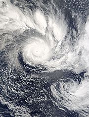
s, exceeding 30 °C (86 °F). On February 11, a trough briefly increased shear over the system and its nearby twin, the precursor to Cyclone Olaf
. By 0600 UTC on February 12, the system's outflow
improved and a small area of deep convection
, known as the central dense overcast, developed over the center of circulation
. Later that day, the Regional Specialized Meteorological Centre
(RSMC) in Nadi, Fiji upgraded the system to a Category 1 cyclone and gave it the name Nancy while it was located about 485 km (300 mi) east-northeast of Pago Pago, American Samoa
. By this time, the Joint Typhoon Warning Center
(JTWC) had also begun issuing advisories on the storm, designating it as Tropical Cyclone 18P.
The storm had undertaken a slow northeast motion early on February 13 before turning southeast in response to a mid-level ridge
located northeast of the cyclone. Convective banding features
developed close to the center of circulation as the storm began to undergo explosive intensification
. Around 1200 UTC, the storm attained Severe Tropical Cyclone status as winds reached 120 km/h (75 mph 10-minute winds) and a small, irregularly shaped, eye
began to develop. The JTWC, however, assessed Nancy to have been substantially weaker until 0000 UTC on February 14, at which time they reported a 95 km/h (60 mph) increase in winds, attaining minimal Category 3 status on the Saffir–Simpson Hurricane Scale.
By 1200 UTC on February 14, Nancy attained its peak intensity with winds of 175 km/h (110 mph 10-minute winds) and a barometric pressure of 935 hPa (mbar). Shortly after, the JTWC assessed Nancy to have peaked with winds of 230 km/h (145 mph 1-minute winds). Increasing forward motion to the southeast and increasing wind shear caused Nancy to weaken. Early on February 15, the storm passed directly over Manuae
. Continued weakening took place as a trough approached from the southwest. By February 16, Nancy weakened below hurricane intensity and turned to the southwest as it began to undergo a Fujiwhara interaction with Cyclone Olaf to the north.
Strong shear associated with the outflow of Cyclone Olaf caused all convection associated with Nancy to be displaced to the southwest on February 16. Early on February 17, Nancy transitioned into an extratropical cyclone
as it entered the area of responsibility of the Tropical cyclone warning centre
(TCWC) in Wellington, New Zealand. Shortly after, the low was absorbed into the larger circulation of Olaf. However, TCWC Wellington continued to monitor Nancy as a separate system until 1200 UTC on February 18.
in Nadi, Fiji uses 10-minute sustained winds for its tropical cyclone tracking information, while the Joint Typhoon Warning Center
uses 1-minute sustained winds. The conversion factor between the two is 1.14. RSMC Nadi's peak intensity for Nancy was 175 km/h (110 mph) 10-minute sustained, or 205 km/h (125 mph) 1-minute sustained. The JTWC's peak intensity for Nancy was 230 km/h (145 mph) 1-minute sustained, or 205 km/h (125 mph) 10-minute sustained.
. Later that day, four additional countries were placed under watches and warnings. A gale watch was declared for Samoa
and strong wind warnings were raised in Tuvalu
, Tokelau
and the Cook Islands
. On February 14, a tropical cyclone alert was declared for the southern Cook Islands. Additionally, Niue
was placed under a strong wind warning. Later that day, Wallis and Futuna
were placed under a strong wind warning. On February 15, a hurricane warning was issued for the southern Cook Islands as Nancy tracked through the archipelago.
Already impacted by Cyclone Meena just a week prior, residents in the Cook Islands heeded warnings and evacuated to emergency shelters. Coastal areas where seawalls had been damaged or destroyed by Meena were of particular interest to warning centers and urged all people in the vicinity of them to evacuate to a nearby shelter. On Aitutake, all preparations were completed by February 15. Tourists were relocated from hotels to on of six shelters set up throughout the island. An estimated 100 people reportedly evacuated to shelters out of the 2,000 that live on the island. Radio broadcasts urging people to move to shelters were broadcast all day and the local cyclone center had all staff on standby. Eight shelters were opened on Rarotonga
by this time. All residents were evacuated from low-lying areas as large swells were anticipated to inundate those areas. Schools throughout the Cook Islands were closed prior to the cyclone and would remain closed for several more days. Many of the south Pacific islands were in a "critically dangerous situation" due to the quick succession of cyclones.
 Cyclone Nancy caused substantial damage throughout the Cook Islands. On Atiu
, all communication to the island was cut as power lines were downed throughout the island. Winds on the island gusted up to 241 km/h (149.8 mph). Four homes were destroyed on the island and at least 80 trees were downed, blocking all roads. Several homes had their roofs blown off, coconut trees were downed, road were covered in debris and heavy rains fell throughout all the islands. Numerous trees were downed across Manuae
and Mauke
by the storm's high winds. Four homes were destroyed on Mauke. Three homes were destroyed on Mitiaro
and trees blocked all roads on the island.
On Rarotonga
, several bridges were damaged by high waves produced by the cyclone. Schools, churches, and restaurants were damaged by wind gusts up to 150 km/h (93.2 mph) throughout the island. Fifteen temporarily shelters constructed after Cyclone Meena were also destroyed. Damages caused by the storm to the Avana Marina Condominiums forced the owners to close them until mid-April to allow for reconstruction and renovation. The highest winds were recorded in the southern portions of the island chain, with a wind gust of 259 km/h (160.9 mph) being recorded on Mangaia
. Up to 100% of the seasonal crop harvest was lost due to Cyclone Nancy.
In the wake of all four cyclones, the Cook Islands requested international assistance. Funding to repair damages from the storms reached $7.87 million. The Red Cross provided relief items, such as blankets and lanterns worth $35,200; the Pacific Forum provided food, fuel, and logistical support worth $32,000; the Government of China
donated $19,200 in post-disaster funds; $32,000 in funding was provided by the United Nations Development Programme
; contributions from the Australian Agency for International Development
and the New Zealand Agency for International Development
amounted to $862,570, consisting of fuel, shelter, relief items, and disaster funds; the Government of Australia
provided $128,000 wort of fuel and equipment; lastly, the Government of France
deployed military teams with recovery supplies and tents. The European Union
also supplied £200,000 ($280,000) in relief funds.
Since Nancy caused substantial damage throughout the Cook Islands, the name was retired from "Naming List A" for the South Pacific basin and was replaced with Nat. The three other cyclones that impacted the region, Meena, Olaf and Percy, were also retired and replaced by Mal, Olof and Pita respectively.
Cook Islands
The Cook Islands is a self-governing parliamentary democracy in the South Pacific Ocean in free association with New Zealand...
during February 2005. Forming out of an area of low pressure
Low pressure area
A low-pressure area, or "low", is a region where the atmospheric pressure at sea level is below that of surrounding locations. Low-pressure systems form under areas of wind divergence which occur in upper levels of the troposphere. The formation process of a low-pressure area is known as...
on February 10, Nancy quickly organized into a small, but intense, cyclone. By February 14, the storm explosively intensified
Rapid deepening
Rapid deepening, also known as rapid intensification, is a meteorological condition that occurs when the minimum sea-level atmospheric pressure of a tropical cyclone decreases drastically in a short period of time. The National Weather Service describes rapid deepening as a decrease of...
into a Category 4 severe tropical cyclone with winds peaking at 175 km/h (110 mph 10-minute winds)The maximum sustained wind
Maximum sustained wind
The maximum sustained winds associated with a tropical cyclone are a common indicator of the intensity of the storm. Within a mature tropical cyclone, they are found within the eyewall at a distance defined as the radius of maximum wind, or RMW. Unlike gusts, the value of these winds are...
reported by the Regional Specialized Meteorological Center
Regional Specialized Meteorological Center
A Regional Specialized Meteorological Centre is responsible for the distribution of information, advisories, and warnings regarding the specific program they have a part of, agreed by consensus at the World Meteorological Organization as part of the World Weather Watch.-Tropical...
in Nadi, Fiji are measured by 10-minute standards and a minimum barometric pressure of 935 hPa (mbar). Over the following day, increasing wind shear
Wind shear
Wind shear, sometimes referred to as windshear or wind gradient, is a difference in wind speed and direction over a relatively short distance in the atmosphere...
rapidly weakened the cyclone and by February 17, it transitioned into an extratropical cyclone
Extratropical cyclone
Extratropical cyclones, sometimes called mid-latitude cyclones or wave cyclones, are a group of cyclones defined as synoptic scale low pressure weather systems that occur in the middle latitudes of the Earth having neither tropical nor polar characteristics, and are connected with fronts and...
shortly before being absorbed by Cyclone Olaf
Cyclone Olaf
Cyclone Olaf was the sixth cyclone to form in the Southwest Pacific Ocean during the 2004-05 South Pacific cyclone season. Olaf was also one of three simultaneous cyclones to form during the 2004-05 season, forming 21 hours after Cyclone Nancy formed to the east. A powerful Category 5 cyclone,...
.
Already impacted by Cyclone Meena in early February, the Cook Islands sustained significant damage from Cyclone Nancy. Several homes were damaged and destroyed throughout the islands. Downed trees and power lines blocked roads and cut power and minor flooding was reported along coastal areas. Following the impact of the storm, the World Meteorological Organization
World Meteorological Organization
The World Meteorological Organization is an intergovernmental organization with a membership of 189 Member States and Territories. It originated from the International Meteorological Organization , which was founded in 1873...
retired the name Nancy in May 2006 and replaced it with the name Nat.
Meteorological history
Cyclone Nancy originated out of a broad area of low pressureLow pressure area
A low-pressure area, or "low", is a region where the atmospheric pressure at sea level is below that of surrounding locations. Low-pressure systems form under areas of wind divergence which occur in upper levels of the troposphere. The formation process of a low-pressure area is known as...
within a monsoon
Monsoon
Monsoon is traditionally defined as a seasonal reversing wind accompanied by corresponding changes in precipitation, but is now used to describe seasonal changes in atmospheric circulation and precipitation associated with the asymmetric heating of land and sea...
al trough
Trough (meteorology)
A trough is an elongated region of relatively low atmospheric pressure, often associated with fronts.Unlike fronts, there is not a universal symbol for a trough on a weather chart. The weather charts in some countries or regions mark troughs by a line. In the United States, a trough may be marked...
northeast of Samoa
Samoa
Samoa , officially the Independent State of Samoa, formerly known as Western Samoa is a country encompassing the western part of the Samoan Islands in the South Pacific Ocean. It became independent from New Zealand in 1962. The two main islands of Samoa are Upolu and one of the biggest islands in...
on February 10. Initially, the system was nearly stationary within an area of weak steering currents, low wind shear
Wind shear
Wind shear, sometimes referred to as windshear or wind gradient, is a difference in wind speed and direction over a relatively short distance in the atmosphere...
and high sea surface temperature
Sea surface temperature
Sea surface temperature is the water temperature close to the oceans surface. The exact meaning of surface varies according to the measurement method used, but it is between and below the sea surface. Air masses in the Earth's atmosphere are highly modified by sea surface temperatures within a...
s, exceeding 30 °C (86 °F). On February 11, a trough briefly increased shear over the system and its nearby twin, the precursor to Cyclone Olaf
Cyclone Olaf
Cyclone Olaf was the sixth cyclone to form in the Southwest Pacific Ocean during the 2004-05 South Pacific cyclone season. Olaf was also one of three simultaneous cyclones to form during the 2004-05 season, forming 21 hours after Cyclone Nancy formed to the east. A powerful Category 5 cyclone,...
. By 0600 UTC on February 12, the system's outflow
Outflow (meteorology)
Outflow, in meteorology, is air that flows outwards from a storm system. It is associated with ridging, or anticyclonic flow. In the low levels of the troposphere, outflow radiates from thunderstorms in the form of a wedge of rain-cooled air, which is visible as a thin rope-like cloud on weather...
improved and a small area of deep convection
Atmospheric convection
Atmospheric convection is the result of a parcel-environment instability, or temperature difference, layer in the atmosphere. Different lapse rates within dry and moist air lead to instability. Mixing of air during the day which expands the height of the planetary boundary layer leads to...
, known as the central dense overcast, developed over the center of circulation
Eye (cyclone)
The eye is a region of mostly calm weather found at the center of strong tropical cyclones. The eye of a storm is a roughly circular area and typically 30–65 km in diameter. It is surrounded by the eyewall, a ring of towering thunderstorms where the second most severe weather of a cyclone...
. Later that day, the Regional Specialized Meteorological Centre
Regional Specialized Meteorological Centre
A Regional Specialized Meteorological Centre is responsible for the distribution of information, advisories, and warnings regarding the specific program they have a part of, agreed by consensus at the World Meteorological Organization as part of the World Weather Watch.-Tropical...
(RSMC) in Nadi, Fiji upgraded the system to a Category 1 cyclone and gave it the name Nancy while it was located about 485 km (300 mi) east-northeast of Pago Pago, American Samoa
Pago Pago, American Samoa
Pago Pago , also spelled ', is the capital of American Samoa. In 2000, its population was 11,500. The city is served by Pago Pago International Airport. Tourism, entertainment, food, and tuna canning are the primary industries here. From 1878 to 1951, this was a coaling and repair station for the...
. By this time, the Joint Typhoon Warning Center
Joint Typhoon Warning Center
The Joint Typhoon Warning Center is a joint United States Navy – United States Air Force task force located at the Naval Maritime Forecast Center in Pearl Harbor, Hawaii...
(JTWC) had also begun issuing advisories on the storm, designating it as Tropical Cyclone 18P.
The storm had undertaken a slow northeast motion early on February 13 before turning southeast in response to a mid-level ridge
Ridge (meteorology)
A ridge is an elongated region of relatively high atmospheric pressure, the opposite of a trough....
located northeast of the cyclone. Convective banding features
Rainband
A rainband is a cloud and precipitation structure associated with an area of rainfall which is significantly elongated. Rainbands can be stratiform or convective, and are generated by differences in temperature. When noted on weather radar imagery, this precipitation elongation is referred to as...
developed close to the center of circulation as the storm began to undergo explosive intensification
Rapid deepening
Rapid deepening, also known as rapid intensification, is a meteorological condition that occurs when the minimum sea-level atmospheric pressure of a tropical cyclone decreases drastically in a short period of time. The National Weather Service describes rapid deepening as a decrease of...
. Around 1200 UTC, the storm attained Severe Tropical Cyclone status as winds reached 120 km/h (75 mph 10-minute winds) and a small, irregularly shaped, eye
Eye (cyclone)
The eye is a region of mostly calm weather found at the center of strong tropical cyclones. The eye of a storm is a roughly circular area and typically 30–65 km in diameter. It is surrounded by the eyewall, a ring of towering thunderstorms where the second most severe weather of a cyclone...
began to develop. The JTWC, however, assessed Nancy to have been substantially weaker until 0000 UTC on February 14, at which time they reported a 95 km/h (60 mph) increase in winds, attaining minimal Category 3 status on the Saffir–Simpson Hurricane Scale.
By 1200 UTC on February 14, Nancy attained its peak intensity with winds of 175 km/h (110 mph 10-minute winds) and a barometric pressure of 935 hPa (mbar). Shortly after, the JTWC assessed Nancy to have peaked with winds of 230 km/h (145 mph 1-minute winds). Increasing forward motion to the southeast and increasing wind shear caused Nancy to weaken. Early on February 15, the storm passed directly over Manuae
Manuae
Manuae is an uninhabited atoll in the southern group of the Cook Islands, 100 kilometres south-east of Aitutaki. It is administratively part of Aitutaki, but does not belong to any district or tapere of Aitutaki. It is, however, part of Arutanga-Reureu-Nikaupara Constituency.Manuae is a true atoll...
. Continued weakening took place as a trough approached from the southwest. By February 16, Nancy weakened below hurricane intensity and turned to the southwest as it began to undergo a Fujiwhara interaction with Cyclone Olaf to the north.
Strong shear associated with the outflow of Cyclone Olaf caused all convection associated with Nancy to be displaced to the southwest on February 16. Early on February 17, Nancy transitioned into an extratropical cyclone
Extratropical cyclone
Extratropical cyclones, sometimes called mid-latitude cyclones or wave cyclones, are a group of cyclones defined as synoptic scale low pressure weather systems that occur in the middle latitudes of the Earth having neither tropical nor polar characteristics, and are connected with fronts and...
as it entered the area of responsibility of the Tropical cyclone warning centre
Regional Specialized Meteorological Center
A Regional Specialized Meteorological Centre is responsible for the distribution of information, advisories, and warnings regarding the specific program they have a part of, agreed by consensus at the World Meteorological Organization as part of the World Weather Watch.-Tropical...
(TCWC) in Wellington, New Zealand. Shortly after, the low was absorbed into the larger circulation of Olaf. However, TCWC Wellington continued to monitor Nancy as a separate system until 1200 UTC on February 18.
Differences among warning centers
The Regional Specialized Meteorological CenterRegional Specialized Meteorological Center
A Regional Specialized Meteorological Centre is responsible for the distribution of information, advisories, and warnings regarding the specific program they have a part of, agreed by consensus at the World Meteorological Organization as part of the World Weather Watch.-Tropical...
in Nadi, Fiji uses 10-minute sustained winds for its tropical cyclone tracking information, while the Joint Typhoon Warning Center
Joint Typhoon Warning Center
The Joint Typhoon Warning Center is a joint United States Navy – United States Air Force task force located at the Naval Maritime Forecast Center in Pearl Harbor, Hawaii...
uses 1-minute sustained winds. The conversion factor between the two is 1.14. RSMC Nadi's peak intensity for Nancy was 175 km/h (110 mph) 10-minute sustained, or 205 km/h (125 mph) 1-minute sustained. The JTWC's peak intensity for Nancy was 230 km/h (145 mph) 1-minute sustained, or 205 km/h (125 mph) 10-minute sustained.
Preparations
Upon being named Nancy on February 13, a gale warning was put in place for American SamoaAmerican Samoa
American Samoa is an unincorporated territory of the United States located in the South Pacific Ocean, southeast of the sovereign state of Samoa...
. Later that day, four additional countries were placed under watches and warnings. A gale watch was declared for Samoa
Samoa
Samoa , officially the Independent State of Samoa, formerly known as Western Samoa is a country encompassing the western part of the Samoan Islands in the South Pacific Ocean. It became independent from New Zealand in 1962. The two main islands of Samoa are Upolu and one of the biggest islands in...
and strong wind warnings were raised in Tuvalu
Tuvalu
Tuvalu , formerly known as the Ellice Islands, is a Polynesian island nation located in the Pacific Ocean, midway between Hawaii and Australia. Its nearest neighbours are Kiribati, Nauru, Samoa and Fiji. It comprises four reef islands and five true atolls...
, Tokelau
Tokelau
Tokelau is a territory of New Zealand in the South Pacific Ocean that consists of three tropical coral atolls with a combined land area of 10 km2 and a population of approximately 1,400...
and the Cook Islands
Cook Islands
The Cook Islands is a self-governing parliamentary democracy in the South Pacific Ocean in free association with New Zealand...
. On February 14, a tropical cyclone alert was declared for the southern Cook Islands. Additionally, Niue
Niue
Niue , is an island country in the South Pacific Ocean. It is commonly known as the "Rock of Polynesia", and inhabitants of the island call it "the Rock" for short. Niue is northeast of New Zealand in a triangle between Tonga to the southwest, the Samoas to the northwest, and the Cook Islands to...
was placed under a strong wind warning. Later that day, Wallis and Futuna
Wallis and Futuna
Wallis and Futuna, officially the Territory of the Wallis and Futuna Islands , is a Polynesian French island territory in the South Pacific between Tuvalu to the northwest, Rotuma of Fiji to the west, the main part of Fiji to the southwest, Tonga to the southeast,...
were placed under a strong wind warning. On February 15, a hurricane warning was issued for the southern Cook Islands as Nancy tracked through the archipelago.
Already impacted by Cyclone Meena just a week prior, residents in the Cook Islands heeded warnings and evacuated to emergency shelters. Coastal areas where seawalls had been damaged or destroyed by Meena were of particular interest to warning centers and urged all people in the vicinity of them to evacuate to a nearby shelter. On Aitutake, all preparations were completed by February 15. Tourists were relocated from hotels to on of six shelters set up throughout the island. An estimated 100 people reportedly evacuated to shelters out of the 2,000 that live on the island. Radio broadcasts urging people to move to shelters were broadcast all day and the local cyclone center had all staff on standby. Eight shelters were opened on Rarotonga
Rarotonga
Rarotonga is the most populous island of the Cook Islands, with a population of 14,153 , out of the country's total population of 19,569.The Cook Islands' Parliament buildings and international airport are on Rarotonga...
by this time. All residents were evacuated from low-lying areas as large swells were anticipated to inundate those areas. Schools throughout the Cook Islands were closed prior to the cyclone and would remain closed for several more days. Many of the south Pacific islands were in a "critically dangerous situation" due to the quick succession of cyclones.
Impact and aftermath
Atiu
Atiu, also known as Enuamanu , is an island lying at 187 km to the northeast of Rarotonga, in the Southern Islands group of the Cook Islands Archipelago.-Geography:...
, all communication to the island was cut as power lines were downed throughout the island. Winds on the island gusted up to 241 km/h (149.8 mph). Four homes were destroyed on the island and at least 80 trees were downed, blocking all roads. Several homes had their roofs blown off, coconut trees were downed, road were covered in debris and heavy rains fell throughout all the islands. Numerous trees were downed across Manuae
Manuae
Manuae is an uninhabited atoll in the southern group of the Cook Islands, 100 kilometres south-east of Aitutaki. It is administratively part of Aitutaki, but does not belong to any district or tapere of Aitutaki. It is, however, part of Arutanga-Reureu-Nikaupara Constituency.Manuae is a true atoll...
and Mauke
Mauke
Mauke is a raised atoll island, the eastern most of the Cook Islands.-Geography:...
by the storm's high winds. Four homes were destroyed on Mauke. Three homes were destroyed on Mitiaro
Mitiaro
Mitiaro, the fourth island in the Cook Islands group, is of volcanic origin. Standing in water 14,750 feet deep it is four miles across at its widest point.-Geography:...
and trees blocked all roads on the island.
On Rarotonga
Rarotonga
Rarotonga is the most populous island of the Cook Islands, with a population of 14,153 , out of the country's total population of 19,569.The Cook Islands' Parliament buildings and international airport are on Rarotonga...
, several bridges were damaged by high waves produced by the cyclone. Schools, churches, and restaurants were damaged by wind gusts up to 150 km/h (93.2 mph) throughout the island. Fifteen temporarily shelters constructed after Cyclone Meena were also destroyed. Damages caused by the storm to the Avana Marina Condominiums forced the owners to close them until mid-April to allow for reconstruction and renovation. The highest winds were recorded in the southern portions of the island chain, with a wind gust of 259 km/h (160.9 mph) being recorded on Mangaia
Mangaia
Mangaia is the most southerly of the Cook Islands and the second largest, after Rarotonga.-Geography:...
. Up to 100% of the seasonal crop harvest was lost due to Cyclone Nancy.
In the wake of all four cyclones, the Cook Islands requested international assistance. Funding to repair damages from the storms reached $7.87 million. The Red Cross provided relief items, such as blankets and lanterns worth $35,200; the Pacific Forum provided food, fuel, and logistical support worth $32,000; the Government of China
Government of the People's Republic of China
All power within the government of the People's Republic of China is divided among three bodies: the People's Republic of China, State Council, and the People's Liberation Army . This article is concerned with the formal structure of the state, its departments and their responsibilities...
donated $19,200 in post-disaster funds; $32,000 in funding was provided by the United Nations Development Programme
United Nations Development Programme
The United Nations Development Programme is the United Nations' global development network. It advocates for change and connects countries to knowledge, experience and resources to help people build a better life. UNDP operates in 177 countries, working with nations on their own solutions to...
; contributions from the Australian Agency for International Development
Australian Agency for International Development
AusAID is the Australian Government agency responsible for managing Australia's overseas aid program...
and the New Zealand Agency for International Development
New Zealand Agency for International Development
The New Zealand Agency for International Development is the New Zealand Government's international aid and development agency. NZAID is a semi-autonomous body within the New Zealand Ministry of Foreign Affairs and Trade . Its Māori name is Nga Hoe Tuputupu-mai-tawhiti – the paddles that bring...
amounted to $862,570, consisting of fuel, shelter, relief items, and disaster funds; the Government of Australia
Government of Australia
The Commonwealth of Australia is a federal constitutional monarchy under a parliamentary democracy. The Commonwealth of Australia was formed in 1901 as a result of an agreement among six self-governing British colonies, which became the six states...
provided $128,000 wort of fuel and equipment; lastly, the Government of France
Government of France
The government of the French Republic is a semi-presidential system determined by the French Constitution of the fifth Republic. The nation declares itself to be an "indivisible, secular, democratic, and social Republic"...
deployed military teams with recovery supplies and tents. The European Union
European Union
The European Union is an economic and political union of 27 independent member states which are located primarily in Europe. The EU traces its origins from the European Coal and Steel Community and the European Economic Community , formed by six countries in 1958...
also supplied £200,000 ($280,000) in relief funds.
Since Nancy caused substantial damage throughout the Cook Islands, the name was retired from "Naming List A" for the South Pacific basin and was replaced with Nat. The three other cyclones that impacted the region, Meena, Olaf and Percy, were also retired and replaced by Mal, Olof and Pita respectively.