

Congo Pedicle
Encyclopedia
Panhandle
A panhandle is an informal geographic term for an elongated arm-like protrusion of a geo-political entity, such as a subnational entity or a sovereign state.-Term:...
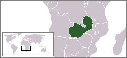
of the Katanga Province
Katanga Province
Katanga Province is one of the provinces of the Democratic Republic of the Congo. Between 1971 and 1997, its official name was Shaba Province. Under the new constitution, the province was to be replaced by four smaller provinces by February 2009; this did not actually take place.Katanga's regional...
of the Democratic Republic of Congo which sticks into neighbouring Zambia
Zambia
Zambia , officially the Republic of Zambia, is a landlocked country in Southern Africa. The neighbouring countries are the Democratic Republic of the Congo to the north, Tanzania to the north-east, Malawi to the east, Mozambique, Zimbabwe, Botswana and Namibia to the south, and Angola to the west....
almost dividing it into two lobes, like the wings of a butterfly. In area the pedicle is similar in size to Wales
Wales
Wales is a country that is part of the United Kingdom and the island of Great Britain, bordered by England to its east and the Atlantic Ocean and Irish Sea to its west. It has a population of three million, and a total area of 20,779 km²...
or New Jersey
New Jersey
New Jersey is a state in the Northeastern and Middle Atlantic regions of the United States. , its population was 8,791,894. It is bordered on the north and east by the state of New York, on the southeast and south by the Atlantic Ocean, on the west by Pennsylvania and on the southwest by Delaware...
. 'Pedicle
Pedicle
Pedicle or pedicel may refer to:*Pedicle of vertebral arch, the segment between the transverse process and the vertebral body, and is often used as a radiographic marker and entry point in vertebroplasty and kyphoplasty procedures...
' is used in the sense of 'a little foot'. 'Congo Pedicle' or 'the Pedicle' is also used to refer to the Congo Pedicle road
Congo Pedicle road
The Congo Pedicle road crosses the Congolese territory of the Congo Pedicle and was constructed by and is maintained by Zambia to connect its Copperbelt and Luapula Provinces...
which crosses it.
The Congo Pedicle is an example of the arbitrary boundaries imposed by European powers
Europe
Europe is, by convention, one of the world's seven continents. Comprising the westernmost peninsula of Eurasia, Europe is generally 'divided' from Asia to its east by the watershed divides of the Ural and Caucasus Mountains, the Ural River, the Caspian and Black Seas, and the waterways connecting...
on Africa
Africa
Africa is the world's second largest and second most populous continent, after Asia. At about 30.2 million km² including adjacent islands, it covers 6% of the Earth's total surface area and 20.4% of the total land area...
in the wake of the Scramble for Africa
Scramble for Africa
The Scramble for Africa, also known as the Race for Africa or Partition of Africa was a process of invasion, occupation, colonization and annexation of African territory by European powers during the New Imperialism period, between 1881 and World War I in 1914...
, which were "drawn by Europeans, for Europeans, and, apart from a some localized detail, paid scant regard to Africa, let alone Africans." This article relates how the Pedicle came into being. For details of the road see the Congo Pedicle road
Congo Pedicle road
The Congo Pedicle road crosses the Congolese territory of the Congo Pedicle and was constructed by and is maintained by Zambia to connect its Copperbelt and Luapula Provinces...
article.
British and Belgian territorial claims
Cecil Rhodes's British South Africa CompanyBritish South Africa Company
The British South Africa Company was established by Cecil Rhodes through the amalgamation of the Central Search Association and the Exploring Company Ltd., receiving a royal charter in 1889...
approached Katanga from the south, the Belgian
Belgium
Belgium , officially the Kingdom of Belgium, is a federal state in Western Europe. It is a founding member of the European Union and hosts the EU's headquarters, and those of several other major international organisations such as NATO.Belgium is also a member of, or affiliated to, many...
King Leopold II
Leopold II of Belgium
Leopold II was the second king of the Belgians. Born in Brussels the second son of Leopold I and Louise-Marie of Orléans, he succeeded his father to the throne on 17 December 1865 and remained king until his death.Leopold is chiefly remembered as the founder and sole owner of the Congo Free...
's Congo Free State
Congo Free State
The Congo Free State was a large area in Central Africa which was privately controlled by Leopold II, King of the Belgians. Its origins lay in Leopold's attracting scientific, and humanitarian backing for a non-governmental organization, the Association internationale africaine...
(CFS) approached from the northwest. Southeast Katanga was controlled by the Yeke or Garanganze kingdom of Msiri based at Bunkeya (see map), and the BSAC and CFS competed to sign treaties with him, while he tried to play the one off against the other. For more detail and the story of how a CFS expedition led by a Canadian killed Msiri in December 1891, see the article on Msiri.
After Msiri's death the CFS was faster off the mark to consolidate their claim to Msiri's territory called 'Garanganza', and later Katanga, west up to the Luapula. Since 1885 they already had claimed land north of the Congo-Zambezi watershed
Water divide
A drainage divide, water divide, divide or watershed is the line separating neighbouring drainage basins...
. The BSAC were left with the land south of the watershed and east of the Luapula. The 1884–5 Berlin Conference
Berlin Conference
The Berlin Conference of 1884–85 regulated European colonization and trade in Africa during the New Imperialism period, and coincided with Germany's sudden emergence as an imperial power...
was organised by Germany
Germany
Germany , officially the Federal Republic of Germany , is a federal parliamentary republic in Europe. The country consists of 16 states while the capital and largest city is Berlin. Germany covers an area of 357,021 km2 and has a largely temperate seasonal climate...
to resolve the outcome of the Scramble for Africa
Scramble for Africa
The Scramble for Africa, also known as the Race for Africa or Partition of Africa was a process of invasion, occupation, colonization and annexation of African territory by European powers during the New Imperialism period, between 1881 and World War I in 1914...
. It did not set the actual boundaries but agreed areas of influence, including the CFS's control over the Congo. Detailed borders were left to bilateral negotiations.
Negotiating borders
The main problem of both the Belgian and British sides over the southeast Katanga border was the lack of an obvious geographical feature for the border to follow, as the Congo-Zambezi watershed and the Luapula do not meet. There is a gap between them and, separated by a distance of 70 to 150 km they run in an arc curving northeast, running almost parallel but gradually getting closer, and would reach the highlands between Lakes TanganyikaLake Tanganyika
Lake Tanganyika is an African Great Lake. It is estimated to be the second largest freshwater lake in the world by volume, and the second deepest, after Lake Baikal in Siberia; it is also the world's longest freshwater lake...
and Nyasa
Lake Malawi
Lake Malawi , is an African Great Lake and the southernmost lake in the Great Rift Valley system of East Africa. This lake, the third largest in Africa and the eighth largest lake in the world, is located between Malawi, Mozambique, and Tanzania...
if the Chambeshi River
Chambeshi River
The Chambeshi River of northeastern Zambia is the most remote headstream of the Congo River and therefore considered its source...
were accepted as being the same river as the Luapula.
From the British point of view, the obvious choice for the border is the base of the salient, a southwest to northeast line from the watershed to the Luapula. Failing agreement on that, a second option would be to continue southwards the line of the Luapula-Lake Mweru
Lake Mweru
Lake Mweru is a freshwater lake on the longest arm of Africa's second-longest river, the Congo. Located on the border between Zambia and Democratic Republic of the Congo, it makes up 110 km of the total length of the Congo, lying between its Luapula River and Luvua River segments.Mweru...
valley (longitude
Longitude
Longitude is a geographic coordinate that specifies the east-west position of a point on the Earth's surface. It is an angular measurement, usually expressed in degrees, minutes and seconds, and denoted by the Greek letter lambda ....
28° 35' E) which forms the longest north-south part of border, until it intersects the Congo-Zambezi watershed. So all of the country immediately east of a north-south line through Ndola
Ndola
Ndola is the third largest city in Zambia, with a population of 495,000 . It is the industrial, commercial, on the Copperbelt, Zambia's copper-mining region, and capital of Copperbelt Province. It is also the commercial capital city of Zambia and has one of the three international airports, others...
would then be in Northern Rhodesia. But the Belgians hoped for access to the rich game areas of the Bangweulu wetlands and pressed for the borders to stick to the river and watershed. In negotiations for a treaty some 'trading' of territories in northeast Congo, Sudan
Sudan
Sudan , officially the Republic of the Sudan , is a country in North Africa, sometimes considered part of the Middle East politically. It is bordered by Egypt to the north, the Red Sea to the northeast, Eritrea and Ethiopia to the east, South Sudan to the south, the Central African Republic to the...
and Uganda
Uganda
Uganda , officially the Republic of Uganda, is a landlocked country in East Africa. Uganda is also known as the "Pearl of Africa". It is bordered on the east by Kenya, on the north by South Sudan, on the west by the Democratic Republic of the Congo, on the southwest by Rwanda, and on the south by...
was involved. There was also the question of how far east into the Bangweulu swamps and floodplain the Pedicle should extend. The King of Italy was called in to adjudicate and he drew a north-south line (a line of longitude) through a point on the map where the Luapula was thought to exit from the Lake Bangweulu swamps, and finally the Pedicle was born: 70 to 100 km wide and about 200 km long, ending in a very stubby toe, but (from the Zambian point of view) it could have been even worse, like a clown's shoe. Africans were not consulted.
Anglo Belgian Agreement of 12 May 1884
The agreement was incorporated into this larger treaty which dealt mainly with EquatoriaEquatoria
Equatoria is a region in the south of present-day South Sudan along the upper reaches of the White Nile. Originally a province of Egypt, it also contained most of Northern part of present day Uganda including Albert Lake...
.
Anglo-Belgian Boundary Commission 1911–1914
It became apparent as the region was more closely surveyed that on the ground there were a number of problems. The Luapula does not always flow in a single channel, there are islands, swamps, multiple channels and the main channel may change according to the river height. It is particularly confusing south of Bangweulu, where there is not one single clear channel exiting the swamps but a tangled mass of channels in swamps and floodplains tens of kilometres wide, and the Italian King's line of longitude crossed them at multiple points.An Anglo-Belgian Boundary Commission was established in 1911 to survey the boundaries on the ground, resolve the problems and mark the border with posts and timber towers used for triangulation
Triangulation
In trigonometry and geometry, triangulation is the process of determining the location of a point by measuring angles to it from known points at either end of a fixed baseline, rather than measuring distances to the point directly...
. The Italian King's ruler was moved west to a point where it did cut a clearly defined channel in one place. Finally the work was complete in 1914.
Consequences for Northern Rhodesia/Zambia
As a consequence of Katanga attaining the Pedicle, it gained a toehold in the Bangweulu wetlands and potential mineral resources, although as it turned out, the division of the main copper ore body between the Congo and Northern Rhodesia was determined by the Congo-Zambezi watershed and would not have been affected by the existence or otherwise of the Pedicle. It was the BSAC's failure to get Msiri to sign up Garanganza as a British Protectorate which lost the Congolese Copperbelt to Northern Rhodesia, and some in the BSAC complained that the British missionaries Frederick Arnot and Charles SwanCharles Swan
Charles Swan was a reluctant buccaneer, killed 1690.Captain Swan was forced into piracy by his crew in the 1680s, and proceeded to write letters to the owners of his ship Cygnet in London, begging them to intercede with James II of England for his pardon - even as he looted his way up and down the...
could have done more to help, although their Plymouth Brethren
Plymouth Brethren
The Plymouth Brethren is a conservative, Evangelical Christian movement, whose history can be traced to Dublin, Ireland, in the late 1820s. Although the group is notable for not taking any official "church name" to itself, and not having an official clergy or liturgy, the title "The Brethren," is...
mission had a policy of not being involved in politics. Once Msiri was killed by the CFS it was too late to try again, and consequently the leader of CFS expedition responsible, Canadian Captain William Stairs
William Grant Stairs
William Grant Stairs was a Canadian-British explorer, soldier, and adventurer who had a leading role in two of the most controversial expeditions in the history of the colonisation of Africa.-Education:...
was viewed by some in Northern Rhodesia as a traitor to the British Empire
British Empire
The British Empire comprised the dominions, colonies, protectorates, mandates and other territories ruled or administered by the United Kingdom. It originated with the overseas colonies and trading posts established by England in the late 16th and early 17th centuries. At its height, it was the...
.
Strategic issues for Zambia
The problems for Zambia did not emerge for another 50 years, with the Katanga crisis of 1961. The Pedicle cuts off the Luapula ProvinceLuapula Province
Luapula Province is one of Zambia's nine provinces, and is located in the north of the country. The provincial capital is Mansa. Luapula Province was named after the Luapula River....
and the western part of the Northern Province
Northern Province, Zambia
Northern Province is one of Zambia's nine provinces. It covers approximately one fifth of Zambia in land area. The provincial capital is Kasama. The province is made up of 12 districts, namely Kasama , Chilubi, Isoka, Chinsali, Kaputa, Luwingu, Mbala, Mporokoso, Mpika, Mpulungu, Mungwi and Nakonde...
from the country's industrial and commercial hub of the Copperbelt. This is exacerbated by the fact that at the Pedicle's toetip, where the Luapula ostensibly flows out of the Bangweulu system, the river swamps are at least 6 km wide and the floodplain is 60 km wide, making a road impossible with the resources available for most of the 20th Century. The most southerly road
Congo Pedicle road
The Congo Pedicle road crosses the Congolese territory of the Congo Pedicle and was constructed by and is maintained by Zambia to connect its Copperbelt and Luapula Provinces...
possible into Luapula keeping to Zambian territory was pushed, by these circumstances, another 200 km north, going around Lake Bangweulu.
Strategically the Congo Pedicle is an issue for Zambia, though not for DR Congo. As well as affecting communication for about one-quarter of the country with the centre and west, it potentially exposes a greater part of Zambia, which has generally enjoyed peace for more than 100 years, to conflict in Katanga, which has not
Congo Crisis
The Congo Crisis was a period of turmoil in the First Republic of the Congo that began with national independence from Belgium and ended with the seizing of power by Joseph Mobutu...
. Zambia has witnessed violence in Katanga between armed factions and by the military against civilians which occasionally has spilled over into Zambia, or which has affected Zambians travelling on the Pedicle road
Congo Pedicle road
The Congo Pedicle road crosses the Congolese territory of the Congo Pedicle and was constructed by and is maintained by Zambia to connect its Copperbelt and Luapula Provinces...
. At times, it has been closed to them making the huge detour around the north and east of Bangweulu the only option. Secondly cross-border crime and arms smuggling has been a problem in the Copperbelt as has poaching in the Bangweulu wetlands.
See also
- Luapula RiverLuapula RiverThe Luapula River is a section of Africa's second-longest river, the Congo. It is a transnational river forming for nearly all its length part of the border between Zambia and the DR Congo...
- Msiri
- Alfred SharpeAlfred SharpeSir Alfred Sharpe was a professional hunter who became a British colonial administrator and Commissioner of the British Central Africa Protectorate from 1896 until 1910...
- William Grant StairsWilliam Grant StairsWilliam Grant Stairs was a Canadian-British explorer, soldier, and adventurer who had a leading role in two of the most controversial expeditions in the history of the colonisation of Africa.-Education:...
- Katanga ProvinceKatanga ProvinceKatanga Province is one of the provinces of the Democratic Republic of the Congo. Between 1971 and 1997, its official name was Shaba Province. Under the new constitution, the province was to be replaced by four smaller provinces by February 2009; this did not actually take place.Katanga's regional...
- Luapula ProvinceLuapula ProvinceLuapula Province is one of Zambia's nine provinces, and is located in the north of the country. The provincial capital is Mansa. Luapula Province was named after the Luapula River....