

Colorado census statistical areas
Encyclopedia
The United States Office of Management and Budget
{OMB) has defined one Combined Statistical Area
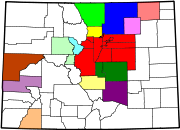
(CSA), seven Metropolitan Statistical Areas (MSAs), and seven Micropolitan Statistical Areas (μSAs) in the State of Colorado. At the 2010 United States Census, 91.86% of Coloradans lived in one of these areas.
 The following table describes the census statistical areas of the State of Colorado with the following information:
United States Office of Management and Budget
The Office of Management and Budget is a Cabinet-level office, and is the largest office within the Executive Office of the President of the United States .The current OMB Director is Jacob Lew.-History:...
{OMB) has defined one Combined Statistical Area
Combined Statistical Area
The United States Office of Management and Budget defines micropolitan and metropolitan statistical areas. Metropolitan and micropolitan statistical areas consist of one or more counties...
(CSA), seven Metropolitan Statistical Areas (MSAs), and seven Micropolitan Statistical Areas (μSAs) in the State of Colorado. At the 2010 United States Census, 91.86% of Coloradans lived in one of these areas.
Table
- The name of the Combined Statistical AreaCombined Statistical AreaThe United States Office of Management and Budget defines micropolitan and metropolitan statistical areas. Metropolitan and micropolitan statistical areas consist of one or more counties...
(CSA), if one is defined - The CSA population as of April 1, 2010, as enumerated by the 2010 United States Census,
- The name of the Core Based Statistical AreaCore based statistical areaA Core Based Statistical Area is a U.S. geographic area defined by the Office of Management and Budget based around an urban center of at least 10,000 people and adjacent areas that are socioeconomically tied to the urban center by commuting. Areas defined on the basis of these standards applied...
(CBSA) - The CBSA population as of April 1, 2010, as enumerated by the 2010 United States Census,
- The name of the countyCounty (United States)In the United States, a county is a geographic subdivision of a state , usually assigned some governmental authority. The term "county" is used in 48 of the 50 states; Louisiana is divided into parishes and Alaska into boroughs. Parishes and boroughs are called "county-equivalents" by the U.S...
- The county population as of April 1, 2010, as enumerated by the 2010 United States Census,
- The county population as of April 1, 2000, as enumerated by the 2000 United States Census,
- The percent county population change from April 1, 2000, to April 1, 2010.
| Combined Statistical Area | 2010 Census | Core Based Statistical Area | 2010 Census | County | 2010 Census | 2000 Census | Change |
|---|---|---|---|---|---|---|---|
| Denver-Aurora-Boulder, CO CSA | 3,090,874 | Denver-Aurora-Broomfield, CO MSA | 2,543,482 | City and County of Denver, Colorado |
|||
| Arapahoe County, Colorado Arapahoe County, Colorado As of the census of 2000, there were 487,967 people, 190,909 households, and 125,809 families residing in the county. The population density was 608 people per square mile . There were 196,835 housing units at an average density of 245 per square mile... |
|||||||
| Jefferson County, Colorado Jefferson County, Colorado Jefferson County , whose slogan is the "Gateway to the Rocky Mountains", is the fourth most populous of the 64 counties of the State of Colorado of the United States. Located along the Front Range of the Rocky Mountains, Jefferson County is adjacent to the west side of the state capital, Denver.... |
|||||||
| Adams County, Colorado Adams County, Colorado Adams County is the fifth most populous of the 64 counties of the state of Colorado of the United States. The United States Census Bureau estimates that the county population was 441,603 in 2010 census, a 21.4% increase since 2000 census. Adams County is named for Alva Adams, Governor of the... |
|||||||
| Douglas County, Colorado Douglas County, Colorado Douglas County is the eighth most populous of the 64 counties of the state of Colorado, in the United States. The county is located midway between Colorado's two largest cities: Denver and Colorado Springs... |
|||||||
| City and County of Broomfield, Colorado Broomfield, Colorado The City and County of Broomfield is a prominent suburb and tier of the Denver metropolitan area in the State of Colorado of the United States. Broomfield has a consolidated city and county government which operates under Article XX, Sections 10-13 of the Constitution of the State of Colorado. The... |
|||||||
| Elbert County, Colorado Elbert County, Colorado Elbert County is the 21st most populous of the 64 counties of the State of Colorado of the United States. The county population was 19,872 at U.S. Census 2000. The county seat is Kiowa... |
|||||||
| Park County, Colorado Park County, Colorado Park County is the 17th most extensive of the 64 counties of the State of Colorado of the United States. The county was named after the large geographic region known as South Park, which was named by early fur traders and trappers in the area. The geographic center of the State of Colorado is... |
|||||||
| Clear Creek County, Colorado Clear Creek County, Colorado Clear Creek County is one of the 64 counties of the state of Colorado of the United States. The county population was 9,322 at U.S. Census 2000. The county seat is Georgetown... |
|||||||
| Gilpin County, Colorado Gilpin County, Colorado Gilpin County is the second least extensive of the 64 counties of the State of Colorado of the United States. Gilpin County was named after Colonel William Gilpin, the first Governor of the Territory of Colorado. The county population was 4,757 at U.S. Census 2000. The county seat is Central City... |
|||||||
| Boulder, CO MSA | 294,567 | Boulder County, Colorado Boulder County, Colorado Boulder County is the sixth most populous of the 64 counties of the state of Colorado of the United States. The county seat is Boulder. The most populous municipality in the county and the county seat is the City of Boulder... |
|||||
| Greeley, CO MSA | 252,825 | Weld County, Colorado Weld County, Colorado As of the census of 2000, there were 180,936 people, 63,247 households, and 45,221 families residing in the county. The population density was 45 people per square mile . There were 66,194 housing units at an average density of 17 per square mile... |
|||||
| 52 counties not included in a CSA | Colorado Springs, CO MSA | 645,613 | El Paso County, Colorado El Paso County, Colorado El Paso County is the most populous of the 64 counties of the state of Colorado of the United States, now more populous than Denver County. The United States Census Bureau concluded that the county population was 622,371 in 2010. In recent years, the population had come closer to that of Denver... |
||||
| Teller County, Colorado Teller County, Colorado Teller County is the 22nd most populous of the 64 counties of the State of Colorado of the United States. The county population was 20,555 at U.S. Census 2000. The county seat is Cripple Creek, and the most populous city is Woodland Park... |
|||||||
| Fort Collins-Loveland, CO MSA | 299,630 | Larimer County, Colorado Larimer County, Colorado Larimer County is the seventh most populous and the ninth most extensive of the 64 counties of the State of Colorado of the United States. The county is located at the northern end of the Front Range, at the edge of the Colorado Eastern Plains along the border with Wyoming... |
|||||
| Pueblo, CO MSA | 159,063 | Pueblo County, Colorado Pueblo County, Colorado Pueblo County is the tenth most populous of the 64 counties of the state of Colorado of the United States. The county was named for the historic city of Pueblo which took its name from the Spanish language word meaning "town" or "village". The United States Census Bureau estimates that the... |
|||||
| Grand Junction, CO MSA | 146,723 | Mesa County, Colorado Mesa County, Colorado Mesa County is the fourth most extensive and the eleventh most populous of the 64 counties of the state of Colorado in the United States. The county was named for the many large mesas in the area, including Grand Mesa. The county population was 146,723 at the 2010 United States Census. The... |
|||||
| Edwards, CO μSA | 59,507 | Eagle County, Colorado Eagle County, Colorado Eagle County is the thirteenth most populous of the 64 counties of the State of Colorado in the United States. The county is named for the Eagle River. The county population was 41,659 at U.S. Census 2000. The county seat is the Town of Eagle... |
|||||
| Lake County, Colorado Lake County, Colorado Lake County is one of the 64 counties of the State of Colorado of the United States. The highest natural point in Colorado and the entire Rocky Mountains is the summit of Mount Elbert in Lake County at 14,440 feet elevation. The county population was 7,812 at U.S. Census 2000. The county seat... |
|||||||
| Durango, CO μSA | 51,334 | La Plata County, Colorado La Plata County, Colorado La Plata County is the fourteenth most populous of the 64 counties of the State of Colorado of the United States. The county was named for the La Plata River and the La Plata Mountains. "La plata" is the Spanish language word for "silver". The United States Census Bureau estimated that the... |
|||||
| Cañon City, CO μSA | 46,824 | Fremont County, Colorado Fremont County, Colorado Fremont County is the thirteenth most populous of the 64 counties of the state of Colorado of the United States. The county is named for explorer and presidential candidate John C. Frémont. The county population was 46,824 at the 2010 census. The county seat is Cañon City. The Cañon City... |
|||||
| Montrose, CO μSA | 41,276 | Montrose County, Colorado Montrose County, Colorado Montrose County is the 17th most populous of the 64 counties of the State of Colorado of the United States. The county population was 41,276 at U.S. Census 2010. The county was named for its county seat, the City of Montrose... |
|||||
| Fort Morgan, CO μSA | 28,159 | Morgan County, Colorado Morgan County, Colorado Morgan County is the 18th most populous of the 64 counties of the State of Colorado of the United States. The county was named after old Fort Morgan, which in turn was named in honor of Colonel Christopher A. Morgan. The county population was 27,171 at U.S. Census 2000. The county seat is the... |
|||||
| Silverthorne, CO μSA | 27,994 | Summit County, Colorado Summit County, Colorado Summit County is the 19th most populous of the 64 counties of the state of Colorado of the United States. The county population was 23,538 at U.S. Census 2000. The county seat is Breckenridge... |
|||||
| Sterling, CO μSA | 22,709 | Logan County, Colorado Logan County, Colorado Logan County is the 23rd most extensive of the 64 counties of the State of Colorado of the United States. The county was named for General John A. Logan. The county population was 20,504 at U.S. Census 2000. The county seat is Sterling... |
|||||
| 39 counties not included in a CBSA | Garfield County, Colorado Garfield County, Colorado Garfield County is the eighth most extensive and the twelfth most populous of the 64 counties of the State of Colorado of the United States. The county population was 43,791 at U.S. Census 2000. The county is named in honor of United States President James A. Garfield... |
||||||
| Delta County, Colorado Delta County, Colorado Delta County is the 17th most populous of the 64 counties of the State of Colorado of the United States. The county population was 27,834 in the 2000 U.S. Census. The county seat is the City of Delta... |
|||||||
| Montezuma County, Colorado Montezuma County, Colorado Montezuma County is the southwesternmost of the 64 counties of the state of Colorado of the United States. The county population was 23,830 at U.S. Census 2000... |
|||||||
| Routt County, Colorado Routt County, Colorado Routt County is the 15th most extensive of the 64 counties of the state of Colorado of the United States. The county population was 19,690 at U.S. Census 2000. The county seat is Steamboat Springs.- History :... |
|||||||
| Otero County, Colorado Otero County, Colorado Otero County is one of the 64 counties of the State of Colorado of the United States. The county was named for Miguel Antonio Otero, one of the founders of the town of La Junta and a member of a prominent Hispanic family. The county population was 20,311 at U.S. Census 2000... |
|||||||
| Chaffee County, Colorado Chaffee County, Colorado Chaffee County is one of the 64 counties of the state of Colorado of the United States. The county population was 16,242 at U.S. Census 2000. The county seat is Salida.-History:... |
|||||||
| Pitkin County, Colorado Pitkin County, Colorado Pitkin County is one of the 64 counties of the State of Colorado of the United States. The county is named in honor of the late Colorado Governor Frederick Walker Pitkin. The county population was 14,872 at U.S. Census 2000. The county seat is Aspen... |
|||||||
| Las Animas County, Colorado Las Animas County, Colorado Las Animas County has the largest area of the 64 counties of the State of Colorado of the United States. Las Animas County takes its name from the Mexican Spanish name of the Purgatoire River, originally called El Río de las Ánimas Perdidas en Purgatorio, which means "River of the Lost Souls in... |
|||||||
| Alamosa County, Colorado Alamosa County, Colorado Alamosa County is one of the 64 counties of the state of Colorado of the United States. The county name is the Spanish language word for a "grove of cottonwood trees." The county population was 14,966 at U.S. Census 2000... |
|||||||
| Gunnison County, Colorado Gunnison County, Colorado Gunnison County is the fifth most extensive of the 64 counties of the state of Colorado in the United States. The county population was 15,324 at the 2010 census. The county was named for John W. Gunnison, a United States Army officer and captain in the Army Topographical Engineers, who surveyed... |
|||||||
| Grand County, Colorado Grand County, Colorado Grand County is the 21st largest of the 64 counties of the State of Colorado of the United States. The county population was 12,442 at U.S. Census 2000... |
|||||||
| Moffat County, Colorado Moffat County, Colorado Moffat County is the northwesternmost and the second most extensive of the 64 counties of the State of Colorado of the United States. The county population was 13,184 at U.S. Census 2000. The county seat is Craig.- History :... |
|||||||
| Prowers County, Colorado Prowers County, Colorado Prowers County is one of the 64 counties of the State of Colorado of the United States. The county is named in honor of John W. Prowers, a leading pioneer in the lower Arkansas valley region. The county population was 14,483 at U.S. Census 2000... |
|||||||
| Archuleta County, Colorado Archuleta County, Colorado Archuleta County is one of the 64 counties of the state of Colorado of the United States. The United States Census Bureau estimates that the county population was 12,386 in 2006, a 25.14% increase since U.S. Census 2000... |
|||||||
| Rio Grande County, Colorado Rio Grande County, Colorado Rio Grande County is one of the 64 counties of the State of Colorado of the United States. The county is named for the Rio Grande , which flows through the county. The county population was 12,413 at U.S. Census 2000... |
|||||||
| Yuma County, Colorado Yuma County, Colorado Yuma County is the 14th most extensive of the 64 counties of the State of Colorado of the United States. The county population was 9,841 at U.S. Census 2000... |
|||||||
| Kit Carson County, Colorado Kit Carson County, Colorado Kit Carson County is the 18th most extensive of the 64 counties of the State of Colorado of the United States. The county population was 8,011 at U.S. Census 2000. The county was named for Kit Carson... |
|||||||
| Conejos County, Colorado Conejos County, Colorado Conejos County is one of the 64 counties of the State of Colorado in the United States. The county population was 8,400 at U.S. Census 2000. The county seat is the unincorporated town of Conejos.-History:... |
|||||||
| San Miguel County, Colorado San Miguel County, Colorado San Miguel County is one of the 64 counties of the state of Colorado of the United States. The county is named for the San Miguel River. The county population was 6,594 at U.S. Census 2000... |
|||||||
| Huerfano County, Colorado Huerfano County, Colorado Huerfano County is one of the 64 counties of the State of Colorado of the United States. The county was named for the Huerfano Butte, a local landmark. The county population was 7,862 at U.S. Census 2000... |
|||||||
| Rio Blanco County, Colorado Rio Blanco County, Colorado Rio Blanco County is the sixth most extensive of the 64 counties of the State of Colorado of the United States. The county population was 5,986 at U.S. Census 2000. The name of the county is the Spanish language name for the White River which runs through it... |
|||||||
| Bent County, Colorado Bent County, Colorado Bent County is one of the 64 counties of the state of Colorado of the United States. The county is named in honor of frontier trader William Bent. The county population was 5,998 at U.S. Census 2000... |
|||||||
| Saguache County, Colorado Saguache County, Colorado Saguache County is the seventh most extensive of the 64 counties of the state of Colorado of the United States. The county name comes from a Ute language word meaning “blue earth” or “water at blue earth”. The county population was 5,917 at U.S. Census 2000... |
|||||||
| Crowley County, Colorado Crowley County, Colorado Crowley County is one of the 64 counties of the State of Colorado of the United States. The county population was 5,518 at U.S. Census 2000. The county seat is Ordway.- History :... |
|||||||
| Lincoln County, Colorado Lincoln County, Colorado Lincoln County is the tenth most extensive of the 64 counties of the State of Colorado of the United States. The county population was 6,087 at U.S. Census 2000... |
|||||||
| Washington County, Colorado Washington County, Colorado Washington County is the 12th most extensive of the 64 counties of the State of Colorado of the United States. The county population was 4,926 at U.S. Census 2000. The county was named in honor of the United States President George Washington... |
|||||||
| Phillips County, Colorado Phillips County, Colorado Phillips County is one of the 64 counties of the State of Colorado of the United States. The county was named in honor of R.O. Phillips, a secretary of the Lincoln Land Company, who organized several towns in Colorado. The county population was 4,480 at U.S. Census 2000... |
|||||||
| Ouray County, Colorado Ouray County, Colorado Ouray County is one of the 64 counties of the State of Colorado in the United States. The county population was 3,742 at U.S. Census 2000. As of 2010, U.S. Census data place the population at 4,436. The county seat is the City of Ouray... |
|||||||
| Custer County, Colorado Custer County, Colorado Custer County is the tenth least populous of the 64 counties of the State of Colorado of the United States. The county population was 3,503 at U.S. Census 2000. The county seat is Westcliffe.- History :... |
|||||||
| Baca County, Colorado Baca County, Colorado Baca County is the southeasternmost of the 64 counties of the state of Colorado of the United States. The county population was 4,517 at U.S. Census 2000. The county seat is Springfield.- History :... |
|||||||
| Costilla County, Colorado Costilla County, Colorado Costilla County is the ninth least populous of the 64 counties in the state of Colorado of the United States. The county population was 3,663 at U.S. Census 2000. The county seat is San Luis, the oldest town in Colorado.- History :... |
|||||||
| Sedgwick County, Colorado Sedgwick County, Colorado Sedgwick County is the northeasternmost of the 64 counties of the state of Colorado of the United States. The county was named for Fort Sedgwick, a military post along the Platte Trail, which was named for General John Sedgwick. The county population was 2,379 at U.S. 2010 Census... |
|||||||
| Dolores County, Colorado Dolores County, Colorado Dolores County is the seventh least populous of the 64 counties of the State of Colorado of the United States. The county population was 1,844 at U.S. Census 2000. The county seat is Dove Creek.- History :... |
|||||||
| Cheyenne County, Colorado Cheyenne County, Colorado Cheyenne County is the fifth least densely populated of the 64 counties of the state of Colorado of the United States. The county population was 2,231 at U.S. Census 2000... |
|||||||
| Kiowa County, Colorado Kiowa County, Colorado Kiowa County is the second least densely populated of the 64 counties of the State of Colorado of the United States. The county population was 1,622 at the 2000 census. The county seat is Eads... |
|||||||
| Jackson County, Colorado Jackson County, Colorado Jackson County is the fourth-least densely populated of the Colorado 64 counties of the U.S. state of Colorado. The county population was 1,577 at the 2000 Census. The county seat and the only municipality in the county is the Town of Walden.- History :... |
|||||||
| Hinsdale County, Colorado Hinsdale County, Colorado Hinsdale County is the least densely populated of the 64 counties of the State of Colorado of the United States. The county population was 790 at U.S. Census 2000. The county seat and the only municipality in the county is the Town of Lake City. Hinsdale County is named for George A. Hinsdale, a... |
|||||||
| Mineral County, Colorado Mineral County, Colorado Mineral County is the second least populous of the 64 counties of the State of Colorado of the United States. The county was named for the many valuable minerals found in the mountains and streams of the area. The county population was 831 at U.S. Census 2000... |
|||||||
| San Juan County, Colorado San Juan County, Colorado San Juan County is the least populous of the 64 counties of the state of Colorado in the United States. The county name is the Spanish language name for “Saint John”, the name Spanish explorers gave to a river and the mountain range in the area. The county population was 558 at U.S. Census 2000... |
|||||||
| State of Colorado |
|||||||
See also
- State of Colorado
- Colorado census designated placesColorado census designated placesThe United States Census Bureau defines certain unincorporated communities as census designated places for enumeration in each decennial census. For the 2000 United States Census, the Census Bureau defined 85 CDPs in the State of Colorado...
- Colorado census statistical areas
- Colorado countiesColorado countiesThe U.S state of Colorado is divided into 64 counties. Counties are important units of government in Colorado since the state has no secondary civil subdivisions, such as townships...
- Colorado counties ranked by per capita income
- List of counties in Colorado
- Wikimedia Commons: Counties in Colorado
- Colorado metropolitan areasColorado metropolitan areasThe metropolitan areas of the State of Colorado include the urban statistical areas defined by the United States Office of Management and Budget and regions of urban population defined by other organizations.-Census statistical areas:...
- Colorado municipalitiesColorado municipalitiesThe U.S. state of Colorado currently has 271 active incorporated municipalities, including 196 towns, 73 cities, and two consolidated city and county governments.-Municipal government:...
- List of city nicknames in Colorado
- Table of Colorado municipalities by countyTable of Colorado municipalities by countyThe following table lists the 271 Colorado municipalities arranged by county and population.-Table:The table below presents the following information:...
- Wikimedia Commons: Cities in Colorado
- Geography of ColoradoGeography of ColoradoThe geography of the state of Colorado is diverse, encompassing both rugged mountainous terrain, vast plains, desert lands, desert canyons, and mesas. The state of Colorado is defined as the geospherical rectangle that stretches from 37°N to 41°N latitude and from 102°03'W to 109°03'W longitude . ...
- History of ColoradoHistory of ColoradoThe human history of Colorado extends back more than 13,000 years. The region that is today the state of Colorado was first inhabited by Native Americans...
- List of cities and towns in Colorado
- Colorado places ranked by per capita income
- List of forts in Colorado
- List of ghost towns in Colorado
- List of places in Colorado
- Outline of ColoradoOutline of Coloradothumb|The location of the [[state of Colorado]] in the [[United States of America]]thumb|An enlargeable map of the [[state of Colorado]]The following outline is provided as an overview of and topical guide to the U.S. state of Colorado:...
- Index of Colorado-related articles
- Wikimedia Commons: Colorado
- Colorado census designated places
- United States Census BureauUnited States Census BureauThe United States Census Bureau is the government agency that is responsible for the United States Census. It also gathers other national demographic and economic data...
- Table of United States Combined Statistical AreasTable of United States Combined Statistical Areasthumb|An enlargeable map of the 125 [[Combined Statistical Area]]s of the [[United States]]The United States Office of Management and Budget has defined 125 Combined Statistical Areas for the United States of America...
(CSA) - Table of United States Core Based Statistical Areas (CBSA)
- Table of United States Metropolitan Statistical AreasTable of United States Metropolitan Statistical Areasthumb|An enlargeable map of the 942 [[Core Based Statistical Area]]s of the [[United States]]. The 367 [[Metropolitan Statistical Area]]s are shown in red....
(MSA) - Table of United States Micropolitan Statistical AreasTable of United States Micropolitan Statistical Areasthumb|An enlargeable map of the 942 [[Core Based Statistical Area]]s of the [[United States]]. The 576 [[Micropolitan Statistical Area]]s are shown in blue....
(μSA)
- Table of United States Metropolitan Statistical Areas
- Table of United States primary census statistical areas (PCSA)
- Table of United States Combined Statistical Areas