

Ouray County, Colorado
Encyclopedia
Ouray County is one of the 64 counties of the State of Colorado in the United States
. The county population was 3,742 at U.S. Census 2000. As of 2010, U.S. Census data place the population at 4,436. The county seat
is the City of Ouray
. Because of its rugged mountain geography, Ouray County is also known as the Switzerland of America.
at 14,150 feet above sea level. Many high peaks of more than 13,300 feet also exist. Other prominent features in Ouray County include Log Hill Mesa
and Pleasant Valley.
on 18 January 1877, the first county designated by the newly formed Colorado State Legislature. It was named for Chief Ouray
, a distinguished Ute Indian
chief. Ouray
was designanted county seat on 8 March 1877. On 19 February 1881, Dolores County
was formed out of Ouray County.
On 1883-02-27, Ouray County was split into San Miguel County
and what is currently Ouray County. The portion that became San Miguel County almost retained the name Ouray County when the Colorado General Assembly
initially renamed Ouray County as Uncompaghre County. Four days later on 1883-03-02, the General Assembly changed its mind and changed the name of Uncompaghre County back to Ouray County.
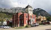 The Ouray County Courthouse
was constructed in Ouray in 1888 and is located on the National Register of Historic Places.
Mining operators in the San Juan mountain area
of Colorado formed the San Juan District Mining Association
(SJDMA) in 1903, as a direct result of a Western Federation of Miners
proposal to the Telluride Mining Association for the eight hour day
, which had been approved in a referendum by 72 percent of Colorado voters. The new association consolidated the power of thirty-six mining properties in San Miguel
, Ouray, and San Juan
counties. The SJDMA refused to consider any reduction in hours or increase in wages, helping to provoke a bitter strike.
of 2000, there were 3,742 people, 1,576 households, and 1,123 families residing in the county. The population density
was 7 people per square mile (3/km²). There were 2,146 housing units at an average density of 4 per square mile (2/km²). The racial makeup of the county was 96.34% White
, 0.08% Black
or African American
, 0.94% Native American
, 0.35% Asian
, 0.05% Pacific Islander
, 0.53% from other races
, and 1.71% from two or more races. 4.06% of the population were Hispanic
or Latino
of any race.
There were 1,576 households out of which 28.60% had children under the age of 18 living with them, 61.40% were married couples
living together, 6.50% had a female householder with no husband present, and 28.70% were non-families. 23.50% of all households were made up of individuals and 5.50% had someone living alone who was 65 years of age or older. The average household size was 2.36 and the average family size was 2.77.
In the county the population was spread out with 22.50% under the age of 18, 4.10% from 18 to 24, 27.20% from 25 to 44, 34.10% from 45 to 64, and 12.20% who were 65 years of age or older. The median age was 43 years. For every 100 females there were 102.10 males. For every 100 females age 18 and over, there were 100.80 males.
The median income for a household in the county was $42,019, and the median income for a family was $49,776. Males had a median income of $35,141 versus $26,176 for females. The per capita income
for the county was $24,335. About 6.00% of families and 7.20% of the population were below the poverty line, including 8.00% of those under age 18 and 2.90% of those age 65 or over.
Colona, Eldredge, and Dallas are located in the northern reaches of the county along U.S. Highway 550, though Eldredge and Dallas are located within the valleys of the San Juan Mountains while Colona is in the short stretch of the Uncompahgre Valley
within Ouray County. Portland is placed down valley of Ouray, though still south of Ridgway. Camp Bird and Thistledown are communities placed southwest of Ouray on Camp Bird Road. From north to south the communities are Colona, Eldredge, Dallas, Ridgway, Ouray, and then southwest along Camp Bird Road to Thistledown and Camp Bird. The historic towns of Sneffels and Ironton are located further west from Camp Bird and south of Ouray, respectively. Populations listed below are from the 2010 United States census data.
is located due north of Ridgway on the Ridgway Reservoir
and includes a marina and camping facilities as well as an extensive trail system. Within and surrounding the county are the Uncompahgre National Forest
, Mount Sneffels Wilderness
, and the Uncompahgre Wilderness
. Leading through the county is the Bear Creek National Recreation Trail. Well known for its view of the San Juan and Cimmaron mountains, scenic highways such as the Alpine Loop National Scenic Back Country Byway
and San Juan Skyway National Scenic Byway exist. The Great Parks Bicycle Route
and Western Express Bicycle Route
also go through Ouray County.
United States
The United States of America is a federal constitutional republic comprising fifty states and a federal district...
. The county population was 3,742 at U.S. Census 2000. As of 2010, U.S. Census data place the population at 4,436. The county seat
County seat
A county seat is an administrative center, or seat of government, for a county or civil parish. The term is primarily used in the United States....
is the City of Ouray
Ouray, Colorado
The historic City of Ouray is a Home Rule Municipality that is the county seat and the most populous city of Ouray County, Colorado, United States. The city population was 813 at the U.S. Census 2000 and 1,000 as of the U.S. Census 2010...
. Because of its rugged mountain geography, Ouray County is also known as the Switzerland of America.
Geography
According to the 2000 census, the county has a total area of 542.21 square miles (1,404.3 km²), of which 540.47 square miles (1,399.8 km²) (or 99.68%) is land and 1.74 square miles (4.5 km²) (or 0.32%) is water. The highest mountain in Ouray County is Mount SneffelsMount Sneffels
Mount Sneffels is a fourteen thousand foot mountain peak in the U.S. state of Colorado. It is located in the Mount Sneffels Wilderness of the northern San Juan Mountains, in Ouray County approximately 5 miles west of the town of Ouray. The summit of Mount Sneffels is the highest point in Ouray...
at 14,150 feet above sea level. Many high peaks of more than 13,300 feet also exist. Other prominent features in Ouray County include Log Hill Mesa
Log Hill Mesa
Log Hill Mesa is a mesa in Ouray County, Colorado, United States. Log Hill Mesa comprises part of the southern end of the Uncompahgre Plateau and faces south towards the Sneffels Range.-Recreation:...
and Pleasant Valley.
Adjacent counties
- Montrose CountyMontrose County, ColoradoMontrose County is the 17th most populous of the 64 counties of the State of Colorado of the United States. The county population was 41,276 at U.S. Census 2010. The county was named for its county seat, the City of Montrose...
, ColoradoColoradoColorado is a U.S. state that encompasses much of the Rocky Mountains as well as the northeastern portion of the Colorado Plateau and the western edge of the Great Plains...
- north - Gunnison CountyGunnison County, ColoradoGunnison County is the fifth most extensive of the 64 counties of the state of Colorado in the United States. The county population was 15,324 at the 2010 census. The county was named for John W. Gunnison, a United States Army officer and captain in the Army Topographical Engineers, who surveyed...
, ColoradoColoradoColorado is a U.S. state that encompasses much of the Rocky Mountains as well as the northeastern portion of the Colorado Plateau and the western edge of the Great Plains...
- northeast - Hinsdale CountyHinsdale County, ColoradoHinsdale County is the least densely populated of the 64 counties of the State of Colorado of the United States. The county population was 790 at U.S. Census 2000. The county seat and the only municipality in the county is the Town of Lake City. Hinsdale County is named for George A. Hinsdale, a...
, ColoradoColoradoColorado is a U.S. state that encompasses much of the Rocky Mountains as well as the northeastern portion of the Colorado Plateau and the western edge of the Great Plains...
- southeast - San Juan CountySan Juan County, ColoradoSan Juan County is the least populous of the 64 counties of the state of Colorado in the United States. The county name is the Spanish language name for “Saint John”, the name Spanish explorers gave to a river and the mountain range in the area. The county population was 558 at U.S. Census 2000...
, ColoradoColoradoColorado is a U.S. state that encompasses much of the Rocky Mountains as well as the northeastern portion of the Colorado Plateau and the western edge of the Great Plains...
- south - San Miguel CountySan Miguel County, ColoradoSan Miguel County is one of the 64 counties of the state of Colorado of the United States. The county is named for the San Miguel River. The county population was 6,594 at U.S. Census 2000...
, ColoradoColoradoColorado is a U.S. state that encompasses much of the Rocky Mountains as well as the northeastern portion of the Colorado Plateau and the western edge of the Great Plains...
- southwest
History
Ouray County was formed out of San Juan CountySan Juan County, Colorado
San Juan County is the least populous of the 64 counties of the state of Colorado in the United States. The county name is the Spanish language name for “Saint John”, the name Spanish explorers gave to a river and the mountain range in the area. The county population was 558 at U.S. Census 2000...
on 18 January 1877, the first county designated by the newly formed Colorado State Legislature. It was named for Chief Ouray
Chief Ouray
Ouray was a Native American chief of the Uncompahgre band of the Ute tribe, then located in western Colorado...
, a distinguished Ute Indian
Ute Tribe
The Ute are an American Indian people now living primarily in Utah and Colorado. There are three Ute tribal reservations: Uintah-Ouray in northeastern Utah ; Southern Ute in Colorado ; and Ute Mountain which primarily lies in Colorado, but extends to Utah and New Mexico . The name of the state of...
chief. Ouray
Ouray, Colorado
The historic City of Ouray is a Home Rule Municipality that is the county seat and the most populous city of Ouray County, Colorado, United States. The city population was 813 at the U.S. Census 2000 and 1,000 as of the U.S. Census 2010...
was designanted county seat on 8 March 1877. On 19 February 1881, Dolores County
Dolores County, Colorado
Dolores County is the seventh least populous of the 64 counties of the State of Colorado of the United States. The county population was 1,844 at U.S. Census 2000. The county seat is Dove Creek.- History :...
was formed out of Ouray County.
On 1883-02-27, Ouray County was split into San Miguel County
San Miguel County, Colorado
San Miguel County is one of the 64 counties of the state of Colorado of the United States. The county is named for the San Miguel River. The county population was 6,594 at U.S. Census 2000...
and what is currently Ouray County. The portion that became San Miguel County almost retained the name Ouray County when the Colorado General Assembly
Colorado General Assembly
The Colorado General Assembly is the state legislature of the State of Colorado.-Constitutional definition:The Colorado Constitution establishes a system of government based on the separation of powers doctrine with power divided among three "departments": executive, legislative and judicial...
initially renamed Ouray County as Uncompaghre County. Four days later on 1883-03-02, the General Assembly changed its mind and changed the name of Uncompaghre County back to Ouray County.
Ouray County Courthouse
The Ouray County Courthouse, constructed in 1888, is the seat of government of Ouray County, Colorado. It is located at the corner of 6th Avenue and 4th Street in Ouray, Colorado. This structure has been placed on the United States National Register of Historic Places.The courtroom was used in the...
was constructed in Ouray in 1888 and is located on the National Register of Historic Places.
Mining operators in the San Juan mountain area
San Juan Mountains
The San Juan Mountains are a high and rugged mountain range in the Rocky Mountains in southwestern Colorado. The area is highly mineralized and figured in the gold and silver mining industry of early Colorado. Major towns, all old mining camps, include Creede, Lake City, Silverton, Ouray, and...
of Colorado formed the San Juan District Mining Association
Mine Owners' Association
In the United States a Mine Owners' Association, also sometimes referred to as a Mine Operators' Association or a Mine Owners' Protective Association, is the combination of individual mining companies, or groups of mining companies, into an association, established for the purpose of promoting the...
(SJDMA) in 1903, as a direct result of a Western Federation of Miners
Western Federation of Miners
The Western Federation of Miners was a radical labor union that gained a reputation for militancy in the mines of the western United States and British Columbia. Its efforts to organize both hard rock miners and smelter workers brought it into sharp conflicts – and often pitched battles...
proposal to the Telluride Mining Association for the eight hour day
Eight-hour day
The eight-hour day movement or 40-hour week movement, also known as the short-time movement, had its origins in the Industrial Revolution in Britain, where industrial production in large factories transformed working life and imposed long hours and poor working conditions. With working conditions...
, which had been approved in a referendum by 72 percent of Colorado voters. The new association consolidated the power of thirty-six mining properties in San Miguel
San Miguel County, Colorado
San Miguel County is one of the 64 counties of the state of Colorado of the United States. The county is named for the San Miguel River. The county population was 6,594 at U.S. Census 2000...
, Ouray, and San Juan
San Juan County, Colorado
San Juan County is the least populous of the 64 counties of the state of Colorado in the United States. The county name is the Spanish language name for “Saint John”, the name Spanish explorers gave to a river and the mountain range in the area. The county population was 558 at U.S. Census 2000...
counties. The SJDMA refused to consider any reduction in hours or increase in wages, helping to provoke a bitter strike.
Demographics
As of the censusCensus
A census is the procedure of systematically acquiring and recording information about the members of a given population. It is a regularly occurring and official count of a particular population. The term is used mostly in connection with national population and housing censuses; other common...
of 2000, there were 3,742 people, 1,576 households, and 1,123 families residing in the county. The population density
Population density
Population density is a measurement of population per unit area or unit volume. It is frequently applied to living organisms, and particularly to humans...
was 7 people per square mile (3/km²). There were 2,146 housing units at an average density of 4 per square mile (2/km²). The racial makeup of the county was 96.34% White
Race (United States Census)
Race and ethnicity in the United States Census, as defined by the Federal Office of Management and Budget and the United States Census Bureau, are self-identification data items in which residents choose the race or races with which they most closely identify, and indicate whether or not they are...
, 0.08% Black
Race (United States Census)
Race and ethnicity in the United States Census, as defined by the Federal Office of Management and Budget and the United States Census Bureau, are self-identification data items in which residents choose the race or races with which they most closely identify, and indicate whether or not they are...
or African American
Race (United States Census)
Race and ethnicity in the United States Census, as defined by the Federal Office of Management and Budget and the United States Census Bureau, are self-identification data items in which residents choose the race or races with which they most closely identify, and indicate whether or not they are...
, 0.94% Native American
Race (United States Census)
Race and ethnicity in the United States Census, as defined by the Federal Office of Management and Budget and the United States Census Bureau, are self-identification data items in which residents choose the race or races with which they most closely identify, and indicate whether or not they are...
, 0.35% Asian
Race (United States Census)
Race and ethnicity in the United States Census, as defined by the Federal Office of Management and Budget and the United States Census Bureau, are self-identification data items in which residents choose the race or races with which they most closely identify, and indicate whether or not they are...
, 0.05% Pacific Islander
Race (United States Census)
Race and ethnicity in the United States Census, as defined by the Federal Office of Management and Budget and the United States Census Bureau, are self-identification data items in which residents choose the race or races with which they most closely identify, and indicate whether or not they are...
, 0.53% from other races
Race (United States Census)
Race and ethnicity in the United States Census, as defined by the Federal Office of Management and Budget and the United States Census Bureau, are self-identification data items in which residents choose the race or races with which they most closely identify, and indicate whether or not they are...
, and 1.71% from two or more races. 4.06% of the population were Hispanic
Race (United States Census)
Race and ethnicity in the United States Census, as defined by the Federal Office of Management and Budget and the United States Census Bureau, are self-identification data items in which residents choose the race or races with which they most closely identify, and indicate whether or not they are...
or Latino
Race (United States Census)
Race and ethnicity in the United States Census, as defined by the Federal Office of Management and Budget and the United States Census Bureau, are self-identification data items in which residents choose the race or races with which they most closely identify, and indicate whether or not they are...
of any race.
There were 1,576 households out of which 28.60% had children under the age of 18 living with them, 61.40% were married couples
Marriage
Marriage is a social union or legal contract between people that creates kinship. It is an institution in which interpersonal relationships, usually intimate and sexual, are acknowledged in a variety of ways, depending on the culture or subculture in which it is found...
living together, 6.50% had a female householder with no husband present, and 28.70% were non-families. 23.50% of all households were made up of individuals and 5.50% had someone living alone who was 65 years of age or older. The average household size was 2.36 and the average family size was 2.77.
In the county the population was spread out with 22.50% under the age of 18, 4.10% from 18 to 24, 27.20% from 25 to 44, 34.10% from 45 to 64, and 12.20% who were 65 years of age or older. The median age was 43 years. For every 100 females there were 102.10 males. For every 100 females age 18 and over, there were 100.80 males.
The median income for a household in the county was $42,019, and the median income for a family was $49,776. Males had a median income of $35,141 versus $26,176 for females. The per capita income
Per capita income
Per capita income or income per person is a measure of mean income within an economic aggregate, such as a country or city. It is calculated by taking a measure of all sources of income in the aggregate and dividing it by the total population...
for the county was $24,335. About 6.00% of families and 7.20% of the population were below the poverty line, including 8.00% of those under age 18 and 2.90% of those age 65 or over.
Cities and towns
Ouray County has two home rule municipalities, three census-designated places, and four unincorporated communities. The home rule municipalities are the city of Ouray and town of Ridgway, also the most populous settlements in the county. Loghill Village is the next largest development and is a residential, relatively affluent, community in comparison to the rest of the county. Along with Loghill, Portland and Colona serve as census-designated places within Ouray County. The unincorporated communities within the county are Camp Bird, Dallas, Thistledown, and Eldredge. All the communities with the exception of Ridgway and Ouray serve as primarily residential communities, though Loghill Village maintains a small tourism sector.Colona, Eldredge, and Dallas are located in the northern reaches of the county along U.S. Highway 550, though Eldredge and Dallas are located within the valleys of the San Juan Mountains while Colona is in the short stretch of the Uncompahgre Valley
Uncompahgre Valley
The Uncompahgre Valley is an agricultural valley of the Uncompahgre River around the town of Montrose in the western part of the U.S. state of Colorado...
within Ouray County. Portland is placed down valley of Ouray, though still south of Ridgway. Camp Bird and Thistledown are communities placed southwest of Ouray on Camp Bird Road. From north to south the communities are Colona, Eldredge, Dallas, Ridgway, Ouray, and then southwest along Camp Bird Road to Thistledown and Camp Bird. The historic towns of Sneffels and Ironton are located further west from Camp Bird and south of Ouray, respectively. Populations listed below are from the 2010 United States census data.
Incorporated cities and towns
|
Census-designated places
|
Unincorporated communities
|
Historic towns
- DallasDallas, ColoradoDallas was a town in Ouray County, Colorado, United States. It lay about 3 miles north of the present town of Ridgway at the confluence of Dallas Creek and the Uncompahgre River...
- IrontonIronton, Colorado-History:Ironton was a town in Ouray County, Colorado, United States. It lay about south of the present town of Ouray."Ironton was a major transportation junction between Red Mountain and Ouray in addition to having some of its own mines. Ironton had a peak population of over 1000 and had two...
- SneffelsSneffels, ColoradoSneffels was a town in Ouray County, Colorado, United States named after Mount Sneffels. It lay west of Camp Bird.-Mining era:Sneffels was founded in 1875 and named after the mountain it was built on. The town peaked at 2000 people and grew largely between the mid 1880's until 1891.-External links:*...
Recreation
Ouray County, named Switzerland of America, is home to many parks and hiking trails. The Ridgway State ParkRidgway State Park
Ridgway State Park is a state park located in Ouray County, Colorado. It is the westernmost state park in Colorado. The park is 21 miles southeast of Montrose, 14 miles northeast of Ouray, it is also 4 miles north of the town of Ridgway and 312 miles southwest of Denver. The current wildlife...
is located due north of Ridgway on the Ridgway Reservoir
Ridgway Reservoir
Ridgway Reservoir is a lake impounded by Ridgway Dam on the Uncompahgre River south of the town of Ridgway in Ouray County, Colorado in the western United States....
and includes a marina and camping facilities as well as an extensive trail system. Within and surrounding the county are the Uncompahgre National Forest
Uncompahgre National Forest
Uncompahgre National Forest is a U.S. National Forest covering 955,229 acres in parts of Montrose, Mesa, San Miguel, Ouray, Gunnison, San Juan, and Delta Counties in western Colorado...
, Mount Sneffels Wilderness
Mount Sneffels Wilderness
The Mount Sneffels Wilderness is a wilderness area in southwest Colorado managed by the Uncompahgre National Forest. It is about 5 miles west of the town of Ouray. The area is named for Mt. Sneffels a prominent fourteener in the San Juan Mountains...
, and the Uncompahgre Wilderness
Uncompahgre Wilderness
The Uncompahgre Wilderness is a U.S. Wilderness Area in southwest Colorado comprising 102,721 acres...
. Leading through the county is the Bear Creek National Recreation Trail. Well known for its view of the San Juan and Cimmaron mountains, scenic highways such as the Alpine Loop National Scenic Back Country Byway
Alpine Loop National Scenic Back Country Byway
The Alpine Loop National Back Country Byway is located northeast of Silverton, Colorado in San Juan and Hinsdale Counties. The route is circular, running from the ghost town of Animas Forks to Lake City and return...
and San Juan Skyway National Scenic Byway exist. The Great Parks Bicycle Route
Great Parks Bicycle Route
The Great Parks Bicycle Route is a 2455 mile bicycle touring route that extends from Jasper, Alberta, to Durango, Colorado. The route passes through Jasper National Park, Banff National Park, Kootenay National Park, and Waterton Lakes National Park in Canada...
and Western Express Bicycle Route
Western Express Bicycle Route
The Western Express Bicycle Route is a 1579 mile bicycle touring route that connects San Francisco, California, to the TransAmerica Bicycle Trail in Pueblo, Colorado, traveling through California, Nevada, Utah, and Colorado. The route is mapped by the Adventure Cycling Association...
also go through Ouray County.
See also
- Communities of Ouray CountyCommunities of Ouray County-Communities:* Cimarron Mesa - A Log Hill Mesa residential community on the northern slopes of the mesa.* Dallas Meadows - A community on a relatively flat region of the valley just north of Eagle Hill and bordering the Uncompahgre River....
- National Register of Historic Places listings in Ouray County, Colorado
- Colorado countiesColorado countiesThe U.S state of Colorado is divided into 64 counties. Counties are important units of government in Colorado since the state has no secondary civil subdivisions, such as townships...