
Custer County, Colorado
Encyclopedia
Custer County is the tenth least populous of the 64 counties
of the State of Colorado of the United States
. The county population was 3,503 at U.S. Census 2000. The county seat
is Westcliffe
.
. Originally set in Ula, the county seat moved to Rosita
in 1878, and to Silver Cliff
in 1886 before settling in Westcliffe in 1928. It was named in honor of Lt. Colonel George Armstrong Custer
, who had died the previous year.
The county was the site of a silver
rush during the 1870s. Thousands of men poured into the county during this time in the hunt for silver. Some of the notable mines include the Geyser Mine (on the north edge of the town of Silver Cliff), the Bassick Mine (near the ghost town of Querida
) and the Bull Domingo (north of Silver Cliff).
During the late 19th century a railroad line was connected through the Grape Creek Canyon but was permanently closed after a few disastrous floods. The old railhouse has been turned into a historical landmark in the town of Westcliffe.
After the mines were exhausted, the population dropped considerably and was replaced by cattle ranchers. An extensive system of irrigation ditches was built throughout the valley. Ranching in the Wet Mountain Valley continues to this day.
 According to the 2000 census, the county has a total area of 739.9 square miles (1,916.3 km²), of which 738.89 square miles (1,913.7 km²) (or 99.86%) is land and 1.02 square miles (2.6 km²) (or 0.14%) is water.
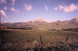
The county is very rugged and would be virtually inaccessible without roads. The lowest point of the county is around 6000 feet (1,828.8 m) in elevation, but most of the county is rugged and mountainous. The county seat of Westcliffe
is about 7800 feet (2,377.4 m) and along with nearby town Silver Cliff
lies in the Wet Mountain Valley
which sits at the base of the Sangre de Cristo Mountains. The peaks of the Sangre de Cristo Mountains to the west reach heights in excess of 14000 feet (4,267.2 m) with Crestone Peak
being the highest at 14294 feet (4,356.8 m) and 7th highest fourteener
in Colorado
.
A large percentage of the county is National Forest land in the Sangre de Cristo Mountains on the west side and in the Wet Mountains
on the east. The only lake of size is the Deweese Reservoir in the north end of the Wet Mountain Valley.
of 2000, there were 3,503 people, 1,480 households, and 1,077 families residing in the county. The population density
was 5 people per square mile (2/km²). There were 2,989 housing units at an average density of 4 per square mile (2/km²). The racial makeup of the county was 95.89% White
, 0.37% Black
or African American
, 1.11% Native American
, 0.29% Asian
, 0.71% from other races
, and 1.63% from two or more races. 2.51% of the population were Hispanic
or Latino
of any race.
There were 1,480 households out of which 25.50% had children under the age of 18 living with them, 64.60% were married couples
living together, 5.40% had a female householder with no husband present, and 27.20% were non-families. 23.80% of all households were made up of individuals and 7.90% had someone living alone who was 65 years of age or older. The average household size was 2.36 and the average family size was 2.77.
In the county the population was spread out with 22.50% under the age of 18, 4.50% from 18 to 24, 23.30% from 25 to 44, 35.00% from 45 to 64, and 14.80% who were 65 years of age or older. The median age was 45 years. For every 100 females there were 104.30 males. For every 100 females age 18 and over, there were 102.00 males.
The median income for a household in the county was $34,731, and the median income for a family was $41,198. Males had a median income of $32,460 versus $20,868 for females. The per capita income
for the county was $19,817. About 9.80% of families and 13.30% of the population were below the poverty line, including 20.10% of those under age 18 and 12.60% of those age 65 or over.
who are elected to 4-year terms with a term limit of two. In 2008, the county was represented by:
-District 1: Carole Custer (Republican), serving from 2006–2010
-District 2: Dick Downey (Republican), serving from 2000–2008
-District 3: Kit Shy (Republican), serving from 2004-2008 which chance for reelection in 2008
However, as of March 2009, Dick Downey and Kit Shy were replaced by Jim Austin and Lynn Attebery, Chairman.
There are several other public offices including Coroner, Sheriff, County Clerk and others.
, but the primary election
between members of the Republican Party
in August. During the 2004 presidential election
, well over 60% of Custer County voters voted for the Republican candidates including George W. Bush
and Pete Coors
.
Despite the surface appearance of a homogeneous political culture, there is considerable dispute among residents over planning. One segment of residents (which includes ranchers) would like to see the County preserved in its present state as a mountain paradise with its rural ranching culture, with strict limitation on development. Proponents are sometimes seen as "anti-growth" and "anti-property rights." Another segment of the population would like to see less government and less restrictions on growth and development for the growth of business and the economy. Proponents are seen as "anti-environment" or "anti-agriculture."
Colorado counties
The U.S state of Colorado is divided into 64 counties. Counties are important units of government in Colorado since the state has no secondary civil subdivisions, such as townships...
of the State of Colorado of the United States
United States
The United States of America is a federal constitutional republic comprising fifty states and a federal district...
. The county population was 3,503 at U.S. Census 2000. The county seat
County seat
A county seat is an administrative center, or seat of government, for a county or civil parish. The term is primarily used in the United States....
is Westcliffe
Westcliffe, Colorado
-Nonprofit Cultural Groups:* * * * * -Media:* * * -External links:***...
.
History
Custer County was created by the Colorado legislature on March 9, 1877, out of the southern half of Fremont CountyFremont County, Colorado
Fremont County is the thirteenth most populous of the 64 counties of the state of Colorado of the United States. The county is named for explorer and presidential candidate John C. Frémont. The county population was 46,824 at the 2010 census. The county seat is Cañon City. The Cañon City...
. Originally set in Ula, the county seat moved to Rosita
Rosita, Colorado
Rosita was a silver mining town — now a ghost town — in Custer County, Colorado, United States. Rosita is Spanish for little rose. Although the old town has almost entirely disappeared , the surrounding area has been largely developed into semi-rural home sites.The town was used in the filming of...
in 1878, and to Silver Cliff
Silver Cliff, Colorado
Silver Cliff is a Statutory Town that is the most populous town in Custer County, Colorado, United States. The population was 512 at the 2000 census.-History:...
in 1886 before settling in Westcliffe in 1928. It was named in honor of Lt. Colonel George Armstrong Custer
George Armstrong Custer
George Armstrong Custer was a United States Army officer and cavalry commander in the American Civil War and the Indian Wars. Raised in Michigan and Ohio, Custer was admitted to West Point in 1858, where he graduated last in his class...
, who had died the previous year.
The county was the site of a silver
Silver
Silver is a metallic chemical element with the chemical symbol Ag and atomic number 47. A soft, white, lustrous transition metal, it has the highest electrical conductivity of any element and the highest thermal conductivity of any metal...
rush during the 1870s. Thousands of men poured into the county during this time in the hunt for silver. Some of the notable mines include the Geyser Mine (on the north edge of the town of Silver Cliff), the Bassick Mine (near the ghost town of Querida
Querida, Colorado
Querida is a ghost town in Custer County, Colorado, United States. The town was built to serve the surrounding silver mines, the most important of which was the Bassick mine. Querida is Spanish for "beloved."-Geography:...
) and the Bull Domingo (north of Silver Cliff).
During the late 19th century a railroad line was connected through the Grape Creek Canyon but was permanently closed after a few disastrous floods. The old railhouse has been turned into a historical landmark in the town of Westcliffe.
After the mines were exhausted, the population dropped considerably and was replaced by cattle ranchers. An extensive system of irrigation ditches was built throughout the valley. Ranching in the Wet Mountain Valley continues to this day.
Geography
The county is very rugged and would be virtually inaccessible without roads. The lowest point of the county is around 6000 feet (1,828.8 m) in elevation, but most of the county is rugged and mountainous. The county seat of Westcliffe
Westcliffe, Colorado
-Nonprofit Cultural Groups:* * * * * -Media:* * * -External links:***...
is about 7800 feet (2,377.4 m) and along with nearby town Silver Cliff
Silver Cliff, Colorado
Silver Cliff is a Statutory Town that is the most populous town in Custer County, Colorado, United States. The population was 512 at the 2000 census.-History:...
lies in the Wet Mountain Valley
Wet Mountain Valley
The Wet Mountain Valley is a high elevation mountain valley located in Custer County in south-central Colorado. The towns in the valley are Westcliffe and Silver Cliff, which are at an elevation of just under 8,000 feet...
which sits at the base of the Sangre de Cristo Mountains. The peaks of the Sangre de Cristo Mountains to the west reach heights in excess of 14000 feet (4,267.2 m) with Crestone Peak
Crestone Peak
Crestone Peak is the seventh highest peak in the U.S. state of Colorado. It is the second highest peak in the Sangre de Cristo Range after Blanca Peak. It rises in the Sangre de Cristo Wilderness above the east side of the San Luis Valley along the boundary between Saguache and Custer counties,...
being the highest at 14294 feet (4,356.8 m) and 7th highest fourteener
Fourteener
In mountaineering terminology in the United States, a fourteener is a mountain that exceeds 14,000 feet above mean sea level. There are 547 fourteeners in the world. The importance of fourteeners is greatest in Colorado, which has the majority of such peaks in North America...
in Colorado
Colorado
Colorado is a U.S. state that encompasses much of the Rocky Mountains as well as the northeastern portion of the Colorado Plateau and the western edge of the Great Plains...
.
A large percentage of the county is National Forest land in the Sangre de Cristo Mountains on the west side and in the Wet Mountains
Wet Mountains
The Wet Mountains are a small range of mountains in southern Colorado named for the amount of snow they receive in the winter. There are three variant names of this range: Cuerno Verde, Greenhorn Mountains, and Sierra Mojadas...
on the east. The only lake of size is the Deweese Reservoir in the north end of the Wet Mountain Valley.
Adjacent counties
- Fremont CountyFremont County, ColoradoFremont County is the thirteenth most populous of the 64 counties of the state of Colorado of the United States. The county is named for explorer and presidential candidate John C. Frémont. The county population was 46,824 at the 2010 census. The county seat is Cañon City. The Cañon City...
, ColoradoColoradoColorado is a U.S. state that encompasses much of the Rocky Mountains as well as the northeastern portion of the Colorado Plateau and the western edge of the Great Plains...
- north - Pueblo CountyPueblo County, ColoradoPueblo County is the tenth most populous of the 64 counties of the state of Colorado of the United States. The county was named for the historic city of Pueblo which took its name from the Spanish language word meaning "town" or "village". The United States Census Bureau estimates that the...
, ColoradoColoradoColorado is a U.S. state that encompasses much of the Rocky Mountains as well as the northeastern portion of the Colorado Plateau and the western edge of the Great Plains...
- east - Huerfano CountyHuerfano County, ColoradoHuerfano County is one of the 64 counties of the State of Colorado of the United States. The county was named for the Huerfano Butte, a local landmark. The county population was 7,862 at U.S. Census 2000...
, ColoradoColoradoColorado is a U.S. state that encompasses much of the Rocky Mountains as well as the northeastern portion of the Colorado Plateau and the western edge of the Great Plains...
- southeast - Saguache CountySaguache County, ColoradoSaguache County is the seventh most extensive of the 64 counties of the state of Colorado of the United States. The county name comes from a Ute language word meaning “blue earth” or “water at blue earth”. The county population was 5,917 at U.S. Census 2000...
, ColoradoColoradoColorado is a U.S. state that encompasses much of the Rocky Mountains as well as the northeastern portion of the Colorado Plateau and the western edge of the Great Plains...
- west
Demographics
As of the censusCensus
A census is the procedure of systematically acquiring and recording information about the members of a given population. It is a regularly occurring and official count of a particular population. The term is used mostly in connection with national population and housing censuses; other common...
of 2000, there were 3,503 people, 1,480 households, and 1,077 families residing in the county. The population density
Population density
Population density is a measurement of population per unit area or unit volume. It is frequently applied to living organisms, and particularly to humans...
was 5 people per square mile (2/km²). There were 2,989 housing units at an average density of 4 per square mile (2/km²). The racial makeup of the county was 95.89% White
Race (United States Census)
Race and ethnicity in the United States Census, as defined by the Federal Office of Management and Budget and the United States Census Bureau, are self-identification data items in which residents choose the race or races with which they most closely identify, and indicate whether or not they are...
, 0.37% Black
Race (United States Census)
Race and ethnicity in the United States Census, as defined by the Federal Office of Management and Budget and the United States Census Bureau, are self-identification data items in which residents choose the race or races with which they most closely identify, and indicate whether or not they are...
or African American
Race (United States Census)
Race and ethnicity in the United States Census, as defined by the Federal Office of Management and Budget and the United States Census Bureau, are self-identification data items in which residents choose the race or races with which they most closely identify, and indicate whether or not they are...
, 1.11% Native American
Race (United States Census)
Race and ethnicity in the United States Census, as defined by the Federal Office of Management and Budget and the United States Census Bureau, are self-identification data items in which residents choose the race or races with which they most closely identify, and indicate whether or not they are...
, 0.29% Asian
Race (United States Census)
Race and ethnicity in the United States Census, as defined by the Federal Office of Management and Budget and the United States Census Bureau, are self-identification data items in which residents choose the race or races with which they most closely identify, and indicate whether or not they are...
, 0.71% from other races
Race (United States Census)
Race and ethnicity in the United States Census, as defined by the Federal Office of Management and Budget and the United States Census Bureau, are self-identification data items in which residents choose the race or races with which they most closely identify, and indicate whether or not they are...
, and 1.63% from two or more races. 2.51% of the population were Hispanic
Race (United States Census)
Race and ethnicity in the United States Census, as defined by the Federal Office of Management and Budget and the United States Census Bureau, are self-identification data items in which residents choose the race or races with which they most closely identify, and indicate whether or not they are...
or Latino
Race (United States Census)
Race and ethnicity in the United States Census, as defined by the Federal Office of Management and Budget and the United States Census Bureau, are self-identification data items in which residents choose the race or races with which they most closely identify, and indicate whether or not they are...
of any race.
There were 1,480 households out of which 25.50% had children under the age of 18 living with them, 64.60% were married couples
Marriage
Marriage is a social union or legal contract between people that creates kinship. It is an institution in which interpersonal relationships, usually intimate and sexual, are acknowledged in a variety of ways, depending on the culture or subculture in which it is found...
living together, 5.40% had a female householder with no husband present, and 27.20% were non-families. 23.80% of all households were made up of individuals and 7.90% had someone living alone who was 65 years of age or older. The average household size was 2.36 and the average family size was 2.77.
In the county the population was spread out with 22.50% under the age of 18, 4.50% from 18 to 24, 23.30% from 25 to 44, 35.00% from 45 to 64, and 14.80% who were 65 years of age or older. The median age was 45 years. For every 100 females there were 104.30 males. For every 100 females age 18 and over, there were 102.00 males.
The median income for a household in the county was $34,731, and the median income for a family was $41,198. Males had a median income of $32,460 versus $20,868 for females. The per capita income
Per capita income
Per capita income or income per person is a measure of mean income within an economic aggregate, such as a country or city. It is calculated by taking a measure of all sources of income in the aggregate and dividing it by the total population...
for the county was $19,817. About 9.80% of families and 13.30% of the population were below the poverty line, including 20.10% of those under age 18 and 12.60% of those age 65 or over.
Government
The county is governed by three County CommissionersCounty commission
A county commission is a group of elected officials charged with administering the county government in local government in some states of the United States. County commissions are usually made up of three or more individuals...
who are elected to 4-year terms with a term limit of two. In 2008, the county was represented by:
-District 1: Carole Custer (Republican), serving from 2006–2010
-District 2: Dick Downey (Republican), serving from 2000–2008
-District 3: Kit Shy (Republican), serving from 2004-2008 which chance for reelection in 2008
However, as of March 2009, Dick Downey and Kit Shy were replaced by Jim Austin and Lynn Attebery, Chairman.
There are several other public offices including Coroner, Sheriff, County Clerk and others.
Politics
Custer County is overall very conservative and heavily Republican. The most important election is not the general electionGeneral election
In a parliamentary political system, a general election is an election in which all or most members of a given political body are chosen. The term is usually used to refer to elections held for a nation's primary legislative body, as distinguished from by-elections and local elections.The term...
, but the primary election
Primary election
A primary election is an election in which party members or voters select candidates for a subsequent election. Primary elections are one means by which a political party nominates candidates for the next general election....
between members of the Republican Party
Republican Party (United States)
The Republican Party is one of the two major contemporary political parties in the United States, along with the Democratic Party. Founded by anti-slavery expansion activists in 1854, it is often called the GOP . The party's platform generally reflects American conservatism in the U.S...
in August. During the 2004 presidential election
United States presidential election, 2004
The United States presidential election of 2004 was the United States' 55th quadrennial presidential election. It was held on Tuesday, November 2, 2004. Republican Party candidate and incumbent President George W. Bush defeated Democratic Party candidate John Kerry, the then-junior U.S. Senator...
, well over 60% of Custer County voters voted for the Republican candidates including George W. Bush
George W. Bush
George Walker Bush is an American politician who served as the 43rd President of the United States, from 2001 to 2009. Before that, he was the 46th Governor of Texas, having served from 1995 to 2000....
and Pete Coors
Pete Coors
Peter Hanson Coors is a U.S. businessman and entrepreneur. He currently is the Chairman of the Molson Coors Brewing Company and Chairman of MillerCoors, a joint operating venture, announced October 9, 2007 and completed June 30, 2008. Molson Coors headquarters are located in Colorado and...
.
Despite the surface appearance of a homogeneous political culture, there is considerable dispute among residents over planning. One segment of residents (which includes ranchers) would like to see the County preserved in its present state as a mountain paradise with its rural ranching culture, with strict limitation on development. Proponents are sometimes seen as "anti-growth" and "anti-property rights." Another segment of the population would like to see less government and less restrictions on growth and development for the growth of business and the economy. Proponents are seen as "anti-environment" or "anti-agriculture."
Cities and towns
- Cold Spring
- ColfaxColfax, ColoradoColfax was a short-lived communal farming community — now a ghost town — in Custer County, Colorado, United States. It was named after Vice President Schuyler Colfax.-History:...
- Fairview
- Greenwood
- McKenzie Junction
- QueridaQuerida, ColoradoQuerida is a ghost town in Custer County, Colorado, United States. The town was built to serve the surrounding silver mines, the most important of which was the Bassick mine. Querida is Spanish for "beloved."-Geography:...
- RositaRosita, ColoradoRosita was a silver mining town — now a ghost town — in Custer County, Colorado, United States. Rosita is Spanish for little rose. Although the old town has almost entirely disappeared , the surrounding area has been largely developed into semi-rural home sites.The town was used in the filming of...
- San Isabel
- Silver CliffSilver Cliff, ColoradoSilver Cliff is a Statutory Town that is the most populous town in Custer County, Colorado, United States. The population was 512 at the 2000 census.-History:...
- Tanglewood Acres
- Ula (historical)
- WestcliffeWestcliffe, Colorado-Nonprofit Cultural Groups:* * * * * -Media:* * * -External links:***...
- WetmoreWetmore, ColoradoWetmore is an unincorporated town and a U.S. Post Office located in Custer County, Colorado, United States. The Wetmore Post Office has the ZIP Code 81253....
Transcontinental bicycle routes
- TransAmerica Trail Bicycle Route
- Western Express Bicycle RouteWestern Express Bicycle RouteThe Western Express Bicycle Route is a 1579 mile bicycle touring route that connects San Francisco, California, to the TransAmerica Bicycle Trail in Pueblo, Colorado, traveling through California, Nevada, Utah, and Colorado. The route is mapped by the Adventure Cycling Association...
See also
- Colorado census statistical areas
- Colorado countiesColorado countiesThe U.S state of Colorado is divided into 64 counties. Counties are important units of government in Colorado since the state has no secondary civil subdivisions, such as townships...
- Colorado municipalitiesColorado municipalitiesThe U.S. state of Colorado currently has 271 active incorporated municipalities, including 196 towns, 73 cities, and two consolidated city and county governments.-Municipal government:...
- National Register of Historic Places listings in Custer County, Colorado