

Boulder County, Colorado
Encyclopedia
Boulder County is the sixth most populous of the 64 counties
of the state of Colorado
of the United States
. The county seat
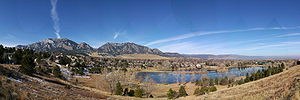
is Boulder
. The most populous municipality
in the county and the county seat
is the City of Boulder
. Boulder County is coextensive with the Boulder Metropolitan Statistical Area, an Office of Management and Budget-designated metropolitan statistical area also used for statistical purposes by the Census Bureau.
The United States Census Bureau
estimated that the county population was 280,440 in 2005 and 282,304 in 2006. This was a loss of 3.72% between 2005 and 2000, but a gain of 3.95% since 2000 excluding the area transferred to the City and County of Broomfield
. Boulder Metropolitan Statistical Area is the 161st most populous metropolitan statistical area in the United States
.
The Boulder MSA together with the Denver-Aurora MSA, and the Greeley MSA comprise the Denver-Aurora-Boulder Combined Statistical Area
.
and Boulder Creek
, so named because of the abundance of boulders in the area. Boulder County retains essentially the same borders as in 1861, although a 27.5 square miles (71.2 km²) of its southeastern corner and its approximate population of 40,000 became part of the City and County of Broomfield
in 2001.
 According to the 2000 census, the county has a total area of 751.37 square miles (1,946 km²), of which 742.46 square miles (1,923 km²) (or 98.81%) is land and 8.91 square miles (23.1 km²) (or 1.19%) is water.
of 2000, there were 271,651 people, 114,680 households, and 68,808 families residing in the county. The population density
was 392 people per square mile (151/km²). There were 119,900 housing units at an average density of 162 per square mile (62/km²). The racial makeup of the county was 88.54% White
, 0.88% Black
or African American
, 0.61% Native American
, 3.06% Asian
, 0.06% Pacific Islander
, 4.67% from other races
, and 2.18% from two or more races. 10.46% of the population were Hispanic
or Latino
of any race.
There were 114,680 households out of which 30.70% had children under the age of 18 living with them, 48.90% were married couples
living together, 7.70% had a female householder with no husband present, and 40.00% were non-families. 26.30% of all households were made up of individuals and 5.50% had someone living alone who was 65 years of age or older. The average household size was 2.47 and the average family size was 3.03.
In the county the population was spread out with 22.90% under the age of 18, 13.40% from 18 to 24, 33.60% from 25 to 44, 22.30% from 45 to 64, and 7.80% who were 65 years of age or older. The median age was 33 years. For every 100 females there were 102.20 males. For every 100 females age 18 and over, there were 101.70 males.
The median income for a household in the county was $55,861, and the median income for a family was $70,572. Males had a median income of $48,047 versus $32,207 for females. The per capita income
for the county was $28,976. About 4.60% of families and 9.50% of the population were below the poverty line, including 7.60% of those under age 18 and 5.90% of those age 65 or over.
The Board of County Commissioners are full-time public servants and as such approve the budget for the entire County government. The Board also oversees the management of 10 County departments and the daily operations of the county, work that is done by a county manager or a chief administrative officer in some counties.
In addition to the commissioners Boulder County has seven other county-wide elected officials including the District Attorney, who represents the 20th Judicial District.
* Cindy Domenico was appointed in July 2007 to fill Tom Mayer's seat after he died in June 2007. In 2008, voters elected Domenico to complete the remainder of the term which runs through 2010.
** Jerry Roberts was appointed in July 2007 to replace Cindy Domenico who was elected to the post of Boulder County Commissioner. In 2008, voters elected Roberts to complete the remainder of the term which runs through 2010.
, the state trial court
of general jurisdiction
, serves and is coextensive with Boulder County. As of 2009 the 20th Judicial Circuit has eight District Court judges. The Boulder County Court, the state trial court of limited jurisdiction
, consists of five judges and six magistrate
s.
Boulder County has two combined courthouse
s:
is located in Boulder County, Larimer County
, and Grand County
. Longs Peak
, the park's highest summit at 4345 meters (14,255 ft) elevation, is located in Boulder County.
Colorado counties
The U.S state of Colorado is divided into 64 counties. Counties are important units of government in Colorado since the state has no secondary civil subdivisions, such as townships...
of the state of Colorado
Colorado
Colorado is a U.S. state that encompasses much of the Rocky Mountains as well as the northeastern portion of the Colorado Plateau and the western edge of the Great Plains...
of the United States
United States
The United States of America is a federal constitutional republic comprising fifty states and a federal district...
. The county seat
County seat
A county seat is an administrative center, or seat of government, for a county or civil parish. The term is primarily used in the United States....
is Boulder
Boulder, Colorado
Boulder is the county seat and most populous city of Boulder County and the 11th most populous city in the U.S. state of Colorado. Boulder is located at the base of the foothills of the Rocky Mountains at an elevation of...
. The most populous municipality
Colorado municipalities
The U.S. state of Colorado currently has 271 active incorporated municipalities, including 196 towns, 73 cities, and two consolidated city and county governments.-Municipal government:...
in the county and the county seat
County seat
A county seat is an administrative center, or seat of government, for a county or civil parish. The term is primarily used in the United States....
is the City of Boulder
Boulder, Colorado
Boulder is the county seat and most populous city of Boulder County and the 11th most populous city in the U.S. state of Colorado. Boulder is located at the base of the foothills of the Rocky Mountains at an elevation of...
. Boulder County is coextensive with the Boulder Metropolitan Statistical Area, an Office of Management and Budget-designated metropolitan statistical area also used for statistical purposes by the Census Bureau.
The United States Census Bureau
United States Census Bureau
The United States Census Bureau is the government agency that is responsible for the United States Census. It also gathers other national demographic and economic data...
estimated that the county population was 280,440 in 2005 and 282,304 in 2006. This was a loss of 3.72% between 2005 and 2000, but a gain of 3.95% since 2000 excluding the area transferred to the City and County of Broomfield
Broomfield, Colorado
The City and County of Broomfield is a prominent suburb and tier of the Denver metropolitan area in the State of Colorado of the United States. Broomfield has a consolidated city and county government which operates under Article XX, Sections 10-13 of the Constitution of the State of Colorado. The...
. Boulder Metropolitan Statistical Area is the 161st most populous metropolitan statistical area in the United States
United States
The United States of America is a federal constitutional republic comprising fifty states and a federal district...
.
The Boulder MSA together with the Denver-Aurora MSA, and the Greeley MSA comprise the Denver-Aurora-Boulder Combined Statistical Area
Denver-Aurora-Boulder Combined Statistical Area
thumb|300px|Map of the 12-county Denver-Aurora-Boulder Combined Statistical AreaThe Denver-Aurora-Boulder, CO Combined Statistical Area is a United States Census Bureau defined Combined Statistical Area located in the Denver region of the state of Colorado...
.
History
Boulder County was one of the original 17 counties created by the Territory of Colorado on November 1, 1861. The county was named for Boulder CityBoulder, Colorado
Boulder is the county seat and most populous city of Boulder County and the 11th most populous city in the U.S. state of Colorado. Boulder is located at the base of the foothills of the Rocky Mountains at an elevation of...
and Boulder Creek
Boulder Creek (Colorado)
Boulder Creek is a creek draining the Rocky Mountains to the west of Boulder, Colorado, as well as the city itself and surrounding plains.- Route :...
, so named because of the abundance of boulders in the area. Boulder County retains essentially the same borders as in 1861, although a 27.5 square miles (71.2 km²) of its southeastern corner and its approximate population of 40,000 became part of the City and County of Broomfield
Broomfield, Colorado
The City and County of Broomfield is a prominent suburb and tier of the Denver metropolitan area in the State of Colorado of the United States. Broomfield has a consolidated city and county government which operates under Article XX, Sections 10-13 of the Constitution of the State of Colorado. The...
in 2001.
Geography
Adjacent counties
- Larimer CountyLarimer County, ColoradoLarimer County is the seventh most populous and the ninth most extensive of the 64 counties of the State of Colorado of the United States. The county is located at the northern end of the Front Range, at the edge of the Colorado Eastern Plains along the border with Wyoming...
, ColoradoColoradoColorado is a U.S. state that encompasses much of the Rocky Mountains as well as the northeastern portion of the Colorado Plateau and the western edge of the Great Plains...
- north - Weld CountyWeld County, ColoradoAs of the census of 2000, there were 180,936 people, 63,247 households, and 45,221 families residing in the county. The population density was 45 people per square mile . There were 66,194 housing units at an average density of 17 per square mile...
, ColoradoColoradoColorado is a U.S. state that encompasses much of the Rocky Mountains as well as the northeastern portion of the Colorado Plateau and the western edge of the Great Plains...
- east - City and County of Broomfield, ColoradoBroomfield, ColoradoThe City and County of Broomfield is a prominent suburb and tier of the Denver metropolitan area in the State of Colorado of the United States. Broomfield has a consolidated city and county government which operates under Article XX, Sections 10-13 of the Constitution of the State of Colorado. The...
- southeast - Jefferson CountyJefferson County, ColoradoJefferson County , whose slogan is the "Gateway to the Rocky Mountains", is the fourth most populous of the 64 counties of the State of Colorado of the United States. Located along the Front Range of the Rocky Mountains, Jefferson County is adjacent to the west side of the state capital, Denver....
, ColoradoColoradoColorado is a U.S. state that encompasses much of the Rocky Mountains as well as the northeastern portion of the Colorado Plateau and the western edge of the Great Plains...
- south - Gilpin CountyGilpin County, ColoradoGilpin County is the second least extensive of the 64 counties of the State of Colorado of the United States. Gilpin County was named after Colonel William Gilpin, the first Governor of the Territory of Colorado. The county population was 4,757 at U.S. Census 2000. The county seat is Central City...
, ColoradoColoradoColorado is a U.S. state that encompasses much of the Rocky Mountains as well as the northeastern portion of the Colorado Plateau and the western edge of the Great Plains...
- south - Grand CountyGrand County, ColoradoGrand County is the 21st largest of the 64 counties of the State of Colorado of the United States. The county population was 12,442 at U.S. Census 2000...
, ColoradoColoradoColorado is a U.S. state that encompasses much of the Rocky Mountains as well as the northeastern portion of the Colorado Plateau and the western edge of the Great Plains...
- west
Demographics
As of the censusCensus
A census is the procedure of systematically acquiring and recording information about the members of a given population. It is a regularly occurring and official count of a particular population. The term is used mostly in connection with national population and housing censuses; other common...
of 2000, there were 271,651 people, 114,680 households, and 68,808 families residing in the county. The population density
Population density
Population density is a measurement of population per unit area or unit volume. It is frequently applied to living organisms, and particularly to humans...
was 392 people per square mile (151/km²). There were 119,900 housing units at an average density of 162 per square mile (62/km²). The racial makeup of the county was 88.54% White
Race (United States Census)
Race and ethnicity in the United States Census, as defined by the Federal Office of Management and Budget and the United States Census Bureau, are self-identification data items in which residents choose the race or races with which they most closely identify, and indicate whether or not they are...
, 0.88% Black
Race (United States Census)
Race and ethnicity in the United States Census, as defined by the Federal Office of Management and Budget and the United States Census Bureau, are self-identification data items in which residents choose the race or races with which they most closely identify, and indicate whether or not they are...
or African American
Race (United States Census)
Race and ethnicity in the United States Census, as defined by the Federal Office of Management and Budget and the United States Census Bureau, are self-identification data items in which residents choose the race or races with which they most closely identify, and indicate whether or not they are...
, 0.61% Native American
Race (United States Census)
Race and ethnicity in the United States Census, as defined by the Federal Office of Management and Budget and the United States Census Bureau, are self-identification data items in which residents choose the race or races with which they most closely identify, and indicate whether or not they are...
, 3.06% Asian
Race (United States Census)
Race and ethnicity in the United States Census, as defined by the Federal Office of Management and Budget and the United States Census Bureau, are self-identification data items in which residents choose the race or races with which they most closely identify, and indicate whether or not they are...
, 0.06% Pacific Islander
Race (United States Census)
Race and ethnicity in the United States Census, as defined by the Federal Office of Management and Budget and the United States Census Bureau, are self-identification data items in which residents choose the race or races with which they most closely identify, and indicate whether or not they are...
, 4.67% from other races
Race (United States Census)
Race and ethnicity in the United States Census, as defined by the Federal Office of Management and Budget and the United States Census Bureau, are self-identification data items in which residents choose the race or races with which they most closely identify, and indicate whether or not they are...
, and 2.18% from two or more races. 10.46% of the population were Hispanic
Race (United States Census)
Race and ethnicity in the United States Census, as defined by the Federal Office of Management and Budget and the United States Census Bureau, are self-identification data items in which residents choose the race or races with which they most closely identify, and indicate whether or not they are...
or Latino
Race (United States Census)
Race and ethnicity in the United States Census, as defined by the Federal Office of Management and Budget and the United States Census Bureau, are self-identification data items in which residents choose the race or races with which they most closely identify, and indicate whether or not they are...
of any race.
There were 114,680 households out of which 30.70% had children under the age of 18 living with them, 48.90% were married couples
Marriage
Marriage is a social union or legal contract between people that creates kinship. It is an institution in which interpersonal relationships, usually intimate and sexual, are acknowledged in a variety of ways, depending on the culture or subculture in which it is found...
living together, 7.70% had a female householder with no husband present, and 40.00% were non-families. 26.30% of all households were made up of individuals and 5.50% had someone living alone who was 65 years of age or older. The average household size was 2.47 and the average family size was 3.03.
In the county the population was spread out with 22.90% under the age of 18, 13.40% from 18 to 24, 33.60% from 25 to 44, 22.30% from 45 to 64, and 7.80% who were 65 years of age or older. The median age was 33 years. For every 100 females there were 102.20 males. For every 100 females age 18 and over, there were 101.70 males.
The median income for a household in the county was $55,861, and the median income for a family was $70,572. Males had a median income of $48,047 versus $32,207 for females. The per capita income
Per capita income
Per capita income or income per person is a measure of mean income within an economic aggregate, such as a country or city. It is calculated by taking a measure of all sources of income in the aggregate and dividing it by the total population...
for the county was $28,976. About 4.60% of families and 9.50% of the population were below the poverty line, including 7.60% of those under age 18 and 5.90% of those age 65 or over.
County government
Boulder County is divided into three individual districts each represented by a commissioner elected county-wide. The three commissioners comprise the county Board of Commissioners and represent the county as a whole. Each commissioner must reside in their respective district and may be elected to a maximum of two four-year terms. The current commissioners are Ben Pearlman (vice-chair), Will Toor, and Cindy Domenico (chair).The Board of County Commissioners are full-time public servants and as such approve the budget for the entire County government. The Board also oversees the management of 10 County departments and the daily operations of the county, work that is done by a county manager or a chief administrative officer in some counties.
In addition to the commissioners Boulder County has seven other county-wide elected officials including the District Attorney, who represents the 20th Judicial District.
Elected Officials
| Name | Office | Year Elected | Year Re-Elected |
|---|---|---|---|
| Ben Pearlman | County Commissioner | 2004 | 2008 |
| Will Toor | County Commissioner | 2004 | 2008 |
| Cindy Domenico | County Commissioner | 2007/2008* | 2010 |
| Jerry Roberts | Assessor Assessor (property) An assessor is a specialist who calculates the value of property. The value calculated by the assessor is then used as the basis for determining the amounts to be paid or assessed for tax or insurance purposes.... |
2007/2008** | 2010 |
| Hillary Hall | Clerk and Recorder Recorder of deeds Recorder of deeds is a government office tasked with maintaining public records and documents, especially records relating to real estate ownership that provide persons other than the owner of a property with real rights over that property.-Background:... |
2006 | 2010 |
| Emma R. Hall | Coroner Coroner A coroner is a government official who* Investigates human deaths* Determines cause of death* Issues death certificates* Maintains death records* Responds to deaths in mass disasters* Identifies unknown dead* Other functions depending on local laws... |
2010 | |
| Stanley L. Garnett | District Attorney District attorney In many jurisdictions in the United States, a District Attorney is an elected or appointed government official who represents the government in the prosecution of criminal offenses. The district attorney is the highest officeholder in the jurisdiction's legal department and supervises a staff of... |
2008 | |
| Joe Pelle | Sheriff Sheriff A sheriff is in principle a legal official with responsibility for a county. In practice, the specific combination of legal, political, and ceremonial duties of a sheriff varies greatly from country to country.... |
2002 | 2006, 2010 |
| Jason Emery | Surveyor Surveying See Also: Public Land Survey SystemSurveying or land surveying is the technique, profession, and science of accurately determining the terrestrial or three-dimensional position of points and the distances and angles between them... |
2002 | 2006, 2010 |
| Bob Hullinghorst | Treasurer Treasurer A treasurer is the person responsible for running the treasury of an organization. The adjective for a treasurer is normally "tresorial". The adjective "treasurial" normally means pertaining to a treasury, rather than the treasurer.-Government:... |
2002 | 2006 |
Local courts
The 20th Judicial District of ColoradoColorado District Courts
Colorado District Courts are the state trial courts of general jurisdiction in the U.S. state of Colorado.They have original jurisdiction in civil cases with any amount in controversy; felony criminal cases, domestic relations, family law, and cases involving minors cases , probate, and mental health...
, the state trial court
Trial court
A trial court or court of first instance is a court in which trials take place. Such courts are said to have original jurisdiction.- In the United States :...
of general jurisdiction
General jurisdiction
A court of general jurisdiction is one that has the authority to hear cases of all kinds - criminal, civil, family, probate, and so forth.-Courts of general jurisdiction in the United States:All federal courts are courts of limited jurisdiction. Many U.S...
, serves and is coextensive with Boulder County. As of 2009 the 20th Judicial Circuit has eight District Court judges. The Boulder County Court, the state trial court of limited jurisdiction
Limited jurisdiction
Limited jurisdiction, or special jurisdiction, is the courts' jurisdiction only on certain types of cases such as bankruptcy, family matters, etc....
, consists of five judges and six magistrate
Magistrate
A magistrate is an officer of the state; in modern usage the term usually refers to a judge or prosecutor. This was not always the case; in ancient Rome, a magistratus was one of the highest government officers and possessed both judicial and executive powers. Today, in common law systems, a...
s.
Boulder County has two combined courthouse
Courthouse
A courthouse is a building that is home to a local court of law and often the regional county government as well, although this is not the case in some larger cities. The term is common in North America. In most other English speaking countries, buildings which house courts of law are simply...
s:
- The Boulder County Justice Center is located in the City of Boulder and is headquarters to the 20th Judicial District of Colorado. The officies of the district attorneyDistrict attorneyIn many jurisdictions in the United States, a District Attorney is an elected or appointed government official who represents the government in the prosecution of criminal offenses. The district attorney is the highest officeholder in the jurisdiction's legal department and supervises a staff of...
and sheriffSheriffs in the United StatesIn the United States, a sheriff is a county official and is typically the top law enforcement officer of a county. Historically, the sheriff was also commander of the militia in that county. Distinctive to law enforcement in the United States, sheriffs are usually elected. The political election of...
are located here, as is the Juvenile Assessment Center, the county's combined assessment and detention facility - The Longmont Courthouse in the City of LongmontLongmont, ColoradoLongmont is a Home Rule Municipality in Boulder and Weld counties in the U.S. state of Colorado. Longmont is located in Northern Colorado. Longmont is the 13th most populous city in the State of Colorado. The word "Longmont" comes from Longs Peak, a prominent mountain named for explorer Stephen H....
acts as an extension of the County Court and the District Attorney's Office.
Incorporated
- City of BoulderBoulder, ColoradoBoulder is the county seat and most populous city of Boulder County and the 11th most populous city in the U.S. state of Colorado. Boulder is located at the base of the foothills of the Rocky Mountains at an elevation of...
- Town of ErieErie, ColoradoErie is a Statutory Town in Boulder and Weld counties in the U.S. state of Colorado. The estimated population according to the 2010 US Census is 18,135 and was recorded as 6,291 at the 2000 census. The Town of Erie is located just west of I-25 for easy access to I-70, Denver International Airport...
(also partly in Weld CountyWeld County, ColoradoAs of the census of 2000, there were 180,936 people, 63,247 households, and 45,221 families residing in the county. The population density was 45 people per square mile . There were 66,194 housing units at an average density of 17 per square mile...
) - Town of JamestownJamestown, ColoradoJamestown is a Statutory Town located in Boulder County, Colorado, United States. The population was 205 at the 2000 census. It was named for James Smith, an early discoverer of gold.-Geography:Jamestown is located at ....
- City of LafayetteLafayette, ColoradoThe City of Lafayette is a Home Rule Municipality located in Boulder County, Colorado, United States. The United States Census Bureau estimates that the city population was 23,884 on 2005-07-01.- Geography :Lafayette is located at ....
- City of LongmontLongmont, ColoradoLongmont is a Home Rule Municipality in Boulder and Weld counties in the U.S. state of Colorado. Longmont is located in Northern Colorado. Longmont is the 13th most populous city in the State of Colorado. The word "Longmont" comes from Longs Peak, a prominent mountain named for explorer Stephen H....
(also partly in Weld CountyWeld County, ColoradoAs of the census of 2000, there were 180,936 people, 63,247 households, and 45,221 families residing in the county. The population density was 45 people per square mile . There were 66,194 housing units at an average density of 17 per square mile...
) - City of LouisvilleLouisville, ColoradoLouisville is a Home Rule Municipality in Boulder County, Colorado, United States. The population was 18,937 at the 2000 census. Louisville began as a rough mining community in 1877, suffered through a period of extraordinary labor violence early in the 20th century, and then, when the mines...
- Town of LyonsLyons, ColoradoLyons is a Statutory Town in Boulder County, Colorado, United States. The population was 1,585 at the 2000 census. Lyons is located at the confluence of the North St. Vrain Creek and the South St. Vrain Creek, twenty miles east of Rocky Mountain National Park. Due to its location at the...
- Town of NederlandNederland, ColoradoThe Town of Nederland is a Statutory Town established in 1885 located near the Continental Divide and Barker Meadow Reservoir in the mountains of southwest Boulder County, Colorado....
- Town of SuperiorSuperior, ColoradoSuperior is a Statutory Town in Boulder and Jefferson counties in the U.S. state of Colorado. According to United States Census Bureau estimates, the population of the city was 10,308 on 2005-07-01.-History:...
(also partly in Jefferson CountyJefferson County, ColoradoJefferson County , whose slogan is the "Gateway to the Rocky Mountains", is the fourth most populous of the 64 counties of the State of Colorado of the United States. Located along the Front Range of the Rocky Mountains, Jefferson County is adjacent to the west side of the state capital, Denver....
) - Town of WardWard, ColoradoWard is a Home Rule Municipality in Boulder County, Colorado, United States. The population was 150 at the 2010 census. The town is a former mining settlement founded in 1860 in the wake of the discovery of gold at nearby Gold Hill...
Unincorporated
- AllensparkAllenspark, ColoradoAllenspark is a census-designated place in Boulder County, Colorado, United States. The population was 528 at the 2010 census. The Allenspark Post Office has the ZIP Code 80510.-Geography:Allenspark is located at ....
(unincorporated CDP) - CaribouCaribou, ColoradoCaribou is a former silver-mining town, now a ghost town near Nederland in Boulder County, Colorado, United States. It was named after the Caribou silver mine nearby. The Caribou Ranch recording studio is several miles away, on the road from Nederland up to Caribou.-History:A prospector named...
(unincorporated ghost town) - Coal CreekCoal Creek, Boulder County, ColoradoCoal Creek, locally known as Coal Creek Canyon, is a census-designated place in Boulder, Gilpin, and Jefferson counties in the U.S. state of Colorado...
(unincorporated CDP, locally called Coal Creek Canyon, also partly in Gilpin CountyGilpin County, ColoradoGilpin County is the second least extensive of the 64 counties of the State of Colorado of the United States. Gilpin County was named after Colonel William Gilpin, the first Governor of the Territory of Colorado. The county population was 4,757 at U.S. Census 2000. The county seat is Central City...
and Jefferson CountyJefferson County, ColoradoJefferson County , whose slogan is the "Gateway to the Rocky Mountains", is the fourth most populous of the 64 counties of the State of Colorado of the United States. Located along the Front Range of the Rocky Mountains, Jefferson County is adjacent to the west side of the state capital, Denver....
) - EldoraEldora, ColoradoEldora is a census-designated place in Boulder County, Colorado, United States. The population was 142 at the 2010 census.Eldora is located within the Roosevelt National Forest and lends its name to a local ski resort...
(unincorporated CDP) - Eldorado SpringsEldorado Springs, ColoradoEldorado Springs is a census-designated place in Boulder County, Colorado, United States. The population was 585 at the 2010 census. The Eldorado Springs Post Office has the ZIP Code 80025....
(unincorporated CDP) - Gold HillGold Hill, ColoradoGold Hill is a census-designated place in Boulder County, Colorado, United States. The population was 230 at the 2010 census.This settlement is located to the northwest of Boulder, perched on a mountainside above Left Hand Canyon at an elevation of 8,300 feet...
(unincorporated CDP) - GunbarrelGunbarrel, ColoradoGunbarrel is a census-designated place in Boulder County, Colorado, United States. The population was 9,263 at the 2010 census. Gunbarrel is a developed area of Boulder County, but it is not an incorporated town or village...
(unincorporated CDP) - HygieneHygiene, ColoradoHygiene is an unincorporated community with a U.S. Post Office in Boulder County, Colorado, United States. Application for the first Hygiene Post Office was made by Rev. Jacob Stoner Flory of the United Church of the Brethren on May 28, 1883 HygLyAlt ZIP Code 80533...
(unincorporated) - NiwotNiwot, ColoradoNiwot is a census-designated place in Boulder County, Colorado, United States. The population was 4,160 at the 2000 census. The Niwot Post Office has the ZIP Code 80544....
(unincorporated CDP)
Rocky Mountain National Park
Rocky Mountain National ParkRocky Mountain National Park
Rocky Mountain National Park is a national park located in the north-central region of the U.S. state of Colorado.It features majestic mountain views, a variety of wildlife, varied climates and environments—from wooded forests to mountain tundra—and easy access to back-country trails...
is located in Boulder County, Larimer County
Larimer County, Colorado
Larimer County is the seventh most populous and the ninth most extensive of the 64 counties of the State of Colorado of the United States. The county is located at the northern end of the Front Range, at the edge of the Colorado Eastern Plains along the border with Wyoming...
, and Grand County
Grand County, Colorado
Grand County is the 21st largest of the 64 counties of the State of Colorado of the United States. The county population was 12,442 at U.S. Census 2000...
. Longs Peak
Longs Peak
Longs Peak is one of the 53 mountains with summits over 14,000 feet in Colorado. It can be prominently seen from Longmont, Colorado, as well as from the rest of the Colorado Front Range. It is named after Major Stephen Long, who explored the area in the 1820s...
, the park's highest summit at 4345 meters (14,255 ft) elevation, is located in Boulder County.
National forest and wilderness
- Arapaho National ForestArapaho National ForestArapaho National Forest is a National Forest located in north-central Colorado, United States. The facility is managed jointly with the Roosevelt National Forest and the Pawnee National Grassland from the United States Forest Service office in Fort Collins, Colorado...
- Roosevelt National ForestRoosevelt National ForestThe Roosevelt National Forest is a National Forest located in north central Colorado. It is contiguous with the Colorado State Forest as well as the Arapaho National Forest...
- Indian Peaks WildernessIndian Peaks WildernessThe Indian Peaks Wilderness is a wilderness area in north central Colorado managed jointly by the United States Forest Service and the National Park Service within the Arapaho and Roosevelt National Forests and small parts of the southern section of Rocky Mountain National Park. It borders the...
- James Peak WildernessJames Peak WildernessThe James Peak Wilderness is a U.S. Wilderness Area in north central Colorado in the Arapaho and Roosevelt national forests. The wilderness area borders Indian Peaks Wilderness to the north and the James Peak Protection Area to the west.-Geography:...
Scenic trail and byway
- Continental Divide National Scenic Trail
- Peak to Peak Scenic and Historic Byway
See also
- Jackson County, Jefferson TerritoryJackson County, Jefferson TerritoryJackson County was a county of the extralegal United States Territory of Jefferson that existed from November 28, 1859, until February 28, 1861.-History:...
- Colorado census statistical areas
- Colorado countiesColorado countiesThe U.S state of Colorado is divided into 64 counties. Counties are important units of government in Colorado since the state has no secondary civil subdivisions, such as townships...
- Colorado metropolitan areasColorado metropolitan areasThe metropolitan areas of the State of Colorado include the urban statistical areas defined by the United States Office of Management and Budget and regions of urban population defined by other organizations.-Census statistical areas:...
- Colorado municipalitiesColorado municipalitiesThe U.S. state of Colorado currently has 271 active incorporated municipalities, including 196 towns, 73 cities, and two consolidated city and county governments.-Municipal government:...
- National Register of Historic Places listings in Boulder County, ColoradoNational Register of Historic Places listings in Boulder County, ColoradoThis is a list of the National Register of Historic Places listings in Boulder County, Colorado.This is intended to be a complete list of the properties and districts on the National Register of Historic Places in Boulder County, Colorado, United States...
- Colorado census statistical areas
- Combined Statistical AreaCombined Statistical AreaThe United States Office of Management and Budget defines micropolitan and metropolitan statistical areas. Metropolitan and micropolitan statistical areas consist of one or more counties...
- Core Based Statistical AreaCore based statistical areaA Core Based Statistical Area is a U.S. geographic area defined by the Office of Management and Budget based around an urban center of at least 10,000 people and adjacent areas that are socioeconomically tied to the urban center by commuting. Areas defined on the basis of these standards applied...
- Metropolitan Statistical Area
- Micropolitan Statistical Area
- Table of United States Combined Statistical AreasTable of United States Combined Statistical Areasthumb|An enlargeable map of the 125 [[Combined Statistical Area]]s of the [[United States]]The United States Office of Management and Budget has defined 125 Combined Statistical Areas for the United States of America...
- Table of United States Metropolitan Statistical AreasTable of United States Metropolitan Statistical Areasthumb|An enlargeable map of the 942 [[Core Based Statistical Area]]s of the [[United States]]. The 367 [[Metropolitan Statistical Area]]s are shown in red....
- Table of United States Micropolitan Statistical AreasTable of United States Micropolitan Statistical Areasthumb|An enlargeable map of the 942 [[Core Based Statistical Area]]s of the [[United States]]. The 576 [[Micropolitan Statistical Area]]s are shown in blue....
- Table of United States primary census statistical areas
- Larger urban regions that include Boulder County/the Boulder Metropolitan Statistical Area:
- Denver–Aurora–Boulder Combined Statistical Area
- Front Range Urban CorridorFront Range Urban CorridorThe Front Range Urban Corridor is an oblong region of urban population located along the eastern face of the Southern Rocky Mountains in the U.S. states of Colorado and Wyoming. The corridor derives its name from the Front Range, the mountain range that defines the west central boundary of the...
- North Central Colorado Urban AreaNorth Central Colorado Urban Areathumb|240px|An enlargeable map of the 13-county North Central Colorado Urban AreaThe North Central Colorado Urban Area comprises the four contiguous metropolitan statistical areas in the north central region of the State of Colorado: the Denver-Aurora Metropolitan Statistical Area, the Boulder...
- Core Based Statistical Areas adjacent toBoulder County/the Boulder Metropolitan Statistical Area
- Denver-Aurora-Broomfield, CO Metropolitan Statistical Area
- Fort Collins – Loveland Metropolitan Statistical Area
- Weld County, ColoradoWeld County, ColoradoAs of the census of 2000, there were 180,936 people, 63,247 households, and 45,221 families residing in the county. The population density was 45 people per square mile . There were 66,194 housing units at an average density of 17 per square mile...
(coextensive with the Greeley Metropolitan Statistical Area)