
Climate of Texas
Encyclopedia
Texas
Texas is the second largest U.S. state by both area and population, and the largest state by area in the contiguous United States.The name, based on the Caddo word "Tejas" meaning "friends" or "allies", was applied by the Spanish to the Caddo themselves and to the region of their settlement in...
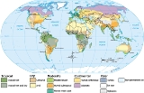
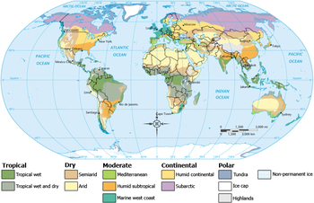
's climate varies widely, from arid
Arid
A region is said to be arid when it is characterized by a severe lack of available water, to the extent of hindering or even preventing the growth and development of plant and animal life...
in the west to humid
Humid subtropical climate
A humid subtropical climate is a climate zone characterized by hot, humid summers and mild to cool winters...
in the east. Due to its large size, Texas is home to several different climates. There are several distinct regions within the state which have varying climates: Northern Plains, Trans-Pecos
Trans-Pecos
The term Trans-Pecos, as originally defined in 1887 by the Texas geologist Robert T. Hill, refers to the portion of Texas that lies west of the Pecos River. The term is considered synonymous with "Far West Texas", a subdivision of West Texas...
Region, Texas Hill Country
Texas Hill Country
The Texas Hill Country is a vernacular term applied to a region of Central Texas featuring tall rugged hills consisting of thin layers of soil atop limestone or granite. It also includes the Llano Uplift and the second largest granite monadnock in the United States, Enchanted Rock, which is located...
, Piney Woods
Piney Woods
The Piney Woods is a temperate coniferous forest terrestrial ecoregion in the Southern United States covering of East Texas, southern Arkansas, western Louisiana, and southeastern Oklahoma. These coniferous forests are dominated by several species of pine as well as hardwoods including hickory and...
, and South Texas
South Texas
South Texas is a region of the U.S. state of Texas that lies roughly south of and including San Antonio. The southern and western boundary is the Rio Grande River, and to the east it is the Gulf of Mexico. The population of this region is about 3.7 million. The southern portion of this region is...
. Generally speaking, the eastern half of Texas is humid subtropical, while the western half is semi-arid (with some arid regions). While snowfall is more common across northern Texas than southern sections, large snowfall totals have occurred near and along the middle and upper Texas coasts.
Texas ranks first in tornado occurrence with an average of 139 per year. Tropical cyclone
Tropical cyclone
A tropical cyclone is a storm system characterized by a large low-pressure center and numerous thunderstorms that produce strong winds and heavy rain. Tropical cyclones strengthen when water evaporated from the ocean is released as the saturated air rises, resulting in condensation of water vapor...
s can impact the state from the Gulf of Mexico
Gulf of Mexico
The Gulf of Mexico is a partially landlocked ocean basin largely surrounded by the North American continent and the island of Cuba. It is bounded on the northeast, north and northwest by the Gulf Coast of the United States, on the southwest and south by Mexico, and on the southeast by Cuba. In...
, or from an overland trajectory originating in the eastern Pacific ocean
Pacific Ocean
The Pacific Ocean is the largest of the Earth's oceanic divisions. It extends from the Arctic in the north to the Southern Ocean in the south, bounded by Asia and Australia in the west, and the Americas in the east.At 165.2 million square kilometres in area, this largest division of the World...
. Those originating from the Gulf of Mexico are more likely to strike the upper Texas coast than elsewhere. Significant floods have occurred across the state throughout history, both from tropical cyclones and from stalled weather front
Weather front
A weather front is a boundary separating two masses of air of different densities, and is the principal cause of meteorological phenomena. In surface weather analyses, fronts are depicted using various colored lines and symbols, depending on the type of front...
s.
Northern Plains
| Monthly normal high and low temperatures (°F) for various Northern Plains cities | ||||||||||||
| City | Jan | Feb | Mar | Apr | May | Jun | Jul | Aug | Sep | Oct | Nov | Dec |
|---|---|---|---|---|---|---|---|---|---|---|---|---|
| Abilene | 55/32 | 61/37 | 69/44 | 77/52 | 85/61 | 91/69 | 95/72 | 94/71 | 87/64 | 78/54 | 65/42 | 57/34 |
| Amarillo | 49/23 | 54/27 | 62/34 | 71/42 | 79/52 | 87/61 | 91/65 | 89/64 | 82/56 | 72/45 | 58/32 | 50/24 |
| Lubbock | 52/24 | 58/29 | 66/36 | 75/45 | 83/56 | 90/64 | 92/68 | 90/66 | 83/58 | 74/47 | 62/35 | 53/26 |
| Midland | 60/29 | 66/34 | 74/41 | 82/48 | 89/58 | 94/65 | 96/68 | 94/67 | 88/61 | 80/51 | 68/39 | 61/31 |
| San Angelo | 58/29 | 63/34 | 71/42 | 79/50 | 86/59 | 91/66 | 95/70 | 94/68 | 88/63 | 79/51 | 67/39 | 59/31 |
| Wichita Falls | 52/29 | 58/34 | 67/41 | 76/49 | 84/59 | 92/68 | 97/72 | 96/71 | 88/64 | 77/52 | 64/40 | 54/31 |
| http://www.weatherbyday.com/texas/ | ||||||||||||
The Northern Plains' climate is semi-arid
Semi-arid
A semi-arid climate or steppe climate describes climatic regions that receive precipitation below potential evapotranspiration, but not extremely...
and is prone to drought, annually receiving between 16 and 32 inches (812.8 mm) of precipitation. During the summer, this area of state sees the most clear days. Winter nights commonly see temperatures fall below the freezing mark, or 32 °F (0 °C). The wettest months of the year are April and May. Tornadoes, caused by the convergence of westerly and southerly prevailing winds during the late spring
Spring (season)
Spring is one of the four temperate seasons, the transition period between winter and summer. Spring and "springtime" refer to the season, and broadly to ideas of rebirth, renewal and regrowth. The specific definition of the exact timing of "spring" varies according to local climate, cultures and...
, are common, making the region part of Tornado Alley
Tornado Alley
Tornado Alley is a colloquial and popular media term that most often refers to the area of the United States where tornadoes are most frequent. Although an official location is not defined, the area between the Rocky Mountains and Appalachian Mountains is usually associated with it.The areas...
. Poor land management, drought, and high wind speeds can cause large dust storms, minimized in modern times by improved land-management practices, but most troublesome in the 1930s during the Dust Bowl
Dust Bowl
The Dust Bowl, or the Dirty Thirties, was a period of severe dust storms causing major ecological and agricultural damage to American and Canadian prairie lands from 1930 to 1936...
period. The panhandle
Panhandle
A panhandle is an informal geographic term for an elongated arm-like protrusion of a geo-political entity, such as a subnational entity or a sovereign state.-Term:...
region, farthest from the Gulf of Mexico, experiences colder winters than the other regions of Texas.
Trans Pecos Region
| Monthly normal high and low temperatures (°F) for various Trans Pecos cities | ||||||||||||
| City | Jan | Feb | Mar | Apr | May | Jun | Jul | Aug | Sep | Oct | Nov | Dec |
|---|---|---|---|---|---|---|---|---|---|---|---|---|
| El Paso | 57/33 | 63/38 | 70/44 | 78/51 | 87/61 | 95/69 | 94/72 | 92/70 | 87/64 | 78/52 | 66/40 | 57/33 |
| http://www.weatherbyday.com/texas/ | ||||||||||||
The Trans-Pecos region, also known as Far West Texas and the Big Bend Country, is the farthest west region in geography, consisting of the Chihuahuan Desert and isolated mountain ranges. During fall, winter, and spring, it experiences the most clear days statewide. It is also the driest receiving an average annual rainfall of only 16 inches (406.4 mm) or less. The arid climate is the main reason for desertification
Desertification
Desertification is the degradation of land in drylands. Caused by a variety of factors, such as climate change and human activities, desertification is one of the most significant global environmental problems.-Definitions:...
of the land, but overgrazing is slowly widening the land area of that desert. In the mountain areas one can see coniferous forests in a wetter and more temperate environment. The wettest months in this region occur during the summer. Winds are strengthened as they are forced to push through canyons and valleys. In the flatter areas these winds are harvested into usable electricity.
Hill Country
| Monthly normal high and low temperatures (°F) for Hill Country cities | ||||||||||||
| City | Jan | Feb | Mar | Apr | May | Jun | Jul | Aug | Sep | Oct | Nov | Dec |
|---|---|---|---|---|---|---|---|---|---|---|---|---|
| Austin | 60/40 | 65/44 | 73/51 | 79/58 | 85/65 | 91/71 | 95/73 | 96/73 | 90/69 | 81/60 | 70/49 | 62/42 |
| San Antonio | 62/39 | 67/43 | 74/50 | 80/57 | 86/66 | 91/72 | 95/74 | 95/74 | 90/69 | 82/59 | 71/49 | 64/41 |
| Waco | 57/33 | 62/38 | 70/46 | 78/53 | 84/63 | 91/70 | 96/74 | 96/73 | 90/66 | 79/57 | 68/45 | 59/36 |
| http://www.weatherbyday.com/texas/ | ||||||||||||
The Texas Hill Country, or central Texas is shaped by its many rivers and hills. The climate is on the western edge of humid subtropical
Humid subtropical climate
A humid subtropical climate is a climate zone characterized by hot, humid summers and mild to cool winters...
, with cool winters and hot summers. The vegetation is both deciduous
Deciduous
Deciduous means "falling off at maturity" or "tending to fall off", and is typically used in reference to trees or shrubs that lose their leaves seasonally, and to the shedding of other plant structures such as petals after flowering or fruit when ripe...
in the river valleys, and coniferous where there is greater elevation. In a single year the region can receive up to 48 inches (1,219.2 mm) of rain, and flooding is common near rivers and in low lying areas. The wettest months of the year are April and May.
Piney Woods
| Monthly normal high and low temperatures (°F) for various Piney Woods locations | ||||||||||||
| City | Jan | Feb | Mar | Apr | May | Jun | Jul | Aug | Sep | Oct | Nov | Dec |
|---|---|---|---|---|---|---|---|---|---|---|---|---|
| Dallas | 55/36 | 61/41 | 69/49 | 77/56 | 84/65 | 92/73 | 96/77 | 96/76 | 89/69 | 79/58 | 66/47 | 57/39 |
| Fort Worth | 55/31 | 61/36 | 68/44 | 76/52 | 83/61 | 91/69 | 97/72 | 96/72 | 89/65 | 79/55 | 67/44 | 58/35 |
| Galveston | 62/50 | 64/52 | 70/58 | 75/65 | 81/72 | 87/78 | 89/80 | 89/79 | 87/76 | 80/68 | 71/59 | 64/52 |
| Houston | 63/45 | 67/48 | 74/55 | 79/61 | 86/68 | 91/74 | 94/75 | 93/75 | 89/72 | 82/62 | 73/53 | 65/47 |
| Port Arthur | 61/43 | 65/46 | 72/52 | 78/59 | 84/66 | 89/72 | 92/74 | 92/73 | 88/69 | 80/60 | 71/51 | 64/45 |
| http://www.weatherbyday.com/texas/ | ||||||||||||
The Piney Woods
Piney Woods
The Piney Woods is a temperate coniferous forest terrestrial ecoregion in the Southern United States covering of East Texas, southern Arkansas, western Louisiana, and southeastern Oklahoma. These coniferous forests are dominated by several species of pine as well as hardwoods including hickory and...
is the eastern region of Texas and is within the humid subtropical climate zone. It receives the most rainfall; more than 87 inches (2,209.8 mm) annually in the far east. This is due to the gulf currents that carry humid air to the region, where it condenses and precipitates out in the vicinity of sea breeze
Sea breeze
A sea-breeze is a wind from the sea that develops over land near coasts. It is formed by increasing temperature differences between the land and water; these create a pressure minimum over the land due to its relative warmth, and forces higher pressure, cooler air from the sea to move inland...
fronts as well as when extratropical cyclone
Extratropical cyclone
Extratropical cyclones, sometimes called mid-latitude cyclones or wave cyclones, are a group of cyclones defined as synoptic scale low pressure weather systems that occur in the middle latitudes of the Earth having neither tropical nor polar characteristics, and are connected with fronts and...
s move by. While coastal sections see the most cloudy days statewide and year-round, northern sections see the most clear days during the summer. The wettest months of the year are April and May. The area is prone to severe thunderstorms and tornadoes when the proper conditions exist, generally in the springtime. Hurricanes also strike the region, the most disastrous of which was the Galveston Hurricane of 1900
Galveston Hurricane of 1900
The Hurricane of 1900 made landfall on the city of Galveston in the U.S. state of Texas, on September 8, 1900.It had estimated winds of at landfall, making it a Category 4 storm on the Saffir-Simpson Hurricane Scale...
. More recently Hurricane Rita
Hurricane Rita
Hurricane Rita was the fourth-most intense Atlantic hurricane ever recorded and the most intense tropical cyclone ever observed in the Gulf of Mexico. Rita caused $11.3 billion in damage on the U.S. Gulf Coast in September 2005...
pummeled the Golden Triangle of southeast Texas. The higher humidity of the region amplifies the feeling of heat during the summer. During winter and spring along the immediate coast, temperatures are kept cool by relatively cool gulf waters. Dense advection fog can form when warm air moves over the cool shelf waters during February and March, stopping ship traffic for days.
South
| Monthly normal high and low temperatures (°F) for southern Texas cities | ||||||||||||
| City | Jan | Feb | Mar | Apr | May | Jun | Jul | Aug | Sep | Oct | Nov | Dec |
|---|---|---|---|---|---|---|---|---|---|---|---|---|
| Brownsville | 69/50 | 72/53 | 78/59 | 82/65 | 87/72 | 91/75 | 92/75 | 93/75 | 89/73 | 84/66 | 77/59 | 70/52 |
| Corpus Christi | 66/46 | 70/49 | 76/56 | 81/62 | 86/69 | 90/74 | 93/74 | 93/75 | 90/72 | 84/64 | 75/55 | 68/48 |
| Del Rio | 63/40 | 68/44 | 76/52 | 83/59 | 89/67 | 94/72 | 96/74 | 96/74 | 91/69 | 82/61 | 71/49 | 63/41 |
| Laredo | 68/44 | 73/48 | 82/56 | 89/63 | 95/70 | 100/74 | 102/75 | 99/75 | 93/71 | 86/63 | 76/53 | 68/45 |
| Victoria | 63/44 | 67/47 | 73/54 | 79/60 | 85/68 | 90/73 | 93/75 | 94/75 | 90/70 | 83/62 | 73/52 | 65/45 |
| http://www.weatherbyday.com/texas/ | ||||||||||||
The region of South Texas includes the semiarid ranch country and the wetter Rio Grande Valley
Rio Grande Valley
The Rio Grande Valley or the Lower Rio Grande Valley, informally called The Valley, is an area located in the southernmost tip of South Texas...
. Considered to be the southernmost tip of the American Great Plains
Great Plains
The Great Plains are a broad expanse of flat land, much of it covered in prairie, steppe and grassland, which lies west of the Mississippi River and east of the Rocky Mountains in the United States and Canada. This area covers parts of the U.S...
region, the inland region has rainfall that is similar to that of the Northern Plains. The coastal areas are nearly warm most of the year due to currents of the Gulf of Mexico, but can get cold in winter if a strong front comes in, and sometimes even causing snow at sea level. Summers are hot and humid. Rain in the coastal region is more abundant than in the inland region, and subtropical forests line the Rio Grande River. The wettest months of the year are April and May. Inland, where it is drier, ranches dominate the landscape, characterized by thick spiny brush and grasslands. The winters in the inland region are cold and dry as Arctic air makes it into the region, therefore making snow a rare occurrence due to the lack of humidity in winter, and the summers are for the most part hot and dry, but at times can be humid if winds come off the warmer Gulf of Mexico. Tornadoes can occur in this region, but less frequent than in other parts of the state.
Cold and snow
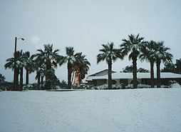
Vega, Texas
Vega is a city in Oldham County, Texas, United States. It is the county seat of Oldham County . The population was 936 at the 2000 census. A July 1, 2009, U.S. Census Bureau estimate placed the population at 896....
with Plainview, Texas
Plainview, Texas
Plainview is a city in and the county seat of Hale County, Texas, United States. The population was 22,336 at the 2000 census.-Geography:Plainview is located at ....
receiving 24 inches (61 cm) in one day. El Paso, in Far West Texas, received 22.4 in (57 cm) of snow during a 24-hour period 13-14 December 1987. For central and southern sections, snowfall is considerably more unusual, but not unprecedented. In February 1895, a large area of southeastern Texas received over 12 inches (30.5 cm) of snow, with peak amounts near 30 inches (76.2 cm) at Port Arthur, Texas
Port Arthur, Texas
-Demographics:As of the 2000 census, there were 57,755 people, 21,839 households, and 14,675 families residing in the city. The population density was 696.5 people per square mile . There were 24,713 housing units at an average density of 298.0 per square mile...
. More recently around Christmas
Christmas
Christmas or Christmas Day is an annual holiday generally celebrated on December 25 by billions of people around the world. It is a Christian feast that commemorates the birth of Jesus Christ, liturgically closing the Advent season and initiating the season of Christmastide, which lasts twelve days...
of 2004, up to 13 inches (33 cm) of snow fell along the middle coast, with the maximum occurring at Victoria, Texas
Victoria, Texas
Victoria is a city in and the seat of Victoria County, Texas, United States. The population was 60,603 at the 2000 census. The three counties of the Victoria Metropolitan Statistical Area had a population of 111,163 at the 2000 census,...
.
The worst cold snap to occur statewide occurred during the last half of December in 1983. Four stations recorded their longest continuous readings at or below 32 °F (0 °C) on record. At Austin, Texas
Austin, Texas
Austin is the capital city of the U.S. state of :Texas and the seat of Travis County. Located in Central Texas on the eastern edge of the American Southwest, it is the fourth-largest city in Texas and the 14th most populous city in the United States. It was the third-fastest-growing large city in...
, the temperature remained at or below freezing for 139 hours. At Abilene, Texas
Abilene, Texas
Abilene is a city in Taylor and Jones counties in west central Texas. The population was 117,063 at the 2010 census. It is the principal city of the Abilene Metropolitan Statistical Area, which had a 2006 estimated population of 158,063. It is the county seat of Taylor County...
, the period at or below freezing totaled 202 hours. Lubbock, Texas
Lubbock, Texas
Lubbock is a city in and the county seat of Lubbock County, Texas, United States. The city is located in the northwestern part of the state, a region known historically as the Llano Estacado, and the home of Texas Tech University and Lubbock Christian University...
saw temperatures at or below freezing for 207 hours. The Dallas-Fort Worth airport measured temperatures at or below freezing for a total of 296 consecutive hours. Snow which fell on December 14 and December 15 across northern Texas stayed on the ground until New Year's Day of 1984.
Severe weather
Thunderstorms are very common in Texas, especially the eastern and northern portion of the state. Texas is part of the Tornado AlleyTornado Alley
Tornado Alley is a colloquial and popular media term that most often refers to the area of the United States where tornadoes are most frequent. Although an official location is not defined, the area between the Rocky Mountains and Appalachian Mountains is usually associated with it.The areas...
section of the country. The state experiences the most tornado
Tornado
A tornado is a violent, dangerous, rotating column of air that is in contact with both the surface of the earth and a cumulonimbus cloud or, in rare cases, the base of a cumulus cloud. They are often referred to as a twister or a cyclone, although the word cyclone is used in meteorology in a wider...
es in the Union, an average of 139 a year. These strike most frequently in North Texas and the Panhandle. Tornadoes in Texas generally occur in the months of April, May, and June.
Hurricanes
Gulf of Mexico
The Gulf of Mexico is a partially landlocked ocean basin largely surrounded by the North American continent and the island of Cuba. It is bounded on the northeast, north and northwest by the Gulf Coast of the United States, on the southwest and south by Mexico, and on the southeast by Cuba. In...
makes it vulnerable to hurricanes. Some of the most destructive hurricanes in U.S. history have impacted Texas. A hurricane in 1875 killed approximately 400 people in Indianola
Indianola, Texas
Indianola is a ghost town located on Matagorda Bay in Calhoun County, Texas, United States. The community, once the county seat of Calhoun County, is a part of the Victoria, Texas, Metropolitan Statistical Area. In 1875, the city had a population of 5,000, but on September 15 of that year, a...
, followed by another hurricane
Indianola Hurricane of 1886
The Indianola Hurricane of 1886 destroyed the town of Indianola, Texas. It was one of the most intense hurricanes ever to hit the United States.-Meteorological history:...
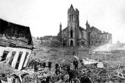
in 1886 that destroyed the town, which was at the time the most important port city in the state. This allowed Galveston
Galveston, Texas
Galveston is a coastal city located on Galveston Island in the U.S. state of Texas. , the city had a total population of 47,743 within an area of...
to take over as the chief port city, but it was subsequently devastated by a hurricane
Galveston Hurricane of 1900
The Hurricane of 1900 made landfall on the city of Galveston in the U.S. state of Texas, on September 8, 1900.It had estimated winds of at landfall, making it a Category 4 storm on the Saffir-Simpson Hurricane Scale...
in 1900 that killed approximately 8,000 people (possibly as many as 12,000), making it the deadliest natural disaster in U.S. history. Other devastating Texas hurricanes include the 1915 Galveston Hurricane
1915 Galveston Hurricane
The 1915 Galveston Hurricane was a deadly hurricane that struck Leeward Islands, Hispanola, Cuba and Texas, in mid August of the 1915 Atlantic hurricane season...
, Hurricane Carla
Hurricane Carla
Hurricane Carla was one of two Category 5 tropical cyclones during the 1961 Atlantic hurricane season. It struck the Texas coast as a Category 4 hurricane, becoming one of the most powerful storms to ever strike the United States. Hurricane Carla was the second most intense storm to ever...
in 1961, Hurricane Beulah
Hurricane Beulah
Hurricane Beulah was the second tropical storm, second hurricane, and only major hurricane during the 1967 Atlantic hurricane season. It tracked through the Caribbean, struck the Yucatán peninsula of Mexico as a major hurricane, and moved west-northwest into the Gulf of Mexico, briefly gaining...
in 1967, Hurricane Alicia
Hurricane Alicia
Hurricane Alicia was the costliest tropical cyclone in the Atlantic since Hurricane Agnes in 1972. Alicia was the third depression, the first tropical storm, and the only major hurricane of the 1983 Atlantic hurricane season...
in 1983, Hurricane Rita
Hurricane Rita
Hurricane Rita was the fourth-most intense Atlantic hurricane ever recorded and the most intense tropical cyclone ever observed in the Gulf of Mexico. Rita caused $11.3 billion in damage on the U.S. Gulf Coast in September 2005...
in 2005, and Hurricane Ike
Hurricane Ike
Hurricane Ike was the second-costliest hurricane ever to make landfall in the United States, the costliest hurricane ever to impact Cuba and the second most active hurricane to reach the Canadian mainland in the Great Lakes Region after Hurricane Hazel in 1954...
in 2008.
The climatology of where tropical cyclone strikes are most likely within the state appears to be changing. In the early 1980s, the most favored region for strikes during the previous century was the middle coast. However, that region of the coastline has been rarely impacted since the 1960s, and a recent study indicates that the most vulnerable location to a tropical cyclone strike since 1851 is the upper coast, which has received 56 percent of all tropical cyclone landfalls, of which 66 percent originate from the Gulf of Mexico. This is in contrast with Louisiana and the lower Texas coast, where only 39 percent of the landfalls are from tropical cyclones of Gulf of Mexico origin.
Flooding
The most serious threat from tropical cyclones in Texas residents is from flooding. The worst aspect about tropical cyclones is that the weaker they are, the more efficient they can be at producing heavy rains and catastrophic flooding. Systems with sprawling circulations, such as Hurricane BeulahHurricane Beulah
Hurricane Beulah was the second tropical storm, second hurricane, and only major hurricane during the 1967 Atlantic hurricane season. It tracked through the Caribbean, struck the Yucatán peninsula of Mexico as a major hurricane, and moved west-northwest into the Gulf of Mexico, briefly gaining...
, also tend to make good rainmakers. Slow moving systems, such as Tropical Storm Amelia (1978)
Tropical Storm Amelia (1978)
Tropical Storm Amelia was a weak, poorly-organized tropical storm that caused a severe flooding disaster in Texas during the 1978 Atlantic hurricane season. Amelia developed from a tropical wave on July 30 that entered an area of the Gulf of Mexico that was conductive for tropical cyclogenesis...
also can produce significant rainfall over the Lone Star State. Tropical cyclones from both the eastern Pacific and Atlantic Basins can impact the Lone Star State. In general, flooding across Texas is more common during the spring and early autumn months, and it can also be due to nearby stationary front
Stationary front
A stationary front is a boundary between two different air masses, neither of which is strong enough to replace the other. On a weather map, this is shown by an inter-playing series of blue spikes pointing one direction and red domes pointing the other. They tend to remain essentially in the same...
s interacting with strong upper level cyclone
Cyclone
In meteorology, a cyclone is an area of closed, circular fluid motion rotating in the same direction as the Earth. This is usually characterized by inward spiraling winds that rotate anticlockwise in the Northern Hemisphere and clockwise in the Southern Hemisphere of the Earth. Most large-scale...
s. The most likely location for floods statewide is the Balcones Escarpment, an area of steep elevation gradient in central Texas at the boundary between the Edwards Plateau
Edwards Plateau
The Edwards Plateau is a region of west-central Texas which is bounded by the Balcones Fault to the south and east, the Llano Uplift and the Llano Estacado to the north, and the Pecos River and Chihuahuan Desert to the west. San Angelo, Austin, San Antonio and Del Rio roughly outline the area...
and the coastal plain.
Climate change
Texas emits the most greenhouse gases in the US. The state's annual carbon dioxide emissions are nearly 1.5 trillion pounds (680 billion kg). Texas would be the world's seventh-largest producer of greenhouse gasGreenhouse gas
A greenhouse gas is a gas in an atmosphere that absorbs and emits radiation within the thermal infrared range. This process is the fundamental cause of the greenhouse effect. The primary greenhouse gases in the Earth's atmosphere are water vapor, carbon dioxide, methane, nitrous oxide, and ozone...
es if it were an independent nation. The primary factors in Texas' greenhouse gas emissions are the state's large number of coal power plants
Fossil fuel power plant
A fossil-fuel power station is a power station that burns fossil fuels such as coal, natural gas or petroleum to produce electricity. Central station fossil-fuel power plants are designed on a large scale for continuous operation...
and the state's refining and manufacturing industries which provides the bulk of the United States' petroleum products.