
1915 Galveston Hurricane
Encyclopedia
The 1915 Galveston Hurricane was a deadly hurricane that struck Leeward Islands
, Hispanola, Cuba
and Texas
, in mid August of the 1915 Atlantic hurricane season
. Striking Galveston, Texas
, 15 years after the 1900 Galveston Hurricane, its 21-ft (6.4-m) waves were slowed by the new Galveston Seawall
but changed the beach structure: on August 17, the entire 300-ft (91.5–m) beach was eroded to become an offshore sandbar, later returning partially, but never the same. The 1915 storm caused a great deal of destruction in its path, leaving 275-400 people dead and $50 million dollars (1915 USD
, $921 million 2005 USD
) in damage.
, the 1915 Hurricane was detected as a tropical storm moving westward on August 5. Then it was officially observed on August 10 as a Category 1
hurricane. By that time, the storm was centered north of Barbados
. On August 11, the eye of the hurricane passed south of the Virgin Islands
and Puerto Rico
. A weather station in San Juan
recorded a 29.60 inch (987 mbar) pressure reading and winds up to 60 mph (110 km/h). The hurricane continued to move westward between 18 and 20 mph (25–30 km/h) where it brushed Haiti
and made landfall in Jamaica
.
A barometric pressure reading of 29.68 inch (983 mbar) was reported in Jamaica
. The 1915 hurricane then turned slightly west-northwest, brushing Cuba
as it went along. Unfazed by the landfall on Jamaica
, the hurricane rapidly intensified and was located near Isle of Pines, Cuba
on August 14 with 145 mph (230 km/h) winds. On the 15th, the hurricane was in the central Gulf of Mexico
still moving in a northwesterly direction. On August 16, the center of the storm was approaching the east coast of Texas
, where the storm weakened slightly but was still a Category 4 storm.
On the 17th, the hurricane made landfall southwest of Galveston, Texas
. Atmospheric pressure at landfall was at 27.76 inches (940 mbar) and 135 mph (215 km/h) winds. After leaving Galveston, the weakening storm took a turn to the northeast and passed Houston as a Category 1
hurricane before dropping to tropical storm status later that day. On August 20, the dying storm passed over Missouri
and the Ohio Valley before finally becoming extratropical on August 23.
when the storm was detected on August 5. Forecasters then began to issue warnings to Haiti
and Cuba
on August 11. Evacuation reports in both Cuba and Haiti, however, are unavailable. After the storm hit Jamaica
, forecasters predicted the storm might hit southern and western Cuba. Between August 12 and 13, forecasters began to issue tropical storm warnings to the Florida Keys
and Miami, Florida
ahead of the storm due to shipping interests.
By August 13, the hurricane trekked westward as forecast. At 5 PM (EST), the tropical storm warnings were then changed to hurricane warnings which extended to the Florida Panhandle
. On the 14th, however, the hurricane did not recurve north and warnings for Miami and later the Florida Keys
were dropped, as the storm instead continued west-northwest. Because the 1915 hurricane was large (exact size unknown), forecasters began to issue tropical storm warnings from coastal Louisiana
to the Florida Panhandle. In addition, warnings were issued in Brownsville, Texas
. Since it was clear that the hurricane would make landfall in Texas
, the warnings were changed for the entire Texas coastline. After the hurricane made landfall, officials continued to issue warnings until the storm dissipated on August 23.
, Puerto Rico
, Hispaniola
and Cuba
. When the hurricane made landfall in Galveston, it brought heavy rains and strong winds, leaving $921 million (2005 USD
) in damage. However, unlike the 1900 Galveston Hurricane, only 11 people were killed in the Galveston town area, due to the Galveston Seawall
, built after the 1900 storm.
, the hurricane left moderate damage. In Martinique
, the hurricane flooded docks and wrecked small boats, but damage overall was minimal. Damage in the Leeward Islands
and Puerto Rico
was also limited to small boats and docks. No monetary value is available. In Jamaica
and Haiti
, there was serious crop damage but according to reports, there were no deaths.
In Cuba
, however, the damage was severe, as the hurricane devastated the town of Cape San Antonio
and destroyed a lighthouse and all of the weather equipment belonging the Weather Bureau
. Offshore, the hurricane damaged or sank two schooners, but there was no loss of life. Because of lack of advanced reporting, the death toll in Cuba is unknown.
, the Florida Keys
or Yucatán Peninsula
, the outer rainbands of the storm still produced tropical storm force winds and scattered downpours. In Key West
, gale-force winds were reported, but there were no reports of damage. Offshore, numerous ships and boats caught out in the hurricane limped home with moderate damage.
In the Yucatán Channel
, however, the hurricane sank a U.S. steamer Marowjine, bound from Belize
. Despite the fact that the ship was equipped with radios, the ship sank, drowning all 96 passengers and crew. In the northern Gulf of Mexico, a schooner sank several miles south of Mobile, Alabama
: there were three fatalities. Several miles east, off the coast of Pensacola, Florida
, there were two more fatalities when a fishing boat ran aground. In the central Gulf of Mexico
, another schooner was lost, but the crewmen survived.
In all, the hurricane left 101 people dead in the Gulf of Mexico
and Yucatán Channel
.
. The damage in Louisiana was <$1 million (1915 USD
), and it was limited to agriculture and marshes.
There were no reports of fatalities or injuries.
 The 1915 Hurricane made landfall on the Texas coast as a Category 4 hurricane with sustained winds of 135 mph (215 km/h). The areas in Texas
hardest hit were Galveston and Houston. In Galveston, the death toll was only eleven due to a recently built seawall. Elsewhere there were 111 fatalities (42 in Galveston Island
and 62 offshore), and 102 others were reported missing and assumed dead. Total damage was $56 million (1915 USD).
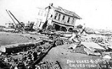
In Galveston, the hurricane brought 120 mph (200 km/h) winds and tides 9–14 feet above normal and a storm surge
of 16.2 feet (4.9 m).
The storm surge
of the hurricane partly damaged the seawall protecting Galveston, which resulted in severe flooding. At 39th street, the 4-masted schooner Crockett was picked up by the storm surge
, dragging 2 anchors to snag the seawall, and the schooner was broken into pieces atop the seawall. However the seawall held up, preventing a repeat of the 1900 Galveston Hurricane, but erosion behind damaged the pavement on top from 6th to 18th street. In addition, the hurricane completely washed out 300 ft (91.5 m) of beach up to the seawall, which became an offshore sandbar, but later returned partially, yet never the same.
Elsewhere in the city, many businesses were flooded with 5–6 feet of water. In Fort Crockett
, the hurricane destroyed or damaged many of the dune-protected forts and military equipment leaving $1 million (1915 USD
) in damage. In all, 250-300 homes outside the seawall were destroyed, and there were only a few deaths due to advanced warnings. In all, there was $6 million (1915 USD
) in damage and eleven deaths in the city of Galveston and 42 deaths elsewhere in Galveston Island
.
In Houston, the hurricane brought 80 mi/h winds and heavy rainfall that left $1 million (1915 USD
) in damage, but there were no reports of fatalities or deaths in the city. The storm significantly damaged much of the cotton, corn and rice harvests.
to New York
. Exact damage totals and reports of deaths or injuries are unknown.
). The damage to the bridge and a key water main caused a significant water shortage that lasted until August 16. The damage to post offices and radio stations disrupted mail service and communication.
Leeward Islands
The Leeward Islands are a group of islands in the West Indies. They are the northern islands of the Lesser Antilles chain. As a group they start east of Puerto Rico and reach southward to Dominica. They are situated where the northeastern Caribbean Sea meets the western Atlantic Ocean...
, Hispanola, Cuba
Cuba
The Republic of Cuba is an island nation in the Caribbean. The nation of Cuba consists of the main island of Cuba, the Isla de la Juventud, and several archipelagos. Havana is the largest city in Cuba and the country's capital. Santiago de Cuba is the second largest city...
and Texas
Texas
Texas is the second largest U.S. state by both area and population, and the largest state by area in the contiguous United States.The name, based on the Caddo word "Tejas" meaning "friends" or "allies", was applied by the Spanish to the Caddo themselves and to the region of their settlement in...
, in mid August of the 1915 Atlantic hurricane season
1915 Atlantic hurricane season
The 1915 Atlantic hurricane season ran through the summer and the first half of fall in 1915.-Storms:The 1915 season was not very active in terms of the number of storms but it was fairly eventful, with two powerful hurricanes hitting the Gulf Coast of the United States.-Hurricane One:The first...
. Striking Galveston, Texas
Galveston, Texas
Galveston is a coastal city located on Galveston Island in the U.S. state of Texas. , the city had a total population of 47,743 within an area of...
, 15 years after the 1900 Galveston Hurricane, its 21-ft (6.4-m) waves were slowed by the new Galveston Seawall
Galveston Seawall
The Galveston Seawall is a seawall in Galveston, Texas, USA that was built after the Galveston Hurricane of 1900 for protection from future hurricanes. Construction began in September, 1902, and the initial segment was completed on July 29, 1904. From 1904 to 1963, the seawall was extended from ...
but changed the beach structure: on August 17, the entire 300-ft (91.5–m) beach was eroded to become an offshore sandbar, later returning partially, but never the same. The 1915 storm caused a great deal of destruction in its path, leaving 275-400 people dead and $50 million dollars (1915 USD
United States dollar
The United States dollar , also referred to as the American dollar, is the official currency of the United States of America. It is divided into 100 smaller units called cents or pennies....
, $921 million 2005 USD
United States dollar
The United States dollar , also referred to as the American dollar, is the official currency of the United States of America. It is divided into 100 smaller units called cents or pennies....
) in damage.
Meteorological history
A Cape Verde type hurricaneCape Verde-type hurricane
A Cape Verde-type hurricane is an Atlantic hurricane that develops near the Cape Verde islands, off the west coast of Africa. The average hurricane season has about two Cape Verde-type hurricanes, which are usually the largest and most intense storms of the season because they often have plenty of...
, the 1915 Hurricane was detected as a tropical storm moving westward on August 5. Then it was officially observed on August 10 as a Category 1
Saffir-Simpson Hurricane Scale
The Saffir–Simpson Hurricane Scale , or the Saffir–Simpson Hurricane Wind Scale , classifies hurricanes — Western Hemisphere tropical cyclones that exceed the intensities of tropical depressions and tropical storms — into five categories distinguished by the intensities of their sustained winds...
hurricane. By that time, the storm was centered north of Barbados
Barbados
Barbados is an island country in the Lesser Antilles. It is in length and as much as in width, amounting to . It is situated in the western area of the North Atlantic and 100 kilometres east of the Windward Islands and the Caribbean Sea; therein, it is about east of the islands of Saint...
. On August 11, the eye of the hurricane passed south of the Virgin Islands
Virgin Islands
The Virgin Islands are the western island group of the Leeward Islands, which are the northern part of the Lesser Antilles, which form the border between the Caribbean Sea and the Atlantic Ocean...
and Puerto Rico
Puerto Rico
Puerto Rico , officially the Commonwealth of Puerto Rico , is an unincorporated territory of the United States, located in the northeastern Caribbean, east of the Dominican Republic and west of both the United States Virgin Islands and the British Virgin Islands.Puerto Rico comprises an...
. A weather station in San Juan
San Juan, Puerto Rico
San Juan , officially Municipio de la Ciudad Capital San Juan Bautista , is the capital and most populous municipality in Puerto Rico, an unincorporated territory of the United States. As of the 2010 census, it had a population of 395,326 making it the 46th-largest city under the jurisdiction of...
recorded a 29.60 inch (987 mbar) pressure reading and winds up to 60 mph (110 km/h). The hurricane continued to move westward between 18 and 20 mph (25–30 km/h) where it brushed Haiti
Haiti
Haiti , officially the Republic of Haiti , is a Caribbean country. It occupies the western, smaller portion of the island of Hispaniola, in the Greater Antillean archipelago, which it shares with the Dominican Republic. Ayiti was the indigenous Taíno or Amerindian name for the island...
and made landfall in Jamaica
Jamaica
Jamaica is an island nation of the Greater Antilles, in length, up to in width and 10,990 square kilometres in area. It is situated in the Caribbean Sea, about south of Cuba, and west of Hispaniola, the island harbouring the nation-states Haiti and the Dominican Republic...
.
A barometric pressure reading of 29.68 inch (983 mbar) was reported in Jamaica
Jamaica
Jamaica is an island nation of the Greater Antilles, in length, up to in width and 10,990 square kilometres in area. It is situated in the Caribbean Sea, about south of Cuba, and west of Hispaniola, the island harbouring the nation-states Haiti and the Dominican Republic...
. The 1915 hurricane then turned slightly west-northwest, brushing Cuba
Cuba
The Republic of Cuba is an island nation in the Caribbean. The nation of Cuba consists of the main island of Cuba, the Isla de la Juventud, and several archipelagos. Havana is the largest city in Cuba and the country's capital. Santiago de Cuba is the second largest city...
as it went along. Unfazed by the landfall on Jamaica
Jamaica
Jamaica is an island nation of the Greater Antilles, in length, up to in width and 10,990 square kilometres in area. It is situated in the Caribbean Sea, about south of Cuba, and west of Hispaniola, the island harbouring the nation-states Haiti and the Dominican Republic...
, the hurricane rapidly intensified and was located near Isle of Pines, Cuba
Cuba
The Republic of Cuba is an island nation in the Caribbean. The nation of Cuba consists of the main island of Cuba, the Isla de la Juventud, and several archipelagos. Havana is the largest city in Cuba and the country's capital. Santiago de Cuba is the second largest city...
on August 14 with 145 mph (230 km/h) winds. On the 15th, the hurricane was in the central Gulf of Mexico
Gulf of Mexico
The Gulf of Mexico is a partially landlocked ocean basin largely surrounded by the North American continent and the island of Cuba. It is bounded on the northeast, north and northwest by the Gulf Coast of the United States, on the southwest and south by Mexico, and on the southeast by Cuba. In...
still moving in a northwesterly direction. On August 16, the center of the storm was approaching the east coast of Texas
Texas
Texas is the second largest U.S. state by both area and population, and the largest state by area in the contiguous United States.The name, based on the Caddo word "Tejas" meaning "friends" or "allies", was applied by the Spanish to the Caddo themselves and to the region of their settlement in...
, where the storm weakened slightly but was still a Category 4 storm.
On the 17th, the hurricane made landfall southwest of Galveston, Texas
Galveston, Texas
Galveston is a coastal city located on Galveston Island in the U.S. state of Texas. , the city had a total population of 47,743 within an area of...
. Atmospheric pressure at landfall was at 27.76 inches (940 mbar) and 135 mph (215 km/h) winds. After leaving Galveston, the weakening storm took a turn to the northeast and passed Houston as a Category 1
Saffir-Simpson Hurricane Scale
The Saffir–Simpson Hurricane Scale , or the Saffir–Simpson Hurricane Wind Scale , classifies hurricanes — Western Hemisphere tropical cyclones that exceed the intensities of tropical depressions and tropical storms — into five categories distinguished by the intensities of their sustained winds...
hurricane before dropping to tropical storm status later that day. On August 20, the dying storm passed over Missouri
Missouri
Missouri is a US state located in the Midwestern United States, bordered by Iowa, Illinois, Kentucky, Tennessee, Arkansas, Oklahoma, Kansas and Nebraska. With a 2010 population of 5,988,927, Missouri is the 18th most populous state in the nation and the fifth most populous in the Midwest. It...
and the Ohio Valley before finally becoming extratropical on August 23.
Preparations
Forecasters began to issue advisories to weather stations in the United StatesUnited States
The United States of America is a federal constitutional republic comprising fifty states and a federal district...
when the storm was detected on August 5. Forecasters then began to issue warnings to Haiti
Haiti
Haiti , officially the Republic of Haiti , is a Caribbean country. It occupies the western, smaller portion of the island of Hispaniola, in the Greater Antillean archipelago, which it shares with the Dominican Republic. Ayiti was the indigenous Taíno or Amerindian name for the island...
and Cuba
Cuba
The Republic of Cuba is an island nation in the Caribbean. The nation of Cuba consists of the main island of Cuba, the Isla de la Juventud, and several archipelagos. Havana is the largest city in Cuba and the country's capital. Santiago de Cuba is the second largest city...
on August 11. Evacuation reports in both Cuba and Haiti, however, are unavailable. After the storm hit Jamaica
Jamaica
Jamaica is an island nation of the Greater Antilles, in length, up to in width and 10,990 square kilometres in area. It is situated in the Caribbean Sea, about south of Cuba, and west of Hispaniola, the island harbouring the nation-states Haiti and the Dominican Republic...
, forecasters predicted the storm might hit southern and western Cuba. Between August 12 and 13, forecasters began to issue tropical storm warnings to the Florida Keys
Florida Keys
The Florida Keys are a coral archipelago in southeast United States. They begin at the southeastern tip of the Florida peninsula, about south of Miami, and extend in a gentle arc south-southwest and then westward to Key West, the westernmost of the inhabited islands, and on to the uninhabited Dry...
and Miami, Florida
Florida
Florida is a state in the southeastern United States, located on the nation's Atlantic and Gulf coasts. It is bordered to the west by the Gulf of Mexico, to the north by Alabama and Georgia and to the east by the Atlantic Ocean. With a population of 18,801,310 as measured by the 2010 census, it...
ahead of the storm due to shipping interests.
By August 13, the hurricane trekked westward as forecast. At 5 PM (EST), the tropical storm warnings were then changed to hurricane warnings which extended to the Florida Panhandle
Florida Panhandle
The Florida Panhandle, an informal, unofficial term for the northwestern part of Florida, is a strip of land roughly 200 miles long and 50 to 100 miles wide , lying between Alabama on the north and the west, Georgia also on the north, and the Gulf of Mexico to the south. Its eastern boundary is...
. On the 14th, however, the hurricane did not recurve north and warnings for Miami and later the Florida Keys
Florida Keys
The Florida Keys are a coral archipelago in southeast United States. They begin at the southeastern tip of the Florida peninsula, about south of Miami, and extend in a gentle arc south-southwest and then westward to Key West, the westernmost of the inhabited islands, and on to the uninhabited Dry...
were dropped, as the storm instead continued west-northwest. Because the 1915 hurricane was large (exact size unknown), forecasters began to issue tropical storm warnings from coastal Louisiana
Louisiana
Louisiana is a state located in the southern region of the United States of America. Its capital is Baton Rouge and largest city is New Orleans. Louisiana is the only state in the U.S. with political subdivisions termed parishes, which are local governments equivalent to counties...
to the Florida Panhandle. In addition, warnings were issued in Brownsville, Texas
Brownsville, Texas
Brownsville is a city in the southernmost tip of the state of Texas, in the United States. It is located on the northern bank of the Rio Grande, directly north and across the border from Matamoros, Tamaulipas, Mexico. Brownsville is the 16th largest city in the state of Texas with a population of...
. Since it was clear that the hurricane would make landfall in Texas
Texas
Texas is the second largest U.S. state by both area and population, and the largest state by area in the contiguous United States.The name, based on the Caddo word "Tejas" meaning "friends" or "allies", was applied by the Spanish to the Caddo themselves and to the region of their settlement in...
, the warnings were changed for the entire Texas coastline. After the hurricane made landfall, officials continued to issue warnings until the storm dissipated on August 23.
Impact
The 1915 Hurricane took a path similar to the 1900 Galveston Hurricane, but it affected a large area as it brought strong winds and heavy rains to the Leeward IslandsLeeward Islands
The Leeward Islands are a group of islands in the West Indies. They are the northern islands of the Lesser Antilles chain. As a group they start east of Puerto Rico and reach southward to Dominica. They are situated where the northeastern Caribbean Sea meets the western Atlantic Ocean...
, Puerto Rico
Puerto Rico
Puerto Rico , officially the Commonwealth of Puerto Rico , is an unincorporated territory of the United States, located in the northeastern Caribbean, east of the Dominican Republic and west of both the United States Virgin Islands and the British Virgin Islands.Puerto Rico comprises an...
, Hispaniola
Hispaniola
Hispaniola is a major island in the Caribbean, containing the two sovereign states of the Dominican Republic and Haiti. The island is located between the islands of Cuba to the west and Puerto Rico to the east, within the hurricane belt...
and Cuba
Cuba
The Republic of Cuba is an island nation in the Caribbean. The nation of Cuba consists of the main island of Cuba, the Isla de la Juventud, and several archipelagos. Havana is the largest city in Cuba and the country's capital. Santiago de Cuba is the second largest city...
. When the hurricane made landfall in Galveston, it brought heavy rains and strong winds, leaving $921 million (2005 USD
United States dollar
The United States dollar , also referred to as the American dollar, is the official currency of the United States of America. It is divided into 100 smaller units called cents or pennies....
) in damage. However, unlike the 1900 Galveston Hurricane, only 11 people were killed in the Galveston town area, due to the Galveston Seawall
Galveston Seawall
The Galveston Seawall is a seawall in Galveston, Texas, USA that was built after the Galveston Hurricane of 1900 for protection from future hurricanes. Construction began in September, 1902, and the initial segment was completed on July 29, 1904. From 1904 to 1963, the seawall was extended from ...
, built after the 1900 storm.
Caribbean Sea
While crossing the Caribbean SeaCaribbean Sea
The Caribbean Sea is a sea of the Atlantic Ocean located in the tropics of the Western hemisphere. It is bounded by Mexico and Central America to the west and southwest, to the north by the Greater Antilles, and to the east by the Lesser Antilles....
, the hurricane left moderate damage. In Martinique
Martinique
Martinique is an island in the eastern Caribbean Sea, with a land area of . Like Guadeloupe, it is an overseas region of France, consisting of a single overseas department. To the northwest lies Dominica, to the south St Lucia, and to the southeast Barbados...
, the hurricane flooded docks and wrecked small boats, but damage overall was minimal. Damage in the Leeward Islands
Leeward Islands
The Leeward Islands are a group of islands in the West Indies. They are the northern islands of the Lesser Antilles chain. As a group they start east of Puerto Rico and reach southward to Dominica. They are situated where the northeastern Caribbean Sea meets the western Atlantic Ocean...
and Puerto Rico
Puerto Rico
Puerto Rico , officially the Commonwealth of Puerto Rico , is an unincorporated territory of the United States, located in the northeastern Caribbean, east of the Dominican Republic and west of both the United States Virgin Islands and the British Virgin Islands.Puerto Rico comprises an...
was also limited to small boats and docks. No monetary value is available. In Jamaica
Jamaica
Jamaica is an island nation of the Greater Antilles, in length, up to in width and 10,990 square kilometres in area. It is situated in the Caribbean Sea, about south of Cuba, and west of Hispaniola, the island harbouring the nation-states Haiti and the Dominican Republic...
and Haiti
Haiti
Haiti , officially the Republic of Haiti , is a Caribbean country. It occupies the western, smaller portion of the island of Hispaniola, in the Greater Antillean archipelago, which it shares with the Dominican Republic. Ayiti was the indigenous Taíno or Amerindian name for the island...
, there was serious crop damage but according to reports, there were no deaths.
In Cuba
Cuba
The Republic of Cuba is an island nation in the Caribbean. The nation of Cuba consists of the main island of Cuba, the Isla de la Juventud, and several archipelagos. Havana is the largest city in Cuba and the country's capital. Santiago de Cuba is the second largest city...
, however, the damage was severe, as the hurricane devastated the town of Cape San Antonio
Cape San Antonio, Cuba
Cape San Antonio, , is a cape which forms the western extremity of Cuba. It extends into the Yucatán Channel.-References:*Merriam-Webster's Geographical Dictionary, Third Edition. Springfield, Massachusetts: Merriam-Webster, Incorporated, 1997....
and destroyed a lighthouse and all of the weather equipment belonging the Weather Bureau
National Weather Service
The National Weather Service , once known as the Weather Bureau, is one of the six scientific agencies that make up the National Oceanic and Atmospheric Administration of the United States government...
. Offshore, the hurricane damaged or sank two schooners, but there was no loss of life. Because of lack of advanced reporting, the death toll in Cuba is unknown.
Yucatán Channel and Gulf of Mexico
Although the hurricane did not make landfall in western CubaCuba
The Republic of Cuba is an island nation in the Caribbean. The nation of Cuba consists of the main island of Cuba, the Isla de la Juventud, and several archipelagos. Havana is the largest city in Cuba and the country's capital. Santiago de Cuba is the second largest city...
, the Florida Keys
Florida Keys
The Florida Keys are a coral archipelago in southeast United States. They begin at the southeastern tip of the Florida peninsula, about south of Miami, and extend in a gentle arc south-southwest and then westward to Key West, the westernmost of the inhabited islands, and on to the uninhabited Dry...
or Yucatán Peninsula
Yucatán Peninsula
The Yucatán Peninsula, in southeastern Mexico, separates the Caribbean Sea from the Gulf of Mexico, with the northern coastline on the Yucatán Channel...
, the outer rainbands of the storm still produced tropical storm force winds and scattered downpours. In Key West
Key West
Key West is an island in the Straits of Florida on the North American continent at the southernmost tip of the Florida Keys. Key West is home to the southernmost point in the Continental United States; the island is about from Cuba....
, gale-force winds were reported, but there were no reports of damage. Offshore, numerous ships and boats caught out in the hurricane limped home with moderate damage.
In the Yucatán Channel
Yucatán Channel
The Yucatán Channel is a strait between Mexico and Cuba. It connects the Yucatán Basin of the Caribbean Sea with the Gulf of Mexico. The strait is across between Cape Catoche in Mexico and Cape San Antonio, Cuba and reaches a maximum depth of .-References:...
, however, the hurricane sank a U.S. steamer Marowjine, bound from Belize
Belize
Belize is a constitutional monarchy and the northernmost country in Central America. Belize has a diverse society, comprising many cultures and languages. Even though Kriol and Spanish are spoken among the population, Belize is the only country in Central America where English is the official...
. Despite the fact that the ship was equipped with radios, the ship sank, drowning all 96 passengers and crew. In the northern Gulf of Mexico, a schooner sank several miles south of Mobile, Alabama
Mobile, Alabama
Mobile is the third most populous city in the Southern US state of Alabama and is the county seat of Mobile County. It is located on the Mobile River and the central Gulf Coast of the United States. The population within the city limits was 195,111 during the 2010 census. It is the largest...
: there were three fatalities. Several miles east, off the coast of Pensacola, Florida
Pensacola, Florida
Pensacola is the westernmost city in the Florida Panhandle and the county seat of Escambia County, Florida, United States of America. As of the 2000 census, the city had a total population of 56,255 and as of 2009, the estimated population was 53,752...
, there were two more fatalities when a fishing boat ran aground. In the central Gulf of Mexico
Gulf of Mexico
The Gulf of Mexico is a partially landlocked ocean basin largely surrounded by the North American continent and the island of Cuba. It is bounded on the northeast, north and northwest by the Gulf Coast of the United States, on the southwest and south by Mexico, and on the southeast by Cuba. In...
, another schooner was lost, but the crewmen survived.
In all, the hurricane left 101 people dead in the Gulf of Mexico
Gulf of Mexico
The Gulf of Mexico is a partially landlocked ocean basin largely surrounded by the North American continent and the island of Cuba. It is bounded on the northeast, north and northwest by the Gulf Coast of the United States, on the southwest and south by Mexico, and on the southeast by Cuba. In...
and Yucatán Channel
Yucatán Channel
The Yucatán Channel is a strait between Mexico and Cuba. It connects the Yucatán Basin of the Caribbean Sea with the Gulf of Mexico. The strait is across between Cape Catoche in Mexico and Cape San Antonio, Cuba and reaches a maximum depth of .-References:...
.
Louisiana
The outerbands of the 1915 hurricane brought heavy rains and gale-force winds to LouisianaLouisiana
Louisiana is a state located in the southern region of the United States of America. Its capital is Baton Rouge and largest city is New Orleans. Louisiana is the only state in the U.S. with political subdivisions termed parishes, which are local governments equivalent to counties...
. The damage in Louisiana was <$1 million (1915 USD
United States dollar
The United States dollar , also referred to as the American dollar, is the official currency of the United States of America. It is divided into 100 smaller units called cents or pennies....
), and it was limited to agriculture and marshes.
There were no reports of fatalities or injuries.
Texas
Texas
Texas is the second largest U.S. state by both area and population, and the largest state by area in the contiguous United States.The name, based on the Caddo word "Tejas" meaning "friends" or "allies", was applied by the Spanish to the Caddo themselves and to the region of their settlement in...
hardest hit were Galveston and Houston. In Galveston, the death toll was only eleven due to a recently built seawall. Elsewhere there were 111 fatalities (42 in Galveston Island
Galveston Island
Galveston Island is a barrier island on the Texas Gulf coast in the United States, about 50 miles southeast of Houston. The entire island, with the exception of Jamaica Beach, is within the city limits of the City of Galveston....
and 62 offshore), and 102 others were reported missing and assumed dead. Total damage was $56 million (1915 USD).
In Galveston, the hurricane brought 120 mph (200 km/h) winds and tides 9–14 feet above normal and a storm surge
Storm surge
A storm surge is an offshore rise of water associated with a low pressure weather system, typically tropical cyclones and strong extratropical cyclones. Storm surges are caused primarily by high winds pushing on the ocean's surface. The wind causes the water to pile up higher than the ordinary sea...
of 16.2 feet (4.9 m).
The storm surge
Storm surge
A storm surge is an offshore rise of water associated with a low pressure weather system, typically tropical cyclones and strong extratropical cyclones. Storm surges are caused primarily by high winds pushing on the ocean's surface. The wind causes the water to pile up higher than the ordinary sea...
of the hurricane partly damaged the seawall protecting Galveston, which resulted in severe flooding. At 39th street, the 4-masted schooner Crockett was picked up by the storm surge
Storm surge
A storm surge is an offshore rise of water associated with a low pressure weather system, typically tropical cyclones and strong extratropical cyclones. Storm surges are caused primarily by high winds pushing on the ocean's surface. The wind causes the water to pile up higher than the ordinary sea...
, dragging 2 anchors to snag the seawall, and the schooner was broken into pieces atop the seawall. However the seawall held up, preventing a repeat of the 1900 Galveston Hurricane, but erosion behind damaged the pavement on top from 6th to 18th street. In addition, the hurricane completely washed out 300 ft (91.5 m) of beach up to the seawall, which became an offshore sandbar, but later returned partially, yet never the same.
Elsewhere in the city, many businesses were flooded with 5–6 feet of water. In Fort Crockett
Fort Crockett
Fort Crockett is a government reservation on Galveston Island overlookingthe Gulf of Mexico originally built as a defense installation to protect the city and harbor of Galveston and to secure the entrance to Galveston Bay,...
, the hurricane destroyed or damaged many of the dune-protected forts and military equipment leaving $1 million (1915 USD
United States dollar
The United States dollar , also referred to as the American dollar, is the official currency of the United States of America. It is divided into 100 smaller units called cents or pennies....
) in damage. In all, 250-300 homes outside the seawall were destroyed, and there were only a few deaths due to advanced warnings. In all, there was $6 million (1915 USD
United States dollar
The United States dollar , also referred to as the American dollar, is the official currency of the United States of America. It is divided into 100 smaller units called cents or pennies....
) in damage and eleven deaths in the city of Galveston and 42 deaths elsewhere in Galveston Island
Galveston Island
Galveston Island is a barrier island on the Texas Gulf coast in the United States, about 50 miles southeast of Houston. The entire island, with the exception of Jamaica Beach, is within the city limits of the City of Galveston....
.
In Houston, the hurricane brought 80 mi/h winds and heavy rainfall that left $1 million (1915 USD
United States dollar
The United States dollar , also referred to as the American dollar, is the official currency of the United States of America. It is divided into 100 smaller units called cents or pennies....
) in damage, but there were no reports of fatalities or deaths in the city. The storm significantly damaged much of the cotton, corn and rice harvests.
Rest of the United States
The dissipating remnants of the 1915 hurricane dumped heavy rains across the eastern Midwest and Ohio Valley states before fading out for good on August 23. The rains caused extensive flash flooding that left significant damage from MissouriMissouri
Missouri is a US state located in the Midwestern United States, bordered by Iowa, Illinois, Kentucky, Tennessee, Arkansas, Oklahoma, Kansas and Nebraska. With a 2010 population of 5,988,927, Missouri is the 18th most populous state in the nation and the fifth most populous in the Midwest. It...
to New York
New York
New York is a state in the Northeastern region of the United States. It is the nation's third most populous state. New York is bordered by New Jersey and Pennsylvania to the south, and by Connecticut, Massachusetts and Vermont to the east...
. Exact damage totals and reports of deaths or injuries are unknown.
Aftermath
In Galveston, a series of fires broke out after the storm's passage, and relief aid was slow because the causeway that connected Galveston to mainland Texas was badly damaged. The cost of repairing the bridge was $500,000 dollars (1915 USDUnited States dollar
The United States dollar , also referred to as the American dollar, is the official currency of the United States of America. It is divided into 100 smaller units called cents or pennies....
). The damage to the bridge and a key water main caused a significant water shortage that lasted until August 16. The damage to post offices and radio stations disrupted mail service and communication.
See also
- List of Atlantic hurricanes
- List of tropical cyclones
- Tropical cycloneTropical cycloneA tropical cyclone is a storm system characterized by a large low-pressure center and numerous thunderstorms that produce strong winds and heavy rain. Tropical cyclones strengthen when water evaporated from the ocean is released as the saturated air rises, resulting in condensation of water vapor...
External links
- View more pictures of the 1915 Galveston Hurricane at the University of Houston Digital Library